Potash in North Dakota - Department of Mineral Resources
Potash in North Dakota - Department of Mineral Resources
Potash in North Dakota - Department of Mineral Resources

You also want an ePaper? Increase the reach of your titles
YUMPU automatically turns print PDFs into web optimized ePapers that Google loves.
<strong>Potash</strong> <strong>in</strong> <strong>North</strong> <strong>Dakota</strong><br />
Introduction<br />
For the fi rst time <strong>in</strong> 34 years, the <strong>North</strong> <strong>Dakota</strong> Geological Survey<br />
has issued a subsurface m<strong>in</strong>eral permit for potash exploration.<br />
The permit was issued to <strong>Dakota</strong> Salts, LLC -- a wholly owned<br />
subsidiary <strong>of</strong> Sirius Exploration PLC. At least four earlier potash<br />
exploration wells have been drilled <strong>in</strong> northwestern <strong>North</strong> <strong>Dakota</strong>.<br />
In 1962, Texaco, Inc. drilled the TXL Storage no. 1 near the town<br />
<strong>of</strong> Lignite <strong>in</strong> Burke County. A cavern was created <strong>in</strong> the salt section<br />
<strong>of</strong> this well for propane storage. Three additional potash wells<br />
were drilled <strong>in</strong> 1976; two were drilled <strong>in</strong> Burke County and one <strong>in</strong><br />
Bott<strong>in</strong>eau County. Burl<strong>in</strong>gton <strong>North</strong>ern, Inc. drilled the Helm<strong>in</strong>g<br />
no. 4-11 <strong>in</strong> Bott<strong>in</strong>eau County. Chandler & Associates, Inc. drilled<br />
the Ew<strong>in</strong>g no. 3-3 and the Wilson no. 2-33 <strong>in</strong> Burke County, and<br />
farmed-out the potash section <strong>of</strong> these wells to Kalium Canada,<br />
Ltd.<br />
<strong>Potash</strong><br />
The term potash orig<strong>in</strong>ated <strong>in</strong> the early 16th century, referr<strong>in</strong>g to<br />
Ed Murphy<br />
the salt that rema<strong>in</strong>ed when a mixture <strong>of</strong> water and wood ashes were<br />
evaporated <strong>in</strong> an iron pot to form potassium carbonate (Wilton,<br />
2009). Today, potash is the common name typically applied<br />
to a variety <strong>of</strong> potassium salts (fi g. 1). In the Williston Bas<strong>in</strong>,<br />
potash primarily consists <strong>of</strong> potassium chloride (m<strong>in</strong>eral name<br />
sylvite) and hydrated potassium magnesium chloride (m<strong>in</strong>eral<br />
name carnallite). <strong>Potash</strong> spot market prices or m<strong>in</strong><strong>in</strong>g statistics<br />
are typically reported as either KCl (potassium chloride) or K 2 O<br />
(potassium oxide) equivalent.<br />
The Prairie Formation<br />
<strong>North</strong> <strong>Dakota</strong> was covered, or partially covered, by seas throughout<br />
most <strong>of</strong> Paleozoic, Mesozoic, and early Cenozoic time (60 to 500<br />
million years ago). The Williston Bas<strong>in</strong> orig<strong>in</strong>ated about 500<br />
million years ago (Late Cambrian to Early Ordovician) becom<strong>in</strong>g<br />
the primary receptacle for sediment deposition <strong>in</strong> an area that<br />
<strong>in</strong>cludes western <strong>North</strong> <strong>Dakota</strong>, northwestern South <strong>Dakota</strong>, eastern<br />
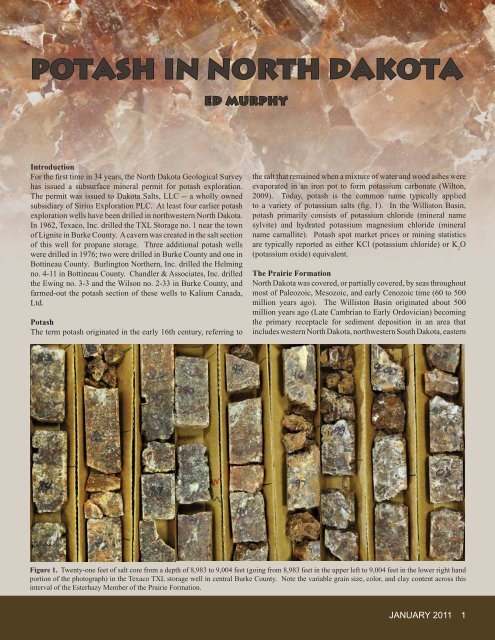
Figure 1. Twenty-one feet <strong>of</strong> salt core from a depth <strong>of</strong> 8,983 to 9,004 feet (go<strong>in</strong>g from 8,983 feet <strong>in</strong> the upper left to 9,004 feet <strong>in</strong> the lower right hand<br />
portion <strong>of</strong> the photograph) <strong>in</strong> the Texaco TXL storage well <strong>in</strong> central Burke County. Note the variable gra<strong>in</strong> size, color, and clay content across this<br />
<strong>in</strong>terval <strong>of</strong> the Esterhazy Member <strong>of</strong> the Prairie Formation.<br />
JANUARY 2011 1
Figure 2a. An isopach map (thickness) <strong>of</strong> the Prairie Formation and the extent <strong>of</strong> potash zones with<strong>in</strong> that formation. 2b. Depth to the Prairie<br />
Formation and locations <strong>of</strong> operat<strong>in</strong>g potash m<strong>in</strong>es. M<strong>in</strong>e locations taken from the Saskatchewan M<strong>in</strong>istry <strong>of</strong> Energy and <strong>Resources</strong> Operat<strong>in</strong>g M<strong>in</strong>es<br />
List published <strong>in</strong> March 2010.<br />
Montana, southern Saskatchewan, and southwestern Manitoba.<br />
Periodically, these seas deposited evaporite m<strong>in</strong>erals when they<br />
became isolated from the open oceans. Evaporites are deposited <strong>in</strong><br />
waters confi ned with<strong>in</strong> closed bas<strong>in</strong>s where circulation is impeded<br />
and the rate <strong>of</strong> evaporation exceeds the rate <strong>of</strong> recharge. As the<br />
volume <strong>of</strong> water is reduced the concentration <strong>of</strong> dissolved salts<br />
<strong>in</strong>creases until eventually they beg<strong>in</strong> to precipitate out <strong>of</strong> solution<br />
and are deposited on the bas<strong>in</strong> fl oor. This scenario <strong>of</strong> evaporite<br />
deposition repeated itself at least two dozen times with<strong>in</strong> the<br />
<strong>North</strong> <strong>Dakota</strong> portion <strong>of</strong> the Williston Bas<strong>in</strong>. As a result, there<br />
are about 24 salt layers <strong>in</strong> the bas<strong>in</strong> rang<strong>in</strong>g <strong>in</strong> thickness from a<br />
few feet up to hundreds <strong>of</strong> feet (LeFever and LeFever, 2005). The<br />
thickest accumulation <strong>of</strong> salt <strong>in</strong> the bas<strong>in</strong> occurs with<strong>in</strong> the Prairie<br />
Formation (Devonian).<br />
Dur<strong>in</strong>g the Middle Devonian, roughly 400 million years ago,<br />
the Williston Bas<strong>in</strong> was some distance from the open ocean, but<br />
connected to it through an elongated northwest-southeast trend<strong>in</strong>g<br />
trough called the Elk Po<strong>in</strong>t Bas<strong>in</strong>. The Elk Po<strong>in</strong>t Bas<strong>in</strong> extended<br />
from northwestern <strong>North</strong> <strong>Dakota</strong> to northern Alberta (fi g. 2a).<br />
Early <strong>in</strong> the Middle Devonian, two structural divides created<br />
three sub-bas<strong>in</strong>s with<strong>in</strong> the Elk Po<strong>in</strong>t Bas<strong>in</strong>, the southernmost<br />
sub-bas<strong>in</strong> covered Saskatchewan, Manitoba, <strong>North</strong> <strong>Dakota</strong>, and<br />
Montana. The poorly circulat<strong>in</strong>g water with<strong>in</strong> these sub-bas<strong>in</strong>s<br />
began to precipitate salt, creat<strong>in</strong>g the Prairie Formation, or the<br />
Prairie Evaporite as it is known <strong>in</strong> Canada. The Prairie Formation<br />
extends from northwestern <strong>North</strong> <strong>Dakota</strong> <strong>in</strong>to northern Alberta.<br />
Throughout much <strong>of</strong> Saskatchewan and northwestern <strong>North</strong><br />
<strong>Dakota</strong> the Prairie Formation is 300 to 500 feet thick (fi g. 2a).<br />
While halite (sodium chloride, NaCl, typically known as table<br />
salt) and anhydrite (calcium sulfate, CaSO 4 ) are the dom<strong>in</strong>ant<br />
evaporites with<strong>in</strong> the Elk Po<strong>in</strong>t Bas<strong>in</strong>, potash was also deposited<br />
<strong>in</strong> the sub-bas<strong>in</strong> that covered parts <strong>of</strong> Saskatchewan, Manitoba,<br />
2 GEO NEWS<br />
<strong>North</strong> <strong>Dakota</strong>, and Montana creat<strong>in</strong>g the largest potash deposit <strong>in</strong><br />
the world. This deposit extends over an area <strong>of</strong> 76,000 square<br />
miles, more than the total land area <strong>of</strong> <strong>North</strong> <strong>Dakota</strong> (71,000<br />
square miles). Roughly 12,000 square miles <strong>of</strong> this potash deposit<br />
is situated <strong>in</strong> northwestern <strong>North</strong> <strong>Dakota</strong>.<br />
<strong>Potash</strong> is concentrated <strong>in</strong>to three zones with<strong>in</strong> the Prairie<br />
Formation because m<strong>in</strong>erals have different solubilities. M<strong>in</strong>erals<br />
typically precipitate from seawater <strong>in</strong> the follow<strong>in</strong>g order: calcite<br />
and dolomite, gypsum and anhydrite, halite, sylvite and carnallite,<br />
etc. By the time the potassium salts began to precipitate <strong>in</strong> the Elk<br />
Po<strong>in</strong>t Bas<strong>in</strong>, much <strong>of</strong> the seawater had evaporated. The presence<br />
<strong>of</strong> halite both above and between the potash zones <strong>in</strong>dicates that<br />
water levels periodically rose <strong>in</strong> the bas<strong>in</strong>s and the evaporative<br />
cycle began all over aga<strong>in</strong>.<br />
Complicat<strong>in</strong>g the stratigraphy <strong>of</strong> the Prairie Formation is the<br />
dissolution <strong>of</strong> some <strong>of</strong> the salt over time. This dissolution is<br />
especially evident along the edges <strong>of</strong> the deposit. Salt collapse<br />
with<strong>in</strong> the Prairie Formation has affected overly<strong>in</strong>g rocks and <strong>in</strong><br />
some cases has been credited with creat<strong>in</strong>g traps or <strong>in</strong>duc<strong>in</strong>g faults<br />
and fractures <strong>in</strong>to the overly<strong>in</strong>g formations that are associated with<br />
oil production (LeFever and LeFever, 2005).<br />
Most <strong>of</strong> the salt with<strong>in</strong> the Prairie Formation, whether <strong>in</strong> Canada or<br />
<strong>in</strong> the United States, is halite. <strong>Potash</strong> makes up only about 10% <strong>of</strong><br />
the formation by volume and is concentrated <strong>in</strong> three zones. The<br />
uppermost potash zone is discont<strong>in</strong>uous across the <strong>in</strong>ternational<br />
border and is called the Mountrail Member <strong>in</strong> <strong>North</strong> <strong>Dakota</strong> and the<br />
Patience Lake Member <strong>in</strong> Saskatchewan. The other two members,<br />
the Belle Pla<strong>in</strong>e and Esterhazy, are remarkably cont<strong>in</strong>uous and can<br />
be correlated from Saskatchewan <strong>in</strong>to Manitoba, Montana, and<br />
<strong>North</strong> <strong>Dakota</strong> (Anderson and Sw<strong>in</strong>ehart, 1979) (fi g. 3).
Figure 3. An east-west cross section (correlat<strong>in</strong>g to red l<strong>in</strong>e on <strong>in</strong>set map) to the base <strong>of</strong> Devonian rocks <strong>in</strong> northwestern <strong>North</strong> <strong>Dakota</strong>. The lower<br />
expanded cross section <strong>of</strong> the Prairie Formation demonstrates its variable thickness as well as the lenticular nature <strong>of</strong> the potash beds (dark green)<br />
with<strong>in</strong> the Belle Pla<strong>in</strong>e and Esterhazy Members. Most <strong>of</strong> the salt <strong>in</strong> the lime green and light green portion <strong>of</strong> the lower diagram is halite.<br />
History <strong>of</strong> <strong>Potash</strong> M<strong>in</strong><strong>in</strong>g <strong>in</strong> the Prairie Formation<br />
<strong>Potash</strong> m<strong>in</strong><strong>in</strong>g began <strong>in</strong> Saskatchewan <strong>in</strong> 1959 and by 1971 the<br />
n<strong>in</strong>e potash m<strong>in</strong>es currently operat<strong>in</strong>g were all <strong>in</strong> production. Of<br />
these m<strong>in</strong>es; seven are underground work<strong>in</strong>gs, one is a fl ooded<br />
underground m<strong>in</strong>e now operated as a solution m<strong>in</strong>e (Patience<br />
Lake), and another is a solution m<strong>in</strong>e (Belle Pla<strong>in</strong>e). It has been<br />
estimated that Saskatchewan conta<strong>in</strong>s 63.5 billion metric tons<br />
<strong>of</strong> recoverable potash reserves (reported as K 2 O). This amount<br />
<strong>in</strong>cludes 4.5 billion metric tons <strong>of</strong> potash that could be m<strong>in</strong>ed by<br />
conventional underground methods and 59 billion metric tons by<br />
solution m<strong>in</strong><strong>in</strong>g techniques (modifi ed from Holter, 1969). The cut<br />
<strong>of</strong>f between conventional underground m<strong>in</strong><strong>in</strong>g and solution m<strong>in</strong><strong>in</strong>g<br />
has been placed at about 3,600 feet, beyond which conventional<br />
underground salt m<strong>in</strong><strong>in</strong>g is not considered safe (Halabura and<br />
Hardy, 2007) (fi g. 2b).<br />
Production and Uses <strong>of</strong> <strong>Potash</strong><br />
Canada is the lead<strong>in</strong>g producer <strong>of</strong> potash <strong>in</strong> the world. In 2008,<br />
Canada produced 10.5 million metric tons <strong>of</strong> potash (K 2 O<br />
equivalent), account<strong>in</strong>g for approximately one third <strong>of</strong> the world’s<br />
production <strong>of</strong> 35 million metric tons (fi g. 4). Russia, Belarus,<br />
Germany, Ch<strong>in</strong>a, Israel, Jordan, and the United States are, <strong>in</strong> that<br />
order, the other lead<strong>in</strong>g potash producers (Jas<strong>in</strong>ski, 2010a). Almost<br />
half (45%) <strong>of</strong> the potash m<strong>in</strong>ed <strong>in</strong> the prov<strong>in</strong>ce <strong>of</strong> Saskatchewan<br />
is consumed <strong>in</strong> the U.S. In contrast, only about fi ve percent <strong>of</strong><br />
Saskatchewan’s potash is consumed with<strong>in</strong> Canada. The rema<strong>in</strong><strong>in</strong>g<br />
50% or so <strong>of</strong> Saskatchewan’s potash production goes to the Pacifi c<br />
Rim (Ch<strong>in</strong>a, Japan, Malaysia, Korea, and Indonesia) and Lat<strong>in</strong><br />
American countries (F<strong>in</strong>k and Berenyi, 2010).<br />
In 2008, the United States m<strong>in</strong>ed about 1.1 million metric tons<br />
<strong>of</strong> potash (K 2 O equivalent). In the meantime, the United States<br />
imported 5.7 million metric tons, 87% <strong>of</strong> these imports com<strong>in</strong>g<br />
from Canada. Most <strong>of</strong> the potash produced with<strong>in</strong> the U.S. <strong>in</strong> recent<br />
years has come from southeastern New Mexico, but there has also<br />
been domestic potash production <strong>in</strong> Michigan and Utah (Jas<strong>in</strong>ski,<br />
2010a). The potash deposits <strong>in</strong> northwestern <strong>North</strong> <strong>Dakota</strong> and<br />
northeastern Montana are recognized as the largest deposits <strong>in</strong><br />
the United States. While Anderson and Sw<strong>in</strong>ehart (1979) placed<br />
the resource at 60 billion tons (50 billion <strong>in</strong> <strong>North</strong> <strong>Dakota</strong> and 10<br />
billion tons <strong>in</strong> Montana) the U.S. Geological Survey estimates the<br />
total U.S. potash resource at roughly 7 billion metric tons, with<br />
the majority <strong>of</strong> that occur<strong>in</strong>g <strong>in</strong> northwestern <strong>North</strong> <strong>Dakota</strong> and<br />
northeastern Montana (Jas<strong>in</strong>ski, 2010a).<br />
JANUARY 2011 3
Worldwide, 93% <strong>of</strong> the potash m<strong>in</strong>ed is used as agricultural<br />
fertilizer (Jas<strong>in</strong>ski, 2010b). Typically, the nitrogen,<br />
phosphorus, and potassium contents <strong>of</strong> fertilizer are<br />
labeled, <strong>in</strong> that order, on the fertilizer bag. In other words,<br />
a fertilizer bag labeled 22-2-14 conta<strong>in</strong>s 14% potassium by<br />
weight. <strong>Potash</strong> is used <strong>in</strong> a variety <strong>of</strong> other applications<br />
<strong>in</strong>clud<strong>in</strong>g alum<strong>in</strong>um recycl<strong>in</strong>g, metal electroplat<strong>in</strong>g, oil<br />
and gas drill<strong>in</strong>g, mud, snow and ice melt<strong>in</strong>g, steel heattreat<strong>in</strong>g,<br />
and water s<strong>of</strong>ten<strong>in</strong>g (Jas<strong>in</strong>ski, 2010b).<br />
Price and Outlook <strong>of</strong> <strong>Potash</strong><br />
Throughout the 1980s and 1990s the spot price for potash<br />
was less than $200 per metric ton <strong>of</strong> KCl. As was the<br />
case with many m<strong>in</strong>eral commodities, potash prices began<br />
<strong>in</strong>creas<strong>in</strong>g <strong>in</strong> the mid 2000s sett<strong>in</strong>g a record price <strong>in</strong><br />
2008 (fi g. 5). A potash price projection <strong>in</strong> the mid 2000s<br />
predicted that the KCl spot price would beg<strong>in</strong> dramatically<br />
<strong>in</strong>creas<strong>in</strong>g <strong>in</strong> 2007, peak at $1,375 <strong>in</strong> 2011, and would stay<br />
above $1,000 per metric ton through the year 2020. Much<br />
<strong>of</strong> this speculation was driven by projected <strong>in</strong>creases <strong>in</strong><br />
potash consumption with<strong>in</strong> Ch<strong>in</strong>a and India.<br />
The worldwide economic downturn has driven prices far<br />
below the record high, but they are still more than twice<br />
the average price <strong>of</strong> ten years ago (fi g. 5).<br />
In 2009, worldwide production <strong>of</strong> potash dropped 29%<br />
References<br />
Anderson, S.B., and Sw<strong>in</strong>ehart, R.P., 1979, <strong>Potash</strong> salts <strong>in</strong> the Williston<br />
Bas<strong>in</strong>, U.S.A.: Economic Geology, v. 74, no. 2, p. 358-376.<br />
F<strong>in</strong>k, R., and Berenyi, J., 2010, <strong>Potash</strong> fact sheet: Saskatchewan Energy<br />
and <strong>Resources</strong>, Saskatchewan M<strong>in</strong>erals, 2 p.<br />
Halabura, S.P. and Hardy, M.P., 2007, An overview <strong>of</strong> the geology<br />
<strong>of</strong> solution m<strong>in</strong><strong>in</strong>g <strong>of</strong> potash <strong>in</strong> Saskatcehwan: Solution M<strong>in</strong><strong>in</strong>g<br />
Research Institute Technical Meet<strong>in</strong>g, Halifax, Nova Scotia, Canada,<br />
Oct. 27, 18 p.<br />
Holter, M.E., 1969, The Middle Devonian Prairie Evaporite <strong>of</strong><br />
Saskatchewan: Saskatchewan Dept <strong>of</strong> M<strong>in</strong>eral <strong>Resources</strong>, Industrial<br />
M<strong>in</strong>erals Division Rept. no. 123, 101 p.<br />
Jas<strong>in</strong>ski, S.M., 2010a, <strong>Potash</strong> m<strong>in</strong>eral commodity surveys 2010: United<br />
States Geological Survey, p. 122-123.<br />
4 GEO NEWS<br />
Figure 4. World, Canadian, and U.S.<br />
production <strong>of</strong> potash from 1990 through<br />
2009. Source: U.S. Bureau <strong>of</strong> M<strong>in</strong>es and<br />
U.S. Geological Survey M<strong>in</strong>eral Commodity<br />
Surveys.<br />
Figure 5. <strong>Potash</strong> spot market prices from 1980 thru 2010 and projected prices<br />
from 2005-2020. The projected prices were estimated <strong>in</strong> the mid 2000s and did not<br />
foresee the worldwide economic downturn that began <strong>in</strong> 2008. Source: Fertecon.<br />
(down from 35 to 25 million metric tons <strong>of</strong> K 2 O) as a result <strong>of</strong> the decrease<br />
<strong>in</strong> potash demand stemm<strong>in</strong>g from the economic downturn. Canadian<br />
potash production dropped 38%, go<strong>in</strong>g from 10.5 million metric tons <strong>in</strong><br />
2008 to 6.5 million <strong>in</strong> 2009. U.S. production decreased 24% to 840,000<br />
metric tons <strong>in</strong> 2009 (fi g. 4). <strong>Potash</strong> production has been recover<strong>in</strong>g <strong>in</strong> 2010<br />
to near pre-2009 levels. Go<strong>in</strong>g forward, as the world economy recovers,<br />
some <strong>in</strong> the <strong>in</strong>dustry are predict<strong>in</strong>g potash will cont<strong>in</strong>ue to <strong>in</strong>crease at the<br />
past decade’s rate <strong>of</strong> about 2.5% per year (Stone, 2009).<br />
Jas<strong>in</strong>ski, S.M., 2010b, <strong>Potash</strong> (advanced release) <strong>in</strong> 2008 M<strong>in</strong>erals<br />
yearbook: United States Geological Survey, p. 58.1-58.9.<br />
LeFever, J.A., and LeFever, R.D., 2005, Salts <strong>in</strong> the Williston Bas<strong>in</strong>, <strong>North</strong><br />
<strong>Dakota</strong>: <strong>North</strong> <strong>Dakota</strong> Geological Survey Report <strong>of</strong> Investigation no.<br />
103, 41 p.<br />
Stone, K., 2009, <strong>Potash</strong> outlook: Natural <strong>Resources</strong> Canada, TFI fertilizer<br />
outlook and technology conference, Tampa, Florida, October 29.<br />
TGI Williston Bas<strong>in</strong> Work<strong>in</strong>g Group 2008: Devonian Prairie Evaporite:<br />
isopach; Manitoba Science, Technology, Energy and M<strong>in</strong>es,<br />
Manitoba Geological Survey, Stratigraphic Map SM2008-DPE-I,<br />
scale 1:1,000,000, www.WillistonTGI.com.<br />
Wilton, D., 2009, Potassium/potash, Wordorig<strong>in</strong>s.org, Sept. 3,<br />
www.wordorig<strong>in</strong>s.org/<strong>in</strong>dex.php/site/comments/potassium_potash/