

The Planning System and Flood Risk Management - Offaly County ...
The Planning System and Flood Risk Management - Offaly County ...
The Planning System and Flood Risk Management - Offaly County ...

You also want an ePaper? Increase the reach of your titles
YUMPU automatically turns print PDFs into web optimized ePapers that Google loves.
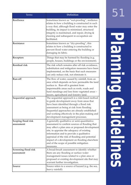
TermsDefinition51ResilienceResistanceReceptorsResidual riskRun-offSequential approachScoping flood riskassessmentScreening flood riskassessmentSourceSometimes known as “wet-proofing”, resiliencerelates to how a building is constructed in sucha way that, although flood water may enter thebuilding, its impact is minimised, structuralintegrity is maintained, <strong>and</strong> repair, drying &cleaning <strong>and</strong> subsequent re-occupation arefacilitated.Sometimes known as “dry-proofing”, thisrelates to how a building is constructed toprevent flood water entering the building ordamaging its fabric.Things that may be harmed by flooding (e.g.people, houses, buildings or the environment).<strong>The</strong> risk which remains after all risk avoidance,substitution <strong>and</strong> mitigation measures have beenimplemented, on the basis that such measurescan only reduce risk, not eliminate it.<strong>The</strong> flow of water, caused by rainfall, from anarea which depends on how permeable the l<strong>and</strong>surface is. Run-off is greatest fromimpermeable areas such as roofs, roads <strong>and</strong>hard st<strong>and</strong>ings <strong>and</strong> less from vegetated areas –moors, agricultural <strong>and</strong> forestry l<strong>and</strong>.<strong>The</strong> sequential approach is a risk-based methodto guide development away from areas thathave been identified through a flood riskassessment as being at risk from flooding.Sequential approaches are already established<strong>and</strong> working effectively in the plan-making <strong>and</strong>development management processes.A generally qualitative or semi-quantitativeassessment to confirm sources of flooding thatmay affect a plan area or proposed developmentsite, to appraise the adequacy of existinginformation <strong>and</strong> to provide a qualitativeappraisal of the risk of flooding <strong>and</strong> potentialimpact of a development on flooding elsewhere<strong>and</strong> of the scope of possible mitigationmeasures.A broad-brush assessment to identify whetherthere are any flooding or surface watermanagement issues related to a plan area orproposed or existing development site that maywarrant further investigation.Source refers to a source of hazard (e.g. the sea,heavy rainfall).<strong>Planning</strong> Guidelines


