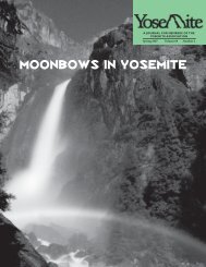
Pathways: A Story of Trails and Men (1968), by John W ... - Yosemite
Pathways: A Story of Trails and Men (1968), by John W ... - Yosemite
Pathways: A Story of Trails and Men (1968), by John W ... - Yosemite
- No tags were found...

You also want an ePaper? Increase the reach of your titles
YUMPU automatically turns print PDFs into web optimized ePapers that Google loves.
Inspiration Point. From here a quick descent to the floor <strong>of</strong> the Valley near the base <strong>of</strong> Bridalveil Falls was made. This route is essentiallythe same as the present combination <strong>of</strong> the Alder Creek-Pohono <strong>Trails</strong>.“Undoubtedly, the presence <strong>of</strong> the meadows along this route with their abundant stock-feed was the compelling motive for locating thetrail in this manner. The old Indian trail which followed a lower elevation through the timber did not <strong>of</strong>fer this advantage. Several yearslater two sheep camps, known as Westfall’s <strong>and</strong> Ostr<strong>and</strong>er’s, were set up in the vicinity <strong>of</strong> these meadows, <strong>and</strong> the crude shelters whichwere available served occasionally as a hospice for those who desired a respite from the long ride.“In 1857, Galen Clark, who was to become a prominent figure in <strong>Yosemite</strong> history, established himself at the meadow where the trailcrossed the South Fork, where Wawona is now located. Here he provided overnight accommodations to the many travelers on theirway to <strong>Yosemite</strong>. Still later Charles Peregoy, for whom Peregoy Meadow is named, established a public house midway along the trailbetween Clark’s <strong>and</strong> the Valley. It was operated <strong>by</strong> Charles Peregoy <strong>and</strong> his wife until 1875, when the stage road was construc[t]edbetween Wawona <strong>and</strong> the <strong>Yosemite</strong> Valley, diverting travel from the trail.“Seven hundred dollars was expended <strong>by</strong> the Mann brothers in their trail enterprise but, while their efforts were successful in encouragingearly travel to this region, their project proved to be somewhat ahead <strong>of</strong> its time from a practical point <strong>of</strong> view, <strong>and</strong> was not an outst<strong>and</strong>ingfinancial success. Some years after its construction the trail was purchased <strong>by</strong> Mariposa County for $200, <strong>and</strong> made available to thepublic without charge.Coulterville <strong>and</strong> Big Oak Flat <strong>Trails</strong>“In 1856, L. H. Bunnell joined with George W. Coulter <strong>and</strong> others <strong>of</strong> that community in the construction <strong>of</strong> the ‘Coulterville Free Trail.’This route did not benefit materially from any previously existing Indian trail, as did the one pioneered <strong>by</strong> the Mann brothers, for horseshad apparently never been taken into the Valley from the north side, <strong>and</strong> the foot trails that existed were unsuitable to horse travel. Itstarted from Bull Creek, to which a wagon road had already been constructed. The total distance from Coulterville to the Valley was48 miles, <strong>of</strong> which 17 miles could be traversed <strong>by</strong> road. From Bull Creek it passed through meadow areas at Deer Flat, Hazel Green,<strong>and</strong> Crane Flat, then to Tamarack Flat, finally crossing Cascades Creek to the point now known as Gentry from which the descent alongthe north rim was made to the Valley floor.“A third, the Big Oak Flat Trail, had its origin at the town <strong>of</strong> that name, located six miles north <strong>of</strong> Coulterville. It followed a routenorth <strong>of</strong> the Coulterville Trail through Garrote to Hardin’s Ranch on the South Fork <strong>of</strong> the Tuolumne River, thence to its junction withCoulterville Trail between Crane Flat <strong>and</strong> Tamarack Flat. During the early days <strong>of</strong> trail travel to <strong>Yosemite</strong> the latter was not as generallyused as were the Mariposa or Coulterville trails.“The Hite’s Cove route, which appears to have been in use in 1872 <strong>and</strong> 1873, was at least a partial answer for other routes. Hite’s Cove,where was located the rich mine discovered <strong>by</strong> <strong>John</strong> Hite in 1861, was on the South Fork <strong>of</strong> the Merced River some distance aboveits junction with the main Merced River. By 1874, it was made accessible <strong>by</strong> wagon road from Mariposa, 18 miles distant. Anotherroute was made available from the north side <strong>of</strong> the Merced Canyon <strong>by</strong> 1877. Before this time wagon roads had been completed to theValley from Coulterville, June, 1874; Big Oak Flat, July; 1874; <strong>and</strong> Mariposa, July, 1875. Now much <strong>of</strong> the hardship <strong>of</strong> a long journeyin the saddle was unnecessary.“The report <strong>of</strong> the <strong>Yosemite</strong> Valley Commission for 1880 indicates that before the completion <strong>of</strong> roads into <strong>Yosemite</strong> Valley, 12,000people reached this point via horseback. The first people to penetrate to this area had to pick their way carefully along Indian trails,camping out along the way.” 1________1 Quotes from “The Era <strong>of</strong> <strong>Trails</strong>,” C. Frank Brockman.Early <strong>Yosemite</strong> <strong>Trails</strong>The U.S. Geological Survey <strong>of</strong> California had roughly reconnoitered the <strong>Yosemite</strong> High Sierra in 1863; they made a more carefulinvestigation <strong>of</strong> this area in 1866 <strong>and</strong> 1867. The trail system in existence at that time followed the Coulterville trail from the Valleyfloor to the north rim where it joined the Mono Indian trail. This route was originally used <strong>by</strong> the Indians <strong>and</strong> improved in 1857 <strong>by</strong>those interested in mining possibilities in the Sierra; it ran east through the heart <strong>of</strong> what is now <strong>Yosemite</strong> National Park, closelyapproximating the present Tioga Road, to Tenaya Lake <strong>and</strong> Tuolumne Meadows. From this point the return went westward to the originalMariposa-<strong>Yosemite</strong> Valley Trail constructed <strong>by</strong> the Mann Brothers in 1856. This was accomplished <strong>by</strong> means <strong>of</strong> a branch <strong>of</strong> the Monotrail, also an original Indian route, which crossed Cathedral Pass <strong>and</strong> passed through Little <strong>Yosemite</strong> Valley <strong>and</strong> Mono Meadows toOstr<strong>and</strong>er’s in the vicinity <strong>of</strong> Peregoy Meadows on the present Glacier Point road. An improved trail, which follows the same route <strong>and</strong>which is famous for its spectacular scenery <strong>and</strong> sunrises from Cathedral Pass, is in use at the present time. The map includes <strong>and</strong> alsocalls attention to the route from Ostr<strong>and</strong>er’s to Sentinel Dome, which was blazed <strong>by</strong> the State Survey party in 1864.It also indicates that the Mariposa Grove <strong>of</strong> Big Trees was accessible <strong>by</strong> a trail from Clark’s (Wawona) which follows a route that isapproximately the same as that utilized at the present time. On the north side, Hetch Hetchy Valley was accessible <strong>by</strong> train from a point onthe Big Oak Flat route between Sprague’s <strong>and</strong> Hardin’s ranches, which were located west <strong>of</strong> the present Big Oak Flat entrance to the park.When the <strong>Yosemite</strong> Valley Commissioners took over the <strong>Yosemite</strong> Valley <strong>and</strong> Big Trees in 1864, there were two improved trails in theValley; the Vernal Falls Trail <strong>and</strong> the Mirror Lake Trail, both <strong>of</strong> which have unknown builders <strong>and</strong> construction dates.We find that the foundation <strong>of</strong> the major part <strong>of</strong> our present system was laid in the 1870’s, largely through the policy <strong>of</strong> the Commissionersin granting toll privileges for trail construction. The Commissioners desired the development <strong>of</strong> the Valley but had little money; sothey gave charters for the construction <strong>of</strong> toll trails, under which the Four Mile Glacier Trail, the Snow Trail, <strong>and</strong> the Eagle Peak Trailwere built. In 1882 the Commission purchased the Mist <strong>and</strong> Glacier trails <strong>and</strong> soon after bought the rest. They did little trail buildingthemselves before the Army took over in 1891.In 1870, Albert Snow constructed a horse trail from “Register Rock”, at the start <strong>of</strong> Mist Trail, over the rugged shoulder on whichClark point is located, to the flat between Vernal <strong>and</strong> Nevada Falls. Here he constructed a hotel known as “La Casa Nevada”. The
![(March 1982) [PDF] “We Are Pleased to Announce†- Yosemite Online](https://img.yumpu.com/51299748/1/190x242/march-1982-pdf-aeuroewe-are-pleased-to-announceaeur-yosemite-online.jpg?quality=85)
![[PDF] Old Horny, Yosemite's Unicorn Buck - Yosemite Online](https://img.yumpu.com/51269869/1/184x260/pdf-old-horny-yosemites-unicorn-buck-yosemite-online.jpg?quality=85)
![1985 [PDF] - Yosemite](https://img.yumpu.com/48128837/1/184x260/1985-pdf-yosemite.jpg?quality=85)