Station design issues raised at Green Line Extension Land Use ...
Station design issues raised at Green Line Extension Land Use ...
Station design issues raised at Green Line Extension Land Use ...

Create successful ePaper yourself
Turn your PDF publications into a flip-book with our unique Google optimized e-Paper software.
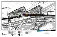
<strong>St<strong>at</strong>ion</strong> <strong>design</strong> <strong>issues</strong> <strong>raised</strong> <strong>at</strong> <strong>Green</strong> <strong>Line</strong> <strong>Extension</strong> <strong>Land</strong> <strong>Use</strong> WorkshopsBall Square<strong>Green</strong> space/landscaping• More greenery and open space for public g<strong>at</strong>herings/exhibits/music-art opportunities• More greenery, plantings, even vegetable gardens. Beauty• <strong>Land</strong>scapingBicycle facilities• More bike parking• Lots of sheltered bicycle parking (another comment points to this one and says “yeah!”)Access• Access to st<strong>at</strong>ion from both sides of Broadway. Don’t make people have to cross Broadway• Provide access via both sides of Broadway• Access from both sides of the street. Will make access much safer• Access under Broadway to the East/South• Pedestrian access from the east (crosswalks) seems very lacking• Why do I have to climb stairs if I am coming from Boston Avenue/Ball Square• Need to figure out good bike & ped access from all directions• Need to look <strong>at</strong> st<strong>at</strong>ion access from both sides of street (seamless)• Look <strong>at</strong> access from both sides of street and crosswalks (to/from east in particular)<strong>St<strong>at</strong>ion</strong> loc<strong>at</strong>ion• Build st<strong>at</strong>ion <strong>at</strong> the bridge to enable easier access from both sides of Broadway• Go underground• Why can’t the green line go underground, as opposed to above ground?Other• We want real input on st<strong>at</strong>ion and track <strong>design</strong> – it will affect our homes as direct abutters• A sound wall will cut off light to our property. 54 homes. How can we have input into the <strong>design</strong>process?• (Concerned about) Blending of new development with older brick buildings; reuse and enhancearchitectural elementsCollege AvenueSound barriers• Money for sound barriers- Need a line item dedic<strong>at</strong>ed to it in the budget.• Noise barrier wherever there is work• Sound barriers to be put up!? Along RR tracks?• Increased noise- sound barriers needed all along the wayBicycle facilities• Want bike lanes and covered bike parking <strong>at</strong>/around st<strong>at</strong>ion• More bicycle parkingTrees and green space• Wall=ugly without trees. Consider aesthetics• Will we have any trees left? This strip of trees near the tracks is a huge percentage of theneighborhood’s trees• Decking over tracks from College Ave to Winthrop, cre<strong>at</strong>e linear park aboveDrop off loc<strong>at</strong>ion• Loc<strong>at</strong>ion of “drop off” so close to Boston/College intersection- traffic is already so crazy there.Personally, I would prefer the sacrifice of parking spaces to move drop off down Boston Ave.
D<strong>at</strong>e:Project No.:3• Too much T parking in new plan• Where do the drivers park their cars when the 200-car lot is eventually taken over by priv<strong>at</strong>edevelopment and before th<strong>at</strong> development adds 200 parking spaces?Signage• Better signage• Better signage for pedestrians, Galleria, Registry of Deeds, etc.Visibility• <strong>St<strong>at</strong>ion</strong> too ‘invisible’ to the neighborhood• Proposed st<strong>at</strong>ion is completely hidden from existing neighborhood- where is the proposed 1980’shead house, which directly rel<strong>at</strong>ed to First Street axis? It is not part of neighborhood – how can youimprove this?Access• It can be dangerous going into Lechmere <strong>St<strong>at</strong>ion</strong> with buses coming in and existing in the same areaas pedestrians• Consider overpasses for pedestrian passage over McGr<strong>at</strong>h- the crosswalks are inefficient• Skywalk across the highway!• Footbridge over 28 to new st<strong>at</strong>ion?• Put the inlet bridge so people can walk thru the parks instead of on O’Brien. In the meantime, put acrosswalk <strong>at</strong> Charlestown Avenue/O’Brien before someone is killed• Is the <strong>design</strong> of crosswalks taking into account the possibility th<strong>at</strong> the extension will <strong>at</strong>tract pedestriansto the area? It does not appear to.• Must have safe, well-lit pedestrian walkway over O’Brien Highway in Cambridge (Lechmere)• Crosswalks on McGr<strong>at</strong>h Highway must have working walk lights (pedestrian only) and must beelev<strong>at</strong>edOther• Everything visually (could be improved), needs to be a positive urban visual landmark to EastCambridge neighborhood, multiple-use = safer <strong>at</strong> night• Safe and easy access, beautiful landmark, active area, quality welcoming and timeless <strong>design</strong> equal toanywhere else in the system, prominently visible• Well-lit, covered entries and waiting areas, lots of trash barrels and smoke/cigarette receptacles andempty them please!• Expand to be the 4-season MBTA st<strong>at</strong>ion• Design a st<strong>at</strong>ion th<strong>at</strong> faces the neighborhood, not the empty NorthPoint side• Save the historic bus shed• Remove billboardsLowell StreetBicycle facilities• Bike storage is crucial• Provide covered secure bike parking facilities with room for expansion• Bike bridge• Design community p<strong>at</strong>h and st<strong>at</strong>ion to promote connectivityAccess• Need access on both sides of street to the st<strong>at</strong>ion• Extend st<strong>at</strong>ion under Lowell street to allow access from both sides• Two entrances to st<strong>at</strong>ion• Extend pl<strong>at</strong>form under bridge so you can get to st<strong>at</strong>ion from either side without crossing Lowell StreetParking• Underground parking
D<strong>at</strong>e:Project No.:4• Limits on loading zone parkingOther• Widen bridge to make double-sided drop-off• Triangle park• Beauty: greenery, planting, vegetable gardens, benches to sit and talkGilman SquareAccess• Increase bike and pedestrian access to the south side of tracks• Provide walking bridge across track to south side of trains• (Want) Direct connection to high school/library/city hall• Consider passenger overpass to high school/library on School Street• Vertical connections to City Hall/High school very important• Direct connection from High School to st<strong>at</strong>ion (allow for future connections, even if not built now)• Needs School Street entrance, helps connect to busses on Highland Avenue and areas west• Connect st<strong>at</strong>ion from both east and west sides (Medford Street and School Street) to extend thest<strong>at</strong>ion’s reach by ¼ mile!Trash cans• More public trash receptacles for more foot traffic• Include public trash cansOther• Provide a covered bike parking facility th<strong>at</strong> has increased security via camera or other means• Do need a car passenger drop-off area – not parking, but a safe drop-off area (Sullivan Square not agood example)• Do not need more parking lotsUnion Square<strong>Green</strong> space• Since green space is <strong>at</strong> a premium, why not have a public roof garden above the st<strong>at</strong>ion? (Gre<strong>at</strong> idea!)• Street trees, shade trees, arbor; new series of linked parks; park revitalizes/heals toxic landscapeBicycle facilities• Sheltered bicycle parking for commuters – 5% of ridership• Covered bike shelter cages• Cover bicycle storagePossible expansion• <strong>St<strong>at</strong>ion</strong> <strong>design</strong> should be expandable• Must be built to allow extension to Porter Square, construct the st<strong>at</strong>ion longer to reach WebsterAvenue• Design for possible future expansion to Porter SquareCommunity amenities• Public art• Playground by school; performance space outdoors• History walk, public art• Sk<strong>at</strong>e park• Bocce, chess tables, intern<strong>at</strong>ional multi-ethnic game spaceAccess
D<strong>at</strong>e:Project No.:5• As mentioned in the discussion, more pedestrian access to the st<strong>at</strong>ion. I propose a pl<strong>at</strong>form extensionunder both bridges for access to Webster Avenue.• You must have safe pedestrian access to the st<strong>at</strong>ion from the west and north, ideally have aheadhouse on the west side of Prospect• Walking from Union Square to Union Square st<strong>at</strong>ion via Webster Street looks challenge. Will there bea pedestrian walkway along tracks? Otherwise, walk will be indirect• Badly need easy access on Union Square side of Webster, why doesn’t pl<strong>at</strong>form go on Union Squareside?• Rail and Pl<strong>at</strong>form accessible from Webster• Entrance/head house from both sides of Prospect• Headhouses on both sides of Prospect as well as on Webster• The st<strong>at</strong>ion should be loc<strong>at</strong>ed between Webster and Prospect so you can have dual points of entry. Asignificant portion of users will come down Webster, so access from Webster bridge is critical. East ofProspect is not accessible• <strong>St<strong>at</strong>ion</strong> needs to be visible on Webster Avenue, access from both sides of Prospect• Access to Brickbottom directly from st<strong>at</strong>ion• Can pedestrian access parallel sides of electrical subst<strong>at</strong>ion?• Cre<strong>at</strong>e a connection under Prospect Bridge to allow a cross to the west of Prospect without crossingProspect Street traffic• Maze of street network terrible for efficient pedestrian access. Suggestion – extra fare g<strong>at</strong>e <strong>at</strong> pl<strong>at</strong>formlevel leading to walkway in rail row to vertical connector <strong>at</strong> Webster Street Bridge. Similar to Route 16,no amenities (vending, etc), just a g<strong>at</strong>e would improve access to Union Square, Summer Street,Concord Square• Multiple entrances, new crosswalks/safe, g<strong>at</strong>eway to Union Square (<strong>Green</strong>way)• Pedestrian p<strong>at</strong>hway to Allen Street• Moving stairway and elev<strong>at</strong>ors to allow street-level entryBus connectivity/access• Build a busway on decking between Prospect and Webster (in front of the subst<strong>at</strong>ion) for bus accessto the st<strong>at</strong>ion• Can build cantilever over rail to provide bus access?• Plan for better bus connectivity as part of st<strong>at</strong>ion planning, not after it• Bus st<strong>at</strong>ion above tracks between Prospect and WebsterOther• When you’re building new sidewalks, lanes, etc, seek pervious paving options• Larger st<strong>at</strong>ion• Building should be “sign<strong>at</strong>ure”• N<strong>at</strong>ural light, energy efficiency, using impervious m<strong>at</strong>erials for w<strong>at</strong>er, solar powered lighting, green roof• Glass cover, timed he<strong>at</strong> lamps, shelter from we<strong>at</strong>her• Moving turnstiles to entry to allow sheltered wait• Safe, welcoming, <strong>at</strong>tractive spaces• No new parkingWashington Street/BrickbottomBicycle facilities• Bike racks, possible bike hotel• Provide covered, secure bike parking with ability to expand capacity as needed• Sheltered, ample bicycle parking for commuters<strong>St<strong>at</strong>ion</strong> visibility and loc<strong>at</strong>ion• Put the st<strong>at</strong>ion over Washington Street bridge, make st<strong>at</strong>ion very visible• Improve st<strong>at</strong>ion visibility – current st<strong>at</strong>ion is too hidden• Move st<strong>at</strong>ion over Washington Street. Keep Community P<strong>at</strong>h on west side of tracks to reach st<strong>at</strong>ionand Brickbottom
D<strong>at</strong>e:Project No.:6• Visibility of st<strong>at</strong>ion (noted twice)Lighting and signage• Better street/pedestrian lighting around st<strong>at</strong>ion area• Lighting• Signage to the st<strong>at</strong>ionAccess• Pedestrian connectivity – st<strong>at</strong>ion <strong>design</strong> will make or break it• Work out pedestrian access from both zones of Inner Belt. Do long range planning to improvebike/pedestrian crossings of McGr<strong>at</strong>h corridor• Get WalkBoston and pedestrian <strong>design</strong>ers involved, access is poor and must be improved• Entire pedestrian area approaching the st<strong>at</strong>ion needs to be improved – cleanliness, lighting, surfacemaintenance and pedestrian crossings for Washington Street and McGr<strong>at</strong>h Highway• Vertical connections between community p<strong>at</strong>h and st<strong>at</strong>ion needed• Wheel chair accessOther• More green areas• Move drop off to north side, with signal <strong>at</strong> Tufts Street• Noise barriers• Bus drop-off close to st<strong>at</strong>ionMaintenance FacilityStorage• Enclose storage yards• Train storage is noisiest and most noxious part, buffer it from neighborhood• Minimize vehicle storage <strong>at</strong> Brickbottom end of option L area to avoid more impacts• The train storage under the North Point Bridge cre<strong>at</strong>es elev<strong>at</strong>ion problems (grades). No train storageshould block a future bridge corridor.Parking and footprint• Move parking lots to other side of BET to reduce land takings• Share land (especially parking) with BET• Smaller footprint• Shift footprint to B.E.T.• Can maintenance yard footprint be moved closer to B.E.T. to not cut off future economicdevelopment?• Push activity as far away from residents as possible<strong>Green</strong> <strong>design</strong>• Design it as green as possible• Make green roofs over some storage tracks to increase green space in SomervilleOther• Sound and sight walls around facility• A bridge from Inner Belt to North Point essential. It combines with Community P<strong>at</strong>h and serves bothCambridge and Somerville• Reduce land takings, <strong>design</strong> as compact as possible• Design observ<strong>at</strong>ion deck/”museum” component• Improve <strong>design</strong> re: street grid connectivity (East Cambridge, etc)Route 16Access/connectivity• Connectivity to west Medford Square needed
D<strong>at</strong>e:Project No.:7• Connectivity to grocery store is needed, will be important• Don’t forget connections north and east (ex. Condon H<strong>at</strong> Shell)• Walk & bike connections (ex. Mystic Lakes)• Concourse under tracks (embankment) to connect to Whole Foods area• Study the potential pedestrian connection to North Street• Strengthen connection to public housing via park (Irvington Road)Other• Cre<strong>at</strong>e park on opposite side of U-haul building• Additional parking decks for new housing/businesses• Include signage for Mystic Lakes, especially for bicyclists• Transit-access to green space – unique!• Include parallel multi-use p<strong>at</strong>h along tracks to West Medford from Route 16 <strong>St<strong>at</strong>ion</strong>