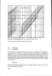
4. THE INTERPRETATION OF SOIL SURVEYS FOR PRACTICAL ...
4. THE INTERPRETATION OF SOIL SURVEYS FOR PRACTICAL ...
4. THE INTERPRETATION OF SOIL SURVEYS FOR PRACTICAL ...

Create successful ePaper yourself
Turn your PDF publications into a flip-book with our unique Google optimized e-Paper software.
APPENDIXAERIAL PHOTOGRAPHY <strong>FOR</strong> <strong>SOIL</strong> SURVEY PROJECTSGENERAL TENTATIVE OUTLINE, SUBJECT TO VARIATIONS ; BASED ON DRAFT SPECIFICATIONSMADE BY F. L. CORTEN AND A. P. A. VINKCamera typeWide-angle camera (i.e. f = 11 ... 12 cm for 18 x 18 cm image size; f = 15 cm (6”) for24 x 24 cm (9” x 9”) image size) if the terrain elevations per model are not more than10 % ... 15 % of the flying height.Normal-angle camera (i.e. f = 20 cm for I8 x 18 cm immage size; f = 9” for 9” x 9”image size) if terrain elevations more than 15 % of the flying height do occur in one model.Either wide-angle or normal angle where terrain elevations are of the order of 10%H... 15% H.Flight planAccording to the boundaries of the main physiographic units but as far as possible eastwestfight lines. East-west flight lines are certainly recommended if no definite preferenceaccording to physiography can be shown. Photo scale preferably 1 : 20.000 with respect tomean datum. (Photo scale alternatively between 1 : 25.000 and maximum 1 :15.000). Timeof flight: preferably in such a season that the significant soil conditions and the differencesin vegetation types, show up as far as possible in the photographs with maximum tonalcontrast.In the case of reconnaissance soil surveys smaller scales, up to approximately 1 : 70.000may be used. In this case the use of a super-wide-angle camera should be considered.East-west flight lines are recommended.50