An old ânewâ gas reservoir in Pennsylvania - Penn State Marcellus ...
An old ânewâ gas reservoir in Pennsylvania - Penn State Marcellus ...
An old ânewâ gas reservoir in Pennsylvania - Penn State Marcellus ...

Create successful ePaper yourself
Turn your PDF publications into a flip-book with our unique Google optimized e-Paper software.
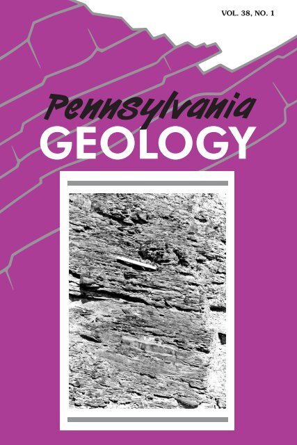
COMMONWEALTH OF PENNSYLVANIAEdward G. Rendell, GovernorDEPARTMENT OF CONSERVATION AND NATURAL RESOURCESMichael DiBerard<strong>in</strong>is, SecretaryOFFICE OF CONSERVATION AND TECHNICAL SERVICESC<strong>in</strong>dy Adams Dunn, Deputy SecretaryBUREAU OF TOPOGRAPHIC AND GEOLOGIC SURVEYJay B. Parrish, DirectorBureau web site: www.dcnr.state.pa.us/topogeoDCNR web site: www.dcnr.state.pa.us<strong><strong>Penn</strong>sylvania</strong> home page: www.state.pa.usCONTENTSShale we look for <strong>gas</strong>?............................................................................. 1The <strong>Marcellus</strong> shale—<strong>An</strong> <strong>old</strong> “new” <strong>gas</strong> <strong>reservoir</strong> <strong>in</strong> <strong><strong>Penn</strong>sylvania</strong> ............ 2Meet the staff—Part 6 .............................................................................. 13New releases—Sixteen new open-file reports now onl<strong>in</strong>e........................ 17In memoriam—Donald T. Hoff.................................................................. 19<strong>An</strong>nouncement—73rd Field Conference of <strong><strong>Penn</strong>sylvania</strong> Geologists ...... 20ON THE COVER<strong>An</strong> outcrop of the <strong>Marcellus</strong> shale (see article on page 2), located about 1.8miles southeast of Milton, Pa. The scale is about 6 <strong>in</strong>ches long. Photographby Jon D. Inners (Inners, J. D., 1997, Geology and M<strong>in</strong>eral Resources of theAllenwood and Milton Quadrangles, Union and Northumberland Counties,<strong><strong>Penn</strong>sylvania</strong>: <strong><strong>Penn</strong>sylvania</strong> Geological Survey, 4th ser., Atlas 144cd, p. 37).PENNSYLVANIA GEOLOGYPENNSYLVANIA GEOLOGY is published quarterly by the Bureau of Topographic andGeologic Survey, <strong><strong>Penn</strong>sylvania</strong> Department of Conservation and Natural Resources, 3240Schoolhouse Road, Middletown, PA 17057–3534.Editors: <strong>An</strong>ne B. Lutz and Caron E. O’Neil.Contributed articles are welcome. Guidel<strong>in</strong>es for manuscript preparation may be obta<strong>in</strong>edat www.dcnr.state.pa.us/topogeo/pub/pageolmag/pageolguide.aspx or by contact<strong>in</strong>g theeditors at the address listed above.VOL. 38, NO. 1 SPRING 2008ERRATUM: On page 7 of the previous issue (<strong><strong>Penn</strong>sylvania</strong> Geology, v. 37, no. 3/4), <strong>in</strong> thefirst entry of the explanation for Figure 3, the contour <strong>in</strong>terval should be 6 <strong>in</strong>ches.
STATE GEOLOGIST’S EDITORIALShale We Look For Gas?Recently, you may have noticed articles <strong>in</strong> the popular press aboutthe abundant riches of <strong>gas</strong> beneath our feet <strong>in</strong> <strong><strong>Penn</strong>sylvania</strong>, thanksto the <strong>Marcellus</strong> shale. Although the <strong>Marcellus</strong> will probably not bequite as productive as the hype suggests, there is not enough available<strong>in</strong>formation to fully evaluate its potential. We often are t<strong>old</strong> thatthe United <strong>State</strong>s has plenty of oil and <strong>gas</strong> if only pesky environmentalrestrictions could be removed and we could drill <strong>in</strong> Alaska. Butpeak petroleum production for the United <strong>State</strong>s is past. We can f<strong>in</strong>dand produce more, but we are on the downward curve. Even coal,which we have always been taught could keep us warm for hundredsof years, is <strong>in</strong> shorter supply than we previously thought. The easystuff (thick beds of Pittsburgh coal) is quickly be<strong>in</strong>g m<strong>in</strong>ed. In addition,<strong>in</strong>ternational demand is <strong>in</strong>creas<strong>in</strong>g.<strong><strong>Penn</strong>sylvania</strong> is, however, faced with another, different k<strong>in</strong>d of opportunity.Rather than produc<strong>in</strong>g fossil fuels, we might be able to disposeof waste CO 2(the process of carbon sequestration), because wehave even more capacity for stor<strong>in</strong>g waste <strong>gas</strong>es than we do for provid<strong>in</strong>gthe coal that produces the waste <strong>gas</strong>es. The topic of carbonsequestration was addressed <strong>in</strong> a previous issue of this magaz<strong>in</strong>e(<strong><strong>Penn</strong>sylvania</strong> Geology, v. 34, no. 2, p. 2–9). Here at the Survey wehope to focus much of our energy <strong>in</strong> the next few years mapp<strong>in</strong>g thecarbon sequestration potential of the easternportion of the state, as well as look<strong>in</strong>gat those all-important water resources. All<strong>in</strong> all, it should be a busy time for us. <strong>An</strong>dwith oil at more than $100 per barrel andg<strong>old</strong> at around $1,000 per ounce, it is anexcit<strong>in</strong>g time to be a geologist.Jay B. Parrish<strong>State</strong> Geologist
The <strong>Marcellus</strong> Shale—<strong>An</strong> Old “New”Gas Reservoir <strong>in</strong> <strong><strong>Penn</strong>sylvania</strong>by John A. HarperBureau of Topographic and Geologic SurveyWHAT’S ALL THE FUSS? Black, organic-rich shales are common constituentsof sedimentary deposits formed throughout geologic time.In <strong><strong>Penn</strong>sylvania</strong>, black, organic-rich shales can be found <strong>in</strong> almost allof the Paleozoic systems, as well as <strong>in</strong> the Triassic rocks of the Newarkand Gettysburg bas<strong>in</strong>s <strong>in</strong> the southeast. Some of these shalesare the sources of the crude oil and natural <strong>gas</strong> found <strong>in</strong> <strong><strong>Penn</strong>sylvania</strong>’ssandstone and carbonate <strong>reservoir</strong>s. One shale unit <strong>in</strong> particular,the Middle Devonian <strong>Marcellus</strong> Formation (see front cover), hasrecently become a hot item with the nation’s oil and <strong>gas</strong> <strong>in</strong>dustry, aswell as with the news media. One would th<strong>in</strong>k, from all the fuss aboutthe <strong>Marcellus</strong>, that it was a newly discovered <strong>gas</strong> <strong>reservoir</strong> conta<strong>in</strong><strong>in</strong>genough <strong>gas</strong> to susta<strong>in</strong> America’s needs for decades. In reality, the<strong>Marcellus</strong> has been a known <strong>gas</strong> <strong>reservoir</strong> for more than 75 years.What has made it newsworthy, besides much hyperbole, is that theoil and <strong>gas</strong> <strong>in</strong>dustry has both new technology and price <strong>in</strong>centives thatmake this otherwise difficult <strong>gas</strong> play economical.FIRST, SOME HISTORY. Natural <strong>gas</strong> has been part of our heritagefor more than 200 years. Gas, along with crude oil, was found <strong>in</strong> numerouswells dug or drilled for salt water <strong>in</strong> colonial times. The firstwell drilled specifically to produce natural <strong>gas</strong> <strong>in</strong> North America wascompleted <strong>in</strong> Devonian shales. Citizens of Fredonia, N. Y., noticed<strong>gas</strong> bubbl<strong>in</strong>g up through the bed of Canadaway Creek, and someonehad the foresight to s<strong>in</strong>k a well to collect the <strong>gas</strong> and use it tolight the town <strong>in</strong> 1821, 38 years before Drake drilled his famous oilwell at Titusville, Pa. The Fredonia well was only 27 feet deep, but itproduced enough <strong>gas</strong> to provide the light equivalent of “two goodcandles.” In 1850, the well was deepened to 70 feet and producedenough <strong>gas</strong> to light 200 burners. In 1858, a second well was drilledto more than 200 feet, and the <strong>gas</strong> lasted another 30 to 35 years.As a result of the Fredonia wells, a flurry of drill<strong>in</strong>g activity commencedalong the Lake Erie shorel<strong>in</strong>e, eventually reach<strong>in</strong>g at least asfar as Sandusky, Ohio. The <strong>gas</strong> came from black, organic-rich shales2
and from fractured shales and siltstones above and <strong>in</strong>terbedded withthe black shales. Typically, the wells were 1,000 feet deep or less,and many were produc<strong>in</strong>g from as shallow as 25 or 30 feet. By thebeg<strong>in</strong>n<strong>in</strong>g of the twentieth century, just about every backyard andmanufactur<strong>in</strong>g plant with<strong>in</strong> a mile of the Lake Erie shore <strong>in</strong> <strong><strong>Penn</strong>sylvania</strong>had at least one <strong>gas</strong> well that kept the house or bus<strong>in</strong>ess reasonablywell lighted and heated. The wells had unreliable pressuresthat varied with changes <strong>in</strong> the weather—when a c<strong>old</strong> front camethrough, it was time to break out the wood stove. However, the wellsseemed to last forever. Many of the backyard wells drilled <strong>in</strong> theearly part of the twentieth century are still provid<strong>in</strong>g <strong>gas</strong> to residentsof Erie County.In the 1930s, the oil and <strong>gas</strong> <strong>in</strong>dustry began f<strong>in</strong>d<strong>in</strong>g large commercialquantities of natural <strong>gas</strong> <strong>in</strong> the Lower Devonian Oriskany Sandstone<strong>in</strong> New York and <strong><strong>Penn</strong>sylvania</strong>. As companies were drill<strong>in</strong>g tothis target, their wells penetrated the black shales of the <strong>Marcellus</strong>Formation, situated a few tens to a few hundreds of feet above theOriskany. Just about every well had a strong flow of <strong>gas</strong> that shutdown drill<strong>in</strong>g for several days. The <strong>Marcellus</strong> fasc<strong>in</strong>ated the <strong>in</strong>dustryuntil it became clear that the <strong>gas</strong> occurred <strong>in</strong> “pockets” and that theflows could not be susta<strong>in</strong>ed. These <strong>gas</strong> flows died down quickly, andthe drillers soon began to ignore them when they encountered them.Everyone knew there was <strong>gas</strong> <strong>in</strong> the <strong>Marcellus</strong>, but the consensuswas that there was not enough to make a well.Follow<strong>in</strong>g the energy crisis of 1973, the onset of energy shortagesand the subsequent <strong>in</strong>crease <strong>in</strong> natural <strong>gas</strong> prices spurred theU.S. Department of Energy to fund a multistate cooperative programcalled the Eastern Gas Shales Project (EGSP) that spanned the Appalachian,Ill<strong>in</strong>ois, and Michigan bas<strong>in</strong>s. The two purposes of the projectwere to determ<strong>in</strong>e the extent, thickness, structural complexity, andstratigraphic equivalence of all Devonian organic-rich shales throughoutthe bas<strong>in</strong>s; and to develop and implement new drill<strong>in</strong>g, stimulation,and recovery technologies to <strong>in</strong>crease production potential. Geologicalteams correlated and mapped the rocks; geophysical teamsworked on new technologies to locate fracture systems and potential<strong>reservoir</strong>s; geochemical teams <strong>in</strong>vestigated ways to modify theshale matrix to <strong>in</strong>crease <strong>gas</strong> flow; eng<strong>in</strong>eer<strong>in</strong>g teams derived andtested models of various fractur<strong>in</strong>g techniques and directional drill<strong>in</strong>gprocedures; and oil and <strong>gas</strong> companies drilled and cored numeroustest wells <strong>in</strong> each of the states <strong>in</strong>volved <strong>in</strong> the project. Five wellswere drilled <strong>in</strong> <strong><strong>Penn</strong>sylvania</strong> (Figure 1), and cores were collected of3
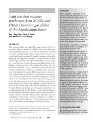
Figure 1. Map show<strong>in</strong>g the general distribution of the <strong>Marcellus</strong> Formation <strong>in</strong><strong><strong>Penn</strong>sylvania</strong>. Also shown are the locations of five wells drilled and cored dur<strong>in</strong>gthe Eastern Gas Shales Project (EGSP) study of the 1970s and 1980s. Orientationsof measured fractures are shown (fracture data from Evans, 1994).the Devonian shales <strong>in</strong> each that provided a wealth of data about bedd<strong>in</strong>g,m<strong>in</strong>eralogy, fracture systems, and so forth.I was part of the <strong><strong>Penn</strong>sylvania</strong> Geological Survey team that spentseveral years do<strong>in</strong>g basic mapp<strong>in</strong>g and correlation. The end products<strong>in</strong>cluded numerous cross sections, maps, and technical reports(e.g., Piotrowski and Harper, 1979) show<strong>in</strong>g formation thickness, netfeet of organic-rich shales, and net feet of clean sandstone throughoutthe entire Middle and Upper Devonian sequence <strong>in</strong> western andnorth-central <strong><strong>Penn</strong>sylvania</strong>. We determ<strong>in</strong>ed that the Devonian organicrichshales could be important <strong>gas</strong> <strong>reservoir</strong>s, at least <strong>in</strong> northwestern<strong><strong>Penn</strong>sylvania</strong> where they were both thick and close to the surface.These shales were thought to have excellent potential to fill theneeds of users, especially if the expected development of better technologyfor <strong>in</strong>duc<strong>in</strong>g and enhanc<strong>in</strong>g fracture systems that is so importantto susta<strong>in</strong> production <strong>in</strong> shale came about. The deeper shales,4
particularly the <strong>Marcellus</strong> Formation, were considered to be muchless attractive targets and would rema<strong>in</strong> so until <strong>gas</strong> prices <strong>in</strong>creasedand technology advanced enough to make drill<strong>in</strong>g and completioncompetitive with more conventional targets. Neither occurred untilrecently.The furor over the Devonian shales faded dur<strong>in</strong>g the early 1980sdue to low <strong>gas</strong> prices and lack of sufficiently useful technologies forextract<strong>in</strong>g the <strong>gas</strong>. The complete EGSP library, which has rema<strong>in</strong>edrelatively obscure because of the lack of <strong>in</strong>terest, is quite extensiveand <strong>in</strong>cludes a wealth of physical, chemical, geological, and eng<strong>in</strong>eer<strong>in</strong>g<strong>in</strong>formation. Much of it can be found <strong>in</strong> the National EnergyTechnology Laboratory’s compendium of natural <strong>gas</strong> archives (NationalEnergy Technology Laboratory, 2007), which is available at nocost from the U.S. Department of Energy. In addition, summaries havebeen published over the years, such as that by Roen and Kepferle(1993), which provide very useful <strong>in</strong>formation on the shales. <strong>An</strong>yone<strong>in</strong>terested <strong>in</strong> f<strong>in</strong>d<strong>in</strong>g out more about Devonian shales as <strong>gas</strong> <strong>reservoir</strong>sshould consult these publications.With<strong>in</strong> the last three to four years, as a result of a comb<strong>in</strong>ationof higher prices, recent technological advances, and the developmentof large <strong>gas</strong> resources from black shales <strong>in</strong> other parts of thecountry, the <strong>in</strong>terest <strong>in</strong> <strong><strong>Penn</strong>sylvania</strong>’s organic-rich shales has risenonce aga<strong>in</strong> to a fever pitch with<strong>in</strong> the state’s oil and <strong>gas</strong> <strong>in</strong>dustry.This is particularly true for the <strong>Marcellus</strong> Formation, which lies beneathmuch of <strong><strong>Penn</strong>sylvania</strong> (Figure 1). Some companies are pay<strong>in</strong>g<strong>in</strong>credible fees for leases, while others are spend<strong>in</strong>g enormousamounts of money to drill <strong>Marcellus</strong> <strong>gas</strong> wells across the state, fromGreene County <strong>in</strong> the southwest to Wayne County <strong>in</strong> the northeast.All of this activity has been excit<strong>in</strong>g the press, landowners, and stateand municipal authorities, who look upon the <strong>Marcellus</strong> as a majoreconomic boon for <strong><strong>Penn</strong>sylvania</strong>.RADIOACTIVITY = ORGANIC RICHNESS = GAS. The oil and <strong>gas</strong><strong>in</strong>dustry uses a number of geophysical logg<strong>in</strong>g tools to characterizethe subsurface rocks. The most commonly run logg<strong>in</strong>g tool <strong>in</strong> the Appalachianbas<strong>in</strong>, the gamma-ray log, is a very sensitive Geiger counterthat measures the natural low-level radioactivity <strong>in</strong>herent <strong>in</strong> almostall sedimentary rocks. Most of the radiation emitted by these rocksis due to the radioactive potassium isotope (potassium-40) found <strong>in</strong>feldspars, micas, clay m<strong>in</strong>erals, and other common and abundantsilicate m<strong>in</strong>erals. On gamma-ray logs, shales can be differentiated5
from other rocks such as clean sandstones and limestones becauseshales have higher concentrations of potassium-40-bear<strong>in</strong>g m<strong>in</strong>erals.Organic-rich shales have higher radioactivity responses than typicalshales because the organic matter tends to concentrate uraniumions that otherwise would be scattered throughout the sediment (Adamsand Weaver, 1958; Schmoker, 1981). As a result, many organic-richshales have uranium and thorium contents that are greater than 10parts per million and that may approach 100 parts per million, whichwill show up on a gamma-ray log as higher-than-normal gamma-rayresponses (Figure 2). Comparisons of gamma-ray logs with drill cutt<strong>in</strong>gsshow a fairly strong correlation between higher-than-normal radioactivityand black color <strong>in</strong> shales, derived from the organic content.To put it simply, black coloration generally correlates with organic richness,which correlates with high gamma-ray response.The ic<strong>in</strong>g on the cake, so to speak, was the number of studiesdone dur<strong>in</strong>g and after EGSP that <strong>in</strong>dicated an empirical relationshipbetween high gamma-ray response and both <strong>gas</strong> production and total<strong>gas</strong> content <strong>in</strong> organic-rich shales. In other words, higher-thannormalgamma-ray response also equates to <strong>gas</strong>-production potential.The correlation might not be 100 percent, but it is very high. Thisis a very important concept for those look<strong>in</strong>g to produce shale <strong>gas</strong>.Many companies would look for places where the entire formation isthick, but they should actually be look<strong>in</strong>g for where it is most rich <strong>in</strong>organic matter. When we mapped the Devonian formations dur<strong>in</strong>gEGSP, we created maps show<strong>in</strong>g the net feet of shale hav<strong>in</strong>g higherthan-normalradioactive signatures on gamma-ray logs (equivalent tonet feet of organic-rich shale) (e.g., see back cover). It is my beliefthat these maps are far more accurate for f<strong>in</strong>d<strong>in</strong>g good sources ofnatural <strong>gas</strong> than just mapp<strong>in</strong>g formation thickness.THE MEEK SHALE INHERIT THE EARTH. The Devonian shales <strong>in</strong><strong><strong>Penn</strong>sylvania</strong> occur at and near the base of a thick sequence of <strong>in</strong>tercalatedmar<strong>in</strong>e, transitional, and cont<strong>in</strong>ental rocks known as theCatskill clastic wedge. This sequence is more than 10,000 feet thick<strong>in</strong> eastern <strong><strong>Penn</strong>sylvania</strong> but th<strong>in</strong>s to about 2,000 feet along the LakeErie shorel<strong>in</strong>e (Colton, 1970). <strong><strong>Penn</strong>sylvania</strong>’s thick sequence of Devonianshales can be divided <strong>in</strong>to organic-rich black shale facies andnot-so-organic-rich gray shale and siltstone facies (Figure 2). Thissequence is capped by the sandstone-rich portion of the Upper Devonianthat has been the “bread and butter” of the oil and <strong>gas</strong> <strong>in</strong>dustry<strong>in</strong> this state for 150 years.6
Figure 2. Correlation of Middle and Upper Devonian organic-rich shale faciesand <strong>in</strong>terbedded strata <strong>in</strong> three wells <strong>in</strong> <strong><strong>Penn</strong>sylvania</strong>, based on gamma-ray logsignatures (the jagged purple l<strong>in</strong>es) and descriptions of well cutt<strong>in</strong>gs. Note thatthe black shales correspond <strong>in</strong> large part to higher-than-normal gamma-rayread<strong>in</strong>gs (radioactivity <strong>in</strong>creases to the right <strong>in</strong> all log signatures).The three most important organic-rich shales <strong>in</strong>clude the blackshale facies of the Middle Devonian <strong>Marcellus</strong> Formation and of theUpper Devonian West Falls Formation and Ohio Shale (the Rh<strong>in</strong>estreetand Huron facies, respectively) (Figures 2 and 3). All have beenexplored at one time or another as natural <strong>gas</strong> <strong>reservoir</strong>s. Three less7
Figure 3. Distribution of the thickest sequences of organic-rich shale <strong>in</strong> theOhio Shale, West Falls Formation, and Hamilton Group (Huron, Rh<strong>in</strong>estreet, and<strong>Marcellus</strong> facies, respectively) (based on Piotrowski and Harper, 1979, andHarper and Abel, 1980).important units <strong>in</strong>clude the Upper Devonian Harrell (and partiallyequivalent Genesee), Sonyea, and Java Formations (Figure 2). Allof the organic-rich shales, plus the associated gray shales and siltstonesthat overlie and <strong>in</strong>tercalate with them, participate as the <strong>reservoir</strong>for the shale-<strong>gas</strong> production along the marg<strong>in</strong> of Lake Erie. Asystem of fractures <strong>in</strong> these shales constitutes the most important partof the <strong>reservoir</strong> by provid<strong>in</strong>g porosity and permeability that allows the<strong>gas</strong> to leak slowly from the rock.QUO VADIS, MARCELLUS? The <strong>Marcellus</strong> Formation underlies mostof <strong><strong>Penn</strong>sylvania</strong> (Figure 1), but the organic-rich portion reaches itsmaximum development <strong>in</strong> the northeastern part of the state (see backcover). Despite the long history of <strong>gas</strong> shows <strong>in</strong> the <strong>Marcellus</strong>, it tookuntil recently for its potential as a commercial <strong>gas</strong> target to attract attention.By standard def<strong>in</strong>ition for mapp<strong>in</strong>g purposes, the <strong>Marcellus</strong> Formation<strong>in</strong> <strong><strong>Penn</strong>sylvania</strong> typically is def<strong>in</strong>ed as the black shales at the8
ase of the Middle Devonian Hamilton Group; the upper part of thegroup is occupied by gray and dark-gray shales, siltstones, and (tothe east) sandstones of the Mahantango Formation (Figure 2). Theorganic richness (i.e., the black coloration) with<strong>in</strong> the Hamilton Group<strong>in</strong> the subsurface varies from place to place so that the <strong>Marcellus</strong>/Mahantango boundary fluctuates. Piotrowski and Harper (1979, Plate3) showed that the Hamilton Group as a whole thickens fairly regularlyfrom northwest to southeast. However, the net feet of higherthan-normalradioactive shale <strong>in</strong> the Hamilton Group—the <strong>Marcellus</strong>facies—has an <strong>in</strong>terest<strong>in</strong>g configuration (Piotrowski and Harper, 1979,Plate 4). The <strong>Marcellus</strong> generally thickens to the east, as expected,but throughout the eastern half of the Appalachian Plateaus physiographicprov<strong>in</strong>ce as far north as Tioga County, it also develops <strong>in</strong>toa series of l<strong>in</strong>ear thick areas situated on the crests of anticl<strong>in</strong>es (seeback cover). Some of this thicken<strong>in</strong>g can be expla<strong>in</strong>ed by repetitionof the section through fault<strong>in</strong>g, but close correlation of logs alongand across the anticl<strong>in</strong>es also <strong>in</strong>dicates that, for some reason, moreof the Hamilton Group rock section becomes organic rich over thesestructures.<strong><strong>Penn</strong>sylvania</strong>’s <strong>Marcellus</strong> shale play began <strong>in</strong> 2003, when RangeResources–Appalachia, LLC (formerly Great Lakes Energy Partners,LLC) drilled a well to the Lower Silurian Rochester Shale <strong>in</strong> Wash<strong>in</strong>gtonCounty. The deep formations (such as the Oriskany Sandstoneand the Lockport Dolomite) did not look favorable, but the <strong>Marcellus</strong>shale had some promise. Range drilled some additional wells, andthrough experimentation with drill<strong>in</strong>g and hydraulic fractur<strong>in</strong>g techniquesborrowed and revised from those used on the MississippianBarnett Shale <strong>gas</strong> play <strong>in</strong> Texas, began produc<strong>in</strong>g <strong>Marcellus</strong> <strong>gas</strong> <strong>in</strong>2005. S<strong>in</strong>ce then, the company has permitted more than 150 <strong>Marcellus</strong>wells <strong>in</strong> Wash<strong>in</strong>gton County alone. Other companies have jo<strong>in</strong>edthe fray with permitt<strong>in</strong>g and drill<strong>in</strong>g <strong>in</strong> many areas of the AppalachianPlateaus <strong>in</strong> <strong><strong>Penn</strong>sylvania</strong>. As of the end of 2007, more than 375 suspected<strong>Marcellus</strong> wells had been permitted <strong>in</strong> <strong><strong>Penn</strong>sylvania</strong>. <strong>An</strong> additional78 had been permitted as of this writ<strong>in</strong>g (end of February,2008). Therefore, it appears that the <strong>Marcellus</strong> <strong>gas</strong> play will cont<strong>in</strong>ueuntil and unless <strong>gas</strong> prices fall dramatically.IT’S ALL ABOUT THE FRACTURES. Conventional <strong>gas</strong> <strong>reservoir</strong>s,such as the Lower Devonian Oriskany Sandstone, conta<strong>in</strong> <strong>gas</strong> <strong>in</strong> porespaces between the sand gra<strong>in</strong>s. The <strong>gas</strong> migrated <strong>in</strong>to the rock fromone or more source rocks dur<strong>in</strong>g the Alleghanian orogeny about 250million years ago. Organic-rich shales, however, are their own sourcerocks, and <strong>gas</strong> molecules generated from the organic matter adsorb9
onto the organic matrix of the rock. Over time, with the developmentof fractures of all sizes and orientations (Figure 1) due to a varietyof tectonic and hydraulic stresses, some of the <strong>gas</strong> desorbed fromthe matrix and migrated <strong>in</strong>to these fractures. It was these pockets of<strong>gas</strong> that the early drillers tapped. Because desorption takes placerelatively slowly, the fractures could not be refilled quickly enough toma<strong>in</strong>ta<strong>in</strong> a constant flow, so drill<strong>in</strong>g cont<strong>in</strong>ued past this potential <strong>reservoir</strong>and commercial quantities were found <strong>in</strong> deeper conventional<strong>reservoir</strong>s. The natural fractures are neither numerous nor extensiveenough to ma<strong>in</strong>ta<strong>in</strong> production except <strong>in</strong> certa<strong>in</strong> areas of Kentucky,West Virg<strong>in</strong>ia, Ohio, and along the Lake Erie shore.S<strong>in</strong>ce the early 1960s, <strong><strong>Penn</strong>sylvania</strong>’s oil and <strong>gas</strong> <strong>in</strong>dustry hasused hydraulic fractur<strong>in</strong>g (frac<strong>in</strong>g, pronounced “frack<strong>in</strong>g”) to enhancethe recovery of oil and natural <strong>gas</strong>. This <strong>in</strong>volves pump<strong>in</strong>g a fluidsuch as water or kerosene and, usually, sand or some other granularmaterial <strong>in</strong>to the produc<strong>in</strong>g formation under high pressure untilthe rock cracks. The process enhances the porosity and permeabilityof the rock, and the granular material (the propant) serves to propopen the newly created fractures. As a result, the surface area of therock <strong>in</strong>creases, allow<strong>in</strong>g <strong>gas</strong> to travel more readily from the pores tothe well bore.Shales are different than conventional hydrocarbon <strong>reservoir</strong>s.They have extremely low permeabilities and do not accept frac jobsas readily. Dur<strong>in</strong>g EGSP, petroleum eng<strong>in</strong>eers modeled many typesof frac jobs try<strong>in</strong>g to f<strong>in</strong>d the right comb<strong>in</strong>ation of fluids, propants, andpressures to maximize production <strong>in</strong> shales. But it was not until developmentof the Barnett Shale play <strong>in</strong> the 1990s that a techniquesuitable for frac<strong>in</strong>g shales was developed. This technique is called a“slick-water frac” and consists of sand and very large volumes offreshwater that has been treated with a friction reducer such as a gel.Slick-water fracs maximize the length of the fractures horizontallywhile m<strong>in</strong>imiz<strong>in</strong>g the vertical fracture height, result<strong>in</strong>g <strong>in</strong> greater <strong>gas</strong>mobility and more efficient recovery of a larger volume of the <strong>gas</strong>.<strong>An</strong>other technique that has become useful <strong>in</strong> produc<strong>in</strong>g <strong>Marcellus</strong><strong>gas</strong> is horizontal drill<strong>in</strong>g. The first horizontal well was drilled <strong>in</strong>Texas <strong>in</strong> 1929, but it took until the 1980s for the technology to be improvedenough to become a standard <strong>in</strong>dustry practice. The technology<strong>in</strong>volves drill<strong>in</strong>g a vertical hole to several hundred feet above thetarget <strong>reservoir</strong>, then direct<strong>in</strong>g the drill bit through an arc until it is literallydrill<strong>in</strong>g sideways <strong>in</strong>stead of downward (Figure 4). This has severaladvantages: (1) it <strong>in</strong>creases the amount of <strong>reservoir</strong> penetrated10
Figure 4. A comparison between a horizontal well and a typical vertical welldrilled to the <strong>Marcellus</strong> organic-rich shales. The horizontal well has the advantagesof turn<strong>in</strong>g a relatively th<strong>in</strong> <strong>reservoir</strong> <strong>in</strong>to a very thick one, and of be<strong>in</strong>g certa<strong>in</strong>to <strong>in</strong>tersect a larger number of fractures. The <strong>in</strong>set map shows a hypotheticallease and the two wells. Note that this map shows the locations of both thetop and bottom of the horizontal well and the course and distance between them.from perhaps a few tens of feet to as much as 3,000 or 4,000 feet;(2) it <strong>in</strong>creases the number of fractures penetrated; and (3) it can beused to develop hydrocarbon resources beneath sensitive areas suchas wetlands and cities where a drill<strong>in</strong>g rig cannot be set up. A slickwaterfrac <strong>in</strong> a vertical <strong>Marcellus</strong> well uses from 500,000 to more than1,000,000 gallons of water (a typical sandstone frac job uses only about11
5,000 to 50,000 gallons). A slick-water frac <strong>in</strong> a horizontal <strong>Marcellus</strong>well will probably use several million gallons of water. Based on <strong>in</strong>formationfrom the Barnett Shale play, a horizontal well completionmight use more than 3 million gallons (so far, I have not seen a wellrecord <strong>in</strong>volv<strong>in</strong>g a horizontal shale completion <strong>in</strong> <strong><strong>Penn</strong>sylvania</strong>).BUT IS IT REALLY WORTH IT? Dur<strong>in</strong>g EGSP, the U.S. GeologicalSurvey estimated that the <strong>Marcellus</strong> conta<strong>in</strong>s about 295 trillion cubicfeet (Tcf) of <strong>gas</strong>-<strong>in</strong>-place <strong>in</strong> the Appalachian bas<strong>in</strong> (Charpentier andothers, 1993). Figur<strong>in</strong>g a recovery of 3 to 5 percent, that means 9 to15 Tcf is recoverable throughout the bas<strong>in</strong>. Briggs and Tatlock (1999)assessed <strong><strong>Penn</strong>sylvania</strong>’s natural <strong>gas</strong> resources and estimated thatthe Devonian shales could potentially produce 8.4 Tcf with<strong>in</strong> the state,which is <strong>in</strong> l<strong>in</strong>e with the lower estimate of Charpentier and others(1993). A more recent assessment of the Devonian shales <strong>in</strong> the Appalachianbas<strong>in</strong> (Milici and Swezey, 2006) determ<strong>in</strong>ed that theseshales conta<strong>in</strong> 31.4 Tcf of recoverable <strong>gas</strong>. Of course, none of theseestimates took <strong>in</strong>to consideration today’s prices and technologies.One very recent estimate <strong>in</strong>dicates that the <strong>Marcellus</strong> has more than500 Tcf of <strong>gas</strong> <strong>in</strong> place with about 50 Tcf recoverable (Smeltz, 2008).Whether any of these estimates is reasonable rema<strong>in</strong>s to be seen.The true value of the <strong>Marcellus</strong> organic-rich shale as a <strong>gas</strong> <strong>reservoir</strong>has yet to be determ<strong>in</strong>ed. Cabot Oil and Gas Corporation, whichis leas<strong>in</strong>g and drill<strong>in</strong>g <strong>in</strong> northeastern <strong><strong>Penn</strong>sylvania</strong>, has been quotedas say<strong>in</strong>g its wells are test<strong>in</strong>g between 800,000 and 1,000,000 cubicfeet per day (IHS, 2008, p. 1). Based on the limited production <strong>in</strong>formationthat has been received by the state so far, the average dailyproduction from a <strong>Marcellus</strong> well <strong>in</strong> <strong><strong>Penn</strong>sylvania</strong> is about 45 thousandcubic feet of <strong>gas</strong> per day, which is considered marg<strong>in</strong>al at best.It should be noted that this average is based on only two years’ datafrom relatively few vertical wells. We still do not have any details fromhorizontal shale wells. Only time (and more data) will determ<strong>in</strong>e justhow productive and lucrative the <strong>Marcellus</strong> play is. It is possible thatthe <strong>Marcellus</strong> will ultimately turn out to be the great <strong>gas</strong> <strong>reservoir</strong> everyoneis fuss<strong>in</strong>g about.REFERENCES CITEDAdams, J. A. S., and Weaver, C. E., 1958, Thorium-to-uranium ratios as <strong>in</strong>dicatorsof sedimentary processes—example of concept of geochemical facies: AAPG Bullet<strong>in</strong>,v. 42, p. 387–430.Briggs, R. P., and Tatlock, D. B., 1999, Petroleum—Guide to undiscovered recoverablenatural <strong>gas</strong> resources, chap. 38C of Shultz, C. H., ed., The Geology of <strong><strong>Penn</strong>sylvania</strong>:<strong><strong>Penn</strong>sylvania</strong> Geological Survey, 4th ser., Special Publication 1, p. 530–547. [Co-published with Pittsburgh Geological Society.]12
Charpentier, R. R., de Witt, Wallace, Jr., Claypool, G. E., and others, 1993, Estimatesof unconventional natural <strong>gas</strong> resources of the Devonian shales of the Appalachianbas<strong>in</strong>, <strong>in</strong> Roen, J. B., and Kepferle, R. C., eds., Petroleum geology of the Devonianand Mississippian black shale of eastern North America: U.S. Geological SurveyBullet<strong>in</strong> 1909, p. N1–N20.Colton, G. W., 1970, The Appalachian bas<strong>in</strong>—its depositional sequences and theirgeologic relationships, <strong>in</strong> Fisher, G. W., and others, eds., Studies of AppalachianGeology—Central and Southern: New York, Interscience Publishers, p. 5–47.Evans, M. A., 1994, Jo<strong>in</strong>ts and décollement zones <strong>in</strong> Middle Devonian shales—Evidencefor multiple deformation events <strong>in</strong> the central Appalachian Plateau: GeologicalSociety of America Bullet<strong>in</strong>, v. 106, p. 447–460.Harper, J. A., and Abel, K. D., 1980, Net feet of radioactive shale <strong>in</strong> Perrysburg Formationand Huron Shale (Dunkirk facies), northwestern <strong><strong>Penn</strong>sylvania</strong>: U.S. Departmentof Energy, Eastern Gas Shales Project, EGSP Series 25, scale 1:250,000.IHS, 2008, Drill<strong>in</strong>g Wire—Northeastern U.S.: IHS, Inc., Appalachian Bas<strong>in</strong> Edition,February 20, 2008, v. 47, no. 8.Milici, R. C., and Swezey, C. S., 2006, Assessment of Appalachian bas<strong>in</strong> oil and <strong>gas</strong>resources; Devonian shale—Middle and Upper Paleozoic total petroleum system:U.S. Geological Survey Open-File Report 2006–1237, 70 p., with additional figuresand tables, pubs.usgs.gov/of/2006/1237 (accessed on March 18, 2008).National Energy Technology Laboratory, 2007, Natural <strong>gas</strong> program archive: U.S.Department of Energy, Office of Fossil Energy, NETL 2007/1285, CD–ROM.Piotrowski, R. G., and Harper, J. A., 1979, Black shale and sandstone facies of theDevonian “Catskill” clastic wedge <strong>in</strong> the subsurface of western <strong><strong>Penn</strong>sylvania</strong>: U.S.Department of Energy, Eastern Gas Shales Project, EGSP Series 13, 40 p.Roen, J. B., and Kepferle, R. C., eds., 1993, Petroleum geology of the Devonian andMississippian black shale of eastern North America: U.S. Geological Survey, Bullet<strong>in</strong>1909, 14 chapters <strong>in</strong>dividually pag<strong>in</strong>ated.Schmoker, J. W., 1981, Determ<strong>in</strong>ation of organic-matter content of Appalachian Devonianshales from gamma-ray logs: AAPG Bullet<strong>in</strong>, v. 65, p. 1285–1298.Smeltz, Adam, 2008, Massive <strong>gas</strong> field detected: <strong>State</strong> College, Pa., Centre DailyTimes, January 18, 2008.Meet the Staff—Part 6In Part 6 of “Meet the Staff,” we learn about the GIS Servicesarea of the Survey. One of the staff members, John Barnes, alsoworks <strong>in</strong> Laboratory and Geochemical Services and was previously<strong>in</strong>troduced <strong>in</strong> Part 4 of this series (see <strong><strong>Penn</strong>sylvania</strong> Geology, v. 37,no. 2, p. 16–18). The other staff are <strong>in</strong>troduced below.GIS SERVICES. The GIS Services section was created <strong>in</strong> 2001 to<strong>in</strong>tegrate the expand<strong>in</strong>g capabilities of geographic <strong>in</strong>formation systems(GIS) and companion digital technologies, such as global po-13
sition<strong>in</strong>g systems (GPS), <strong>in</strong>to the daily operations of the agency. Inaddition to provid<strong>in</strong>g cartographic support to other geologic staff, theGIS Services staff also use the analytical capabilities of GIS technologyto present complex geologic relationships more clearly. Studieswith<strong>in</strong> the state have <strong>in</strong>cluded such topics as the occurrence of acidproduc<strong>in</strong>gm<strong>in</strong>erals, density of karst features, and del<strong>in</strong>eation of physiographicunits.Look<strong>in</strong>g to the future, the statewide imagery and lidar-derivedelevation data be<strong>in</strong>g generated by the PAMAP program will be used<strong>in</strong> GIS projects to better def<strong>in</strong>e the topography and geology of <strong><strong>Penn</strong>sylvania</strong>.Initially, the level of detail <strong>in</strong> these data will require that GISServices staff redef<strong>in</strong>e many fundamental datasets, such as watershedboundaries and stream reaches across the state.Michael E. Moore. After receiv<strong>in</strong>ghis B.S. degree <strong>in</strong> geological sciences <strong>in</strong>1975, Mike spent most of the next 11years work<strong>in</strong>g as a consultant for the bitum<strong>in</strong>ouscoal <strong>in</strong>dustry and as a staff geologistfor coal-m<strong>in</strong><strong>in</strong>g companies.In June of 1986, he began his tenureat the Survey as a hydrogeologist, work<strong>in</strong>gon water-resource <strong>in</strong>vestigations. In 1989,Mike was promoted to Chief of the GroundwaterGeology Section (now GroundwaterServices) and thereby assumed responsibilityfor supervis<strong>in</strong>g water research andMike Moorepolicy programs. Eventually, he also adm<strong>in</strong>istered the Survey’s waterwelldrillers licens<strong>in</strong>g and records programs. Under Mike’s watch,the web applications for the collection of data for new wells and accessto data for exist<strong>in</strong>g wells were created.As a consequence of a bureau reorganization <strong>in</strong> 2001, Mike acceptedthe challenge of supervis<strong>in</strong>g the newly created GIS Servicessection, where he was provided with the opportunity to implement hiscareer-long <strong>in</strong>terest <strong>in</strong> the application of digital technology <strong>in</strong> the earthsciences. S<strong>in</strong>ce then, Mike and his staff have provided cartographic,spatial analysis, and database services to <strong>in</strong>dividuals both <strong>in</strong>side andoutside the Department of Conservation and Natural Resources (DCNR).Victoria V. Neboga. Victoria Neboga is a native of Kiev, Ukra<strong>in</strong>e,where she earned a master’s degree <strong>in</strong> hydrogeology and eng<strong>in</strong>eer<strong>in</strong>ggeology <strong>in</strong> 1985. Her first job was as a geologist <strong>in</strong> the Institute forProject<strong>in</strong>g Enterprises, Bureau of Geologic Investigations, assist<strong>in</strong>gthe Ukra<strong>in</strong>ian sugar <strong>in</strong>dustry. Victoria’s career with the commonwealth14
Victoria Nebo<strong>gas</strong>tarted <strong>in</strong> December 2002 <strong>in</strong> the Departmentof Labor and Industry, Center forWorkforce Information and <strong>An</strong>alysis,where she produced statistical reports.Victoria jo<strong>in</strong>ed the Survey <strong>in</strong> May2005, and her first task was to learn GISsoftware and pr<strong>in</strong>ciples. Now, as a GeologicScientist, she creates both digitaland hard-copy cartographic products thatcharacterize the natural resources of<strong><strong>Penn</strong>sylvania</strong>. Her assignments <strong>in</strong>cludework<strong>in</strong>g <strong>in</strong> cooperation with other staff geologiststo produce geologic maps andrelated GIS datasets that are releasedas Survey open-file reports. Most of these projects are part of theSTATEMAP component of the U.S. Geological Survey’s National CooperativeGeologic Mapp<strong>in</strong>g Program.As time permits, Victoria also works on a GIS database that willdef<strong>in</strong>e more than 500 landforms with<strong>in</strong> <strong><strong>Penn</strong>sylvania</strong>. This projectbenefits from high-resolution imagery as well as lidar-derived elevationdata from the PAMAP program. Most recently, Victoria used herGIS skills to create a sophisticated <strong>in</strong>teractive <strong>in</strong>dex map that helpsDCNR employees identify which of more than 13,000 PAMAP tilesare relevant to their project areas.Stuart O. Reese. Stuart, a Senior Geologic Scientist, arrived atthe Survey <strong>in</strong> March 2002. Prior to that and after receiv<strong>in</strong>g his M.S.degree <strong>in</strong> geology <strong>in</strong> 1986, he spent several years work<strong>in</strong>g as a hydrogeologist,first at Wright-Patterson Air Force Base <strong>in</strong> Dayton, Ohio,and then at a Camp Hill, Pa., consult<strong>in</strong>g firm. He went on to serve 10years with the <strong><strong>Penn</strong>sylvania</strong> Departmentof Environmental Protection (DEP) <strong>in</strong> theirgroundwater protection program. Whileat DEP, Stuart acquired a strong <strong>in</strong>terest<strong>in</strong> a newly emerg<strong>in</strong>g tool—GIS. When aposition opened at the Survey, he appliedand was hired to work <strong>in</strong> the GISServices area.As part of his bureau duties, Stuartutilizes GIS software not only to makedigital maps (such as the STATEMAPproducts), but also to analyze data associatedwith concerns rang<strong>in</strong>g from envi-Stuart Reese15
onmental hazards to the DCNR TreeVitalize programs. Some of hiswork on environmental hazards resulted <strong>in</strong> the onl<strong>in</strong>e reports Map 68and Map 70, which he coauthored with fellow staff geologist BillKochanov. These maps use gradational colors to show the concentrationof karst features (mostly s<strong>in</strong>kholes and closed depressions).Part of Stuart’s time is spent on work outside of GIS Services.He was responsible for the Survey’s web site for a few years and stillma<strong>in</strong>ta<strong>in</strong>s several web pages. <strong>An</strong>d although he is not formally assignedto Groundwater Services, Stuart often assists <strong>in</strong> that area.Thomas G. Whitfield. Tom has a B.S. <strong>in</strong> geology and did graduatework <strong>in</strong> m<strong>in</strong><strong>in</strong>g technology and borehole geophysics. He startedhis career as a well-log analyst and completion consultant for two geophysicalwell-logg<strong>in</strong>g companies <strong>in</strong> the oil and <strong>gas</strong> fields of western<strong><strong>Penn</strong>sylvania</strong>. He then worked for U.S. Steel Corporation as comanagerof their midwestern field office, do<strong>in</strong>g coal-exploration projectsfor nearly 6 years. In 1986, Tom jo<strong>in</strong>ed the DEP Bureau of Oil andGas Management, where he helped implement the program to plugorphaned and abandoned wells.Tom started with the Geologic Mapp<strong>in</strong>g Division of the Survey <strong>in</strong>March 1991. After about a year, he volunteered to try a new technologycalled “GIS.” In the fall of 1992, Tom became the first full-time GISperson <strong>in</strong> the Survey and soon after set to work as a key member ofthe team digitiz<strong>in</strong>g the 1:250,000-scale Geologic Map of <strong><strong>Penn</strong>sylvania</strong>and compil<strong>in</strong>g the Bedrock Geology of <strong><strong>Penn</strong>sylvania</strong> dataset. Asa Senior Geologic Scientist <strong>in</strong> GIS Services, Tom works on variousGIS projects, <strong>in</strong>clud<strong>in</strong>g the previously mentioned STATEMAP products.He also works with the technical aspects of PAMAP imageryand lidar-derived digital elevation models. He recently developed araster-seam conflation tool that repairs seam l<strong>in</strong>es <strong>in</strong> raster mosaics.Tom also has an unusualhobby. He is a certified emergencymedical technician(EMT) with 28 years of experience,and he volunteers witha local ambulance service. TheSurvey benefits from Tom’sexpertise <strong>in</strong> this area, as hechairs our “Fire and PanicCommittee” and educates thestaff on how best to handleTom Whitfieldlife-threaten<strong>in</strong>g emergencies.16
NEW RELEASESSixteen New Open-FileReports Now Onl<strong>in</strong>eThe Bureau of Topographic andGeologic Survey recently releasedsixteen onl<strong>in</strong>e open-file reports,all of which are available on theSurvey’s web site at www.dcnr.state.pa.us/topogeo/openfile/ofloc.aspx. A list of these reportsand their authors is shown <strong>in</strong> thetable on the next page.Two of the reports are <strong>in</strong> thebedrock map series and elevenare <strong>in</strong> the surficial map series.These 13 studies were funded bythe STATEMAP component of theU.S. Geological Survey’s NationalCooperative Geologic Mapp<strong>in</strong>gProgram. Each report <strong>in</strong>cludesone 1:24,000-scale, full-color geologicmap, text, and data tables.The maps are presented <strong>in</strong> portabledocument format (PDF).Relevant geographic-<strong>in</strong>formationsystem(GIS) data and ArcMapdocuments are also provided asseparate downloads.<strong>An</strong>other guide to the geologyof the Gettysburg Battlefield hasbeen made available <strong>in</strong> the generalgeology series. This report isa 16-page field-guide article thatwas condensed from the 105-pageguidebook used at the 2006 annualmeet<strong>in</strong>g of the GeologicalSociety of America and also publishedby the Survey as OF 06–02. The article was written especiallyto be used by a solitary geologistdriv<strong>in</strong>g around the battlefield,although it can be used byanyone visit<strong>in</strong>g Gettysburg.Two new coal availability studiesare now available onl<strong>in</strong>e asm<strong>in</strong>eral resource reports. Thesereports are the fourth and fifth <strong>in</strong>a series of coal availability studiesfor the Ma<strong>in</strong> Bitum<strong>in</strong>ous coalfield of <strong><strong>Penn</strong>sylvania</strong> to be published<strong>in</strong> recent months (see<strong><strong>Penn</strong>sylvania</strong> Geology, v. 35, no.3/4, p. 13, and v. 36, no. 1, p. 20).Coal available for extraction isthat which is accessible with<strong>in</strong>various regulatory, land-use, andtechnologic constra<strong>in</strong>ts. As <strong>in</strong> theearlier reports, the authors usedGIS technology to compare areasof orig<strong>in</strong>al coal to areas wherecoal had been m<strong>in</strong>ed and wherem<strong>in</strong><strong>in</strong>g is restricted. The Clymerstudy <strong>in</strong>dicates that about 208million short tons is available form<strong>in</strong><strong>in</strong>g, or about 42 percent ofthe total orig<strong>in</strong>al resources. TheWaynesburg study shows thatabout 897 million short tons ofcoal is available for m<strong>in</strong><strong>in</strong>g, whichis about 77 percent of the orig<strong>in</strong>alresources.17
OFBM 08–01.0OFBM 08–02.0OFGG 08–01.0OFMR 08–01.0OFMR 08–02.0OFSM 08–01.0OFSM 08–02.0OFSM 08–03.0OFSM 08–04.0OFSM 08–05.0OFSM 08–06.0OFSM 08–07.0OFSM 08–08.0OFSM 08–09.0OFSM 08–10.0OFSM 08–15.0BEDROCK GEOLOGY REPORTSBedrock geologic map of the New Holland quadrangle, LancasterCounty, <strong><strong>Penn</strong>sylvania</strong>, by Carolyn H. Brown, STATEMAP cooperator,<strong><strong>Penn</strong>sylvania</strong> Geological Survey.Bedrock geologic map of the McAlevys Fort quadrangle, Hunt<strong>in</strong>gdon,Centre, and Miffl<strong>in</strong> Counties, <strong><strong>Penn</strong>sylvania</strong>, by Arn<strong>old</strong> G.Doden and David P. G<strong>old</strong>, GMRE, Inc., <strong>State</strong> College, Pa.GENERAL GEOLOGY REPORTGeology of the Gettysburg Battlefield—How Mesozoic Eventsand Processes Impacted American History, by Roger J. Cuffey,<strong><strong>Penn</strong>sylvania</strong> <strong>State</strong> University; Jon D.Inners and Gary M. Fleeger,<strong><strong>Penn</strong>sylvania</strong> Geological Survey; and others.MINERAL RESOURCE REPORTSA Study of Coal Availability <strong>in</strong> the Clymer 7.5-M<strong>in</strong>ute Quadrangle,Indiana County, <strong><strong>Penn</strong>sylvania</strong>, by Viktoras W. Skema, Leonard J.Lentz, John C. Neubaum, and Rose-<strong>An</strong>na Behr, <strong><strong>Penn</strong>sylvania</strong>Geological Survey.A Study of Coal Availability <strong>in</strong> the Waynesburg 7.5-m<strong>in</strong>ute Quadrangle,Greene and Wash<strong>in</strong>gton Counties, <strong><strong>Penn</strong>sylvania</strong>, byViktoras W. Skema, James R. Shaulis, and Rose-<strong>An</strong>na Behr,<strong><strong>Penn</strong>sylvania</strong> Geological Survey, and others.SURFICIAL GEOLOGY REPORTSby Duane D. Braun, Bloomsburg UniversitySurficial geology of the Waymart 7.5-m<strong>in</strong>ute quadrangle, Wayneand Lackawanna Counties, <strong><strong>Penn</strong>sylvania</strong>.Surficial geology of the Forest City 7.5-m<strong>in</strong>ute quadrangle, Wayne,Susquehanna, and Lackawanna Counties, <strong><strong>Penn</strong>sylvania</strong>.Surficial geology of the Clifford 7.5-m<strong>in</strong>ute quadrangle, Susquehannaand Lackawanna Counties, <strong><strong>Penn</strong>sylvania</strong>.Surficial geology of the Honesdale 7.5-m<strong>in</strong>ute quadrangle, WayneCounty, <strong><strong>Penn</strong>sylvania</strong>.Surficial geology of the Wayne County portion of the White Mills7.5-m<strong>in</strong>ute quadrangle, Wayne County, <strong><strong>Penn</strong>sylvania</strong>.Surficial geology of the Wayne County portion of the Narrowsburg7.5-m<strong>in</strong>ute quadrangle, Wayne County, <strong><strong>Penn</strong>sylvania</strong>.Surficial geology of the Sterl<strong>in</strong>g 7.5-m<strong>in</strong>ute quadrangle, Wayneand Lackawanna Counties, <strong><strong>Penn</strong>sylvania</strong>.Surficial geology of the Wayne County portion of the Newfoundland7.5-m<strong>in</strong>ute quadrangle, Wayne County, <strong><strong>Penn</strong>sylvania</strong>.Surficial geology of the Aldenville 7.5-m<strong>in</strong>ute quadrangle, WayneCounty, <strong><strong>Penn</strong>sylvania</strong>.Surficial geology of the Galilee 7.5-m<strong>in</strong>ute quadrangle, WayneCounty, <strong><strong>Penn</strong>sylvania</strong>.Surficial geology of the Damascus 7.5-m<strong>in</strong>ute quadrangle, WayneCounty, <strong><strong>Penn</strong>sylvania</strong>.18
IN MEMORIAMDonald T. HoffM<strong>in</strong>eralogist, Earth Scientist,Curator, and Friend1930–2007Don Hoff and mastodon femur <strong>in</strong> 1968.Photograph courtesy of The <strong>State</strong> Museumof <strong><strong>Penn</strong>sylvania</strong> (<strong><strong>Penn</strong>sylvania</strong>Historical and Museum Commission).Donald T. Hoff, the curator forEarth Science at the <strong>State</strong> Museumof <strong><strong>Penn</strong>sylvania</strong> (formerlythe William <strong>Penn</strong> Memorial Museum)from 1963 until 1991, diedon December 4, 2007. Dur<strong>in</strong>g hislengthy tenure, he organized outstand<strong>in</strong>ggeology displays as wellas an extensive and well-referencedcollection of m<strong>in</strong>erals from<strong><strong>Penn</strong>sylvania</strong>. Don was equally athome work<strong>in</strong>g <strong>in</strong> the field of paleontologyand is well known forhis excavation of a Pleistocenemastodon from a peat bog <strong>in</strong> MonroeCounty and giant amphibiansfrom Triassic sediments <strong>in</strong> YorkCounty.Don was a geology graduateof Waynesburg College, Pa., buthis <strong>in</strong>terest <strong>in</strong> geology began muchearlier on m<strong>in</strong>eral-collect<strong>in</strong>g trips<strong>in</strong> <strong><strong>Penn</strong>sylvania</strong> and Ontario withhis family. He was especially <strong>in</strong>terested<strong>in</strong> the native copper and piemontiteoccurrences <strong>in</strong> the SouthMounta<strong>in</strong> region of Adams Countyand <strong>in</strong> uranium m<strong>in</strong>erals fromthroughout <strong><strong>Penn</strong>sylvania</strong>. In 1984,he and Bob Smith (now retiredfrom the Survey) coauthored Geologyand M<strong>in</strong>eralogy of Copper-Uranium Occurrences <strong>in</strong> the PictureRocks and Sonestown Quadrangles,Lycom<strong>in</strong>g and SullivanCounties, <strong><strong>Penn</strong>sylvania</strong>, publishedby the Survey. In the report, Donwas able to comb<strong>in</strong>e his <strong>in</strong>terestsby describ<strong>in</strong>g the fish and plantfossils that were found <strong>in</strong> the area,as well as the copper and uraniumm<strong>in</strong>erals that had replacedthem. Don also wrote the chapteron m<strong>in</strong>or m<strong>in</strong>eral resources suchas talc, serpent<strong>in</strong>e, feldspar, graphite,mica, phyllite, beryl, phosphate,and metabasalt for the Survey’sbook, The Geology of <strong><strong>Penn</strong>sylvania</strong>.Don probably most enjoyedwrit<strong>in</strong>g his article about the Teeterquarry <strong>in</strong> Gettysburg, which waspublished by Rocks and M<strong>in</strong>erals,<strong>in</strong> which he was one of thefirst to recognize a small copperrichzone ak<strong>in</strong> to a Cornwall-type19
deposit complete with trace nativeg<strong>old</strong>-electrum. As far as is known,Don was the first person to haveever recognized such <strong>in</strong> bedrock<strong>in</strong> the Commonwealth, a fitt<strong>in</strong>g tributeto his powers of observation.Don did everyth<strong>in</strong>g he couldto support the <strong>in</strong>terests of rock,m<strong>in</strong>eral, and fossil collectors <strong>in</strong><strong><strong>Penn</strong>sylvania</strong>. There are countlesspeople who benefited fromDon’s assistance and tireless enthusiasmfor all th<strong>in</strong>gs geologic.<strong>An</strong> engag<strong>in</strong>g conversationalist, hiszeal <strong>in</strong> assist<strong>in</strong>g the museum wascontagious and typically resulted<strong>in</strong> remarkable cooperation. Onelandowner gave up a collection ofd<strong>in</strong>osaur footpr<strong>in</strong>ts from his homepatio for the museum as a resultof simply chatt<strong>in</strong>g with Don, whohad stopped to make a purchaseof cider at a roadside stand.Don always seemed happywhen discover<strong>in</strong>g someth<strong>in</strong>g new,but he would become happier stillwhen shar<strong>in</strong>g what he discoveredwith others. His enthusiasm andeagerness to share both storiesand specimens will be missed.—Robert C. Smith, II, andG. Robert GanisANNOUNCEMENT73rd Field Conference of<strong><strong>Penn</strong>sylvania</strong> GeologistsThe 73rd Field Conference of<strong><strong>Penn</strong>sylvania</strong> Geologists will addressthe physiographic, stratigraphic,structural, and militarygeology of the Gettysburg area.It is be<strong>in</strong>g hosted by the <strong><strong>Penn</strong>sylvania</strong>Geological Survey, The<strong><strong>Penn</strong>sylvania</strong> <strong>State</strong> University,Gettysburg National Military Park,<strong><strong>Penn</strong>sylvania</strong> Department of EnvironmentalProtection, and ValleyQuarries, Inc. The conferencewill be held September 25–27,2008, and will be headquarteredat the Wyndham Resort Hotel <strong>in</strong>Gettysburg, Pa. One day of themeet<strong>in</strong>g will be devoted to stopsrelated to the stratigraphy andstructure of the Gettysburg bas<strong>in</strong>(one of numerous Mesozoic riftbas<strong>in</strong>s <strong>in</strong> eastern North America),and the other day will be focusedon the role geology played dur<strong>in</strong>gthe Gettysburg campaign. Twolarge quarries will be visited, eachhav<strong>in</strong>g peculiar geologic histories.Current <strong>in</strong>formation can befound at http://fcopg.org. Futureupdates will <strong>in</strong>clude registrationmaterial. Registration forms mayalso be obta<strong>in</strong>ed <strong>in</strong> August andSeptember from Field Conferenceof <strong><strong>Penn</strong>sylvania</strong> Geologists,c/o <strong><strong>Penn</strong>sylvania</strong> Geological Survey,3240 Schoolhouse Road,Middletown, PA 17057–3534.20
DEPARTMENT OF CONSERVATION AND NATURAL RESOURCESBUREAU OF TOPOGRAPHIC AND GEOLOGIC SURVEYMa<strong>in</strong> Headquarters3240 Schoolhouse RoadMiddletown, PA 17057–3534717–702–2017FAX: 717–702–2065Pittsburgh Office500 Waterfront DrivePittsburgh, PA 15222–4745412–442–4235FAX: 412–442–4298BUREAU STAFF AND TELEPHONE NUMBERSDirector and <strong>State</strong> GeologistJay B. Parrish, P.G. 717–702–2053Assistant DirectorGeorge E. W. Love, P.G. 717–702–2047Adm<strong>in</strong>istrative ServicesLynn M. Goodl<strong>in</strong>g 717–702–2054Elizabeth C. Lyon 717–702–2063Library ServicesRichard C. Keen 717–702–2020Lewis L. Butts, Jr. 717–702–2018Publication ServicesJody R. Zipperer(General Inquiries) 717–702–2073Christ<strong>in</strong>e E. Miles, P.G. 717–702–2044<strong>An</strong>ne B. Lutz, P.G. 717–702–2043Caron E. O’Neil, P.G. 717–702–2042Local Government Outreach ServicesHelen L. Delano, P.G. 717–702–2031Computer ServicesSandipkumar P. Patel 717–702–4277Database ServicesKyle A. Imbrogno 412–442–5826Joseph E. Kunz, Jr. 412–442–4235Lynn J. Lev<strong>in</strong>o 412–442–4299GIS ServicesMichael E. Moore, P.G. 717–702–2024John H. Barnes, P.G. 717–702–2025Victoria V. Neboga 717–702–2026Stuart O. Reese, P.G. 717–702–2028Thomas G. Whitfield, P.G. 717–702–2023Water Well ServicesJody R. Zipperer 717–702–2073Groundwater ServicesThomas A. McElroy, P.G. 717–702–2046Geologic Mapp<strong>in</strong>g ServicesWilliam A. Bragonier, P.G. 717–702–2034WESTERN MAPPINGGary M. Fleeger, P.G. 717–702–2045Rose-<strong>An</strong>na Behr 717–702–2035Clifford H. Dodge, P.G. 717–702–2036<strong>An</strong>tonette K. Markowski,P.G. 717–702–2038Thomas A. McElroy, P.G. 717–702–2046James R. Shaulis, P.G. 717–702–2037EASTERN MAPPINGGale C. Blackmer, P.G. 717–702–2032Helen L. Delano, P.G. 717–702–2031William E. Kochanov, P.G. 717–702–2033Stephen G. Shank, P.G. 717–702–2021Laboratory and Geochemical ServicesJohn H. Barnes, P.G. 717–702–2025Stephen G. Shank, P.G. 717–702–2021Coal-Bed Methane Services<strong>An</strong>tonette K. Markowski,P.G. 717–702–2038Coal Quality and Availability ServicesLeonard J. Lentz, P.G. 717–702–2040John C. Neubaum 717–702–2039Oil, Gas, and Subsurface GeologicalServicesJohn A. Harper, P.G. 412–442–4230Krist<strong>in</strong> M. Carter, P.G. 412–442–4233Jaime Kostelnik 412–442–5828Christopher D. Laughrey 412–442–4232
NET FEET OF ORGANIC-RICH SHALE IN THEMARCELLUS FORMATION(Modified from Piotrowski and Harper, 1979, Plate 4)(See article on page 2.)Bureau of Topographic and Geologic SurveyDepartment of Conservation and Natural Resources3240 Schoolhouse RoadMiddletown, PA 17057–3534Presorted StandardU.S. PostagePaidHarrisburg, PAPermit No. 747Address Service Requested<strong>An</strong> Equal Opportunity EmployerRecycled Paper2200–BK–DCNR0103