12 Appendices - South Yorkshire Forest Partnership
12 Appendices - South Yorkshire Forest Partnership
12 Appendices - South Yorkshire Forest Partnership

Create successful ePaper yourself
Turn your PDF publications into a flip-book with our unique Google optimized e-Paper software.
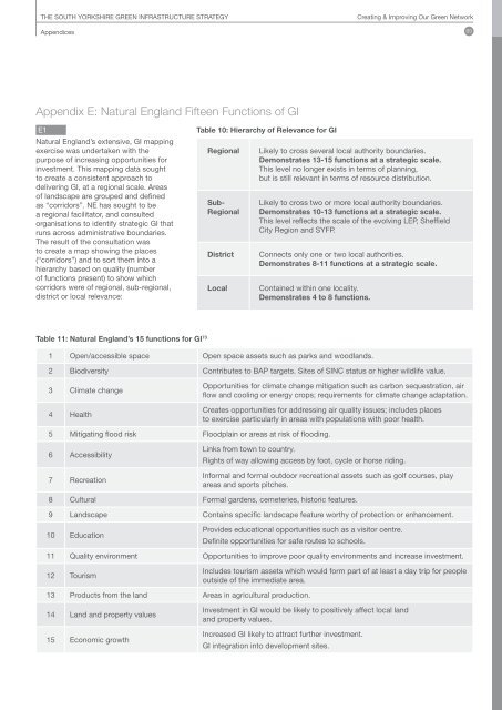
THE SOUTH YORKSHIRE GREEN INFRASTRUCTURE STRATEGYCreating & Improving Our Green Network<strong>Appendices</strong> 85Appendix E: Natural England Fifteen Functions of GIE1Natural England’s extensive, GI mappingexercise was undertaken with thepurpose of increasing opportunities forinvestment. This mapping data soughtto create a consistent approach todelivering GI, at a regional scale. Areasof landscape are grouped and definedas “corridors”. NE has sought to bea regional facilitator, and consultedorganisations to identify strategic GI thatruns across administrative boundaries.The result of the consultation wasto create a map showing the places(“corridors”) and to sort them into ahierarchy based on quality (numberof functions present) to show whichcorridors were of regional, sub-regional,district or local relevance:Table 10: Hierarchy of Relevance for GIRegionalSub-RegionalDistrictLocalLikely to cross several local authority boundaries.Demonstrates 13-15 functions at a strategic scale.This level no longer exists in terms of planning,but is still relevant in terms of resource distribution.Likely to cross two or more local authority boundaries.Demonstrates 10-13 functions at a strategic scale.This level reflects the scale of the evolving LEP, SheffieldCity Region and SYFP.Connects only one or two local authorities.Demonstrates 8-11 functions at a strategic scale.Contained within one locality.Demonstrates 4 to 8 functions.Table 11: Natural England’s 15 functions for GI 731 Open/accessible space Open space assets such as parks and woodlands.2 Biodiversity Contributes to BAP targets. Sites of SINC status or higher wildlife value.3 Climate change4 HealthOpportunities for climate change mitigation such as carbon sequestration, airflow and cooling or energy crops; requirements for climate change adaptation.Creates opportunities for addressing air quality issues; includes placesto exercise particularly in areas with populations with poor health.5 Mitigating flood risk Floodplain or areas at risk of flooding.6 Accessibility7 RecreationLinks from town to country.Rights of way allowing access by foot, cycle or horse riding.Informal and formal outdoor recreational assets such as golf courses, playareas and sports pitches.8 Cultural Formal gardens, cemeteries, historic features.9 Landscape Contains specific landscape feature worthy of protection or enhancement.10 EducationProvides educational opportunities such as a visitor centre.Definite opportunities for safe routes to schools.11 Quality environment Opportunities to improve poor quality environments and increase investment.<strong>12</strong> TourismIncludes tourism assets which would form part of at least a day trip for peopleoutside of the immediate area.13 Products from the land Areas in agricultural production.14 Land and property values15 Economic growthInvestment in GI would be likely to positively affect local landand property values.Increased GI likely to attract further investment.GI integration into development sites.