Adaptation to Water-Induced Hazards in Chitral, PakistanShishikoh are estimated at 18.75%. While male literacy levels are estimated at 32%, female literacy rates are as low as5.5% (CIDO 2006). Literacy levels among the Ismailis, however, are recorded to be 100% for both male and female. Theannual income of an average household is estimated to be PKR 50,119 ($603.84). The average income is made up ofboth on-farm and off-farm sources. Like any subsistence economy, food items account for over 76.87% of the householdbudget, followed by clothing which accounts for 10.70% of the budget. Health care appears third among householdpriorities using 7.79% only. Education is fourth, accounting for 2.83% of the budget (IUCN 2005b).Shishikoh valley is a classic example of too much water in the shape of devastating fl ash fl oods. The fertile, irrigated land isin danger of being washed away by these fl oods. Rectifi cation of the situation is beyond the resources and means of localcommunities. The inhabited and cultivated land in the valley has been shrinking for many decades due to these fl oods andmany people have migrated or settle up in the hills because of land erosion. There are clear signs of land erosion and miseryresulting from rapid and sustained deforestation as a consequence of fl oods (IUCN 2005b). Every year whenever a small fl oodoccurs, elders in the village recount stories related to bigger fl oods that have happened in the past. Elders claim that the fl oodin 2006 was “greater than previous ones” ( personal communication from Islamuddin, Aziz Urahman, Gul Muhammad Jan,Rashidullah, Khan Zarin, Ghulam Jafar, Gurin village, Shishikoh Valley, Lower Chitral, in Dekens 2007). The mountains oncegreen with pines are denuded and the circumstances are ripe for fl oods. Flash fl oods are a common phenomenon in denudedmountains where there are streams which have played havoc by ruining homes, schools, health infrastructure, and mosques.MulkhowMulkhow: is one of the oldest, inhabited valleys in Chitral. It is located to the north about 85 km away from the districtcentre at 36.193173 degrees latitude and 72.143999 degrees longitude.The valley is surrounded on all sides bymountains and the Torkhow River fl ows through it in a north-south direction. Towards the east lies the small plateau ofQaqlasht (which translates as dry land) whereas the permanently snow-clad Terichmir peak nearby reaches a height of7,696 m. The average height of the mountains (Hindu Kush range) in this region is 4,572 m. The valley is in a sub-tehsil ofthe Chitral District and is further divided into four Union Councils: Oveer, Kosht, Mulkhow, and Terich. Due to its undulatingterrain it is divided into lower and upper parts in which the upper parts constitute a single cropping zone and the lowerparts lie under double cropping zones. The soil of the low land (below 2,135m) is sandy gravel while that in the upperarea above 2,135m is comprised of mostly clay soil. The total population of Mulkhow is 13, 998 with more than 1,600households (Government of Pakistan 1998). The area is inhabited by a single, ancient ethnic group called the Khow. TheKhow consider themselves to be the original ancient inhabitants of Chitral. There are two main branches of Islam, i.e., Sunniand Ismailis. The Sunnis are in the majority whereas the Ismailis constitute about fi ve per cent (KLSO 2008).Agriculture is the main occupation, but people do keep livestock for household consumption and to supplement their cashincomes. The area doesn’t have any forests and all the fi rewood is transported form Chitral town. People grow poplar andRobinia on the slopes and around their fi elds to supplement their fi rewood supplies. Agriculture is wholly dependent onsurface irrigation, i.e., a network of small irrigation channels. The perennial streams from glacial melt and natural springsare the only source of irrigation and drinking water. The springs and perennial streams start to dry up in spring from aboutthe middle of March and with the commencement of summer, in June, the area faces acute water shortages and waterfrom the head or source hardly reaches the lower villages at the tail end. As a result, not all cultivable land is croppedduring the summer season, which is the best season for agricultural production. Whatever crops and fruit trees exist sufferfrom water scarcity. The area has nutrient rich and fertile land and is suitable for production of cash crops (i.e., rice andpotatoes) but due to shortage of water the farmers are not able to exploit this opportunity. Wheat is the main winter crop.Maize is cultivated for livestock and pulses are also grown on small patches of land during summer. It is worth mentioningthat being in a low productive zone for wheat means that the majority of households purchase wheat from grain supplystores which are subsidised by the government.The communication system in Mulkhow is very poor. The road passing through the whole region does not have a tarmacsurface and is in very poor condition. Recently, a wireless telephone facility was installed in the area, but it is out of order mostof the time. There is only one Basic Health Unit (BHU) with one male doctor to cater to the needs of the whole population.There is a police station, bank, and high school, but students have to go to Boone or Chitral to go to college. Lack of collegesis pointed out to be the main reason for an increase in dropouts after tenth grade, especially among girls. Construction of twoprivate sector colleges began in early 2009, however.10
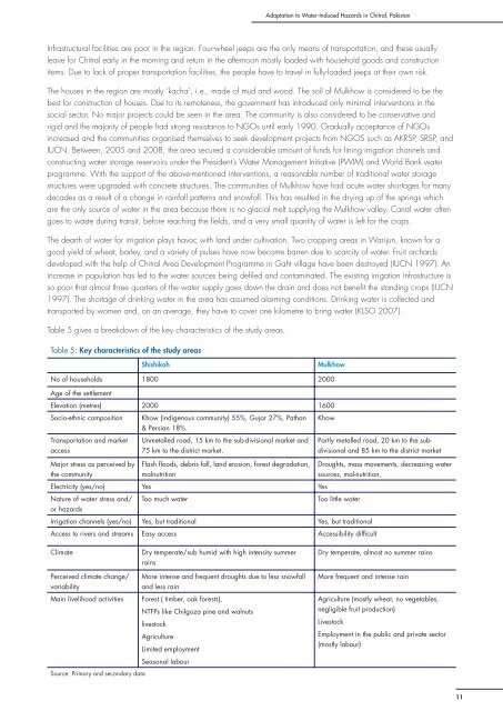
Adaptation to Water-Induced Hazards in Chitral, PakistanInfrastructural facilities are poor in the region. Four-wheel jeeps are the only means of transportation, and these usuallyleave for Chitral early in the morning and return in the afternoon mostly loaded with household goods and constructionitems. Due to lack of proper transportation facilities, the people have to travel in fully-loaded jeeps at their own risk.The houses in the region are mostly ‘kacha’, i.e., made of mud and wood. The soil of Mulkhow is considered to be thebest for construction of houses. Due to its remoteness, the government has introduced only minimal interventions in thesocial sector. No major projects could be seen in the area. The community is also considered to be conservative andrigid and the majority of people had strong resistance to NGOs until early 1990. Gradually acceptance of NGOsincreased and the communities organised themselves to seek development projects from NGOS such as AKRSP, SRSP, andIUCN. Between, 2005 and 2008, the area secured a considerable amount of funds for lining irrigation channels andconstructing water storage reservoirs under the President’s Water Management Initiative (PWIM) and World Bank waterprogramme. With the support of the above-mentioned interventions, a reasonable number of traditional water storagestructures were upgraded with concrete structures. The communities of Mulkhow have had acute water shortages for manydecades as a result of a change in rainfall patterns and snowfall. This has resulted in the drying up of the springs whichare the only source of water in the area because there is no glacial melt supplying the Mulkhow valley. Canal water oftengoes to waste during transit, before reaching the fi elds, and a very small quantity of water is left for the crops.The dearth of water for irrigation plays havoc with land under cultivation. Two cropping areas in Warijun, known for agood yield of wheat, barley, and a variety of pulses have now become barren due to scarcity of water. Fruit orchardsdeveloped with the help of Chitral Area Development Programme in Gaht village have been destroyed (IUCN 1997). Anincrease in population has led to the water sources being defi led and contaminated. The existing irrigation infrastructure isso poor that almost three quarters of the water supply goes down the drain and does not benefi t the standing crops (IUCN1997). The shortage of drinking water in the area has assumed alarming conditions. Drinking water is collected andtransported by women and, on an average, they have to cover one kilometre to bring water (KLSO 2007).Table 5 gives a breakdown of the key characteristics of the study areas.Table 5: Key characteristics of the study areasShishikohMulkhowNo of households 1800 2000Age of the settlementElevation (metres) 2000 1600Socio-ethnic compositionTransportation and marketaccessKhow (indigenous community) 55%, Gujar 27%, Pathan& Persian 18%.Unmetalled road, 15 km to the sub-divisional market and75 km to the district market.KhowPartly metalled road, 20 km to the subdivisionaland 85 km to the district marketMajor stress as perceived bythe communityFlash floods, debris fall, land erosion, forest degradation,malnutritionDroughts, mass movements, decreasing watersources, mal-nutrition,Electricity (yes/no) Yes YesNature of water stress and/ Too much waterToo little wateror hazardsIrrigation channels (yes/no) Yes, but traditional Yes, but traditionalAccess to rivers and streams Easy access Accessibility difficultClimatePerceived climate change/variabilityMain livelihood activitiesDry temperate/sub humid with high intensity summerrainsMore intense and frequent droughts due to less snowfalland less rainForest ( timber, oak forests),NTFPs like Chilgoza pine and walnutslivestockAgricultureLimited employmentSeasonal labourDry temperate, almost no summer rainsMore frequent and intense rainAgriculture (mostly wheat, no vegetables,negligible fruit production)LivestockEmployment in the public and private sector(mostly labour)Source: Primary and secondary data11