HCVF vNov09_Final.pdf
HCVF vNov09_Final.pdf
HCVF vNov09_Final.pdf

You also want an ePaper? Increase the reach of your titles
YUMPU automatically turns print PDFs into web optimized ePapers that Google loves.
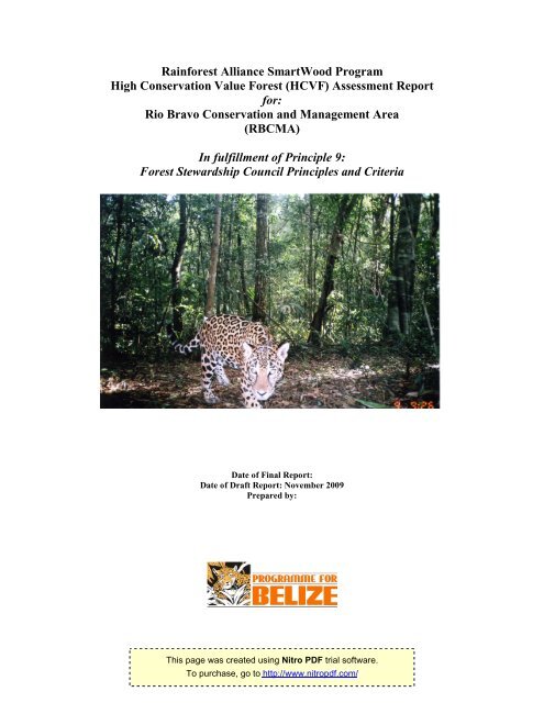
Rainforest Alliance SmartWood ProgramHigh Conservation Value Forest (<strong>HCVF</strong>) Assessment Reportfor:Rio Bravo Conservation and Management Area(RBCMA)In fulfillment of Principle 9:Forest Stewardship Council Principles and CriteriaDate of <strong>Final</strong> Report:Date of Draft Report: November 2009Prepared by:This page was created using Nitro PDF trial software.To purchase, go to http://www.nitro<strong>pdf</strong>.com/
<strong>HCVF</strong> in Rio Bravo Conservation and Management AreaTable of Content1. INTRODUCTION……………………………..……………………...………...……………….. 32. GENERAL OBJECTIVES…………………………………………………..……………….…. 93. HIGH CONSERVATION VALUE 1……………………………...….…..…..……..............,... 103.1 HCV 1.1 Protected Areas…… …………….…..………….…..….…........... 103.2 HCV 1.2 Threatened or Endangered Species……………...………......... 163.3 HCV 1.3 Endemic Species……………………..…………..…………......... 203.4 HCV 1.4 Critical Temporal Concentrations……….……..………………... 214. HIGH CONSERVATION VALUE 2………………………..…………................................. 245. HIGH CONSERVATION VALUE 3…………………………...…………..………………….. 286. HIGH CONSERVATION VALUE 4…………………………….…………..………………..,. 306.1 HCV 4.1 Forest areas that provide basic services of nature in criticalsituations……………………..……………………..…………….… 306.2 HCV 4.2 Forest areas critical to erosion control……………...…………… 346.3 HCV 4.3 Forest providing barriers to destructive fires………..………..… 38.7. HIGH CONSERVATION VALUE 5 & 6 ……………………………….…………………….. 418. HIGH CONSERVATION VALUE areas indentified in the FMU…..…………………….. 449. Analysis of Conservation Priorities…..…………………………………………………… 4510. <strong>HCVF</strong> Management and Monitoring……………………………………………………….. 4711. References……………..………………………………………………………………………. 4812. Acknowledgements…………………………………………………………………………… 4913. Annexes………………………………………………………………………………………… 5013.1 Annex 1: FSC Principle #9: Maintenance of High Conservation ValueForests………….…………………………………………………………….............. 5013.2 Annex 2: FSC Definition of <strong>HCVF</strong>…………...…….………..……………………… 5113.3 Annex 3: Community Consultation Proceeding …………………………………. 5213.3 Annex 4: Recommendation for Management and Monitoring…………………… 59This page was created using Nitro PDF trial software.To purchase, go to http://www.nitro<strong>pdf</strong>.com/2
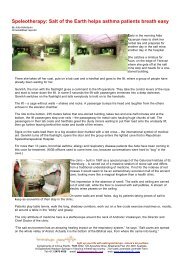
<strong>HCVF</strong> in Rio Bravo Conservation and Management Area1.0 IntroductionThis report presents the findings of an assessment of High Conservation Value Forests (<strong>HCVF</strong>s) in theRio Bravo Conservation and Management Area (Rio Bravo or RBCMA) in northwestern Belize. InNovember 2008, Programme for Belize (PfB) staff began the assessment process with a literature reviewand drafted a report in January 2009. In the first quarter of 2009, relevant maps were also created andused to produce an overall <strong>HCVF</strong>. Expert comments and community inputs will be an integral part of thefinal report. The report covers the entire Ro Bravo, the forest management unit managed by PfB.Programme for Belize, under its SmartWood Certification Agreement 2009-2013 (SW-FM/CoC-000031),is charged with fulfilling the Forest Stewardship Councils Principles and Criteria for Forest Management(FSC-PC-FM). The principle and criteria under the scope of this document is Principle 9: Maintenance ofHigh Conservation Value Forests. Principle 9 states that “Management activities in high conservationvalue forests shall maintain or enhance the attributes which define such forests. Decisions regarding highconservation value forests shall always be considered in the context of a precautionary approach” andthat “Assessment to determine the presence of attributes consistent with high conservation value forestswill be completed appropriate to the scale and intensity of forest management.(RainforestAlliance/SmartWood Interim standards for Assessing Forest Management in Belize, 2008).”Map 1: Location of Rio Bravo/RBCMAThis page was created using Nitro PDF trial software.To purchase, go to http://www.nitro<strong>pdf</strong>.com/3
<strong>HCVF</strong> in Rio Bravo Conservation and Management Area1.1 The Forest Management UnitThe Rio Bravo Conservation and Management Area (RBCMA or Rio Bravo) is a private protected arealocated in north western Belize and centered on coordinates 17 o 45’N 88 o 50’W (Map 1), secured through aseries of land purchases between 1989 and 1998. Programme for Belize, established in 1988, owns andmanages the land and operates under the terms of a formal Memorandum of Understanding (MoU) withthe Government of Belize. Programme for Belize is a non-governmental organization with a public trust,dedicated to holding the land in perpetuity to conserve natural heritage and biodiversity if Belize andcontribute to the sustainable management of the area and the economic development of northern Belize.In return, the government waives land taxes. The terms of the MoU define a management regimedesigned to ensure long-term protection and maintenance of biological diversity while at the same timeproviding a sustainable flow of natural products and services, corresponding to an IUCN category VIProtected Area: a managed resource area. The management approach is, however, very conservativewith over half the area under full protection (RBCMA Management Plan 2006-2010).Covering 251,585 acres or 101,813.25 ha (based on land title documents and 1 ha = 2.47 acres), the RioBravo is the largest private reserve in Belize and its forest is contiguous with that of Calakmul and theMaya Biosphere Reserves creating a forest bloc of at least 4 million acres (1.6 million ha), the largestremaining forest area in Central America. In Belize, it is adjacent to the Aguas Turbias National Park andto the Spanish Creek Wildlife Sanctuary. As such, the RBCMA has been assessed as an important areato maintain biological connectivity, diverse landscapes and as a repository for endangered or threatenedspecies (Rio Bravo Management Plan 2006–2010, Annex 9).Sixteen major habitats (corresponding to 22 vegetation types) are recognized in the area.Map 2: RBCMA VegetationThis page was created using Nitro PDF trial software.To purchase, go to http://www.nitro<strong>pdf</strong>.com/4
<strong>HCVF</strong> in Rio Bravo Conservation and Management AreaThe RBCMA contributes over 90% of the national protected area coverage of four types and makessignificant contribution to the conservation of at least four others. Its forest has been providing importantsocio-economic benefits since the 18 th century through the production of timber, chicle and wild game.Today, the Rio Bravo is a portion of a wider landscape of varying uses, including conservation, forestry,agriculture and urban development. The Rio Bravo therefore represents an important center forbiodiversity, ecosystem services, and timber production.1.2 The Rio Bravo Management ZonesThe provisional management zones have been in place with relatively minor modification since 1992 and,as envisioned originally, can be revised. It nonetheless retains its underlying rationale and essentialstructure based on Man and Biosphere Reserve principles.SmartWood verified Land Use Classes (2008 Audit)Management Zones: land use Area (ha) % total areaTimber Zone 40,761 39.9Protection Zone 43,502 41.4Pine Savannah Zone (Protection Zone) 16,873 16.1Infrastructure/Tourism Zone 3,752 3.6i. The Protection Zone creates a large protected zone extending throughout the RBCMA andconnected along the main streams. It covers a large area of high (upland) forest and all thewetlands, swamp forests and thickets on the area. Permitted activities include: protectivepatrolling, biological and archaeological survey and monitoring, non-manipulative research,primarily observational but permitting collection for identification purposes using selectivetechniques, and low impact tourism and educational visits.Generous protection buffers of between 25-250 meters provide ample protection to sensitiveecosystems in area of high human activity.ii.The Timber Zone combines the original ‘secondary forest products’ and ‘experimental timberextraction’ zones. It represents the production forest area within the RBCMA, covering all thetaller broad-leaved forest formations on level to moderately sloping ground with firmcalcareous soils.The zone has the effect of creating a broad buffer around the protected core. Its extension isjustified on the basis of increased confidence that well-managed timber operations arecompatible with biodiversity conservation values and can be effectively managed by PfB. Italso pushes an active management presence into recognized ‘hot-spots’ of illicit activity.Spot-zones are used to conserve specific features at a finer scale.iii.The Pine Savannah Zone (Protection Zone) is defined as those areas where fire is a keypart of the system, both for management and as an ecological process. They correspond tothe Puletan soil areas covered by the short-grass savannah vegetation types carryingshrubby and pine/oak formations. They also include the transitional woodlands on thesavannah fringe (Protection Zone). Savannah management is aimed at:Conserving their outstanding qualities for biodiversity conservation.Rehabilitating pine stands as a potential resource that can act as the basis for:a. A management regime with wider application across northern Belize (i.e.analogous to the development of the broadleaf forest regime);b. Revenue generation for conservation management by PfB;c. Kyoto-compliant carbon sequestration through restoration of tree cover.This page was created using Nitro PDF trial software.To purchase, go to http://www.nitro<strong>pdf</strong>.com/5
<strong>HCVF</strong> in Rio Bravo Conservation and Management AreaCapacity to control and manage fire is critical to savannah management and assists management ofbroadleaf forest and herbaceous swamp.iv.& v The Infrastructure zone/Tourism Zones together are a relatively small area comprisingroads and stone quarries, visitor and staff facilities, guard houses and recreational area modified tosuit visitor’s need. These zones allow the Rio Bravo to be used as a living laboratory, recreationalarea, and allow access to sustainable use resources.Why Assess the Rio Bravo for HCVs?Map 3: RBCMA ZonationThe PfB has been developing a sustainable timber harvesting programme since 1994 as an experimentalphase and transitioned into full operational form since 2004 under a long-term license (Long-term PrivateForest License 01/07-LTPFL 01/07) provided by the Government of Belize. This process is detailed inthe Hardwood Timber Business Plan (Wilson, 2004) and the RBCMA Forest Management Plan 2006). Itsobjective is to demonstrate good forest management meeting highest international standards (as set bythe Forest Stewardship Council), to contribute to the local economy, and to create a supplementary selfgeneratedrevenue stream for the protection and management of the Rio Bravo.The goal of forest management on the RBCMA is:“To demonstrate sustainable use of forest resources, generating revenues for re-investment inconservation management through activities that neither compromise the biodiversity of the area nor thefuture value of the resource”.This page was created using Nitro PDF trial software.To purchase, go to http://www.nitro<strong>pdf</strong>.com/6
<strong>HCVF</strong> in Rio Bravo Conservation and Management AreaApart from becoming a revenue-generating activity, the hardwood timber management programmemakes a strong demonstration of good forest management highly pertinent to improving current practicethroughout the country. As the most reliable source of high quality timber in the area, it also substantiallystrengthens the contribution made by the RBCMA to the local economy. It forms part of the carbonsequestration pilot project by providing income to maintain protection/monitoring and by promoting highmahogany stocking. Furthermore, aspects of the planned silvicultural programme lend themselves todirect community participation.By applying the <strong>HCVF</strong> methodology to the management practices of PfB in the Rio Bravo, existinginformation will be consolidated and the elements that should be considered by those responsible fordecision making and those planning sustainable management activities will be highlighted. It is our hopethat this exercise will facilitate the development of future conservation efforts, particularly those forestmanagers in Belize applying for FSC forest management certification.High Conservation Value Forest AssessmentAll forest are important, having environmental, economic, and social values, such as providing habitat forwildlife, watershed protection, supply of natural resources to sustain the daily life communities andpreserving areas of cultural significance. When these values are assessed as highly significant or ofcritical importance to maintain biodiversity, environmental services and economic livelihood, then theseforests can be defined as High Conservation Value Forests (<strong>HCVF</strong>) (ProForest 2003).The concept of <strong>HCVF</strong> was established in the Forest Stewardship Council (FSC) Principles and Criteria forForest Stewardship in 1999 (www.fscus.org) and is identified as Principle 9: Maintenance of HighConservation Value Forests (Annex 1). These FSC Principles and Criteria are incorporated into theevaluation process of all certification organizations seeking accreditation by the FSC. The <strong>HCVF</strong> concepthas provided a revolutionary approach for managing forests areas that may be used for a specific or awide range of services. The concept is flexible and shifts the focus from managing a forest managementunit (FMU) based on biodiversity or the sustainable production of natural resources to managing forestsfor their exceptional values as identified through a thorough assessment of six High Conservation Values(HVCs) (Rayden 2008).The six HCVs are shown in the table below. These HCVs are extracted directly from the FSC definition of<strong>HCVF</strong> (Annex 2) which is expanded for into the six values in the Proforest <strong>HCVF</strong> Toolkit 2003, eachfurther detailed for more specific assessment leading to more appropriate management plans (ProForest2003).Box 1 The Six High Conservation Values (HCVs)HCV1 Forest areas containing globally, regionally or nationally significant concentration of biodiversityvalues (e.g. endemism, endangered species, refugia)HCV 1.1: Protected AreasHCV 1.2: Threatened or Endangered SpeciesHCV 1.3: Endemic speciesHCV 1.4: Critical temporal useHCV2 Forest areas containing globally, regionally or nationally significant large landscape levelforests, contained within, or containing the management unit, where viable populations of mostif not all naturally occurring species exist in natural patterns of distribution and abundanceHCV3HCV4Forest areas that are in or contain rare, threatened or endangered ecosystemsForest areas that provide basic services of nature in critical situations (e.g. watershedprotection, erosion control)HCV 4.1 Forests critical to water catchmentHCV 4.2 Forest critical to erosion controlHCV 4.3 Forest providing barriers to destructive firesThis page was created using Nitro PDF trial software.To purchase, go to http://www.nitro<strong>pdf</strong>.com/7
<strong>HCVF</strong> in Rio Bravo Conservation and Management AreaHCV5HCV6Forest areas fundamental to meeting basic needs of local communities (e.g. subsistence,health)Forest areas critical to local communities’ traditional cultural identity (e.g. areas of cultural,ecological, economic or religious significance identified in cooperation with such localcommunities)Many forest managers understand the values inherent in forest ecosystems and a lot of information onthe FMU is available and so the values are intrinsically known. However, the benefit of dovetailing thesevalues with the FSC Principles and Criteria is that it integrates the results of many other importantinitiatives and research. As such, results from global, regional, national, and local initiatives will providethe basic information necessary to define a HCV within a particular FMU. Consequently, a large part ofthe effort to implement the <strong>HCVF</strong> concept involves the identification, interpretation and appropriate use ofalready existing data.FSC Principle 9 asks the forest manager to take a wide view and to consider conservation issues of highpriority, or of significance on a national, regional or global scale. It is intended to ensure that values ofnational/international conservation significance are properly identified and addressed and that relevantstakeholders are consulted in the process, and can have input in the management and monitoringdecision relating to these values. Of course, the extent to which stakeholders have direct input dependson the HCVs identified.Under the framework of this exercise, Programme for Belize (PfB) is carrying out the first interpretation ofthe HCV definitions in the Rio Bravo Conservation and Management Area (Rio Bravo or RBCMA) and thefirst in Belize. This methodology has been implemented and defined in other countries at national andsub-national levels (www.hcvnetwork.org), this is the first experience where the challenge has been toapply the <strong>HCVF</strong> methodology in regionally and national important private reserve in the northwestern partof Belize, the Rio Bravo Conservation and Management Area.This page was created using Nitro PDF trial software.To purchase, go to http://www.nitro<strong>pdf</strong>.com/8
<strong>HCVF</strong> in Rio Bravo Conservation and Management Area2.0 General ObjectiveIdentify the elements of High Conservation Value (HCV) in the FMU: Rio Bravo Conservation andManagement Area (RBCMA).Specific Objectives1. To identify the HCVs within the defined FMU: RBCMA2. To propose a boundary delineation for <strong>HCVF</strong> within this FMU.3. Propose management and monitoring guidelines and recommendations that ensure themaintenance, or even the enhancement <strong>HCVF</strong>s identified.ApproachThis paper represents the first interpretation of the HCV definition in Belize and more specifically theapplication of this methodology in a particular site. The High Conservation Value Forest Toolkit, 2003and the Assessment, management and monitoring of High Conservation Value Forest, 2008 developedby ProForest were used as guiding documents for this project. The <strong>HCVF</strong> toolkit takes the FSC definitionand describes a series of steps to conduct a systematic evaluation of the conservation values (attributes)that exist in a forest, and to establish a rationale for those values that are particularly significant and forwhich conservation is of critical importance. Principle 9 of the FSC Principles and Criteria calls for theapplication of the “precautionary approach” in designing management activities in <strong>HCVF</strong> and thesemanagement activities shall maintain or enhance the attributes that define such forests. Theprecautionary approach calls for conservation actions even if full scientific evidence of an environmentalthreat is not available.In its Forest Management Plan and Operational Guidelines 2006-2010, PfB recognizes that in theabsence of complete data, the Precautionary Principle (PP) must be applied. This is applied by allowinggenerous buffer zones, setting aside strict protection zones and retaining seed trees in the productionareas.The steps to follow in HCV assessment are:1. First: Identify existing plans, schemes and maps that characterize all or part of the FMU asbeing priority areas for that value.2. Second: Evaluate whether the identified value is significant enough to delineate as <strong>HCVF</strong>3. Third: Verify <strong>HCVF</strong> with relevant stakeholders4. Fourth: Develop specific management actions necessary to maintain the value(s).Once the <strong>HCVF</strong>s of the RBCMA have been identified, delineated and verified, the conservation prioritiesare to be established and distribution maps created for each HCV criteria so that a clear hierarchy of<strong>HCVF</strong> priorities is obtained ranging from those sites that meet the highest level of HCV criteria possible,to those that cover no more than one criterion, bearing in mind that the management of the entire FMUapplies the precautionary approach.This page was created using Nitro PDF trial software.To purchase, go to http://www.nitro<strong>pdf</strong>.com/9
<strong>HCVF</strong> in Rio Bravo Conservation and Management Area3.0 HCV 1 Globally, regionally or nationally significant concentrations of biodiversity values3.1 HCV 1.1 Protected AreasBackground and Information SourcesThe RBCMA was established in 1989 as a private reserve to conserve forested land in north-westernBelize threatened with fragmentation and clearance following the break-up of the Belize Estate andProduce Co. (BEC) holdings in the area. It now covers 251,585 acres secured through a series oftransactions involving the original BEC property which also included Yalbac, Gallon Jug and parts of theNew Hope area.The RBCMA is located in the Orange Walk District of north-western Belize, centered on coordinates 17 045’N 88 0 50’W. At 260,000 acres (Map 2: Protected Areas of Belize), it is the second largest protectedareas in the country, covering 4.4% of its total land area and approximately 21.2% of Orange WalkDistrict. The RBCMA lies in the international frontier linking directly onto the Rio Azul National Park inGuatemala and in Belize to Aguas Turbias National Park in the northwest, which also adjoins theinternational frontier with Quintana Roo, Mexico, and the Spanish Creek Wildlife Sanctuary in thesoutheast. To the south and east it shares property boundaries with Gallon Jug and Yalbac, two largeprivately owned tracts of land that are still mostly forested and are being managed to some degree withconservation in mind.RBCMAMap 4: Protected Areas of BelizeThis page was created using Nitro PDF trial software.To purchase, go to http://www.nitro<strong>pdf</strong>.com/10
<strong>HCVF</strong> in Rio Bravo Conservation and Management AreaThe RBCMA is owned and managed by Programme for Belize (PfB), a local conservation nongovernmentalorganization (NGO), under the terms of a formal Memorandum of Understanding with theGovernment of Belize. The management regime is based on ecosystem protection and sustainable useof forest resources, therefore corresponding to an IUCN category VI protected area: Managed ResourceProtected Area.IUCN CATEGORY VI PROTECTED AREAManaged Resource Protected Area: protected area managed mainly for thesustainable use of natural ecosystemsDefinition: Area containing predominantly unmodified natural systems, managed toensure long term protection and maintenance of biological diversity, while providingat the same time a sustainable flow of natural products and services to meetcommunity needs.The area is also an important component of the Belize National Protected Area System and a naturalcross-border extension of the Maya Biosphere Reserve in Guatemala.CalakmulBiosphereReserveMayaBiosphereReserveRio BravoReserveMap 5: Major Regional Protected AreasThis page was created using Nitro PDF trial software.To purchase, go to http://www.nitro<strong>pdf</strong>.com/11
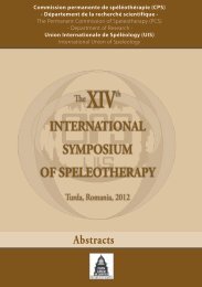
<strong>HCVF</strong> in Rio Bravo Conservation and Management AreaBelizean ecosystems (here equating to the principal vegetation types) have been described and mappedin a series of exercises over the past 50 years. The most recent works (Meerman & Sabido 2001,Meerman 2004 - Map 3) classify and map the vegetation under a scheme applied across CentralAmerica. It also incorporates previous work, including Brokaw 1998 (in Mallory et al, 1998), the mostrecent and most detailed habitat characterization and mapping specific to the RBCMA. In turn, Brokawincorporates a vegetation map specific to the Rancho Dolores Savannah developed by Bridgewater et al,1997. Eighteen Ecosystems or habitats/vegetation types are recognized in the area. The RBCMAcontributes over 90% of the national protected area coverage of four vegetation types (Table 1), protectsmost of the inland mangroves under protected area status and makes significant contribution to inconserving of at least four others vegetation types.Table 1: RBCMA vegetation types contributing over 90% to national protected area coverageVegetationCode1A2a(1)(b)K - CW1A2a(1)(b)K-TP1A2f(2)(a)IIIA1b(a)LEDescriptionTropical evergreen seasonal broadleaf forest over calcareous soils - central western variantTropical evergreen seasonal broadleaf forest over calcareous soils - Tehuantepec-PetenvariantTropical evergreen seasonal broadleaf alluvial forestEvergreen low land broadleaf shrub land dominated by leguminous shrubsFor a complete description of the ecosystems consult RBCMA 2006-2010 Management Plan. Theircontribution to the National Protected Area System (NPAS) is very high, contributing significantly toconnectivity, habitats, endangered species, endemic species and environmental services (Tables 3-4,RBCMA 2006-2010 Management Plan).This page was created using Nitro PDF trial software.To purchase, go to http://www.nitro<strong>pdf</strong>.com/12
<strong>HCVF</strong> in Rio Bravo Conservation and Management AreaMap 6: Vegetation of the RBCMA (Meerman 09)FaunaThe fauna (RBCMA 2006-2010 Management Plan, Annexes 5-8) has also been well-studied withresearch and survey projects covering all the major groups. In general terms diversity is high (e.g. over 79mammals, over 350 bird species), including foraging and breeding habitat for a range of species ofconservation concern (RBCMA 2006-2010 Management Plan, Annex 10). As with the flora the mostimportant characteristic is that wildlife occurs in fully functioning communities characteristic of the area,most clearly demonstrated by the diversity and relative commonness of top predators e.g. large cats(Wultsch 2008) and birds of prey (pers. observation). The area has therefore been selected for reintroductionof the globally threatened Harpy Eagle (Harpia harpyja), a species highly dependent onextensive areas of forested lands having medium sized prey species such as spider monkey and greyfox.This page was created using Nitro PDF trial software.To purchase, go to http://www.nitro<strong>pdf</strong>.com/13
<strong>HCVF</strong> in Rio Bravo Conservation and Management AreaDefinition of HCV 1.1Considering that the entire area of the RBCMA is a private protected area, has been recognized asnationally significant and adjoins the Aguas Turbias National Park and Spanish Creek Wildlife Sanctuaryin Belize and the Maya and Calakmul Biosphere Reserves in Guatemala and Mexico, the entire 251,585acres is a HCV 1.1 area.Parameters and Threshold ConsideredFor the interpretation of the priority importance areas within HCV 1.1, the parameter adopted was theperpetual conservation perspective provided by each of the properties in Belize around the RBCMAillustrated in the Map for HCV1.1 (Map 7: RBCMA & Adjacent Protected Lands). The lands in Guatemalaand Mexico are excluded from this exercise since we do not know the extent of their security.Map 7: RBCMA & Adjacent Protected LandsThis page was created using Nitro PDF trial software.To purchase, go to http://www.nitro<strong>pdf</strong>.com/14
<strong>HCVF</strong> in Rio Bravo Conservation and Management AreaInterpretation of HCV 1.1Categories for HCV 1.1 Interpretation Score Surface Area (ha)Rio Bravo Conservation and Management Area as a High HCV 3 106,900 haprivate reserve is not at the mercy of any government thatconsiders de-reservation of protected areasAguas Turbias National Park. There is an absence of Medium HCV 2 3,541 haactive management of this park thereby allowing allpossible illegal activities (poaching, timber theft, marijuanafields, etc.)Spanish Creek Wildlife Sanctuary. This sanctuary is Medium HCV 2 2,429 hamanaged by a community group with limited funding.Yalbac and Gallon Jug Properties. Even though theseproperties have a large percentage of forest cover, theycan be deforested at any time based on the land owners’priorities.Low HCV 1 54,154 +67,323 ha= 121,477 haRecommendation for <strong>HCVF</strong> Management1. Maintain management presence/patrols in the entire RBCMA and clearly demarcateboundary, especially in hotspots.2. Liaise with government to institute proper management of the Aguas Turbias National Park.This will ensure landscape connectivity in northwest Belize and buffer the core protectionzone of the RBCMA.3. Liaise with managers of the Spanish Creek Wildlife Sanctuary. This will ensure landscapeconnectivity in south east Belize and buffer the core protection zone of the RBCMA.4. Continue working with the Tri-National Coordinating Group of the Selva Maya Project 1 .Recommendation for <strong>HCVF</strong> Monitoring1. Maintain records of boundary patrols.2. Be highly disciplined in carrying out management/forestry practices and verify forest conditionthrough annual audits of impacted areas.1 The Tri-national Coordinating Group of the Selva Maya Project is under the administration of CATIE. The governments of Belize, Mexico andGuatemala have committed to working together in projects that will ensure the conservation of natural areas and environmental services in adjacentlands.This page was created using Nitro PDF trial software.To purchase, go to http://www.nitro<strong>pdf</strong>.com/15
<strong>HCVF</strong> in Rio Bravo Conservation and Management Area3.2 HCV 1.2 Threatened or Endangered SpeciesBackground and Information Sources (Most information based on PfB Management Plan 2006-2010)..The RBCMA is the largest private protected area and the second largest overall in Belize. This areacontributes significantly to the biodiversity of the country and the region and is a refugium to manythreatened or endangered species. The area to the north and east of the reserve is destined forclearance with the expansion of the agricultural frontier which is significantly reducing the availablehabitat for forest species such as tapir (Tapirus bairdii), jaguar (Panthera onca), spider monkey (Atelesgeoffroyi), howler monkey (Allouata pigra), forest falcons and other birds of prey. In a 2008 study, C.Wultsch analyzed DNA from cat scat samples collected in the northwest RBCMA and detected jaguars 34times, pumas 32 times, ocelot 30 times and one margay. The result showed 37 individual cats: 9 jaguars,18 pumas, 9 ocelots and 1 margay. The author concluded that these results show the RBCMA as anarea of high priority for cat conservationThe flora and fauna of the RBCMA has been extensively studied (RBCMA Management Plan 2006-2010,Annex 4-8) and show characteristics of communities of both the Peten and Yucatan regions. To date,240 woody plant species, over 79 mammal and 350 bird species have been recorded in the RBCMA. Ofparticular importance is the savanna ecosystem that contains a rare vegetation type with a few speciesknown only from Belize. Other groups, e.g. reptiles, fishes, amphibians, and invertebrates have alsobeen studied. Several species are listed as being of conservation concern at a national or internationallevel (RBCMA Management Plan 2006-2010, Annex 9) using the IUCN Red List and CITES classification.Species that are common within the reserve, e.g. crested guan (Penelope purpurascens) and greatcurrasow (Crax rubra) are rare or absent in the adjacent large agricultural fields. Because of its richbiodiversity and size, the RBCMA is the highest –scoring site within the National Protected Areas System(NPAS) of Belize (Meerman, Jan, J.R.Wilson. Editors. Nov. 2005. Belize National Protected AreasSystem Plan, Appendix 2.8). Of course, less charismatic taxonomic groups such as moths, fungi, andnon-woody plant species need further research. Future work will certainly lead to the identification ofother species of conservation concern.A 2007 national Key Biodiversity Areas study (Meerman, 2007) identified areas in Belize with high densityof IUCN-red listed species. One of the identified areas is the “Selva Maya” which includes the Rio BravoConservation and Management Area + Gallon Jug and Aguas Turbias National Park (Map 5).With this in mind, the evaluation and definition of the HCV 1.2 was based on the following:1. Key taxonomic groups with sufficient or acceptable levels of information: birds, reptiles,mammals, plants.2. Species classified as threatened using the IUCN Red List and CITES classification.3. Key Biodiversity areas based on high IUCN red list species occurrence.This page was created using Nitro PDF trial software.To purchase, go to http://www.nitro<strong>pdf</strong>.com/16
<strong>HCVF</strong> in Rio Bravo Conservation and Management AreaMap 8. Key Biodiversity Areas in Belize,nr 14 is the “Selva Maya” area whichincludes the RBCMA, Aguas Turbias NPand the Gallon Jug estate.Definition of HCV 1.2All zones within the RBCMA that hold species of birds, mammals, reptile and/or plants within one of thefollowing threat (categories endangered or vulnerable following IUCN Red List and having Trade Controlsunder CITES) shall be considered as having a HCV. The zones considered for this exercise are basedon broad ecosystem classification: broadleaf forest, pine savanna and wetlands and water ways.Parameters and Threshold ConsideredIn order to prioritize the zones of importance in relation to criteria HCV 1.2, zones were analyzed so as toemphasize the value of those hosting species of birds, reptiles, mammals, and/or plants with a greaterdegree of threat at a global level, and giving a lower category to those only having endangered species ata national level. If a zone is scored with 4 or 3, that zone will be said to contain a HCV and can bedesignated as <strong>HCVF</strong>.Interpretation of HCV 1.2Categories for HCV 1.2 Interpretation Score ZonePresence of globally threatened species under the Very High HCV 4 3endangered, vulnerable and with trade restrictionsThis page was created using Nitro PDF trial software.To purchase, go to http://www.nitro<strong>pdf</strong>.com/17
<strong>HCVF</strong> in Rio Bravo Conservation and Management AreaPresence of globally threatened species under the High HCV 3 3endangered and vulnerable classesPresence of globally threatened species under the Medium HCV 2 3vulnerable classPresence of threatened species at any level Low HCV 2 3HCV 1.2FMU ZoneBroadleafForest 89,500haPine Savanna10,000 haWetlands andWaterwaysScore based on presence of species listed under IUCN Red list and CITESEndangered Vulnerable + NearTrade Restriction SpeciesSpecies threatened speciesYucatan blackhowler monkey,Baird’s tapirYellow-headedparrotCentralAmerican riverturtleMahogany, OccellatedTurkey, Harpy Eagle,Crested Eagle, CeruleanWarbler, Great Currasow,Olive-sided Flycatcher,Puma, Jaguar, YucatanSpider-MonkeyJaguarondi, ocelot, margay,boa constrictor, Mahogany,Occellated Turkey, HarpyEagle, Crested Eagle,Cerulean Warbler, GreatCurrasow, Olive-sidedFlycatcher, Puma, Jaguar,Yucatan Spider-MonkeyJaguar, Jaguarondi, Ocelot Jaguar, Jaguarondi, ocelot, 3West Indian Manatee,Black Catbird, PaintedTurtle, LoggerheadTerrapin, Morelet’sCrocodileNeotropical river otter, jabiru,peregrine falcon, West IndianManatee, Black Catbird,Painted Turtle, LoggerheadTerrapin, Morelet’s CrocodileAll three major ecosystems of the RBCMA can support or enhance the presence of the listed endangeredspecies. Because of protection activities since 1989, some of these endangered species are actuallyvery common within the reserve, e.g. Morelet’s crocodile and Yucatan black howler monkey. Thebroadleaf forest was scored very highly (4) and the pine savanna and wetlands and water ways scoredhigh (3). All zones are therefore <strong>HCVF</strong>s (Map 6: Vegetation Types Preferred by Endangered WildlifeSpecies).Recommendation for <strong>HCVF</strong> ManagementScore1. Endangered species are a conservation priority; their management and the management of theirhabitats should be supported by employing the best practices in extraction activities and the latestinformation on the species.2. Further surveys of flora and fauna should be encouraged whenever possible, particularly of lesserknown taxonomic groups: insects, fungi, orchids, aquatic organisms and non-woody species.Recommendation for <strong>HCVF</strong> Monitoring1. Identify and clearly demarcate endangered tree species, particularly mature trees, during stocksurvey so that steps can be taken to avoid undue damage to the tree during harvest.2. Permanent sample plots and sampling of harvested plots should be done, based on availableresources, so that the effects of harvest on the mortality/survival of threatened species can bemeasured.3. Biodiversity studies should be encouraged so as to update the status of endangered species.This can be done at the species level through the engagement of research institutions anduniversities using indicator species e.g. birds, jaguars and/or bats.4. Continue active ranger patrols in the savannahs to protect yellow-headed parrots and their nests43This page was created using Nitro PDF trial software.To purchase, go to http://www.nitro<strong>pdf</strong>.com/18
<strong>HCVF</strong> in Rio Bravo Conservation and Management AreaMap 9: Vegetation Types Critical to Endangered Wildlife SpeciesThis page was created using Nitro PDF trial software.To purchase, go to http://www.nitro<strong>pdf</strong>.com/19
<strong>HCVF</strong> in Rio Bravo Conservation and Management Area3.3 HCV 1.3 Endemic SpeciesBackground and Information SourcesThe RBCMA has not been considered a center of Belizean endemism. However, a number of Yucatanendemic plants and animals have been documented. The RBCMA does not house many Belizeanendemics for three reasons.1. Extensive research on various subjects has been conducted in the RBCMA without theidentification of Belizean endemic species.2. The RBCMA is part of a larger contiguous forest tract which may have allowed species todisperse throughout the landscape.3. The landscape to the RBCMA and its adjacent forests do not have any major physicalbarriers that could have impeded the dispersal of species which eventually leads to allopatricspeciation 2 .Based on the information above, HCV 1.3 was not identified in the RBCMA and so no <strong>HCVF</strong> status wasassigned._____________________2 Allopatric speciation, also known as geographic speciation, is the phenomenon whereby biologicalpopulations are physically isolated by a barrier causing the population to split preventing interbreeding.This page was created using Nitro PDF trial software.To purchase, go to http://www.nitro<strong>pdf</strong>.com/20
<strong>HCVF</strong> in Rio Bravo Conservation and Management Area3.4 HCV 1.4 Critical Temporal ConcentrationBackground and Information SourcesMost information in regard to HCV 1.3 to date is in regard to the bird population, particularly due to theNeotropical migrants 3 that winter in Central and South America. The physical features of the RBCMA,being mostly fairly level terrain (20-220m elevation), does not support guilds (mammals, insects, etc) thatmove altitudinally since the climatic conditions between life zones are not that extreme. The vegetationcover varies from zone to zone but altitude is not the most significant factor in the plant communitiesencountered. Soil type and land surface shape seem to be more significant.Approximately 350 species of birds are known to occur in the RBCMA and of these approximately 25%are migratory birds. This implies that during some time of the year, particularly in winter, the birdpopulation in the RBCMA is at its peak. Given the diversity of habitats within the reserve, narrowed to 22vegetation types for the purpose of the bird surveys, it was determined that not all vegetation types wouldbe equally important for all the migrants (Wings of the Americas Program 4 ).A multi-year bird study in 1997 and 1998 by Mallory and Vallely under the PfB Wings of the AmericasProgram using a Rapid Bird Assessment (RBA) procedure reported that the 22 vegetation types ofRBCMA were used by neotropical migrants. However, as was anticipated, the results showed that thevegetation types, savanna orchard, tall grass marsh, palmetto savanna, marl flat, and short grass marsh,in eastern RBCMA had the highest percentage of winter residents, between 21.1 and 32.1%, and thepalmetto savanna, riparian forest, second growth forest, upland forest-wamil, and marl flats wereimportant resting/feeding areas for transient migrants 5 . The study reported that 22 bird species haveaverage Partners in Flight 6 (PiF) scores > 19 and of these 10 species are migrants of conservationconcern (wood thrush, blue-winged warbler, golden-winged warbler, bay-breasted warbler, prothonotarywarbler, worm-eating warbler, Swainson’s warbler, Louisiana waterthrush, Kentucky warbler, anddickcissel). This study is the basis for extracting the vegetation types with HCVs (Map 7: VegetationTypes Important to Migratory Birds).____________________________3 A neotropical migrant spends the entire winter in a particular area.4 The Wings of the Americas Program of The Nature Conservancy was based on the fact that migratorybird species are shared between protected areas in Central/South America and protected areas in theUSA. The RBCMA was paired with the Edge of Appalachia Preserve (EoA) with the intent of finding outwhich bird species are shared among the two sites and to develop strategies to help conserve these birdsthrough conservation of the habitats they depend on.5 A transient migrant uses an area for a short time (resting/feeding) while on its way to its final destinationwhere it will pass the winter.6 For more on Partners in Flight visit www.partnersinflight.orgThis page was created using Nitro PDF trial software.To purchase, go to http://www.nitro<strong>pdf</strong>.com/21
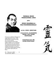
<strong>HCVF</strong> in Rio Bravo Conservation and Management AreaDefinition of HCV 1.4The forest areas with specific habitats that make up biological corridors or key vegetation types formigratory species (nearctic or transient) shall be considered HCV under this criteria.Parameters and Threshold ConsideredThe entire area of the RBCMA provides habitat for one or more migratory bird species. Consequently, wepropose key forest vegetation types where migratory species have been recorded and identified by theWings RBA as most important for bird conservation. The marl flats and grasslands are not forests and soare removed from this consideration.Map 10: Vegetation Types Important to Migratory BirdsThis page was created using Nitro PDF trial software.To purchase, go to http://www.nitro<strong>pdf</strong>.com/22
<strong>HCVF</strong> in Rio Bravo Conservation and Management AreaInterpretation of HCV 1.4Categories of HCV 1.4 Interpretation Score Vegetation TypesPresence of neotropical winterresident/transientbird species with PiF ≥19scoreHigh HCV 3 Lowland BroadleafForestRecommendation for ManagementAll important natural habitats for birds are substantially protected within the management system of PfB.Of the highest ranking vegetation types, riparian forests, upland forest (dry & mesic) and bajo are wellrepresented in the protection zone and buffer zones. However, upland mesic forest which ranks highly iswithin the timber extraction zone, the eastern RBCMA. Strict adherence to Reduced Impact Logging(RIL) guidelines and respect for buffers along waterways and bajos is necessary.Recommendation for <strong>HCVF</strong> MonitoringMonitoring of biodiversity, particularly the logging impacts on the bird population of the RBCMA, isessential to ensure that extraction activities are sustainable. Birds, especially neotropical migrants ofglobal concern, should be of particular interest as their presence can be used as an indicator of foresthealth.This page was created using Nitro PDF trial software.To purchase, go to http://www.nitro<strong>pdf</strong>.com/23
<strong>HCVF</strong> in Rio Bravo Conservation and Management Area4.0 HCV 2 Globally, regionally or nationally significant large landscape level forestsBackground and Information SourcesThe RBCMA is part of a trans-boundary complex of protected areas including the Calakmul and MayaBiosphere Reserves (respectively in Mexico and Guatemala) and lying within a forest bloc extending over4 million acres (1.5 million ha), the largest remaining forested area in Central America. The core zones(including the Rio Azul National Park) of the Maya Biosphere Reserve are designated World HeritageSites on combined cultural and natural criteria. The RBCMA shares these qualities, indicating significanceat a global level although neither Biosphere nor World Heritage sites have yet been established on theBelizean mainland. Management as a functional extension of the Maya/Calakmul complex is reinforcedby management zoning on the Biosphere Reserve model (IUCN-VI).The area is therefore also important in maintaining trans-boundary biological connectivity. Its qualities ona regional scale and according to PfB’s management plan, is recognized in the Ecoregional Assessment(ERA) for the Peten-Vera Cruz area (further strengthened by the presence of the lowland pine savannahsas a characteristic but restricted ecosystem on a regional level) and the site is integral to theMesoamerican Biological Corridor. Conservation management on the RBCMA thus forms part of trinationalconservation strategy, formalized under international Memorandum of Understanding betweenBelize, Mexico and Guatemala. As a key site in the Belize National Protected Area System (NPAS) theRio Bravo also plays an important role in meeting national commitments to the Convention on Biodiversity(RBCMA Management Plan 2006-2010).The RBCMA is a very important element within the NPAS. It has also been consciously designed tomaximize its importance in maintaining biological connectivity at a landscape level. This not onlymaintains the linkage with the Peten but extends it into north-central Belize as a ‘bridge-head’ to maintaincorridor linkages across the northern coastal plain, into the lower Belize Valley, and down the New andHondo Rivers. It therefore plays a critical role in maintaining the Belize northern and central biologicalcorridors.Any protected area of over 2,000 acres (823 ha) is ranked with maximum score under the NPAS. Being106,900 ha, from the national perspective, the RBCMA is significantly above the minimum size criteria.This landscape level forest is further enhanced by being part of a single forested bloc including Yalbac,Gallon Jug, ATNP, and the Colby property (at least 300,000 ha).From the perspective of what size of forest is necessary for the maintenance of minimum viablepopulations of large vertebrates such as crested eagles and jaguars, an ongoing jaguar study in thewestern RBCMA (Wultsch 2008) confirms previous anecdotal information, and personal observation since1997, that the RBCMA is a stronghold for this species. The eastern RBCMA is no different as both staffand visitors regularly encounter this large cat. Staff observations and formal research indicate that preyspecies for large carnivores in the RBCMA are relatively common suggesting that these wide rangingpredator species can find food in most areas facilitating the interaction among populations. The wideranging predator species such as jaguars are many times referred to as umbrella species.The RBCMA is not fragmented but some vegetation types (e.g. marshlands) may present a barrier todispersal over long distances. Although not posing an immediate viability issue, since alternate routesexist, closed forest tracts along waterway and pine savanna systems within the RBCMA are of particularimportance to conserve. Wetlands and pine savanna systems become seasonally waterlogged for longperiods forming a temporal barrier to movement of terrestrial wildlife. In addition, the savanna systemsburn on a regular basis causing wildlife to seek refuge in the broadleaf forest that is less prone to burning.Our challenge here is not to decide the size of the forest block necessary to maintain populations, butrather to identify the forest routes assessed as priority for maintenance of regional and national landscapeconnectivity. An extensive assessment entitled “Feasibility Study of the Proposed Northern BelizeBiological Corridor” was carried out by J. Meerman and associates in 2000. This study uses variousmethods and information sources to identify the best possible fit of a Northern Belize Biological CorridorThis page was created using Nitro PDF trial software.To purchase, go to http://www.nitro<strong>pdf</strong>.com/24
<strong>HCVF</strong> in Rio Bravo Conservation and Management Area(NBBC). This study confirms that closed forests are most suitable to allow movement of wildlifethroughout most of the year while, as stated above, savanna ecosystems pose temporal barriers.Various overlays were created to find the best fit of the NBBC. One of these considered the number of“unique” 7 species found in the Rio Bravo and Hillbank nodes 8 in relation to the other nodes in the NBBC.Eighty seven species or 12% of the total species in northern Belize have only been recorded in theRBCMA. Of course, further study in other areas may lower the value of “unique” species in the RBCMA.Table 3 from Meerman 2000Number of recorded animal species per selected area. Between brackets are those species thatare, within Northern Belize, reported only from the specific area. The map numbers represent the1:50.000 DOS map quadrants.Map numbers: 3+6 5 11 10+15 8, 9, 13 + 14 201.1.1.1 Area (ShipsternNR)(FreshwaterCreek FR)(EstevesNode)(CrookedTree WS)(Rio BravoNode)(MonkeyBay + BelizeRiver Node)Odonata 59 (17) 17 (1) No records No records 85 (38) 9 (0)Butterflies 119 (25) 54 (3) No records No records 64 (10) 54 (0)Inland fishes 18 (6) 21 (2) 14 (0) 33 (0) 26 (0) 8 (0)Amphibians 13 (0) 5 (0) 8 (0) No records 21 (4) 12 (0)Reptiles 64 (6) 19 (0) 20 (0) 2 (0) 30 (4) 37 (0)Birds 247 (3) 196 (0) 193 (0) 406 (1) 406 (19) 220 (0)Mammals 39 (1) 1 (0) 41 (0) 54 (1) 69 (12) 18 (0)Total 559 313 276 495 701 358Unique spp. (58 = 10%) (6 = 2%) (0 = 0%) (2 = 0%) (87 = 12%) (0 = 0%)The Feasibility Study of the Proposed Northern Belize Biological Corridor (NBBC) found 5 vegetationtypes as most important to the long-term functionality of the NBBC. These are all Lowland Broad-leavedMoist Forest variants:1. Tropical evergreen seasonal broadleaf lowland forest over calcareous soils: Central-westernVariant2. Tropical evergreen seasonal swamp forest of N. Belize: High variant3. Tropical evergreen seasonal broadleaf lowland forest over calcareous soils: NorthwesternVariant.4. Tropical (or subtropical) evergreen seasonal alluvial forest5. Evergreen broad-leaved scrub dominated by leguminous shrubs.Based on this assessment a viable biological corridor can exist only with the participation of thecommunities and private landholders along the preferred route. A map (Map 8: NBBC) was producedand over-laid over the landscape and it clearly shows that effectively, the entire broad-leaved forestportion of the RBCMA is an integral part of the connectivity between natural areas in Belize, Mexico andGuatemala._____________________7 “unique” species refer to those species that do not show up in other segments of the proposedbiological corridor and not to species being RBCMA or Belizean endemic species.8 nodes are large intact natural areas that contain fully functional ecosystems.This page was created using Nitro PDF trial software.To purchase, go to http://www.nitro<strong>pdf</strong>.com/25
<strong>HCVF</strong> in Rio Bravo Conservation and Management AreaDefinition of HCV 2All natural forest types that are adjacent or form part of the proposed Northern Belize Biological Corridor(NBBC) within the RBCMA are HCVs. The importance of continuous forest blocks larger than 10,000 hashould be prioritized as conservation cores or “nodes” due to their ability to maintain functionalecosystems and viable populations of umbrella species 9 . Smaller forests that form part of the primary orsecondary NBBC route are also of high priority since they connect the larger forest blocks.Parameters and Threshold ConsideredThe forests of the RBCMA have been extensively studied and so forest types are well known in relation totheir size and community composition, and geophysical structure. To qualify with the highest score, theupper threshold will include those closed forests that are proposed as an integral part of the NBBC (Map6: RBCMA & NBBC).Interpretation of HCV 2Categories of HCV 2 Interpretation Score Vegetation Type sizeAll natural closed forest type of High HCV 3 Lowland Broadleaf Moist≥10,000 ha along proposed NBBCForest variants:20,598 haUpland Forest (Dry andMesic)and Bajo.27,440 ha12,470Recommendation for <strong>HCVF</strong> ManagementThe upland forest (dry and mesic) makes up the core protected area of the RBCMA and is mostly in thenorthwestern sector of the reserve. Protection against incursions and careful monitoring of non-timberforest product extraction, oil exploration activities and any other human related activity need to becontinued.The upland mesic forest is mostly in the eastern RBCMA and is the center for PfB’s Sustainable TimberProgramme. Careful adherence to RIL guidelines, monitoring of logging impacts on tree growth andmortality, implementation of the Precautionary Principles and adaptive management as prescribed inPfB’s management plan 2006-2010.Gallery and hammock forests will be qualified as HCVs because of their limited area and juxtapositionwith less valued (from the point of view of migrants and biological corridors) ecosystems, e.g. savanna.Recommendation for <strong>HCVF</strong> MonitoringPeriodic monitoring of the RBCMA forests using aerial photography/over flights to access the integrity ofthe forest and direct ground patrols to hotspots so that encroachment is prevented.____________________________9umbrella species need large tracts of land to survive. Conserving the areas needed by these species will automatically help inconserving many other species, although species with specific needs may go extinct if there needs are not taken into account.This page was created using Nitro PDF trial software.To purchase, go to http://www.nitro<strong>pdf</strong>.com/26
<strong>HCVF</strong> in Rio Bravo Conservation and Management AreaMap 11: RBCMA & NBBCThis page was created using Nitro PDF trial software.To purchase, go to http://www.nitro<strong>pdf</strong>.com/27
<strong>HCVF</strong> in Rio Bravo Conservation and Management Area5.0 HCV 3 Forest areas that are in or contain rare, threatened or endangered ecosystemsBackground and Information SourcesBelize has at least 26% of its national territory under some form of protected status. This is representedby terrestrial/coastal (36%) and marine (13%) protected areas (The Belize National Protected AreasSystems Plan 2005). This represents approximately 2.6 million acres/1.22million hectares(www.biodiversity.bz/belize/protected_areas/). In general, the forests of the Rio Bravo are part of thewider Mesoamerican forest considered as a Biodiversity Hotspot, (www.biodiversityhotspot.org )promoted by Conservation International. However, the Rio Bravo does not stand out as especiallythreatened or containing rare or endangered ecosystems at the regional level.At the local level, the Rio Bravo contributes significantly to 10 under-represented ecosystems in Belize(Table 1 & 3, RBCMA Management Plan 2006-2010) as described in the NPAS Plan. However, all theseecosystems are not identified as being endangered and are actually protected within the Rio Bravo. Oneecosystem that stands out due to its national importance and provides habitat for the endangered yellowheadedparrot (Amazona oratrix) is the pine savannah (Nash 2004). Much work has been done inrelation to the yellow-headed parrot in the Rancho Dolores savanna as compared to the San Felipesavannah. However, given the specific needs provided by the savanna ecosystems to the yellow-headedparrot, the San Felipe savanna needs similar attention in order that the population of these parrots isguaranteed in perpetuity. Other species of concern including the jaguar, howler monkeys and jabirustorks also inhabit the pine savanna, increasing its importance for conservation (Sabido & Novelo, 2004).The pine savannas of the Rio Bravo are in two major blocks of approx. 5,000 ha each (10,000 ha) givingit a good representation and enough coverage to withstand catastrophic events. The condition isdegraded in some areas, particularly the San Felipe Savannah where fires and illegal logging have beenproblem, and requires special attention to rehabilitate and contribute to increased carbon stock of the RioBravo, which is the desired contribution to the sustainable management of the Rio Bravo. The RanchoDolores savannah has better tree coverage and is the stronghold of the Yellow-headed parrot.Definition of HCV 3The site that holds nationally significant ecosystems and house rare and endangered species will beconsidered HCV under this criterion.Parameters and Thresholds ConsideredWhile all the 10 significant ecosystems identified in the Rio Bravo management plan are important andmay provide habitat for endangered species, their protected status as the core protection zone of theRBCMA implies that they will be properly protected. The savanna ecosystem, however, requires specialattention due to the threats identified by reserve staff: illegal grazing, yellow-headed parrot theft, and fires.Also, under the Carbon Sequestration Project, this ecosystem has the potential to produce significantbiomass for commercial and environmental purposes. The RBCMA ecosystems map has identified theextent of the pine savannas and so they qualify as HCV 3 as per the definition above.Interpretation of HCV 3Table: HCV 3 in RBCMACategories of HCV 3 Interpretation Score Estimated AreaRancho Dolores Savanna High HCV 3 5,000 haSan Felipe Savanna High HCV 3 5,000 haThis page was created using Nitro PDF trial software.To purchase, go to http://www.nitro<strong>pdf</strong>.com/28
<strong>HCVF</strong> in Rio Bravo Conservation and Management AreaMap 12: Savanna with Yellow-headed Parrot NestsRecommendation for <strong>HCVF</strong> ManagementThe forest manager must be aware, through continued research and updating of its vegetation map, forthe different types of forest and their important attributes. Given that the savannas have been mapped,the forest manager needs to implement a comprehensive fire management and pine rehabilitationprogram. Work on the populations of yellow-headed parrot, including nest site location in the San Felipesavanna, preference, and chick survival should continue. If any extractive activity is planned for this area,RIL and BMP must be adhered to. However, it is preferable that pine trees are not harvested and allowedto mature to serve as nesting trees for yellow-headed parrots.Recommendation for <strong>HCVF</strong> MonitoringThe forest manager should monitor the pine savannah so as to ensure its protection and that of theyellow-headed parrot.This page was created using Nitro PDF trial software.To purchase, go to http://www.nitro<strong>pdf</strong>.com/29
<strong>HCVF</strong> in Rio Bravo Conservation and Management Area6.0 HCV 4 Forest areas that provide basic services of nature in critical situations6.1 HCV 4.1: Forest critical to water catchmentsBackground and Information SourcesForests are very important for the conservation of watersheds which maintain appropriate quantity andquality of water and the associated organisms and for reducing the erosion of river and stream banks.Any change in forest cover will have an impact on the rate of water flow into the rivers and streams. Ifforest cover is being removed, particularly riparian and gallery forests, the rate of sediments moving intothe water system will increase, affecting the aquatic organisms and the humans who depend on goodquality water down stream. The effect of deforestation can also affect the marine ecosystems as thewater moves from the land into the sea carrying with it high effluent loads which become sedimentationas the water currents slow down further downstream and in the sea.Belize has a number of laws under various agencies that regulate the use of forest and the clearing ofvegetation (Land Utilization Act, Cap 188, 2000; Private Forest Conservation Act, Cap 217, 2000;Environmental Protection Act, Cap 328, 2000; Forest Act Cap 213, 2000; National Lands Act, Cap 191,2000) with the purpose of protection of watersheds and controlling erosion. The specific regulationsdepend on the activity planned but it is common knowledge that at least 66 feet (20 meters) of vegetationshould be left on the either side of rivers and other waterways for most activities (National Lands Act-Subsidiary, Cap 191, Revised Ed 2003). For the purpose of production forests, Peter van der Hout, 2008,in his Code of Practice for Timber Harvesting in Belize recommends a buffer of 100 feet (30.5 meters) oneither side of rivers, streams, and lagoons where no felling of timber trees should take place.The RBCMA forms part of three major watersheds (Map 13: Watersheds): Rio Hondo (Rio Bravo &Booths River), New River and the Belize River (RBCMA Forest Management Plan 2006-2010). A majorstress due to agricultural expansion is affecting the Rio Bravo and the New River Systems and otherwater ways outside of the RBCMA. The forests of the RBCMA are critical to mitigating the effects of landdevelopment by local communities downstream. The agricultural practices affecting the watershedinclude hillside clearing, draining of wetlands, abstraction of river water for irrigation, and the introductionof pesticides and fertilizers, the residues of which cause eutrophication of waterways. The use of largespeed boats in the New River system to transport tourist to the Lamanai Archaeological Site is causingthe channelization of the river banks and the uprooting of many streamside trees resulting in furthererosion and sedimentation.This page was created using Nitro PDF trial software.To purchase, go to http://www.nitro<strong>pdf</strong>.com/30
<strong>HCVF</strong> in Rio Bravo Conservation and Management AreaMap 13: WatershedsNo permanent community is located within the RBCMA which is the FMU being assessed for HCVs.Given the purpose of the reserve, no significant agricultural activity or major infrastructural development istaking place within the RBCMA.Programme for Belize conducted a Freshwater Programme between 2004 and 2007 which included waterquality testing, bathymetric mapping and macro-invertebrate studies in the New River Lagoon system.The results showed that “the ecological characterization of the New River Lagoon System has identifiedthe ecological zones and analyzed the ecological health of the system using biological plant indicators.Based on floristic data, this study indicated that the New River Lagoon System is in good ecologicalcondition. However, the bio-indicators obtained from Morelet’s crocodiles indicate that the system hasbeen tainted by pesticides” (Freshwater Programme <strong>Final</strong> Report 2008). Further studies on the water ofthe Rio Bravo and Booths rivers are necessary to find out their biochemical condition.This page was created using Nitro PDF trial software.To purchase, go to http://www.nitro<strong>pdf</strong>.com/31
<strong>HCVF</strong> in Rio Bravo Conservation and Management AreaBeside human populations downstream, a number of endangered species inhabit the water systems.West Indian manatee (Trichechus manatus) frequents the New River system regularly and all watercourses are strongholds of Morelet’s crocodiles. Additionally, terrestrial species such as jaguars andhowler monkeys use the riparian and gallery forests as their highways.Based on the information available and the regulations set by law, we propose the recommendation ofPeter van der Hout be the minimum buffer (30.5m) in the smaller creeks and streams and that majorwater courses: New River, Rio Bravo, Booths Rivers, Irish Creek, Ramgoat Creek and Laboring Creekmaintain a 125 meter buffer on either side (250 meters total) where no extractive activity will take place.Definition of HCV 4.1Any forest and natural vegetation with a width of 125 meters that are adjacent to secondary streams (Irishcreek & Ram goat creek, Laboring creek) and any forest and natural vegetation within 125 metersadjacent to primary waterways (New River lagoon, Rio Bravo river, Booths river) will be considered<strong>HCVF</strong>.Parameters and Threshold ConsideredAll forests are important to protect and there are numerous streams flowing through the forest, particularlyduring the rainy season. However, priority is given to those forests directly adjacent to secondary andprimary waterways since these are considered most important. However, best management practices(RIL) are still necessary for any waterway and drainage system whether it be the head waters or thetributaries and whether the drainage system is perennial or intermittent.Interpretation of HCV 4.1Categories of HCV 4.1 Interpretation Score Surface areaPrimary Waterways High HCV 3 185 haSecondary Waterways Medium HCV 3 1,504 haTertiary waterways Low HCV 1 NAIntermittent waterways Low HCV 1 NAHCV 4.1Recommendation for <strong>HCVF</strong> ManagementAll that area, whether forested or not that fall within a 125 meter limit from primary and secondarywaterways will be excluded from the timber extraction zone and will be identified as a protection zone(buffer) on the RBCMA Zone map (map 14).Recommendation for <strong>HCVF</strong> MonitoringA post harvest assessment should be done yearly to monitoring for the degree of compliance to thekeeping out of the protection zones. Water quality testing to monitor sedimentation and eutrophication offorest interior streams and major water bodies should be carried out.This page was created using Nitro PDF trial software.To purchase, go to http://www.nitro<strong>pdf</strong>.com/32
<strong>HCVF</strong> in Rio Bravo Conservation and Management AreaMap 14: RBCMA Zone mapThis page was created using Nitro PDF trial software.To purchase, go to http://www.nitro<strong>pdf</strong>.com/33
<strong>HCVF</strong> in Rio Bravo Conservation and Management Area6.2 HCV 4.2: Forest critical to erosion controlBackground and Information SourcesForests are very important for maintaining soil stability, including controlling erosion and landslide control.Most forest management systems take this into account particularly where the terrain is such thatlandslides and topsoil erosion is likely to occur due to steep slopes and motile soils. A number of lawsprotect watersheds (see HCV 4.1) through regulating where forests can be cleared and through thedeclaration of area for the protection of watersheds.The assessment of Belize’s soils has been carried out since 1935 with studies by F. Hardy in 1935.(Hartshorn, 1984). In the Belize Country Environmental Profile (BCEP) by Hartshorn et. Al. 1984, thesoils and land form units were matched and examined for their potential land use. From a generalperspective, the soils and landforms of the RBCMA have some limitations and constraints and so theagricultural potential throughout the landscape is varied. However, no soil type was identified in thisstudy as especially prone to erosion. Given that the RBCMA will not be converted to agricultural use, thesoil characteristic for this purpose is not important.The RBCMA is generally uniform with elevation not rising beyond 400 fasl (Map 15: Elevation). However,we know that the RBCMA has a number of escarpments): Lalucha, Rio Bravo, Booth’s River, and NewRiver (RBCMA Management Plan 2006-2010)(see map 15). These escarpments are steep karstic upliftscovered by broadleaved trees.The forests on the escarpments are critical to maintaining ecosystem services through preventing soilerosion and landslides. This environmental threat is minimal in the Protection Zone within the RBCMAbecause no timber will be extracted from this zone. However this area still needs to be identified anddemarcated for future planning sessions. Following various recommendations, Programme for Belize’stimber management plan 2006-2010, excludes all karst/sub-karst areas from the timber extraction. TheRBCMA land system map was the basis for identifying known landforms with potential slopes >20 0 (Map15: Elevation and Slope)This page was created using Nitro PDF trial software.To purchase, go to http://www.nitro<strong>pdf</strong>.com/34
<strong>HCVF</strong> in Rio Bravo Conservation and Management AreaMap 15: Elevation and > 20 degrees SlopeThis page was created using Nitro PDF trial software.To purchase, go to http://www.nitro<strong>pdf</strong>.com/35
<strong>HCVF</strong> in Rio Bravo Conservation and Management AreaMap 16: RBCMA management zones and slopesWhere extreme care must be taken is in the Timber Harvesting Zone (Map 16). The specific landshape/slope within the FMU is only known when a forest reconnaissance or stock survey takes place.The information gathered provides data on the gradient and wetness of the area and this must dictatewhere timber extraction can be done.PfB has a strict policy to limit extractive activities to slopes not greater than 20 0 and on soils that are wetfor prolonged periods (bajos). PfB’s Forest Management Plan 2006-2010 for the RBCMA follows therecommendations of King et. al.,(1993), where areas with steep slopes and wet soil conditions arepresent. Other <strong>HCVF</strong> assessments e.g. <strong>HCVF</strong> in San Rafael Reserve, Paraguay (www.hcvnetwork.org)use 8% (28 0 ) as the critical gradient. PfB’s use of 20 0 is conservative and follows the PrecautionaryApproach.This page was created using Nitro PDF trial software.To purchase, go to http://www.nitro<strong>pdf</strong>.com/36
<strong>HCVF</strong> in Rio Bravo Conservation and Management AreaBased on the elements considered, and given that PfB is using a conservative gradient already, all areaswith slopes >20 0 will be identified during stock data collection and mapped using GIS for operationalmanagement and timber extraction from these area will be prohibited.Definition of HCV 4.2Any forest located on land with gradients >20 0 will be considered <strong>HCVF</strong> for their protection againsterosion processes that can result in loss of topsoil and landslides.Parameters and Threshold ConsideredThe RBCMA will not be converted to agricultural and so the assessment of soil suitability for this purposewill not proceed beyond this point. Of greater significance is the presence/absence of escarpments orslopes with gradients >20 0 .Interpretation of HCV 4.2Categories of HCV 4.2 Interpretation Score Surface areaEscarpment and High HCV 3 1,440slopes >20 0Recommendation for <strong>HCVF</strong> ManagementThe natural vegetation cover on escarpments and steep slopes be maintained, avoiding logging in areaswith high erosion potential. The overlay of the Management Zones and the Slope information (Map 16)show that there is some overlap. A reconnaissance of these compartments should be done before anytimber harvesting operation.Recommendation for <strong>HCVF</strong> MonitoringA post harvest assessment should be done yearly to monitoring for the degree of compliance in avoidingareas/escarpments with slopes greater thanThis page was created using Nitro PDF trial software.To purchase, go to http://www.nitro<strong>pdf</strong>.com/37
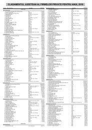
<strong>HCVF</strong> in Rio Bravo Conservation and Management Area6.3 HCV 4.3: Forest providing barriers to destructive firesBackground and Information SourcesThe pine savannah (10,000 ha) is the ecosystem most susceptible to fires. Every year, at least one or twofires are detected in the savannah ecosystem (10,000 ha or 10%) of the Rio Bravo. Most are minor eventbecause of PfB’s staff rapid control but there is always the risk of a major catastrophe occurring. Most ofthese fires are human induced, but nature can also ignite the savannas. Some ecologists havesuggested that the savanna ecosystem requires a certain amount of fire to maintain its characteristics.Where fire is removed for long periods (5-10 years), it is possible that broad-leaf plant species canbecome established and further condition the soil to support other broad-leaf plant species (Rio BravoPine Savanna Management Plan 2003). This is not desirable as the savanna system is an importantaspect of the biodiversity of the area.Map 17: Fire RiskThis page was created using Nitro PDF trial software.To purchase, go to http://www.nitro<strong>pdf</strong>.com/38
<strong>HCVF</strong> in Rio Bravo Conservation and Management AreaThe sub-tropical moist (sm) broadleaf forest that covers most of the RBCMA is not prone to fires due tolimited understory litter, absence of major fuels and to their high moisture content. However, the burningof adjacent agricultural fields has affected the perimeter (not greater than 100m?) of the forest (map 17).These are normally one time event as the agriculturalists clear the forest for pastoral or cropland use.No major community is directly adjacent to the RBCMA and so the threat to homes is negligible. Adjacentto the San Felipe Savanna, there are pastures which are not prone to burning. From a biodiversity pointof view, the fires within the pine savannas need to be managed. One way is to ensure that natural firebreaks provided by riparian forests are maintained. These forests will help limit the spread of fires andso allow for management interventions to be implemented.Most fires occur in the dry season (March-May) when many creeks are dry or are at their lowest waterlevel. This condition allows fire to move from one side of the stream to the next if no other barrier exists,e.g. a strip of broadleaf riparian forest.Definition of HCV 4.3All forest areas of 125 meters or less which are adjacent to the savanna ecosystem and their internalwater systems will be considered a <strong>HCVF</strong>.Parameters and Threshold ConsideredGiven the narrow range of economic activities within the RBCMA that can increase the threat of fires, onlythe savannas and waterways will be assessed for this purpose (map 18 savanna buffer).Interpretation of HCV 4.3Categories of HCV 4.3 Interpretation Score Surface areaForests up to 125 meters adjacent to thesavannas including savanna galleryforestsHigh HCV 3 2,026 haRecommendation for <strong>HCVF</strong> ManagementThe natural vegetation cover adjacent to savanna and water ways must be maintained.Recommendation for <strong>HCVF</strong> MonitoringA proper record of fires, preferably geo-referenced, and their effect on the ecosystem should bemaintained.Fire lookout towers need to be strategically constructed and daily observations made during the dryseason for early detection and timely suppression of fires.This page was created using Nitro PDF trial software.To purchase, go to http://www.nitro<strong>pdf</strong>.com/39
<strong>HCVF</strong> in Rio Bravo Conservation and Management AreaMap 18: Savanna with bufferThis page was created using Nitro PDF trial software.To purchase, go to http://www.nitro<strong>pdf</strong>.com/40
<strong>HCVF</strong> in Rio Bravo Conservation and Management Area7.0 HCV 5 & 6 Forest areas fundamental to meeting the basicneeds (HCV 5) and traditional values (HCV 6) of local communitiesBackground and Information SourcesIn many parts of the world, including Belize, some communities are highly dependent on environment tomeet the basic needs of their livelihoods, such as food, medicinal plants, shelter, water and fuel and formaintaining their traditions and cultural identity. In Belize this is more the case in the extreme south ofthe country where the indigenous Maya communities are established because they have a close tie withthe land.In most of the central and northern part of the country, the people are not considered “indigenous” and inmany cases large areas have been deforested for commercial/industrial scale agriculture (sugar cane,rice, corn, beans, etc). In the 1830’s, a Maya/Mestizo group moved from Yucatan, Mexico andestablished large areas of sugar cane plantations in the northwest of Belize. This group demonstrates nocultural direct ties to the forest area of the Rio Bravo and the forest itself does not provide to them theirbasic need (Annex 13.3: Community Consultation).The major group, in terms of their effect on the environment, adjacent to the RBCMA is the Mennonitecommunity. They began arriving in Belize in the 1950’s with the purpose of setting up large agriculturalfarms and cattle ranches. The forest was not a place for sustenance and in order to develop their way oflife the forest has to be removed, and replaced with cash crops, such as corn, beans, sorghum, rice andgrasslands for cattle rearing. While clearing the forests, timber was harvested as a by-product of theagricultural activity; the select species of cedar, mahogany and known hard woods were used for houseconstruction (Per. comm. With Mr. John Bueckert of Blue Creek)A number of Mestizo communities are close to the RBCMA: San Felipe, Indian Church and San Carlos.These communities are dependent of small scale agriculture, daily labor with the Mennonites of BlueCreek and Shipyard and with other sectors of the country. Also, many of the people in these villages arerecent Central American immigrants with no direct cultural ties with the forest of the RBCMA.In the south and east of the Rio Bravo, the communities are of Creole descent and have some ties withthe forests that surround their communities. This was explained by Percival Cho after his review of thisdocument by saying that “Hunting is not allowed inside the RBCMA but game species are taken byhunters on the perimeter as a form of subsistence and to fulfill a sense of cultural identity. Hunting hasbeen a tradition in not only the indigenous villages of Toledo but also the Creole villages in the northespecially along the Belize river valley.”Two Creole communities in the southeast of the RBCMA: Rancho Dolores and Lemonal have expressedconcern over the controls placed by PfB on their cattle wandering into the reserve as they are normallyfree ranging. This is not seen by PfB as a critical need for these residents as other areas are available fortheir use. Also, the practice of free ranging cattle conflicts with the property rights of PfB since theRBCMA is a private property. Additionally, free ranging cattle are fair game for jaguars within the reserveand conflicts will arise when cattle are preyed upon by jaguars. We must note that the Rio Bravo doesnot have presently, or during historical times, any community living within it as the area has a long historyof private ownership.Definition and Threshold of HCV 5Rayden 2008 discusses the criteria for which a <strong>HCVF</strong> for social and cultural values will be invoked. Sincethere is no set threshold, various countries have decided on their own parameters and then assess forthese values. The main point of HCV 5 & 6 should be whether a significant segment of thecommunity depends on the forest for their basic materials (fodder, medicines, or buildingmaterial) and for their cultural manifestations and traditions and where no viable alternativeexists.This page was created using Nitro PDF trial software.To purchase, go to http://www.nitro<strong>pdf</strong>.com/41
<strong>HCVF</strong> in Rio Bravo Conservation and Management AreaAt the same time, any use of the forest needs to be sustainable if it is to be a <strong>HCVF</strong>.Rainforest Alliance in an assessment of the Siak District, Sumatra, Indonesia in 2005 applied a thresholdthat 25% of the local community must be dependent on the FMU for their basic social need (e.g. fodder,medicines, or building material) for HCV 5 to be identified in the FMU.Definition and Threshold of HCV 6Rainforest Alliance in an assessment of the Siak District, Sumatra, Indonesia in 2005 applied a thresholdthat 50% of the community or sub-group (e.g ethnic) consider candidate forest areas as having criticalcultural value for HCV 6 to be identified.Interpretation HCV 5 & 6The critical need to use the RBCMA by neighboring communities for their basic sustenance and to fulfilltheir cultural identity is not identified in this assessment. Belize still has at least 69% of its land areaunder some form of forest cover and agricultural land and urban areas account for only 16.7% and .05%respectively (Meerman & Sabido 2001). Forests cover is present in the vicinity of most rural communities.Of course, not all the forests are available for unregulated use. Also, the communities in the vicinity of theRBCMA are a part of the market economy and they do not have traditional/long-term association with theforest. Additionally, from colonial days (1700s) the lands that later became the RBCMA was privateproperty owned by a British Company, Belize Estate and Produce Co. and no permanent settlement wasestablished in the area.No written report or visible evidence of community members using any site or area as a religious/sacredsite within the RBCMA has been found. Ancient Mayan temples are numerous but these no longer haveany direct linkage with the extant populations surrounding the FMU. Common archaeological knowledgeis that these temples were abandoned for at least 1,000 years by their builders. However, care must betaken not disturb any Mayan site during logging operations and their location needs to be properlydocumented on the logging map. Their contribution to the general Belizean patrimony is of paramountimportance for cultural and economic reasons. These Mayan sites with their magnificent monuments arethe property of the Government and people of Belize and not for the private land owner of the area inwhich they are found (Ancient Monuments and Antiquities Act # 15 of 1995, Amendment #44 of 2002).Current information for HCV 5 and 6 was documented from thirteen (13) buffer communities and thirtyfourparticipants at two consultation workshops held in early November 2009 in the villages of San Felipeand Double Head Cabbage (Annex 3).Northern Buffer Communities (San Felipe Consultation) Basic Needs Issues:1. The guarantee of a water supply in the short, medium and long term; it serves as a watershed forthe NRL which is a source of irrigation water (good pH) for vegetable farmers in Indian Church andSan Carlos; also a source of fish protein to these and the other communities.2. Serves as an infrequent source of game meat to the communities when the animals leave thereserve; in San Felipe, the overflow of deer allows some families to get some income to pay forchildren’s education3. A source of oxygen for Mesoamerica and has a cleansing function of the atmosphere4. Serves as an educational, recreational and touristic destination for children and adults; tourismbrings foreign exchange and employment5. Serves as a refugia for migrant birds during the winter season in the North6. Serves as a source of medicinal plants, e.g. experience Mr. Susano of August Pine Ridge7. The RBCMA should be protected but a limitation is that good agricultural land is locked up andnot available to farmers of the area which no longer has needed farm land.8. Maintains the water flow for Rio Hondo and major creeks of the area (refer to issue # 1 above.This page was created using Nitro PDF trial software.To purchase, go to http://www.nitro<strong>pdf</strong>.com/42
<strong>HCVF</strong> in Rio Bravo Conservation and Management AreaBelize River Valley (BelRiv) Consultation held in Double Head Cabbage Needs Issues:1. Hunting, farming and timber harvest are traditional ways of life for most communities in the pastbut no longer possible since the RBCMA was established; hunting needs to be controlled byestablishing limits for each hunter (a quota system should be introduced).2. A micro-credit program for Small Businesses for the buffer communities can substitute for thetraditional livelihoods mentioned in #1.3. A service of machinery for mechanized intensive small farming activities with irrigation will alsosubstitute for #1 issues; assistance to women with chicken rearing and wild game farming can bedone- PfB can donate initial breeding stock; technical assistance needed.4. Need for more jobs from PfB; needs for medicinal plants which have a market in Belize City.5. Riverine forests in the buffer communities need replanting to prevent erosion; will be areplication of what is done in the RBCMA aquatic ecosystems.6. Timber becomes very scarce and there is need for PfB to assist the buffer communities; askedfor clarification on why timbering continues at the RBCMA when the forests were over-harvestedin the past; RIL was explained.7. Need scholarships for high school children (PfB does it on request and if funds from otherpartners are available.8. There is widespread and genuine support for conservation; RBCMA can serve as a trainingcenter on how to “keep greening” the BelRiv area.9. Can assistance be given to raise Tilapia?All thirteen communities represented at the consultations expressed their support for conservation of theforests of the RBCMA. However, while the consultation in San Felipe was more supportive of theconservation activities and the long term benefit from them, a number of the Double Head Cabbageparticipants supported conservation of the RBCMA but addressed more the need for current and directbenefits to their communities as was given to them by PfB in its first Outreach Program in the early1990’s. Today the GOB is addressing the social issues under the its Poverty Alleviation Program, ofwhich education is of highest importance, and PfB may contribute to this social need, if and whenrequested and as long as there are available funding from international partners.It can therefore be concluded that for HCV #5, their basic needs do not depend on the RBCMA forests.With regards to HCV # 6, all thirteen communities agreed that they do not use the RBCMA forests for anytraditional cultural and spiritual needs.This page was created using Nitro PDF trial software.To purchase, go to http://www.nitro<strong>pdf</strong>.com/43
<strong>HCVF</strong> in Rio Bravo Conservation and Management Area8.0 HCV areas indentified in the FMUThe analyses with associated definitions as described above in sections HCV 1- 6 are summarized in thetable below. For each of the HCV’s the total area, the % of the entire area and the specific score is given.Forest Areas with HCVs Identified in the FMU (note FMU is entire RBCMA)Total Approx. (Ha) % of FMU Natural Forest ScoreHCV 1.1106,900 85% 2(Protected Areas)HCV 1.2 (Ecosystems for 106,90085% Forest 4IUCN species)10 % Pine Savanna, 35% Wetlands 3HCV 1.3 (Endemic Species) N.A. N.A. N.A.HCV 1.4 (Migratory birds) 89,800 85% 3HCV 2 (Biological Corridor 89,800 85% 3HCV 3 (Savanna for YH 10,000 9.3% 3Parrot)HCV 4.1 (Stream buffers) 1,690 1.6% 3HCV 4.2 (Slope - steepness) 1,440 1.3% 3HCV 4.3 (Savanna firebuffer)2,026 1.9% 3This page was created using Nitro PDF trial software.To purchase, go to http://www.nitro<strong>pdf</strong>.com/44
<strong>HCVF</strong> in Rio Bravo Conservation and Management Area9.0 Analysis of Conservation PrioritiesUsing a GIS analysis the layers used to identify the HCV’s 1-4 were combined into one layer and thespatial score added up into a single total value. The result of that is presented in map 19 below (Note: JanMeerman produced the layers and used them to do the analysis).Map 19: Total HCV scores RBCATo establish which of these values (ranging from 3 -18) should be considered “high” and which “low”, thestandard deviation of the mean was established with anything above 1 times standard deviationconsidered “high.”It should be noted that essentially the entire broadleaf section of the RBCMA came out “highish.” Thehigh HCV score for the Broadleaf section of the RBCMA is a direct consequence of this area being thekey area for the endangered species found in the Rio Bravo, the migratory birds and as well as it being(in its entirety) a critical component of the Northern Belize Biological Corridor. Essentially, most of theRBCMA is “special”. But within that area the zones with a score above 1 times standard deviation reallystand out.This page was created using Nitro PDF trial software.To purchase, go to http://www.nitro<strong>pdf</strong>.com/45
<strong>HCVF</strong> in Rio Bravo Conservation and Management AreaTo test how these high HCV relate to the current RBCMA management plan, the high HCV’s weresuperimposed on the management plan zonation map (map 20). This demonstrates clearly how theHCV’s are already zoned out for protection under the current management plan. The area with smalldiscrepancies is in the Cristal Creek logging zone which is dissected by an escarpment with steep slopes.Map 20. High HCV areas in relation to RBCMA management zoningThis page was created using Nitro PDF trial software.To purchase, go to http://www.nitro<strong>pdf</strong>.com/46
<strong>HCVF</strong> in Rio Bravo Conservation and Management Area10.0 <strong>HCVF</strong> Management and MonitoringThe scope of the assessment of the RBCMA was to identify HCVs and to compare how currentmanagement relates to the <strong>HCVF</strong>s. The new management plan required by 2011 will need to incorporatethe results of this assessment to ensure the maintenance of the <strong>HCVF</strong>s of the RBCMA.This document is in no way the final attempt to identify HCVs and is intended to be a starting point for thistool to be used by PfB in its sustainable forest management program. The recommendations formanagement and monitoring are not exhaustive and their implementation will depend on their thoroughanalysis and feasibility. Annex 4 brings together the management and monitoring recommendations.This page was created using Nitro PDF trial software.To purchase, go to http://www.nitro<strong>pdf</strong>.com/47
<strong>HCVF</strong> in Rio Bravo Conservation and Management Area11.0 ReferencesAncient Monuments and Antiquities Act # 15 of 1995, Amendment #44 of 2002Mallory, E. P., A. C. Vallely and N. Brokaw. 1998. Rapid Bird Assessment of the Rio Bravo Conservationand Management Area, Wings of the Americas. Manomet Center of Conservation Sciences,Manomet, Massachusetts, USA.Meerman, J., et. al. 2000. Feasibility Study of the Proposed Northern Belize Biological Corridor, NorthernBelize Biological Corridors Project, Progamme for Belize, Belize.Meerman, J. C. and W. Sabido. 2001. Central American Ecosystems Map. Vol. 1. Program For Belize,Belize.Meerman, J. C. 2007. Establishing a Baseline to Monitor Species and Key Biodiversity Areas inBelize. Critical Ecosystem Partnership Fund 15 pp.National Lands Act-Subsidiary, Cap 191, Revised Ed 2003.Nash, S. A. B. 2004. Nest-site selection in Yellow-headed Amazon parrots and the influence of poachingon site characteristics in Rio Bravo, Belize. A dissertation submitted to the University of EastAnglia, Norwich, for the degree of Master of Sciences in Applied Ecology and Conservation.Proforest. December 2003. The High Conservation Value Toolkit, Part 1.Programme for Belize. July 2006. Rio Bravo Conservation and Management Plan, Edition V, MainDocument, 2006-2010.Programme for Belize. July 2006. Rio Bravo Conservation and Management Plan, Edition V, Appendix,2006-2010.Programme for Belize. March 2008. Freshwater Programme <strong>Final</strong> Report to The Nature Conservancy.Programme for Belize. December 2003. Rio Bravo Pine Savanna Management Plan.Programme for Belize. February 2006. Forest Management Plan and Operational Guidelines 2006-2010.Rainforest Alliance/SmartWood. Interim standards for Assessing Forest Management in Belize,November 2008.Rainforest Alliance Smartwood Program. June 2005. High Conservation Value Forest (<strong>HCVF</strong>)Assessment Report for Siak District, Sumatra, Indonesia.Rayden T. April 2008. Assessment, management and monitoring of High Conservation Value Forest: Apractical guide for forest manager. Proforest. Oxford.Sabido, W. & D. Novelo. 2004. The endemic Rio Bravo Conservation and Management Area PineSavanna. A per for Winrock InternationalWultsch, C. December 2008. Non-invasive tracking of jaguars (Panthera onca) and co-occurring felinespecies in Belize by combining molecular scatology, remote camera trapping and GIS: the impactof fragmentation. <strong>Final</strong> Report to Programme for Belize. Dept. of Forestry and Wildlife Sciences,Virginia Polytechnic Institute and State University, VA, USA.This page was created using Nitro PDF trial software.To purchase, go to http://www.nitro<strong>pdf</strong>.com/48
<strong>HCVF</strong> in Rio Bravo Conservation and Management AreaWWF. 2008. Report of an <strong>HCVF</strong> landscape analysis pilot in an important and representative site for theconservation of the Upper Paraná Atlantic Forest in Paraguay: the San Rafael Reserve.12.0 AcknowledgementsWe thank Mr. Earl Green, Mr. Percival Cho, Dr. Bruce Miller, Mr. Jan Meerman and Mr. Edilberto Romero(PfB-Main Office) for their expert opinions and comments on this document. We thank Jan Meerman forputting together the maps and consolidating the final HCV scores. We also thank Anselmo Castañeda,Bladimir Rodriguez (PfB-La Milpa) and Efrain Cocom (PfB-Hillbank) for assisting with the communityconsultation workshops. A special thanks to Mr. Earl Panting, Chairman, Double Head Cabbage and Mr.Abel Celiz, Chairman, San Felipe for allowing us the use of their community centers.This page was created using Nitro PDF trial software.To purchase, go to http://www.nitro<strong>pdf</strong>.com/49
<strong>HCVF</strong> in Rio Bravo Conservation and Management Area13.0 ANNEXES13.1 Annex 1FSC PRINCIPLES AND CRITERIA FOR FOREST STEWARDSHIPFSC-STD-01-001 (version 4-0) ENApproved 1993Amended 1996, 1999, 2002Principle #9: Maintenance of high conservation value forestsManagement activities in high conservation value forests shall maintain or enhance the attributes whichdefine such forests. Decisions regarding high conservation value forests shall always be considered inthe context of a precautionary approach.9.1 Assessment to determine the presence of the attributes consistent with High Conservation ValueForests will be completed, appropriate to scale and intensity of forest management.9.2 The consultative portion of the certification process must place emphasis on the identifiedconservation attributes, and options for the maintenance thereof.9.3 The management plan shall include and implement specific measures that ensure the maintenanceand/or enhancement of the applicable conservation attributes consistent with the precautionary approach.These measures shall be specifically included in the publicly available management plan summary.9.4 Annual monitoring shall be conducted to assess the effectiveness of the measures employed tomaintain or enhance the applicable conservation attributes.This page was created using Nitro PDF trial software.To purchase, go to http://www.nitro<strong>pdf</strong>.com/50
<strong>HCVF</strong> in Rio Bravo Conservation and Management Area13.2 Annex 2FSC Definition of <strong>HCVF</strong>Rayden T. April 2008. Assessment, management and monitoring of High Conservation Value Forest:A practical guide for forest manager. Proforest. Oxford.<strong>HCVF</strong>s are those that possess one or more of the following attributes:Forest areas containing globally, regionally or nationally significant concentration of biodiversityvalues (e.g. endemism, endangered species, refugia); and /or large landscape level forests,contained within, or containing the management unit, where viable populations of most if not allnaturally occurring species exist in natural patterns of distribution and abundance.Forest area that are in or contain rare, threatened or endangered ecosystems.Forest area that provide basic services of nature in critical situations (e.g. watershed protection,erosion control).Forest area fundamental to meeting basic needs of local communities (e.g. subsistence, health)and/or critical to local communities’ traditional cultural identity (e.g. areas of cultural, ecological,economic or religious significance identified in cooperation with such local communities).This page was created using Nitro PDF trial software.To purchase, go to http://www.nitro<strong>pdf</strong>.com/51
<strong>HCVF</strong> in Rio Bravo Conservation and Management Area13.3 Annex 3: Community Consultation proceedingsProceedingsCommunity Consultations on the“High Conservation Value of the RBCMA Forests”San Felipe and Bermudian Landing,November 4 &5, 20091. INTRODUCTIONProgramme for Belize (PfB), formed in 1989, received the SMARTWOOD/WOODMARTCertification in 1997 and since then has abided by the nine (9) Criteria and Guidelines developedby the Forest Stewardship Council (FSC). Since 2007, the timber harvest, based on ReducedImpact Logging (RIL) guidelines/methodology, has been resumed and has consistently beingimproved at the field level.In 2009, the Sustainable Timber Harvest Team at PfB has seen the need to further develop andimprove the Management Plan and subsequently the Annual Operational Plans for thepreparation of the next Management Plan. This improvement has been based on thedevelopment of a new concept called “High Conservation Value Forests”. Also based on six (6)criteria/values developed by the FSC, this tool aims at seeking higher levels of forestmanagement that are managed sustainably from the economic, environmental and socialperspectives.The consultations carried out in early November 2009 were basically a validation exercisewhereby the participants were presented all six values with their respective components whichhave a technical and social/community focus. The objective of this exercise is for PfB to get theirinputs before finalizing the document. The technical issues/values (HCV 1-4) were based onscientific studies conducted at the RBCMA while the social/community values (HCV 5-6) neededmore substance from the communities who directly or indirectly depend on the RBCMA for part oftheir daily livelihood requirements.2. METHODOLOGYThe consultation process had a workshop setting with the following components:a. Agenda developed to guide the processb. Community leaders of villages buffering the northern and southern sectors of theRBCMA were invited by the Managers of Field Stations of La Milpa and Hill Bankc. Power Point Presentations were prepared showing all six HCV’s and these weresupported by mapsd. In each of the consultations, each community participant was given the opportunity toexpress those issues that he or she deemed necessary as community/socialparticipation for benefits from the Sustainable Timber Harvest Program at theRBCMA.3. THE WORKSHOPBoth workshops were called to order at 9:40am by the Technical Coordinator.After the Technical Coordinator had asked the participants to present themselves by communityand position they represent, he proceeded with explaining the explaining the workshop objectivesThis page was created using Nitro PDF trial software.To purchase, go to http://www.nitro<strong>pdf</strong>.com/52
<strong>HCVF</strong> in Rio Bravo Conservation and Management Areafollowed by a short description of what the RBCMA is and what are the various programscurrently being implemented within the property.In San Felipe there were 14 participants representing six villages of Mennonite and mostly ofMestizo descent. The presentation was made in Spanish and the participants were highlyinterested in the RIL by asking relevant questions of the methodology used by PfB.In Double Head Cabbage, with 20 participants representing seven communities, mostly of Creoledescent, there was less interest in RIL and mostly asked questions of direct benefits to thecommunities as was done in the first Outreach Program that PfB implemented in its early days ofestablishment when PfB was creating awareness and long term support for the RBMCA. TheOutreach Program then targeted primary school children, high school students and organizedadult groups who had interest in direct benefits from the Conservation Area. BEST was asked toassist in this programme.The six HCV’s as presented in the draft document taken for this consultation exercise was thenpresented by the consultant with assistance from the Technical Coordinator who used maps toconvey graphically the technical issues better. Using an easel with paper to write on, thesocial/community issues were documented as each participant made his/her input. Following arethe issues raised by the participants from the thirteen (13) communities.4. HIGH CONSERVATION VALUES 5 & 6For comparative purposes, the social/community issues raised by participants are presented intable format to make it clearer.HCV 5 refers to the “Basic Needs” while HCV 6 refers to the traditional use of the forest forcultural and spiritual needs of the people living in the buffer areas of the RBCMA.Examples of basic needs include the collection of fodder for their animals, building materials andmedicinal plants, among others.The San Felipe Consultation targeted the six northern buffer communities of San Carlos, IndianChurch, San Felipe, Blue Creek, Trinidad and San Lazaro.The Belize River Valley Consultation held in Double Head Cabbage targeted the seven southernbuffer communities of Rancho Dolores, Willows Bank, Double Head Cabbage, St. Paul’s Bank,Isabella Bank, Scotland Half Moon and Bermudian Landing.Table 1 Communities’ Basic Needs Satisfied by the Forests of the RBCMASan Felipe Double Head Cabbage Comments1. Hunting, farming and timberharvest are traditional ways oflife for most communities in thepast but no longer possible sincethe RBCMA was established;hunting needs to be controlledby establishing limits for eachhunter ( a quota system)1. The guarantee of a water supply inthe short, medium and long term; itserves as a watershed for the NRLwhich is a source of irrigation water(good pH) for vegetable farmers inIndian Church and San Carlos; alsoa source of fish protein to these andthe other communities.2. Serves as an infrequent source ofgame meat to the communities whenthe animals leave the reserve; in SanFelipe, the overflow of deer allowssome families to get some income topay for children’s education3. A source of oxygen forMesoamerica and has a cleansingfunction of the atmosphere2. A micro-credit program forSmall businesses for the buffercommunities can substitute forthe traditional livelihoodsmentioned in #13. A service of machinery formechanized intensive smallfarming activities with irrigationwill also substitute for #1 issues;assistance to women withchicken rearing and wild gameNeed for inventorystudies before this canbe put in practice. TheRBCMA does not allowhunting in itsmanagement plans.BRDP does this type ofassistance with CreditUnions for rural areasPartnering with theArea Representative.SGP/UNDP, PACT etc.can result in a morepositive outlook fromthe buffer communitiesThis page was created using Nitro PDF trial software.To purchase, go to http://www.nitro<strong>pdf</strong>.com/53
<strong>HCVF</strong> in Rio Bravo Conservation and Management Area4. Serves as an educational,recreational and touristic destinationfor children and adults; tourismbrings foreign exchange andemployment5. Serves as a refugia for migrantbirds during the winter season in theNorth6. Serves as a source of medicinalplants, e.g. Mr. Susano of APR7. The RBCMA should be protectedbut a limitation is that goodagricultural land is locked up and notavailable to farmers of the areawhich no longer has needed farmland8. Maintains the water flow for RioHondo and major creeks of the area(refer to issue # 1 abovefarming can be done- PfB candonate initial breeding stock;technical assistance needed4. Need for more jobs from PfB;needs for medicinal plants whichhave a market in Belize City5. Riverine forests in the buffercommunities need replanting toprevent erosion; this will be areplication of what is done in theRBCMA’s reverine ecosystems6. Timber becomes very scarceand there is need for PfB toassist the buffer communities;asked for clarification on whytimbering continues at theRBCMA when the forests wereover-harvested in the past; RILwas explained7. Need scholarships for highschool children.8. There is widespread andgenuine support forconservation; RBCMA can serveas a training center on how to“keep greening” the Belriv area9. Can assistance be given toraise Tilapia?towards the RBCMAforestsJobs are limited at theRBCMA but projects inthe villages can keepthem busy and alsoearn a livingThis is compatiblewithin HCV #5 and willbenefit the communitiessince all have a river orcreek adjacent to themThis may be difficult butsmall reforestationparcels at each villagemay be the answerPfB does it on requestand if funds from otherpartners are available.PfBmakespresentations on theRBCMA to schools onrequest.A Second OutreachProgram can addressthisEducation of buffercommunities can be apowerful tool to garnermore support forsustainably managedforests at the RBCMATilapia is an exoticspecies and thus PfBdoes not assist with itsfarming based onConservationprinciples.NB: The Technical Coordinator felt that the intended objective of the workshop was achievedusing this methodology.All thirteen communities represented at the consultations expressed their support forconservation of the forests of the RBCMA. However, while the consultation with the northernbuffer communities held in San Felipe was more supportive of the conservation activities and thelong term benefit from them, the Belize River Valley participants addressed more the need forcurrent and direct benefits to the communities as was given to them by PfB in its first OutreachProgram in the early 1990’s. It can therefore be concluded that for HCV #5, their basic needs donot depend on the RBCMA forests.With regards to HCV # 6, all thirteen communities agreed that they do not use the RBCMAforests for any traditional cultural and spiritual needs.This page was created using Nitro PDF trial software.To purchase, go to http://www.nitro<strong>pdf</strong>.com/54
<strong>HCVF</strong> in Rio Bravo Conservation and Management Area5. VOTE OF THANKSThe Station Managers of both La Milpa and Hill Bank thanked the community representatives fortheir attendance and participation, the Village Council Chairs for the use of their CommunityCenters and the other people who assisted with food preparation.This page was created using Nitro PDF trial software.To purchase, go to http://www.nitro<strong>pdf</strong>.com/55
<strong>HCVF</strong> in Rio Bravo Conservation and Management AreaAttachment 1: Community Consultation AgendaAGENDACommunity Consultation on the“RBCMA High Conservation Values of the Rio Bravo Forests”San Felipe and Double Head CabbageNovember 4 & 5, 20099:00 am Registration of Participants9:30 am Introduction of Participants9:40 am Workshop ObjectivesMr. Ramon Pacheco, PfB Technical Coordinator9:45 am Introduction to the PfB and the Rio BravoMr. Ramon Pacheco, PfB Technical Coordinator10:00 am BREAK-Snacks10:30 am Power Point Presentation of DocumentMr. Anselmo Castaneda11:45 am Plenary Session to discuss findings and receive inputs from Participants12: 30 pm Lunch1:30 pm If necessary, continue Plenary Session to discuss findings and receive inputs fromParticipants.Vote of thanksMr. Vladimir Rodriguez for San Felipe WorkshopMr. Efrain Cocom for Double Head WorkshopThis page was created using Nitro PDF trial software.To purchase, go to http://www.nitro<strong>pdf</strong>.com/56
<strong>HCVF</strong> in Rio Bravo Conservation and Management AreaAttachment 2A Consultation Date: 4 th November 2009Northern Buffer Communities held in San Felipe(14 Participants from Six Communities)NAME COMMUNITY CONTACT INFOGustavo PerezSan CarlosIsidoro Perez San Carlos 666-1526Francisco Queme Trinidad Village 309-7028Agileo Medina Trinidad Village noneMareli Celiz San Felipe 630-1632 (mareli_celiz@yahoo.com)Guenda Moguel San Lazaro noneIsidora Flota San Lazaro 667-7350Magdaleno Corado Indian Church 661-1541Raul Magana San Felipe 668-7098Jose David Gonzales Indian Church 603-1068John H. Bueckert Blue Creek 672-0324Oswaldo Dominguez San Felipe 664-9600Vladimir Rodriguez La Milpa Manager 627-3272Rudy Ramirez PFB Guide 668-4399This page was created using Nitro PDF trial software.To purchase, go to http://www.nitro<strong>pdf</strong>.com/57
<strong>HCVF</strong> in Rio Bravo Conservation and Management AreaAttachment 2B Consultation Date: 5 th November 2009Belize River Valley (BELRIV) Communitiesheld in Double Head Cabbage(20 participants from Seven Communities)NAME COMMUNITY CONTACT INFOGodfrey Pook Rancho Dolores 627-2598Eugene McFadzen Willow’s Bank 623-3166Earl Panting Double Head Cabbage 209-2106Elroy Herrera Rancho Dolores 209-2016Horell Nicholas Double Head Cabbage noneKent Thompson St. Paul’ Banks 220-2194Calbert Dawson Scotland Half Moon noneOlivia Rhaburn Scotland Half Moon 609-4663Patricia Lanza Isabella Bank 665-0000Orlin Casasola St. Paul’s Bank noneDwight McFadzen Double Head Cabbage noneJuan Herrera Isabella Bank 209-2209Janet Williams Double Head Cabbage 220-2218Jannine Thompson Double Head Cabbage 621-1709Efrain Cocom Hill Bank Field Station 623-3046Rick Mena Hill Bank Field Station noneRudy Balan Hill Bank Field Station noneRichard Balan Hill Bank Field Station noneCalbert Pook Rancho Dolores noneCurlin Flowers Bermudian Landing 665-9798This page was created using Nitro PDF trial software.To purchase, go to http://www.nitro<strong>pdf</strong>.com/58
12.4 Annex 4: Recommendations for Management and MonitoringHCV 1.1Protected AreasRecommendations for <strong>HCVF</strong> Management1 Maintain management presence/patrols in the entire RBCMA and clearly demarcate boundary, especially in hotspots.2 Liaise with government to institute proper management of the Aguas Turbias National Park. This will ensure landscape connectivity innorthwest Belize and buffer the core protection zone of the RBCMA.3 Liaise with managers of the Spanish Creek Wildlife Sanctuary. This will ensure landscape connectivity in south east Belize and buffer thecore protection zone of the RBCMA.4 Continue working with the Tri-National Coordinating Group of the Selva Maya Project.Recommendation for <strong>HCVF</strong> Monitoring1 Maintain records of boundary patrols.2 Be highly disciplined in carrying out management/forestry practices and verify forest condition through annual audits of impacted areas.HCV 1.2 Threatened or Endangered SpeciesRecommendation for <strong>HCVF</strong> Management1 Endangered species are a conservation priority; their management and the management of their habitats should be supported by employingthe best practices in extraction activities and the latest information on the species.2 Further surveys of flora and fauna should be encouraged whenever possible, particularly of lesser known taxonomic groups: insects, fungi,orchids, aquatic organisms and non-woody species.Recommendation for <strong>HCVF</strong> Monitoring1 Identify and clearly demarcate endangered tree species, particularly mature trees, during stock survey so that steps can be taken to avoidundue damage to the tree during harvest.2 Permanent sample plots and sampling of harvested plots should be done, based on available resources, so that the effects of harvest onthe mortality/survival of threatened species can be measured.3 Biodiversity studies should be encouraged so as to update the status of endangered species. This can be done at the species level throughthe engagement of research institutions and universities using indicator species e.g. birds, jaguars and/or bats.4 Continue active ranger patrols in the savannahs to protect yellow-headed parrots and their nestsHCV 1.4 Critical temporal useRecommendation for Management1 All important natural habitats for birds are substantially protected within the management system of PfB. Of the highest ranking vegetationtypes, riparian forests, upland forest (dry & mesic) and bajo are well represented in the protection zone and buffer zones. However, uplandmesic forest which ranks highly is within the timber extraction zone, the eastern RBCMA. Strict adherence to Reduced Impact Logging(RIL) guidelines and respect for buffers along waterways and bajos is necessary.35This page was created using Nitro PDF trial software.To purchase, go to http://www.nitro<strong>pdf</strong>.com/
<strong>HCVF</strong> in Rio Bravo Conservation and Management AreaRecommendation for <strong>HCVF</strong> Monitoring1 Monitoring of biodiversity, particularly the logging impacts on the bird population of the RBCMA, is essential to ensure that extractionactivities are sustainable. Birds, especially neotropical migrants of global concern, should be of particular interest as their presence can beused as an indicator of forest health.HCV 2 Globally, regionally or nationally significant large landscape level forestsRecommendation for <strong>HCVF</strong> Management1 The upland forest (dry and mesic) makes up the core protected area of the RBCMA and is mostly in the northwestern sector of the reserve.Protection against incursions and careful monitoring of non-timber forest product extraction, oil exploration activities and any other humanrelated activity need to be continued.2 The upland mesic forest is mostly in the eastern RBCMA and is the center for PfB’s Sustainable Timber Programme. Careful adherence toRIL guidelines, monitoring of logging impacts on tree growth and mortality, implementation of the Precautionary Principles and adaptivemanagement as prescribed in PfB’s management plan 2006-2010.3 Gallery and hammock forests will be qualified as HCVs because of their limited area and juxtaposition with less valued (from the point ofview of migrants and biological corridors) ecosystems, e.g. savanna.Recommendation for <strong>HCVF</strong> Monitoring1 Periodic monitoring of the RBCMA forests using aerial photography/over flights to access the integrity of the forest and direct ground patrolsto hotspots so that encroachment is prevented.HCV 3 Forest areas that are in or contain rare, threatened or endangered ecosystemsRecommendation for <strong>HCVF</strong> Management1 The forest manager must be aware, through continued research and updating of its vegetation map, for the different types of forest and theirimportant attributes. Given that the savannas have been mapped, the forest manager needs to implement a comprehensive firemanagement and pine rehabilitation program. Work on the populations of yellow-headed parrot, including nest site location in the SanFelipe savanna, preference, and chick survival should continue. If any extractive activity is planned for this area, RIL and BMP must beadhered to.Recommendation for <strong>HCVF</strong> Monitoring1 The forest manager should continue monitoring the pine savannah and yellow-headed parrot nests to ensure their protection.HCV 4 Forest areas that provide basic services of nature in critical situationsHCV 4.1 Forest critical to water catchmentsRecommendation for <strong>HCVF</strong> Management1 All that area, whether forested or not that fall within 125 meter from primary and secondary waterways will be excluded from the timberextraction zone and will be identified as a protection zone (buffer) on the RBCMA Zone map (map 14).Recommendation for <strong>HCVF</strong> Monitoring1 A post harvest assessment should be done yearly to monitor the degree of compliance in maintaining the protection zones.This page was created using Nitro PDF trial software.To purchase, go to http://www.nitro<strong>pdf</strong>.com/60
<strong>HCVF</strong> in Rio Bravo Conservation and Management AreaHCV 4.2 Forest critical to erosion controlRecommendation for <strong>HCVF</strong> Management1 The natural vegetation cover on escarpments and steep slopes be maintained, avoiding logging in areas with high erosion potential. Theoverlay of the Management Zones and the Slope Information (Map 16) show that there is some overlap. A reconnaissance of thesecompartments should be done before any timber operation and steep areas (>20 o) avoided.Recommendation for <strong>HCVF</strong> Monitoring1 A post harvest assessment should be done yearly to monitor the degree of compliance in maintaining the protection zones.HCV 4.3 Forest providing barriers to destructive firesRecommendation for <strong>HCVF</strong> Management1 The natural vegetation cover adjacent to savanna and water ways must be maintained to a minimum of 250 meters.Recommendation for <strong>HCVF</strong> Monitoring1 A proper record of fires incidents, preferably geo-referenced, and their impact on the ecosystem (e.g. area burnt) should be maintained.2 Fire lookout towers need to be strategically constructed and daily observations made during the dry season for early detection and timelysuppression of fires.This page was created using Nitro PDF trial software.To purchase, go to http://www.nitro<strong>pdf</strong>.com/61