Alafia River North Prong
Alafia River North Prong
Alafia River North Prong

You also want an ePaper? Increase the reach of your titles
YUMPU automatically turns print PDFs into web optimized ePapers that Google loves.
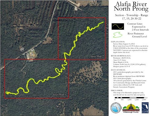
<strong>Alafia</strong> <strong>River</strong><strong>North</strong> <strong>Prong</strong>Section - Township - Range17, 19, 20-30-22Contour LinesExpressed in2-Foot Intervals<strong>River</strong> PerimeterGround LevelEXPLANATION:Survey Date:August 14, 2012<strong>River</strong> water level was 41.99 ft above sea level atUSGS 02301000 at the time of the assessmentNGVD29. Contours are expressed in absolutedepth below this level.Inset Map 2RIVER MORPHOLOGY:Perimeter 28,919.54 ft;Area 15.15 AcresMean Depth 4.32 ft;Volume 16.08 Acre-ft, (5,241,123.8 gallons);Deepest point 16.31 ftDATA SOURCES:2011 aerial photography provided by theSWFWMD.<strong>River</strong> perimeter digitized from SWFWMD2011 aerial photographs.All contours generated by the Florida Centerfor Community Design and Research fromsurvey data collected by USF Lake andStream Assessment Program.Inset Map 1DISCLAIMER:This map is for illustrative purposes only,and should not be used for lake navigation.Feet0 500 1,000 1,500 2,000
<strong>Alafia</strong> <strong>River</strong> <strong>North</strong> <strong>Prong</strong>Inset Map 16446686686164844666666Legend2-Foot ContoursPerimeter0 125 250 500 750 1,000Feet´
<strong>Alafia</strong> <strong>River</strong> <strong>North</strong> <strong>Prong</strong>Inset Map 24646844666644Legend2-Foot Contours4Perimeter640 125 250 500 750 1,000Feet´