Landslide hazard zonation in high risk areas of Rethymno ... - Springer
Landslide hazard zonation in high risk areas of Rethymno ... - Springer
Landslide hazard zonation in high risk areas of Rethymno ... - Springer

Create successful ePaper yourself
Turn your PDF publications into a flip-book with our unique Google optimized e-Paper software.
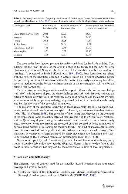
Nat Hazards (2010) 52:599–621 603Table 1 Frequency and relative frequency distribution <strong>of</strong> landslides <strong>in</strong> Greece, <strong>in</strong> relation to the lithologicaltype (Koukis et al. 1994, 2005) compared with the extend <strong>of</strong> the lithological types <strong>in</strong> the study areaLithological typeFrequency <strong>of</strong>landslides (%)Relative frequency <strong>of</strong>landslides (%)Extend (%) <strong>of</strong> the lithologicaltypes <strong>in</strong> the study areaLoose Quaternary deposits 20.65 12.99 15.87Neogene 28.20 11.74 24.00Flysch 30.35 35.75 8.48Schist-cherts 3.62 29.64 1.22Limestones, marbles 4.85 2.48 19.50Metamorphic 9.32 5.07 18.35Volcanic 3.00 2.37 12.58The area under <strong>in</strong>vestigation presents favorable conditions for landslide activity. Consider<strong>in</strong>gthe fact that the 20% <strong>of</strong> the area is occupied by flysch and the 22% by looseQuaternary deposits and Neogene, the frequency <strong>of</strong> the landslides can be expected to bevery <strong>high</strong>. As presented <strong>in</strong> Table 1 (Koukis et al. 1994, 2005), these formations are relatedwith the 80% <strong>of</strong> the landslides occurred <strong>in</strong> Greece. Based on <strong>in</strong>-situ observations, besidethe previously mentioned formations, with<strong>in</strong> the limits <strong>of</strong> the study area, many landslidesoccur <strong>in</strong> sections occupied by the weathered mantle <strong>of</strong> the metamorphic rocks and by thecalcitic rock formations.The extensive tectonic fragmentation and the repeated thrusts, the <strong>in</strong>tense morphologicalrelief with the steep slopes, the dense dra<strong>in</strong>age network with the deep valleys, theextensive human activities with the relatively dense road network, and the arable-irrigated<strong>areas</strong> are some <strong>of</strong> the preparatory and trigger<strong>in</strong>g causal factors <strong>of</strong> the landslides <strong>in</strong> the studyarea besides the type <strong>of</strong> the geological formations.The majority <strong>of</strong> the landslides occurr<strong>in</strong>g <strong>in</strong> loose Quaternary deposits, Neogene sediments,and weathered mantle <strong>of</strong> metamorphic rocks or flysch are translational—rotationalslides (Fig. 4a) (Varnes 1978). The extension <strong>of</strong> the slid<strong>in</strong>g area depends on the geometry<strong>of</strong> the slope and <strong>in</strong> some cases they affected <strong>areas</strong> reach<strong>in</strong>g up to 0.5 Km 2 (e.g., rotationalslide <strong>in</strong> Quaternary deposits along the Akoumia–Kria Vrisi road axis <strong>in</strong> the wider studyarea). Moreover, creep movements are recorded on <strong>areas</strong> covered by loose formations orby weathered mantles <strong>of</strong> metamorphic rocks or flysch. This k<strong>in</strong>d <strong>of</strong> movements, <strong>in</strong> somecases, it was recorded that they affected entire villages caus<strong>in</strong>g extended damages. Twocharacteristic examples, villages damaged by creep movements are Pantanasa and Apostoloifounded on the weathered mantles <strong>of</strong> metamorphic rocks (Fig. 4b, d).On <strong>areas</strong> occupied by rock formations (e.g., marbles and limestones) with very steepslopes, extensive debris flow are recorded (Fig. 4c). Planar slides or wedge failures alsooccur <strong>in</strong> these formations but they can be characterized as failures <strong>of</strong> local importance.3 Data used and methodologyThe different types <strong>of</strong> datasets used for the landslide <strong>hazard</strong> <strong>zonation</strong> <strong>of</strong> the area under<strong>in</strong>vestigation were as follows:1. Geological maps <strong>of</strong> the Institute <strong>of</strong> Geology and M<strong>in</strong>eral Exploration represent<strong>in</strong>glithological and structural units at 1:50000 scale (IGME 1985, 1991).123