Yosemite Online
Yosemite Online
Yosemite Online

Create successful ePaper yourself
Turn your PDF publications into a flip-book with our unique Google optimized e-Paper software.
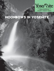
<strong>Yosemite</strong>. When the El Capital bridge was built in 1879, it was located across the narrow channel ofthe river between the two points of what remains of an old glacial terminal moraine.The river channel at this place was filled with large boulders, which greatly obstructed the freeoutflow of the flood waters in the spring, causing extensive overflows of the low meadow landabove, greatly interfering with travel, especially to <strong>Yosemite</strong> Falls and Mirror Lake. In order toremedy this matter, the large boulders in the river channel were blasted and the fragments leveleddown so as to give a free outflow of the flood waters. This increased the flow of the river currents,which now commenced greater eroding work on the river banks, and as the winding turns becamemore abrupt the destructive force annually increases. Some thorough system of protection should bepromptly used to save the river banks from further damage.A detailed study of the El Capitan Moraine dam was completed during the Fall of 1977 . Takingadvantage of the low water during this drought year, the observations revealed the locationof where Galen Clark blasted the moraine boulders in order to increase surface drainageand lower the water table . The study determined the width, length and depth of the blastedarea. By measuring boulder fragments, tributary stream terrace levels, conifer hierarchy' onthe stream terrace levels and surveying of six cross-sections of the Valley floor, the originalheight of the El Capitan Moraine prior to the blasting was determined . Since 1879, tributarystream channels have down-cut to an average depth of 4 .5 feet. This means that the presentriver gap in the El Capitan Moraine must be 4 .5 lower than in 1879 prior to Clark's blasting.This figure is important because the river-gap elevation represents the base-level of erosionfor the entire Central Chamber . Since 1879, the stream system's accelerated rate of degradationabove the moraine has remained unchecked.Photographs taken of <strong>Yosemite</strong> Valley by Watkins and Fiske in 1866, fifteen years before theEl Capitan Moraine was blasted, show photo after photo of heavily eroded stream banks fiveto six feet high, undermining trees and exposing roots of tall pines, cedars and oaks.Throughout geologic time, <strong>Yosemite</strong> Valley's stream system in the Central Chamber repeatedlyshifted its channel . Oxbow bends, abandoned stream channels and sloughs scar thefloors of every large meadow in <strong>Yosemite</strong> Valley . Swampy meadows developed in the depressionsof the fluvial scars . Stream bank erosion was as much a part of the aboriginal landscapein <strong>Yosemite</strong> Valley as the waterfalls.Despite the fact that the processes of lateral erosion were normal, early guardians and themanaging Board of Commissioners for <strong>Yosemite</strong> saw this natural phenomena as destructive to<strong>Yosemite</strong> meadows . In all actuality, no one noticed the river's dynamic character until itbegan to undermine bridges, roads and lodges constructed in the meander belt of the streamsystem . Galen Clark had begun the campaign of altering the pristine aboriginal riverscapeby rejuvenating stream degradation, while the Commission sought methods to halt lateralerosion.In 1882, the State Engineer, W . Hall, visited <strong>Yosemite</strong> Valley and inspected the river systemto suggest improvements at the Commissioners request. The following quotes are from hispamphlet, "To preserve from defacement and promote use of the <strong>Yosemite</strong> Valley" (1882).The following quotations document that braided reaches of channel existed and thatnumerous amounts of logs and unchecked lateral erosion were natural features in theriverscape.. . several notable obstructions lay in the river channel. Waters must be brought into one channel.. . above the Upper Iron Bridge, I found the river channel to be in especially bad condition, in fact,it divided up, spread out, obstructed and torturous in its course . . . result in unregulated overflow oflarge portions of available meadow lands in the Valley.. the streams of the Valley must be cleared and regulated.. Rivers are constantly demolishing their banks at some points and building up in others.From the above quotations one can get a good physical description of the river's behavior.Lateral erosion was very evident and was augmented by natural debris in the stream.Beginning in the early 1880's modern man installed the first physical amorment to protect thestream banks from eroding . Large granite boulders called rip-rap revetments are strategicallyplaced to cover entire sections of river bank subject to stream erosion . This type of armor requiresthousands of cubic yards of granite rock.In the fall of 1977, the first complete inventory of all artificial structures found in theriverscape of <strong>Yosemite</strong> Valley was completed.The total length of every rip-rap revetment site found in <strong>Yosemite</strong> Valley stream system wasmeasured. The total length came to 14,518 feet . To clarify the magnitude of this figure imagineturning the length vertically with the base at sea level . Comparing such a stack ofrevetment stones to the height of Mount Whitney leaves a tower of rip-rap some twenty-twofeet above the mountain top .
![(March 1982) [PDF] “We Are Pleased to Announce†- Yosemite Online](https://img.yumpu.com/51299748/1/190x242/march-1982-pdf-aeuroewe-are-pleased-to-announceaeur-yosemite-online.jpg?quality=85)
![[PDF] Old Horny, Yosemite's Unicorn Buck - Yosemite Online](https://img.yumpu.com/51269869/1/184x260/pdf-old-horny-yosemites-unicorn-buck-yosemite-online.jpg?quality=85)

![1985 [PDF] - Yosemite](https://img.yumpu.com/48128837/1/184x260/1985-pdf-yosemite.jpg?quality=85)