OutdoorIllinois March 2010 Fishing the Wabash - Illinois DNR
OutdoorIllinois March 2010 Fishing the Wabash - Illinois DNR
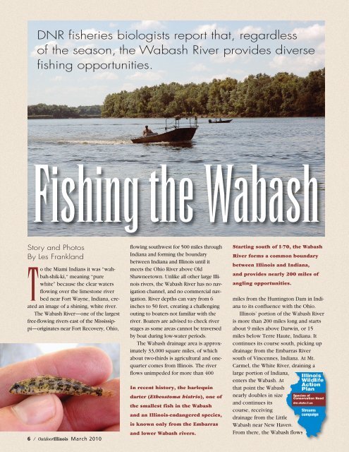
OutdoorIllinois March 2010 Fishing the Wabash - Illinois DNR

Create successful ePaper yourself
Turn your PDF publications into a flip-book with our unique Google optimized e-Paper software.
Canada geese settle on <strong>the</strong> banksof <strong>the</strong> <strong>Wabash</strong> River near Grayville(Edwards and White counties).A nearby, large, oxbow lake is apopular fishing destination.ano<strong>the</strong>r 15 miles, ending at <strong>Wabash</strong>Island on <strong>the</strong> Ohio River.Because of its unique qualities for alarge <strong>Illinois</strong> river, <strong>the</strong> <strong>Wabash</strong> supportsa diverse fishery. Fish speciesrange from small, endangered dartersto large paddlefish. Sport species presentinclude blue cat, channel cat, fla<strong>the</strong>adcat, white bass, black bass,striped bass, hybrid striped bass, smallmouthbass, spotted bass, largemouthbass, white crappie, black crappie,bluegill, freshwater drum and sauger.Carp—common, grass, bighead and silver—alsoare present.Catfish provide <strong>the</strong> best opportunitiesfor <strong>the</strong> angler and can be foundthroughout <strong>the</strong> river’s entire length.Smallmouth bass are found in <strong>the</strong>upper 100 miles of <strong>the</strong> river and spottedbass throughout its length. Latesummer and fall, when river levels arelow and <strong>the</strong> water clarity is improved,are <strong>the</strong> best time to seek black bass.Among <strong>the</strong> fish found in <strong>the</strong> <strong>Wabash</strong>River are paddlefish (below, held byMack Sitzes, fisheries technician)and blue cats (right, held by SteveJenkins, fisheries biologist).White, striped and hybrid stripedbass can be found throughout <strong>the</strong> river’slength but are more numerous in <strong>the</strong>lower 100 miles. Look for <strong>the</strong>se speciesfrom spring through early summer in <strong>the</strong>lower river around <strong>the</strong> numerous sandbarsand fast-water riffle areas.Sauger can be found throughout <strong>the</strong>river’s entire length. Those same sandbarsand fast-water riffles hold sauger<strong>March</strong> <strong>2010</strong> <strong>Outdoor<strong>Illinois</strong></strong> / 7
Although not as common as <strong>the</strong>ircousin <strong>the</strong> sauger, walleye area prized sport fish and present in<strong>the</strong> <strong>Wabash</strong> River.from late February through early April.Better fishing opportunities for largemouthbass, crappie and bluegill are in<strong>the</strong> oxbow lakes along <strong>the</strong> river.Formed when <strong>the</strong> river cut off largebends, <strong>the</strong>se oxbows serve as <strong>the</strong>boundary between Indiana and <strong>Illinois</strong>.A large oxbow lake, accessible to <strong>the</strong>public, can be found at Grayville. Thepaved boat ramp and parking area aremanaged by <strong>the</strong> City of Grayville.Although angling success can occuranywhere on <strong>the</strong> river, a few stretchesare especially well-known. Identified by<strong>Illinois</strong> locations are <strong>the</strong> river stretchesnear Mt. Carmel, Maunie and NewHaven. Indiana reaches include areasBeall Woods State Natural Area,located on <strong>the</strong> banks of <strong>the</strong><strong>Wabash</strong> River in sou<strong>the</strong>astern <strong>Illinois</strong>,has one of <strong>the</strong> few remaining tracts ofrelatively virgin timber east of <strong>the</strong> MississippiRiver. Besides hiking, BeallWoods offers camping, picnicking,fishing—and a chance to marvel attrees that are 120 feet high and morethan 3 feet in diameter.For fur<strong>the</strong>r information, write BeallWoods State Natural Area, 9285 BeallWoods Ave., Mount Carmel, IL 62863,phone (618) 298-2442 or visit dnr.state.il.us/lands/landmgt/parks/r5/beall.htm.near Vincennes and New Harmony.Boat access to <strong>the</strong> river can befound at <strong>the</strong> public boat ramps on <strong>the</strong><strong>Illinois</strong> and Indiana sides of <strong>the</strong><strong>Wabash</strong>. Public ramps on <strong>the</strong> <strong>Illinois</strong>side can be found at Hutsonville, Westport,St. Francisville, Mt Carmel,Grayville, Brown’s Pond near Maunieand New Haven via a 2-mile stretch of<strong>the</strong> Little <strong>Wabash</strong> River (see sidebar).The uniqueness of <strong>the</strong> <strong>Wabash</strong> Riverand its diverse fishery will provide <strong>the</strong>angler with many rewarding experiencesthat cannot be found on o<strong>the</strong>r<strong>Illinois</strong> waters.One of <strong>the</strong> largest islands in <strong>the</strong><strong>Wabash</strong>, Mink Island, nearMaunie in White County, providesa diverse fisheries habitat.Boundary river fishingOfficers of <strong>Illinois</strong> and Indiana willrecognize and accept valid sportfishing licenses of ei<strong>the</strong>r state whenlegally possessed and used on <strong>the</strong><strong>Wabash</strong> River forming a commonboundary between <strong>Illinois</strong> and Indiana.Anglers shall not fish on water beyond<strong>the</strong> natural and ordinary river banks of<strong>the</strong> state in which <strong>the</strong>y are not licensedto fish. Anglers shall not fish from landattached to or taxed by <strong>the</strong> state inwhich <strong>the</strong>y are not licensed or fish intributaries, bayous or backwaters of thatstate. Anglers must abide by <strong>the</strong> laws of<strong>the</strong> state in which <strong>the</strong>y are fishing.<strong>Wabash</strong> River accessareas in <strong>Illinois</strong>Darwin: Boaters may access <strong>the</strong> riverat <strong>the</strong> end of Franklin Street in Dawinfrom <strong>the</strong> ramp a farmer uses to ferryequipment across <strong>the</strong> river.Hutsonville: South of <strong>the</strong> Route 154bridge at Cherry and South WaterStreets are a paved boat ramp, parkinglot, picnic table and shelter.St. Francisville: This access site hasa paved boat ramp, dock, parking, picnictables, benches, shelter andportable restrooms.Mt. Carmel: Located south of 5thStreet, this access area has a paved,double boat ramp and gravel parkinglot.Grayville City Access Site andMemorial Park: These paved boatramps and parking areas are managedby <strong>the</strong> City of Grayville and provideaccess to <strong>the</strong> cut-off dead river. Directaccess to <strong>the</strong> <strong>Wabash</strong> is located under<strong>the</strong> Interstate 64 bridge.8 / <strong>Outdoor<strong>Illinois</strong></strong> <strong>March</strong> <strong>2010</strong>