O m niSTAR® VBS/XP/HP and RTK GPS Receiver - SXBlue GPS ...
O m niSTAR® VBS/XP/HP and RTK GPS Receiver - SXBlue GPS ...
O m niSTAR® VBS/XP/HP and RTK GPS Receiver - SXBlue GPS ...

You also want an ePaper? Increase the reach of your titles
YUMPU automatically turns print PDFs into web optimized ePapers that Google loves.
Om<strong>niSTAR®</strong> <strong>VBS</strong>/<strong>XP</strong>/<strong>HP</strong> <strong>and</strong> <strong>RTK</strong> <strong>GPS</strong> <strong>Receiver</strong><br />
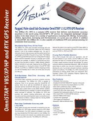
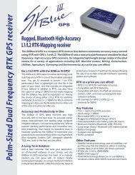
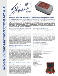
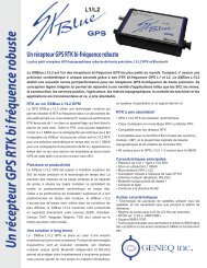
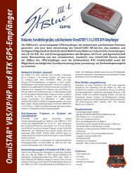
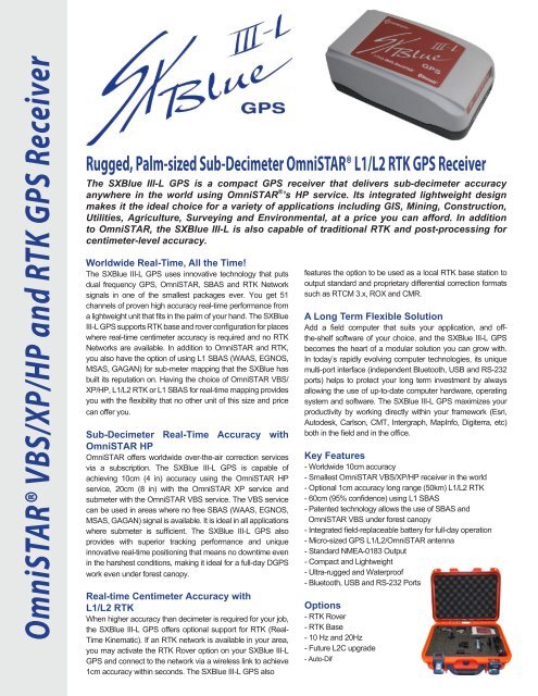
Rugged, Palm-sized Sub-Decimeter Om<strong>niSTAR®</strong> L1/L2 <strong>RTK</strong> <strong>GPS</strong> <strong>Receiver</strong><br />
The <strong>SXBlue</strong> III-L <strong>GPS</strong> is a compact <strong>GPS</strong> receiver that delivers sub-decimeter accuracy<br />
anywhere in the world using OmniSTAR ® ’s <strong>HP</strong> service. Its integrated lightweight design<br />
makes it the ideal choice for a variety of applications including GIS, Mining, Construction,<br />
Utilities, Agriculture, Surveying <strong>and</strong> Environmental, at a price you can afford. In addition<br />
to OmniSTAR, the <strong>SXBlue</strong> III-L is also capable of traditional <strong>RTK</strong> <strong>and</strong> post-processing for<br />
centimeter-level accuracy.<br />
Worldwide Real-Time, All the Time!<br />
The <strong>SXBlue</strong> III-L <strong>GPS</strong> uses innovative technology that puts<br />
dual frequency <strong>GPS</strong>, OmniSTAR, SBAS <strong>and</strong> <strong>RTK</strong> Network<br />
signals in one of the smallest packages ever. You get 51<br />
channels of proven high accuracy real-time performance from<br />
a lightweight unit that fits in the palm of your h<strong>and</strong>. The <strong>SXBlue</strong><br />
III-L <strong>GPS</strong> supports <strong>RTK</strong> base <strong>and</strong> rover configuration for places<br />
where real-time centimeter accuracy is required <strong>and</strong> no <strong>RTK</strong><br />
Networks are available. In addition to OmniSTAR <strong>and</strong> <strong>RTK</strong>,<br />
you also have the option of using L1 SBAS (WAAS, EGNOS,<br />
MSAS, GAGAN) for sub-meter mapping that the <strong>SXBlue</strong> has<br />
built its reputation on. Having the choice of OmniSTAR <strong>VBS</strong>/<br />
<strong>XP</strong>/<strong>HP</strong>, L1/L2 <strong>RTK</strong> or L1 SBAS for real-time mapping provides<br />
you with the flexibility that no other unit of this size <strong>and</strong> price<br />
can offer you.<br />
Sub-Decimeter Real-Time Accuracy with<br />
OmniSTAR <strong>HP</strong><br />
OmniSTAR offers worldwide over-the-air correction services<br />
via a subscription. The <strong>SXBlue</strong> III-L <strong>GPS</strong> is capable of<br />
achieving 10cm (4 in) accuracy using the OmniSTAR <strong>HP</strong><br />
service, 20cm (8 in) with the OmniSTAR <strong>XP</strong> service <strong>and</strong><br />
submeter with the OmniSTAR <strong>VBS</strong> service. The <strong>VBS</strong> service<br />
can be used in areas where no free SBAS (WAAS, EGNOS,<br />
MSAS, GAGAN) signal is available. It is ideal in all applications<br />
where submeter is sufficient. The <strong>SXBlue</strong> III-L <strong>GPS</strong> also<br />
provides with superior tracking performance <strong>and</strong> unique<br />
innovative real-time positioning that means no downtime even<br />
in the harshest conditions, making it ideal for a full-day D<strong>GPS</strong><br />
work even under forest canopy.<br />
Real-time Centimeter Accuracy with<br />
L1/L2 <strong>RTK</strong><br />
When higher accuracy than decimeter is required for your job,<br />
the <strong>SXBlue</strong> III-L <strong>GPS</strong> offers optional support for <strong>RTK</strong> (Real-<br />
Time Kinematic). If an <strong>RTK</strong> network is available in your area,<br />
you may activate the <strong>RTK</strong> Rover option on your <strong>SXBlue</strong> III-L<br />
<strong>GPS</strong> <strong>and</strong> connect to the network via a wireless link to achieve<br />
1cm accuracy within seconds. The <strong>SXBlue</strong> III-L <strong>GPS</strong> also<br />
features the option to be used as a local <strong>RTK</strong> base station to<br />
output st<strong>and</strong>ard <strong>and</strong> proprietary differential correction formats<br />
such as RTCM 3.x, ROX <strong>and</strong> CMR.<br />
A Long Term Flexible Solution<br />
Add a field computer that suits your application, <strong>and</strong> offthe-shelf<br />
software of your choice, <strong>and</strong> the <strong>SXBlue</strong> III-L <strong>GPS</strong><br />
becomes the heart of a modular solution you can grow with.<br />
In today’s rapidly evolving computer technologies, its unique<br />
multi-port interface (independent Bluetooth, USB <strong>and</strong> RS-232<br />
ports) helps to protect your long term investment by always<br />
allowing the use of up-to-date computer hardware, operating<br />
system <strong>and</strong> software. The <strong>SXBlue</strong> III-L <strong>GPS</strong> maximizes your<br />
productivity by working directly within your framework (Esri,<br />
Autodesk, Carlson, CMT, Intergraph, MapInfo, Digiterra, etc)<br />
both in the field <strong>and</strong> in the office.<br />
Key Features<br />
- Worldwide 10cm accuracy<br />
- Smallest OmniSTAR <strong>VBS</strong>/<strong>XP</strong>/<strong>HP</strong> receiver in the world<br />
- Optional 1cm accuracy long range (50km) L1/L2 <strong>RTK</strong><br />
- 60cm (95% confidence) using L1 SBAS<br />
- Patented technology allows the use of SBAS <strong>and</strong><br />
OmniSTAR <strong>VBS</strong> under forest canopy<br />
- Integrated field-replaceable battery for full-day operation<br />
- Micro-sized <strong>GPS</strong> L1/L2/OmniSTAR antenna<br />
- St<strong>and</strong>ard NMEA-0183 Output<br />
- Compact <strong>and</strong> Lightweight<br />
- Ultra-rugged <strong>and</strong> Waterproof<br />
- Bluetooth, USB <strong>and</strong> RS-232 Ports<br />
Options<br />
- <strong>RTK</strong> Rover<br />
- <strong>RTK</strong> Base<br />
- 10 Hz <strong>and</strong> 20Hz<br />
- Future L2C upgrade<br />
- Auto-Dif
Specifications<br />
<strong>GPS</strong> Sensor<br />
<strong>Receiver</strong> Type: L1/L2 <strong>GPS</strong> with OmniSTAR (<strong>VBS</strong>/<strong>XP</strong>/<strong>HP</strong>)<br />
Channels: 48 channels, parallel tracking<br />
12 x L1 C/A, 12 x L1P, 12 x L2C, 12 x L2P<br />
L-B<strong>and</strong> Support : 1 channel<br />
SBAS Support: 3 channels SBAS (WAAS, EGNOS, MSAS, GAGAN<br />
<strong>and</strong> compatible) or L1 C/A (when not tracking<br />
SBAS). Features SBAS Ranging.<br />
Update Rate: 1Hz default, optional 10Hz & 20Hz<br />
Cold Start: 60s (no almanac or RTC)<br />
Reacquisition: < 1s<br />
Maximum Speed: 1607 km/h (999mph)<br />
Maximum Altitude: 18,288m (60,000 ft)<br />
Accuracy RMS (67%) 2dRMS (95%)<br />
OmniSTAR <strong>HP</strong> 1, 7, 8 : 6cm 10cm<br />
OmniSTAR <strong>XP</strong> 1, 7, 8 : 12cm 20cm<br />
OmniSTAR <strong>VBS</strong> 1, 7 : Submeter<br />
<strong>RTK</strong> Horizontal 1, 6 : 10mm + 1ppm 20mm + 1ppm<br />
Post-processing (Horizontal) 1 : 10mm + 1ppm<br />
SBAS 1<br />
: 30cm 60cm<br />
Autonomous 1 : 2.5m<br />
Communication<br />
Ports: Bluetooth, RS-232C, USB 2.0<br />
Bluetooth Transmission: Class 1, 250m typical range 2<br />
Bluetooth Frequency: 2.400 – 2.485 GHz<br />
Fully Bluetooth pre-qualified: Bluetooth 2.0<br />
Baud Rates: 4800 to 115200<br />
Data I/O Protocol: NMEA 183, Binary<br />
Data Output Datum: OmniSTAR <strong>VBS</strong>/<strong>XP</strong>/<strong>HP</strong>: ITRF-2005<br />
(<strong>VBS</strong> in North America: NAD 83 Original)<br />
Autonomous: WGS 84 (G1150)<br />
SBAS: ITRF-2000<br />
Local Correction: Follows datum of corrections<br />
Timing Output: 1 PPS (HCMOS, active high, rising edge sync,<br />
10 kOhms, 10 pF load) 3<br />
Event Marker Input: HCMOS, active low, falling edge sync,<br />
10 kOhms, 10 pF load 3<br />
Raw Measurement Data: Proprietary binary (Free RINEX utility)<br />
Correction I/O Protocol 4 : RTCM 2.3, 3.x, CMR, CMR+, ROX<br />
<strong>GPS</strong> Status LED: Power, <strong>GPS</strong> Lock, D<strong>GPS</strong>/<strong>RTK</strong> Position,<br />
D<strong>GPS</strong>/<strong>RTK</strong> Lock, Bluetooth connection<br />
Battery Status LED: 5 LED’s bar graph<br />
Power<br />
Battery type: Field replaceable Lithium-Ion pack<br />
(Rechargeable in or outside of unit)<br />
Battery Capacity: 3,900mAh. 7.2V<br />
(Average autonomy: 7+ hours)<br />
Power Consumption: < 3.8W<br />
Charging Time: 4-5 hours (with supplied charger)<br />
Antenna Voltage Output: 5 VDC<br />
8047, Jarry East, Montreal<br />
(QC), H1J 1H6, Canada<br />
P: +1.514.354.2511<br />
1.800.463.4363 (Canada <strong>and</strong> USA)<br />
F: +1.514.354.6948 E: info@geneq.com<br />
www.sxbluegps.com<br />
www.geneq.com<br />
Environmental<br />
Operating Temperature: -40°C to +85°C (-40°F to +185 °F) 5<br />
Storage Temperature: -40°C to +85°C (-40°F to +185 °F)<br />
Humidity: 95% non-condensing<br />
Compliance: FCC, CE, RoHS <strong>and</strong> Lead-free<br />
Mechanical<br />
Enclosure Material: Re-enforced Nylon<br />
Battery Case Material: ABS<br />
Enclosure Rating: Waterproof, IP-67<br />
Immersion: 30cm, 30 minutes<br />
Enclosure Dimensions: 14.1 x 8.0 x 5.6 cm (5.57 x 3.15 x 2.22 in.)<br />
Weight (with battery) : 517 g (1.14 lbs)<br />
Data Connectors: DB-9 Female - USB Type B Female<br />
Antenna Connector: SMA Female<br />
Antenna<br />
<strong>GPS</strong> Freq Range: 1575 MHz ± 13 MHz, 1227 MHz ± 13 MHz<br />
L-B<strong>and</strong> Freq Range: 1525 – 1560 MHz<br />
Impedance 50 OHMs<br />
Gain (no cable): 33dB ±2dB<br />
Noise Figure: 1.9dB Max<br />
Voltage/Current: 2.5-24Vdc/