
You also want an ePaper? Increase the reach of your titles
YUMPU automatically turns print PDFs into web optimized ePapers that Google loves.
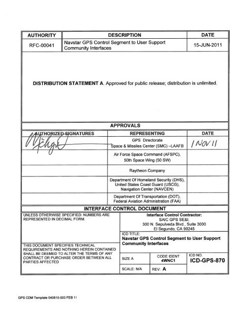
AUTHORITY DESCRIPTION I DATE<br />
RFC-00041<br />
Navstar <strong>GPS</strong> Control Segment to User Support<br />
jommunaty Inteaces<br />
15-JUN-201 1<br />
DiSTRIBUTION STATEMENT A. Approved for public release; distribution is unlimited.<br />
IZEJGNATURES Z<br />
if<br />
TH<br />
INTERFACE<br />
APPROVALS<br />
REPRESENTING DATE<br />
<strong>GPS</strong> Directorate<br />
Space & Missiles Center (SMC) -LFB I 11<br />
Air Force Space Command (AFSPC),<br />
50th Space Wing (50 SW)<br />
Raytheon Company<br />
Department Of Homeland Security (DHS),<br />
United States Coast Guard (USCG),<br />
Navigation Center (NAVCEN) -<br />
Department Of Transportation (DOT),<br />
Federal Aviation Administration (FAA)<br />
CONTROL DOCUMENT<br />
UNLESS OTHERWISE SPECIFIED: NUMBERS ARE Interface Control Contractor:<br />
REPRESENTED IN DECIMAL FORM.<br />
TH1S DOCUMENT SPECIF1ES TECHNICAL<br />
REQUIREMENTS AND NOTHING HEREIN CONTAINED<br />
SHALL BE DEEMED TO ALTER THE TERMS OF ANY<br />
lCD TITLE:<br />
SAIC <strong>GPS</strong> SE&I,<br />
300 N. Sepulveda Blvd., Suite 3000<br />
El_Segundo,_CA_90245<br />
Navstar <strong>GPS</strong> Control Segment to User Support<br />
Community Interfaces<br />
I CODE IDENT CD NO.<br />
CONTRACT OR PURCHASE ORDER BETWEEN ALL SIZE A<br />
PARTIES AFFECTED 4WNCI <strong>ICD</strong>-<strong>GPS</strong>-<strong>870</strong><br />
f<br />
<strong>GPS</strong> CDM Template 040810-003 FEB 11<br />
SCALE: N/A<br />
j<br />
REV: A
(This page intentionally left blank.)<br />
i<br />
<strong>ICD</strong>-<strong>GPS</strong>-<strong>870</strong><br />
15 June 2011
REVISION RECORD<br />
LTR DESCRIPTION DATE APPROVED<br />
NC Initial Release August 13, 2010 August 13, 2010<br />
A Update data formats for OCX (RFC-<br />
00041), including adding the A-S Status<br />
and ESHS files. Add IA requirements<br />
(data integrity) for this interface (RFC-<br />
00045)<br />
June 15, 2011 November 01, 2011<br />
ii<br />
<strong>ICD</strong>-<strong>GPS</strong>-<strong>870</strong><br />
15 June 2011
TABLE OF CONTENTS<br />
1 SCOPE.................................................................................................................................. 3-1<br />
1.1 SCOPE .............................................................................................................................. 3-1<br />
1.2 KEY EVENTS .................................................................................................................... 3-2<br />
1.3 INTERFACE CONTROL DOCUMENT APPROVAL AND CHANGES ......................................... 3-2<br />
2 APPLICABLE DOCUMENTS .......................................................................................... 3-3<br />
2.1 GOVERNMENT DOCUMENTS ............................................................................................ 3-3<br />
2.2 NON-GOVERNMENT DOCUMENTS.................................................................................... 3-4<br />
3 REQUIREMENTS .............................................................................................................. 3-5<br />
3.1 INTERFACE IDENTIFICATION ............................................................................................ 3-5<br />
3.1.1 <strong>GPS</strong> Advanced Control Segment (OCX) ................................................................. 3-6<br />
3.1.2 <strong>GPS</strong> User and User-support communities ............................................................... 3-7<br />
3.2 INTERFACE DEFINITIONS ................................................................................................. 3-7<br />
3.2.1 Generation of Almanac Data ................................................................................... 3-7<br />
3.2.2 Generation of Operational Advisory Data ............................................................... 3-7<br />
3.2.3 Generation of NANU Data ...................................................................................... 3-8<br />
3.2.4 Generation of Anti-Spoofing Status ......................................................................... 3-8<br />
3.2.5 Data Distribution ...................................................................................................... 3-8<br />
3.2.6 <strong>GPS</strong> MCS to Civil <strong>GPS</strong> Users Interface (USCG/FAA) .......................................... 3-8<br />
3.2.7 <strong>GPS</strong> MCS to Military <strong>GPS</strong> Users Interface ............................................................. 3-8<br />
3.2.8 <strong>GPS</strong> MCS to the United States Notice to Airman Office Interface ......................... 3-9<br />
3.3 <strong>GPS</strong> MCS TO <strong>GPS</strong> USER SUPPORT COMMUNITY DATA INTEGRITY ................................ 3-9<br />
3.3.1 <strong>GPS</strong> CS to <strong>GPS</strong> User Support Community data distribution via web site .............. 3-9<br />
3.3.2 <strong>GPS</strong> CS to <strong>GPS</strong> User Support Community data distribution via automated interface<br />
3-10<br />
4 QUALITY ASSURANCE ................................................................................................. 4-10<br />
5 PREPARATION FOR DELIVERY ................................................................................ 5-10<br />
6 NOTES ............................................................................................................................... 6-11<br />
6.1 ACRONYMS AND ABBREVIATIONS ................................................................................. 6-11<br />
7 APPROVAL ....................................................................................................................... 7-14<br />
10 APPENDIX 1: NANU DATA FORMATS .................................................................... 7-1<br />
10.1 NOTICE ADVISORY TO NAVSTAR USERS ...................................................................... 7-1<br />
10.1.1 Scheduled Outages ................................................................................................... 7-1<br />
10.1.2 Unscheduled Outages ............................................................................................... 7-5<br />
10.1.3 General NANU Messages ........................................................................................ 7-7<br />
10.1.4 Other Messages ........................................................................................................ 7-8<br />
10.2 NANU NOTIFICATION TIMES ..................................................................................... 7-11<br />
10.3 NANU MESSAGE FORMAT ......................................................................................... 7-11<br />
10.3.1 NANU Header ....................................................................................................... 7-12<br />
10.3.2 NANU Section 1 .................................................................................................... 7-13<br />
iii<br />
<strong>ICD</strong>-<strong>GPS</strong>-<strong>870</strong><br />
15 June 2011
10.3.2.1 NANU Message Description .................................................................................................................... 7-14<br />
10.3.2.2 NANU Reference Information .................................................................................................................. 7-14<br />
10.3.2.3 Satellite Identification ............................................................................................................................... 7-15<br />
10.3.2.4 Outage Time ............................................................................................................................................. 7-15<br />
10.3.3 NANU Section 2 .................................................................................................... 7-16<br />
10.3.4 NANU Section 3 .................................................................................................... 7-16<br />
20 APPENDIX 2: OPERATIONAL ADVISORY DATA FILE .................................... 20-1<br />
20.1 OPERATIONAL ADVISORY .......................................................................................... 20-1<br />
20.2 OA HEADER. .............................................................................................................. 20-2<br />
20.3 OA SECTION 1 ............................................................................................................ 20-2<br />
20.4 OA SECTION 2 ............................................................................................................ 20-3<br />
20.5 OA SECTION 3 ............................................................................................................ 20-3<br />
30 APPENDIX 3: ALMANAC DATA FILES ................................................................. 30-1<br />
30.1 ALMANAC DESCRIPTION ............................................................................................ 30-1<br />
30.2 SEM ALMANAC PARAMETERS DEFINITION ................................................................ 30-1<br />
30.3 SV HEALTH WORD .................................................................................................... 30-1<br />
30.4 SEM ALMANAC FORMAT ........................................................................................... 30-3<br />
30.5 YUMA ALMANAC FORMAT ....................................................................................... 30-8<br />
40 APPENDIX 4: EXTENDED SIGNALS HEALTH STATUS FILES ...................... 40-1<br />
40.1 EXTENDED SIGNALS HEALTH STATUS ........................................................................ 40-1<br />
50 APPENDIX 5: ANTI-SPOOFING STATUS FILE ................................................... 50-1<br />
50.1 ANTI-SPOOFING STATUS ............................................................................................ 50-1<br />
60 APPENDIX 6: LETTERS OF EXCEPTION ............................................................. 60-1<br />
60.1 SCOPE ......................................................................................................................... 60-1<br />
60.2 APPLICABLE DOCUMENTS .......................................................................................... 60-1<br />
60.3 LETTERS OF EXCEPTION ............................................................................................. 60-1<br />
iv<br />
<strong>ICD</strong>-<strong>GPS</strong>-<strong>870</strong><br />
15 June 2011
TABLE OF FIGURES<br />
Figure 1 <strong>GPS</strong> CS to the <strong>GPS</strong> User Community ........................................................... 3-5<br />
Figure 10-1 FCSTDV NANU Message Template ........................................................ 7-2<br />
Figure 10-2 FCSTMX NANU Message Template ........................................................ 7-2<br />
Figure 10-3 FCSTEXTD NANU Message Template.................................................... 7-3<br />
Figure 10-4 FCSTSUMM NANU Message Template .................................................. 7-3<br />
Figure 10-5 FCSTCANC NANU Message Template ................................................... 7-4<br />
Figure 10-6 FCSTRESC NANU Message Template ................................................... 7-4<br />
Figure 10-7 FCSTUUFN NANU Message Template ................................................... 7-5<br />
Figure 10-8 UNUSUFN NANU Message Template ..................................................... 7-6<br />
Figure 10-9 UNUSABLE NANU Message Template ................................................... 7-6<br />
Figure 10-10 UNUNOREF NANU Message Template ................................................ 7-7<br />
Figure 10-11 General Message Format ...................................................................... 7-8<br />
Figure 10-12 USABINIT NANU Message Template .................................................... 7-9<br />
Figure 10-13 LEAPSEC NANU Message Template .................................................... 7-9<br />
Figure 10-14 LAUNCH NANU Message Template .................................................... 7-10<br />
Figure 10-15 DECOM NANU Message Template ..................................................... 7-10<br />
Figure 10-16 NANU Message Template ................................................................... 7-12<br />
Figure 10-17 NANU Header ...................................................................................... 7-13<br />
Figure 10-18 Message Description ........................................................................... 7-14<br />
Figure 10-19 Reference Information.......................................................................... 7-14<br />
Figure 10-20 Satellite Identification Information ........................................................ 7-15<br />
Figure 10-21 Outage Time ........................................................................................ 7-15<br />
Figure 10-22 NANU Section 2 ................................................................................... 7-16<br />
Figure 10-23 Contact Information .............................................................................. 7-16<br />
Figure 20-1 Sample Operational Advisory ................................................................. 20-1<br />
Figure 20-2 OA Header ............................................................................................. 20-2<br />
Figure 20-3 OA Section 1 .......................................................................................... 20-2<br />
Figure 20-4 OA Section 2 .......................................................................................... 20-3<br />
Figure 20-5 OA Section 3 .......................................................................................... 20-3<br />
Figure 30-1 SEM Data Sample for Current.al3 .......................................................... 30-3<br />
Figure 30-2 YUMA Almanac Data Sample For Current.alm ...................................... 30-9<br />
Figure 40-1 Extended Signals Health Status Data Sample ....................................... 40-1<br />
Figure 50-1 Sample of the Anti-Spoofing Status file (as.txt) ...................................... 50-1<br />
Figure 60-1 Letter of Exception ................................................................................. 60-1<br />
v<br />
<strong>ICD</strong>-<strong>GPS</strong>-<strong>870</strong><br />
15 June 2011
TABLES<br />
Table I Information Exchange Matrix ........................................................................... 3-6<br />
Table 10-I Scheduled Outages .................................................................................... 7-1<br />
Table 10-II Unscheduled Outages ............................................................................... 7-5<br />
Table 10-III Other Types of NANU Messages ............................................................. 7-8<br />
Table 10-IV NANU Notification Times ....................................................................... 7-11<br />
Table 30-I Six-Bit SV Health Word in Almanac ......................................................... 30-1<br />
Table 30-II SEM Almanac Description for Current.al3 ............................................... 30-4<br />
Table 30-III SEM Almanac Description for Current.bl330-Error! Bookmark not defined.<br />
Table 40-I Modernized Civil Signals .......................................................................... 40-1<br />
Table 40-II ESHS Description ................................................................................... 40-2<br />
vi<br />
<strong>ICD</strong>-<strong>GPS</strong>-<strong>870</strong><br />
15 June 2011
1 SCOPE<br />
1.1 Scope<br />
This Interface Control Document (<strong>ICD</strong>) defines the functional data transfer interface<br />
between the Global Positioning System (<strong>GPS</strong>) Control Segment (CS) and the <strong>GPS</strong> User<br />
and User-support communities for the <strong>GPS</strong> Next Generation Operational Control<br />
System (OCX). This <strong>ICD</strong> describes the data files that are transferred in this interface<br />
and the means by which these data files are distributed.<br />
The files that are generated by the <strong>GPS</strong> CS are: Almanacs (System Effectiveness<br />
Model (SEM), YUMA, and Extended Signals Health Status (ESHS)), Operational<br />
Advisories (OAs), Anti-Spoofing (A-S) Status, and Notice Advisory to Navstar Users<br />
(NANUs). The formats of these files are defined in the Appendices of this document.<br />
All data files transferred as described in this <strong>ICD</strong> are unclassified and are publicly<br />
releasable per the current <strong>GPS</strong> CS mode of operations and the 50 th SW Memorandum<br />
for Record - 2 SOPS <strong>GPS</strong> Public Release Policy.<br />
In order to continue to support legacy Users who may not be able to update their code,<br />
the .alm (YUMA), .al3 (SEM), and as.txt (A-S Status) file formats are not changing and<br />
legacy Users are assured that they will continue to use these file types in the OCX era<br />
without changes to their systems. At the same time, the <strong>GPS</strong> CS does announce that it<br />
does not intend to make future updates to these file formats: .alm, .al3 and as.txt. The<br />
<strong>GPS</strong> CS encourages new Users and existing Users migrate to the newer file formats<br />
(.blm, .bl3, as2.txt), and in the future may propose to remove these legacy file formats in<br />
future updates to <strong>GPS</strong> CS. The <strong>GPS</strong> CS shall still be required to coordinate a specific<br />
timeframe or process in a public ICWG for the removal of a currently supported file<br />
formats.<br />
The new or modified file formats: .nnu (updated NANU), .ale (new ESHS), .blm (new<br />
YUMA), .bl3 (new SEM), .oa1 (updated OA) , and .as2.txt (new A-S Status) handle a<br />
larger number of SVNs and/or PRNs and more clearly specify zero padding and<br />
whitespace so automated parsing can be done with less assumptions.<br />
The <strong>GPS</strong> CS is operated by the 2d Space Operations Squadron (2 SOPS),<br />
administratively organized under 50 th Space Wing (50 SW). The <strong>GPS</strong> User and Usersupport<br />
communities are comprised of the Department of Homeland Security (DHS)<br />
United States Coast Guard (USCG); Department of Transportation (DOT), Federal<br />
Aviation Administration (FAA); other Civil Users; and various Military <strong>GPS</strong> Users. The<br />
interfaces between the <strong>GPS</strong> CS and the USCG, FAA, other Civil Users, and the Military<br />
<strong>GPS</strong> User community are implemented using electronic mail (e-mail), Internet and<br />
SIPRNet. This <strong>ICD</strong> does not include detailed technical descriptions of the e-mail<br />
system, Internet or SIPRNet.<br />
In this document, from here on, the term CS, which stands for Control Segment, will be<br />
used instead of OCX where applicable. In the OCX era, the OCX System will be the<br />
<strong>GPS</strong> Control Segment; therefore, the CS will be performing the functions stated in this<br />
<strong>ICD</strong>.<br />
1<br />
<strong>ICD</strong>-<strong>GPS</strong>-<strong>870</strong><br />
15 June 2011
1.2 Key Events<br />
The major milestone for implementation of this interface is the initial operating capability<br />
of the <strong>GPS</strong> OCX system beginning with Effectivity 10 as defined in SS-CS-800.<br />
1.3 Interface Control Document Approval and Changes<br />
The Interface Control Contractor (ICC), designated by the <strong>gov</strong>ernment, is responsible<br />
for the basic preparation, approval, distribution, and retention of the <strong>ICD</strong> in accordance<br />
with the Interface Control Working Group (ICWG) charter GP-03-001.<br />
The following signatories must approve this <strong>ICD</strong> to make it effective.<br />
1. Air Force Space Command (AFSPC), <strong>GPS</strong> Directorate (GP) Space and<br />
Missile Systems Center (SMC)<br />
2. Air Force Space Command (AFSPC), 50 th Space Wing (50 SW)<br />
3. Raytheon Company, OCX Contractor<br />
4. Department of Homeland Security (DHS), United States Coast Guard<br />
(USCG), Navigation Center (NAVCEN)<br />
5. Department of Transportation (DOT), Federal Aviation Administration (FAA)<br />
Initial signature approval of this <strong>ICD</strong> can be contingent upon a letter of exception<br />
delineating those items by paragraph numbers that are not a part of the approval. Such<br />
letter of exception can be prepared by any of the signatories and must be furnished to<br />
the ICC for inclusion in the printed distribution of the officially released version of the<br />
<strong>ICD</strong>.<br />
Changes to the approved version of this <strong>ICD</strong> can be initiated by any of the signatories<br />
and must be approved by all above signatories. The ICC is responsible for the<br />
preparation of the change pages, change coordination, and the change approval by all<br />
signatories. Designated signatories can approve proposed changes to this <strong>ICD</strong> without<br />
any increase in the scope of a specific contract by so specifying in a letter of exception.<br />
Such letters of exception must be furnished to the ICC for inclusion in the released<br />
version of the approved change and in the printed distribution of the approved <strong>ICD</strong>.<br />
Whenever all of the issues addressed by a letter of exception are resolved, the<br />
respective signatory shall so advise the ICC in writing. When a portion of the<br />
exceptions taken by a signatory are resolved (but not all), the signatory shall provide the<br />
ICC with an updated letter of exception. Based on such notifications – without<br />
processing a proposed interface revision notice (PIRN) for approval – the ICC will omit<br />
the obsolete letter of exception from the next revision of the <strong>ICD</strong> and will substitute the<br />
new one (if required).<br />
The typical review cycle for a PIRN is 45 days after receipt by individual addressees<br />
unless a written request for a waiver is submitted to the ICC.<br />
2<br />
<strong>ICD</strong>-<strong>GPS</strong>-<strong>870</strong><br />
15 June 2011
2 APPLICABLE DOCUMENTS<br />
2.1 Government Documents<br />
The following documents of the issue specified contribute to the definition of the<br />
interfaces in this <strong>ICD</strong> and form a part of this <strong>ICD</strong> to the extent specified herein.<br />
Specifications<br />
Standards<br />
Federal<br />
None<br />
Military<br />
None<br />
Other Government Activity<br />
SS-CS-800<br />
Current Version<br />
<strong>GPS</strong> III Control Segment Specification Global Positioning<br />
Systems Wing (<strong>GPS</strong>W)<br />
Federal<br />
September 2008 Global Positioning System Standard Positioning Service<br />
Performance Standard<br />
July 2010 DoD IPv6 Standard Profiles For IPv6 Capable Products<br />
Version 5.0<br />
Military<br />
None<br />
Other Publications<br />
IS-<strong>GPS</strong>-200<br />
Current Version<br />
IS-<strong>GPS</strong>-705<br />
Current Version<br />
IS-<strong>GPS</strong>-800<br />
Current Version<br />
GP-03-001A<br />
20 April 2006<br />
MOA<br />
February 1992<br />
Navstar <strong>GPS</strong> Space Segment / Navigation User Interface<br />
Navstar <strong>GPS</strong> Space Segment / User Segment L5 Interfaces<br />
Navstar <strong>GPS</strong> Space Segment / User Segment L1C<br />
Interfaces<br />
<strong>GPS</strong> Interface Control Working Group (ICWG) Charter<br />
Memorandum of Agreement Between the United States<br />
Coast Guard and the United States Space Command,<br />
“Distribution of Navstar Global Positioning System (<strong>GPS</strong>)<br />
Status Information”<br />
(Signatories: USCG/G-NRN and USSPACECOM/DO)<br />
3<br />
<strong>ICD</strong>-<strong>GPS</strong>-<strong>870</strong><br />
15 June 2011
MOA<br />
February 1996<br />
MOA<br />
February 2010<br />
Support Agreement Between the United States Coast<br />
Guard and the United States Air Force Space Command,<br />
“Distribution of Navstar Global Positioning System (<strong>GPS</strong>)<br />
Status Information”<br />
(Signatories: Commanding Officer NAVCEN and<br />
AFSPC/DO)<br />
Memorandum of Agreement between the Joint Functional<br />
Component Command for Space the U.S. Coast Guard<br />
Navigation Center and the FAA National Operations Control<br />
Center with respect to the Support of Users of the Navstar<br />
Global Positioning System<br />
Fiscal Year 2008 Federal Radionavigation Plan<br />
MFR<br />
June 30, 2011<br />
Department of the Air Force, 50th Space Wing (AFSPC)<br />
Memorandum for Record - 2 SOPS <strong>GPS</strong> Public Release<br />
Policy<br />
2.2 Non-Government Documents<br />
The following documents of the issue specified contribute to the definition of the<br />
interfaces in this <strong>ICD</strong> and form a part of this <strong>ICD</strong> to the extent specified herein.<br />
Specifications<br />
None<br />
Standards<br />
None<br />
Other Publications<br />
None<br />
4<br />
<strong>ICD</strong>-<strong>GPS</strong>-<strong>870</strong><br />
15 June 2011
3 REQUIREMENTS<br />
3.1 Interface Identification<br />
This <strong>ICD</strong> defines the interfaces between the Global Positioning System (<strong>GPS</strong>) Control<br />
Segment and the <strong>GPS</strong> User and User-support communities during the <strong>GPS</strong> Next<br />
Generation Operational Control System (OCX) era. The files provided by the <strong>GPS</strong> CS<br />
to these <strong>GPS</strong> Users are the Almanacs, Operational Advisories (OAs), Anti-Spoofing (A-<br />
S) Status, and the Notice Advisory to Navstar Users (NANUs) corresponding to all<br />
legacy signals and the new Civil signals L1C, L2C and L5. The <strong>GPS</strong> CS provides these<br />
data files to a TBD Web Server, residing outside of OCX, for further distribution. The<br />
primary means for distribution of the data that is generated by the <strong>GPS</strong> CS is via<br />
electronic mail (e-mail), Internet and SIPRNet.<br />
Figure 1 captures the interfaces defined in this <strong>ICD</strong>. The point of demarcation<br />
separates the end Users from OCX and Department of Defense (DoD) systems that<br />
provide the files.<br />
Figure 1 <strong>GPS</strong> CS to the <strong>GPS</strong> User Community<br />
The interfaces defined in this <strong>ICD</strong> are listed in Table I, in the form of an information<br />
exchange matrix.<br />
5<br />
<strong>ICD</strong>-<strong>GPS</strong>-<strong>870</strong><br />
15 June 2011
Producer Consumer Data Exchange<br />
Identification<br />
<strong>GPS</strong> CS DHS USCG /<br />
DOT FAA/<br />
Other Civil<br />
Users*<br />
<strong>GPS</strong> CS DHS USCG /<br />
DOT FAA/<br />
Other Civil<br />
Users<br />
<strong>GPS</strong> CS DHS USCG /<br />
DOT FAA/<br />
Other Civil<br />
Users<br />
<strong>GPS</strong> CS DHS USCG /<br />
DOT FAA/<br />
Other Civil<br />
Users<br />
<strong>GPS</strong> CS Military User<br />
Community<br />
<strong>GPS</strong> CS Military User<br />
Community<br />
<strong>GPS</strong> CS Military User<br />
Community<br />
<strong>GPS</strong> CS Military User<br />
Community<br />
Table I Information Exchange Matrix<br />
<strong>GPS</strong> Status<br />
Information<br />
<strong>GPS</strong> Constellation<br />
Status Summary<br />
<strong>GPS</strong> Constellation<br />
Anti-Spoofing<br />
Status<br />
<strong>GPS</strong> Constellation<br />
Orbital and<br />
Performance<br />
Parameters, and<br />
SV Signal Health<br />
Status<br />
6<br />
Information<br />
Description<br />
Nature of<br />
Transaction<br />
NANU Transmit via<br />
E-Mail and Post to<br />
Internet Website<br />
OA Post to Internet<br />
Website<br />
A-S Status Post to Internet<br />
Website<br />
Almanac Post to Internet<br />
Website<br />
NANU Post to Internet<br />
and SIPRNet<br />
Websites<br />
OA Post to Internet<br />
and SIPRNet<br />
Websites<br />
A-S Status Post to Internet<br />
and SIPRNet<br />
Websites<br />
Almanac Post to Internet<br />
and SIPRNet<br />
Websites<br />
Note:<br />
* Automatic NANUs are also sent to other 2 SOPS approved <strong>GPS</strong> Users via e-mail<br />
Security<br />
Unclassified<br />
Unclassified<br />
Unclassified<br />
Unclassified<br />
Unclassified<br />
Unclassified<br />
Unclassified<br />
Unclassified<br />
3.1.1 <strong>GPS</strong> Control Segment<br />
The <strong>GPS</strong> CS is operated by the 2d Space Operations Squadron (2 SOPS),<br />
administratively organized under 50 th Space Wing (50 SW). The <strong>GPS</strong> CS operations<br />
are performed primarily via the Master Control Station (MCS), Alternate Master Control<br />
Station (AMCS), Monitor Stations (MS), and Ground Antennas (GA).<br />
The MCS, located at Schriever Air Force Base (SAFB), is the central control point for<br />
<strong>ICD</strong>-<strong>GPS</strong>-<strong>870</strong><br />
15 June 2011
the <strong>GPS</strong> CS. For this interface, the MCS is responsible for generating the Almanacs,<br />
OAs, A-S Status and NANUs and providing these files to the <strong>GPS</strong> Users and User<br />
support community. The AMCS, located at Vandenberg AFB (VAFB), is functionally<br />
identical to the MCS; either MCS facility is capable of indefinite control of the <strong>GPS</strong><br />
constellation. In case the MCS experiences downtime, the AMCS takes over this<br />
interface function. The term “MCS”, as now used throughout this document, refers to<br />
either the MCS or the AMCS, whichever MCS facility actively controls the <strong>GPS</strong><br />
constellation.<br />
The MSs and GAs do not play a role in this interface.<br />
3.1.2 <strong>GPS</strong> User and User-support communities<br />
The <strong>GPS</strong> User and User-support communities involve the Civil and Military <strong>GPS</strong> Users<br />
which are comprised of the Department of Homeland Security (DHS), United States<br />
Coast Guard (USCG); Department of Transportation (DOT), Federal Aviation<br />
Administration (FAA); other Civil Users; and various Military <strong>GPS</strong> Users. These <strong>GPS</strong><br />
Users are the recipients of the Almanac data, OAs, A-S Status and NANUs.<br />
3.2 Interface Definitions<br />
The following subsections define the functional requirements and physical interface<br />
between the <strong>GPS</strong> CS and the DHS USCG, DOT FAA, other Civil Users, and the Military<br />
<strong>GPS</strong> User Community. For this interface, the <strong>GPS</strong> CS will communicate using<br />
Transmission Control Protocol/Internet Protocol (TCP/IP) communications protocol.<br />
This interface will also be IPv6 capable as defined by DoD IPv6 standard profile 5.0.<br />
This <strong>ICD</strong> describes information exchanges between CS and the user support<br />
community at the functional (application) layer only, and does not describe the hardware<br />
and software configuration of the Internet or SIPRNet.<br />
3.2.1 Generation of Almanac Data<br />
The <strong>GPS</strong> CS generates the Almanac data for the <strong>GPS</strong> constellation, two current<br />
System Effectiveness Model (SEM) format Almanacs (current.al3 and current.bl3), two<br />
current YUMA format Almanacs (current.alm and current.blm), and one current<br />
Extended Signals Health Status (ESHS) format Almanac (current.ale). The satellite<br />
SEM and YUMA Almanac data contains orbital and performance parameters for<br />
operational <strong>GPS</strong> satellites. Detailed data formats of the SEM and YUMA Almanac data<br />
are described in Appendix 3 of this <strong>ICD</strong>. The satellite ESHS Almanac data contains the<br />
health status of each of the modernized civil signals available for each SV – L1C, L2C<br />
and L5. Detailed data formats of the ESHS Almanac data are described in Appendix 4<br />
of this <strong>ICD</strong>.<br />
3.2.2 Generation of Operational Advisory Data<br />
The <strong>GPS</strong> CS generates the Operational Advisory data (current.oa1) for the <strong>GPS</strong><br />
constellation. The OA data are descriptive summaries of <strong>GPS</strong> constellation status.<br />
7<br />
<strong>ICD</strong>-<strong>GPS</strong>-<strong>870</strong><br />
15 June 2011
Detailed data formats of the OA data are described in Appendix 2 of this <strong>ICD</strong>.<br />
3.2.3 Generation of NANU Data<br />
The <strong>GPS</strong> CS generates the NANU data file (current.nnu) for the <strong>GPS</strong> constellation. The<br />
NANU data are messages that inform Users of satellite outages and other <strong>GPS</strong> issues.<br />
Detailed data formats of the NANU data are described in Appendix 1 of this <strong>ICD</strong>.<br />
3.2.4 Generation of Anti-Spoofing Status<br />
The <strong>GPS</strong> CS generates the Anti-Spoofing Status files (as.txt and as2.txt) for the <strong>GPS</strong><br />
constellation. The A-S Status informs Users whether the Anti-Spoofing mode of each<br />
<strong>GPS</strong> SV is ON or OFF. Detailed data format of the A-S Status are described in<br />
Appendix 5 of this <strong>ICD</strong>.<br />
3.2.5 Data Distribution<br />
The <strong>GPS</strong> CS provides the NANU, Operational Advisory, Anti-Spoofing Status, and<br />
Satellite Almanac files to a TBD Web Server for further distribution to the Military and<br />
Civil User Support Communities via electronic mail (e-mail), and Internet and SIPRNet<br />
websites. Sections 3.2.6 and 3.2.7 describe these interfaces.<br />
3.2.6 <strong>GPS</strong> MCS to Civil <strong>GPS</strong> Users Interface (USCG/FAA)<br />
The <strong>GPS</strong> CS provides the NANU data file to a TBD Web Server for further distribution<br />
via automatic electronic mail (e-mail) distribution to an e-mail address provided by the<br />
USCG and FAA. Other 2 SOPS approved/authorized <strong>GPS</strong> Users also receive<br />
automatic NANUs.<br />
The <strong>GPS</strong> CS uploads the NANU, Operational Advisory, Anti-Spoofing Status, and<br />
Satellite Almanac files to the Constellation Status page of the 2d Space Operations<br />
Squadron (2 SOPS) Internet secured website, https://gps.afspc.af.mil/gps, that is hosted<br />
on a TBD Web Server. NANU messages are transmitted whenever they are generated<br />
including weekends and holidays. The OA, A-S Status, and Almanac files are normally<br />
uploaded to the 2 SOPS Internet website once per day, 24/7, 365 days a year, prior to<br />
1700 Zulu time (10 am MST, 11 am MDT). The USCG, FAA and other <strong>GPS</strong> Users,<br />
including Military Users and the general public, with Internet connectivity can access the<br />
2 SOPS website and download these data files using Hypertext Transfer Protocol<br />
Secure (HTTPS).<br />
3.2.7 <strong>GPS</strong> MCS to Military <strong>GPS</strong> Users Interface<br />
The Military <strong>GPS</strong> Users with Internet connectivity can access the 2 SOPS secured<br />
Internet website and download NANU, Operational Advisory, Anti-Spoofing Status, and<br />
Satellite Almanac files as described in Section 3.2.6.<br />
The <strong>GPS</strong> CS uploads the NANU, Operational Advisory, Anti-Spoofing Status, and<br />
Satellite Almanac files to the 2 SOPS SIPRNet website, that is hosted on a TBD Web<br />
8<br />
<strong>ICD</strong>-<strong>GPS</strong>-<strong>870</strong><br />
15 June 2011
Server, with the same frequency and timeline as for the Internet website as described in<br />
Section 3.2.6. Only authorized Military <strong>GPS</strong> Users with SIPRNet connectivity can<br />
download a NANU, OA, A-S Status, or Almanac data file using HTTPS.<br />
3.2.8 <strong>GPS</strong> MCS to the United States Notice to Airman Office Interface<br />
There is a data transfer interface between the CS and the United States NOTAM<br />
(Notice to Airmen) Office (USNOF) which is similar in content to the CS interface with<br />
the USCG and FAA. However, at this time, the CS to USNOF interface is defined and<br />
controlled by operational procedures and is not automated. Therefore, it is not included<br />
in this <strong>ICD</strong>. It is expected that a new automated interface between the CS and the<br />
USNOF will be added to this <strong>ICD</strong> in a future revision.<br />
3.3 <strong>GPS</strong> MCS to <strong>GPS</strong> User Support Community Data Integrity<br />
Those consumers not interested in verifying the data integrity of messages (NANUs,<br />
OAs, A-S status files, Almanacs, and ESHSs) can simply just use the messages. The<br />
requirement is upon the <strong>GPS</strong> CS to provide data integrity and it is OPTIONAL for the<br />
consumer to take the steps needed to verify the integrity of the data. The following<br />
paragraphs describe what the <strong>GPS</strong> CS is required to do and optionally what the<br />
consumer would need to do to verify that a message is genuine and originates from the<br />
<strong>GPS</strong> CS.<br />
The <strong>GPS</strong> CS shall use DoD Public Key Infrastructure (PKI) to digitally sign all messages<br />
(NANUs, OAs, A-S status files, Almanacs, and ESHSs) as per Department of Defense<br />
Public Key Infrastructure Functional Interface Specification 3.0. Digital signatures shall<br />
use the Rivest-Shamir-Adleman (RSA) public key algorithm with 2048 bit keys and<br />
Secure Hash Algorithm-256 (SHA-256) for signatures.<br />
The <strong>GPS</strong> CS shall support modular addition or replacement of DoD PKI algorithms, key<br />
lengths, certificate authorities, certificates, and certificate structure with little or no code<br />
changes. Coordination in a public ICWG shall occur prior to any changes on the<br />
unclassified interface.<br />
The <strong>GPS</strong> CS unclassified certificate (and corresponding public key) shall be made<br />
available to all consumers for data integrity verification and source authentication. DoD<br />
PKI root certificates are available on the DoD Class 3 Public Key Infrastructure (PKI)<br />
website, http://dodpki.c3pki.chamb.disa.mil/, to verify the certificate chain.<br />
3.3.1 <strong>GPS</strong> CS to <strong>GPS</strong> User Support Community data distribution via web site<br />
As all the messages in this interface are unclassified, the <strong>GPS</strong> CS shall make all the<br />
messages and associated digital signatures available to the public without requiring<br />
authentication of the consumer. A signature shall be persistent and on the message<br />
itself (i.e., not tied to a transport protocol or session). A message shall always have its<br />
corresponding signature available to the consumer to verify the message independent<br />
of the delivery protocol.<br />
9<br />
<strong>ICD</strong>-<strong>GPS</strong>-<strong>870</strong><br />
15 June 2011
3.3.2 <strong>GPS</strong> CS to <strong>GPS</strong> User Support Community data distribution via automated<br />
interface<br />
When first applying to receive data via automated interface, individuals may be required<br />
to provide some information prior to being added to receive automated distribution. For<br />
example, those who do not have an email address ending in .mil, might be referred to<br />
NAVCEN to get on their automated data distribution. After approval from the registration<br />
process, no further authentication activities are performed.<br />
As all the messages in this interface are unclassified, after registration, the <strong>GPS</strong> CS<br />
shall automatically attempt to deliver messages and associated digital signatures the<br />
consumer has registered for without authenticating the consumer when delivery is<br />
attempted. If delivery is via email, the signature shall be on the message and not<br />
dependent on the email such that the extracted signature can be used to validate the<br />
extracted message without the whole email.<br />
4 QUALITY ASSURANCE<br />
Not Applicable<br />
5 PREPARATION FOR DELIVERY<br />
Not Applicable<br />
10<br />
<strong>ICD</strong>-<strong>GPS</strong>-<strong>870</strong><br />
15 June 2011
6 NOTES<br />
6.1 Acronyms and Abbreviations<br />
2 SOPS 2d Space Operations Squadron<br />
50 SW 50 th Space Wing<br />
A-S Anti-Spoofing<br />
AFB Air Force Base<br />
AFSPC Air Force Space Command<br />
AMCS Alternate Master Control Station<br />
ANOM Anomaly<br />
ASCII American Standard Code for Information Interchange<br />
CS Control Segment, Cesium<br />
DD Calendar Day (2 digits)<br />
DECOM Decommission<br />
DHS Department of Homeland Security<br />
DO Director of Operations<br />
DOD Department of Defense<br />
DOT Department of Transportation<br />
DSN Defense Switched Network<br />
DTG Day Time Group<br />
e-mail Electronic mail<br />
ESHS Extended Signals Health Status<br />
FAA Federal Aviation Administration<br />
FCSTCANC Forecast Cancellation<br />
FCSTDV Forecast Delta-V<br />
FCSTEXTD Forecast Extension<br />
FCSTMX Forecast Maintenance<br />
FCSTRESCD Forecast rescheduled<br />
FCSTSUMM Forecast Summary<br />
FCSTUUFN Forecast Unusable Until Further Notice<br />
G-NRN Radio Navigation Division<br />
GA Ground Antenna<br />
GP Global Positioning System Directorate<br />
<strong>GPS</strong> Global Positioning System<br />
<strong>GPS</strong>OC <strong>GPS</strong> Operations Center<br />
<strong>GPS</strong>W <strong>GPS</strong> Wing<br />
HDBK Handbook<br />
HH Hour (2 digits)<br />
HTTP Hypertext Transfer Protocol<br />
11<br />
<strong>ICD</strong>-<strong>GPS</strong>-<strong>870</strong><br />
15 June 2011
HTTPS Hypertext Transfer Protocol Secure<br />
ICC Interface Control Contractor<br />
<strong>ICD</strong> Interface Control Document<br />
ICWG Interface Control Working Group<br />
ID Identification<br />
IERS International Earth Rotation and Reference Systems Service<br />
IP Internet Protocol<br />
IS Interface Specification<br />
JDAY Julian Day of the Year<br />
JJJ Julian Date (3 digits)<br />
LEAPSEC Leap Second<br />
LSB Least Significant Bit<br />
M Meters<br />
MCS Master Control Station<br />
MDT Mountain Daylight Time<br />
MIL Military<br />
MM Minutes (2 digits)<br />
MMM Month (3 characters)<br />
MOA Memorandum of Agreement<br />
MS Monitor Station<br />
MST Mountain Standard Time<br />
N/A Not Applicable<br />
NANU Notice Advisory to Navstar Users<br />
NAV Navigation<br />
NAVCEN Navigation Center<br />
NC No Change<br />
NNN NANU Number (3 digits)<br />
NOTAM Notice to Airmen<br />
OA Operational Advisory<br />
OCX Next Generation Operational Control System<br />
PIRN Proposed Interface Revision Notice<br />
PKI Public Key Infrastructure<br />
POC Point Of Contact<br />
PRN Pseudorandom Noise (Signal Number)<br />
RAD Radians<br />
RB Rubidium<br />
RFC Request for Change<br />
s Seconds<br />
SAFB Schriever Air Force Base<br />
12<br />
<strong>ICD</strong>-<strong>GPS</strong>-<strong>870</strong><br />
15 June 2011
SAIC Science Applications International Corporation<br />
SE&I Systems Engineering and Integration<br />
SEM System Effectiveness Model<br />
SIPRNet Secret Internet Protocol Router Network<br />
SMC Space and Missile Systems Center<br />
SPS Standard Positioning Service<br />
SQRT Square Root<br />
SUBJ Subject<br />
SS System Specification<br />
SSS Seconds (3 digits)<br />
STD Standard<br />
SV Space Vehicle<br />
SVID Space Vehicle Identification<br />
SVN Space Vehicle Number<br />
TBD To Be Determined<br />
TCP Transmission Control Protocol<br />
UNUNOREF Unusable with no reference<br />
UNUSABLE Unusable with reference NANU<br />
UNUSUFN Unusable Until Further Notice<br />
URA User Range Accuracy<br />
USABINIT Initially usable<br />
USCG United States Coast Guard<br />
USNOF United States Notice to Airmen Office<br />
USSPACECOM United States Space Command<br />
UTC Coordinated Universal Time<br />
VAFB Vandenberg Air Force Base<br />
WN Week Number<br />
YYYY Year (4 digits)<br />
Z Zulu<br />
13<br />
<strong>ICD</strong>-<strong>GPS</strong>-<strong>870</strong><br />
15 June 2011
7 APPROVAL<br />
The signatories have approved this <strong>ICD</strong> with or without exception as their signature<br />
block implies and a copy of each approval sheet is included in this section.<br />
14<br />
<strong>ICD</strong>-<strong>GPS</strong>-<strong>870</strong><br />
15 June 2011
10 APPENDIX 1: NANU DATA FORMATS<br />
Appendix 1 describes the NANU types and the NANU message format.<br />
10.1 Notice Advisory to Navstar Users<br />
NANUs are used to notify Users of scheduled and unscheduled satellite outages and<br />
general <strong>GPS</strong> information. The paragraphs that follow describe the different types of<br />
NANUs. The NANU descriptions are arranged into four groups, as follows:<br />
• Scheduled outages<br />
• Unscheduled outages<br />
• General text message<br />
• Others<br />
10.1.1 Scheduled Outages<br />
NANU types in the scheduled outage group forecast outages that are planned to begin<br />
in the near future. Table 10-I identifies NANU types in the scheduled outage group.<br />
The table describes the NANU acronym used in the message format, the name of the<br />
file and a description of the outages. NANU acronyms in this group all begin with<br />
“FCST” for “forecast.”<br />
Table 10-I Scheduled Outages<br />
NANU<br />
ACRONYM<br />
NAME DESCRIPTION<br />
FCSTDV Forecast Delta-V Scheduled outage times for Delta-V maneuvers.<br />
FCSTMX Forecast<br />
Maintenance<br />
FCSTEXTD Forecast<br />
Extension<br />
FCSTSUMM Forecast<br />
Summary<br />
FCSTCANC Forecast<br />
Cancellation<br />
FCSTRESCD Forecast<br />
rescheduled<br />
FCSTUUFN Forecast Unusable<br />
Until Further<br />
Notice<br />
Scheduled outage times for non-Delta-V maintenance.<br />
Extends the scheduled outage time “Until Further<br />
Notice”; references the original forecast NANU.<br />
Exact outage times for the scheduled outage. This is<br />
sent after the maintenance is complete and the satellite<br />
is set healthy. It references the original forecast NANU.<br />
If a FCSTEXTD or a FCSTRESCD were required the<br />
FCSTSUMM will reference these.<br />
Cancels a scheduled outage when a new maintenance<br />
time is not yet determined; it references the original<br />
forecast NANU message.<br />
Reschedules a scheduled outage referencing the<br />
original-FCST NANU message.<br />
Scheduled outage of indefinite duration not necessarily<br />
related to Delta-V or maintenance activities.<br />
10-1<br />
<strong>ICD</strong>-<strong>GPS</strong>-<strong>870</strong><br />
15 June 2011
The message templates for the NANU types listed in Table 10-I are shown in Figures<br />
10-1 through 10-7, respectively.<br />
NOTICE ADVISORY TO NAVSTAR USERS (NANU) YYYYSSS<br />
SUBJ: SVNXXX (PRNXX) FORECAST OUTAGE JDAY JJJ/HHMM - JDAY JJJ/HHMM<br />
1. NANU TYPE: FCSTDV<br />
NANU NUMBER: YYYYSSS<br />
NANU DTG: DDHHMMZ MMM YYYY<br />
REFERENCE NANU: N/A<br />
REF NANU DTG: N/A<br />
SVN: XXX<br />
PRN: XX<br />
START JDAY: JJJ<br />
START TIME ZULU: HHMM<br />
START CALENDAR DATE: DD MMM YYYY<br />
STOP JDAY: JJJ<br />
STOP TIME ZULU: HHMM<br />
STOP CALENDAR DATE: DD MMM YYYY<br />
2. CONDITION: <strong>GPS</strong> SATELLITE SVNXXX (PRNXX) WILL BE UNUSABLE ON JDAY JJJ<br />
(DD MMM YYYY) BEGINNING HHMM ZULU UNTIL JDAY JJJ (DD MMM YYYY) ENDING HHMM ZULU.<br />
3. POC: CIVILIAN - NAVCEN AT 703-313-5900, HTTP://WWW.NAVCEN.USCG.GOV<br />
CIVIL AVIATION - FAA National Operations Control Center<br />
MILITARY - <strong>GPS</strong> Support Center at HTTPS://<strong>GPS</strong>.AFSPC.AF.MIL/<strong>GPS</strong>OC, DSN 560-2541,<br />
COMM 719-567-2493, <strong>GPS</strong>_SUPPORT@SCHRIEVER.AF.MIL, HTTP://WWW.SCHRIEVER.AF.MIL/<strong>GPS</strong><br />
MILITARY ALTERNATE - JOINT SPACE OPERATIONS CENTER, DSN 276-9994.<br />
COMM 805-606-9994, JSPOCCOMBATOPS@VANDENBERG.AF.MIL<br />
Figure 10-1 FCSTDV NANU Message Template<br />
NOTICE ADVISORY TO NAVSTAR USERS (NANU) YYYYSSS<br />
SUBJ: SVNXXX (PRNXX) FORECAST OUTAGE JDAY JJJ/HHMM - JDAY JJJ/HHMM<br />
1. NANU TYPE: FCSTMX<br />
NANU NUMBER: YYYYSSS<br />
NANU DTG: DDHHMMZ MMM YYYY<br />
REFERENCE NANU: N/A<br />
REF NANU DTG: N/A<br />
SVN: XXX<br />
PRN: XX<br />
START JDAY: JJJ<br />
START TIME ZULU: HHMM<br />
START CALENDAR DATE: DD MMM YYYY<br />
STOP JDAY: JJJ<br />
STOP TIME ZULU: HHMM<br />
STOP CALENDAR DATE: DD MMM YYYY<br />
2. CONDITION: <strong>GPS</strong> SATELLITE SVNXXX (PRNXX) WILL BE UNUSABLE ON JDAY JJJ<br />
(DD MMM YYYY) BEGINNING HHMM ZULU UNTIL JDAY JJJ (DD MMM YYYY)<br />
ENDING HHMM ZULU.<br />
3. POC: CIVILIAN - NAVCEN AT 703-313-5900, HTTP://WWW.NAVCEN.USCG.GOV<br />
CIVIL AVIATION - FAA National Operations Control Center<br />
MILITARY - <strong>GPS</strong> Support Center at HTTPS://<strong>GPS</strong>.AFSPC.AF.MIL/<strong>GPS</strong>OC, DSN 560-2541,<br />
COMM 719-567-2493, <strong>GPS</strong>_SUPPORT@SCHRIEVER.AF.MIL, HTTP://WWW.SCHRIEVER.AF.MIL/<strong>GPS</strong><br />
MILITARY ALTERNATE - JOINT SPACE OPERATIONS CENTER, DSN 276-9994.<br />
COMM 805-606-9994, JSPOCCOMBATOPS@VANDENBERG.AF.MIL<br />
Figure 10-2 FCSTMX NANU Message Template<br />
10-2<br />
<strong>ICD</strong>-<strong>GPS</strong>-<strong>870</strong><br />
15 June 2011
NOTICE ADVISORY TO NAVSTAR USERS (NANU) YYYYSSS<br />
SUBJ: SVNXXX (PRNXX) FORECAST OUTAGE EXTENDED UNTIL FURTHER NOTICE<br />
1. NANU TYPE: FCSTEXTD<br />
NANU NUMBER: YYYYSSS<br />
NANU DTG: DDHHMMZ MMM YYYY<br />
REFERENCE NANU: YYYYNNN<br />
REF NANU DTG: DDHHMMZ MMM YYYY<br />
SVN: XXX<br />
PRN: XX<br />
START JDAY: JJJ<br />
START TIME ZULU: HHMM<br />
START CALENDAR DATE: DD MMM YYYY<br />
STOP JDAY: UFN<br />
STOP TIME ZULU: N/A<br />
STOP CALENDAR DATE: N/A<br />
2. CONDITION: THE FORECAST OUTAGE FOR <strong>GPS</strong> SATELLITE SVNXXX (PRNXX) IS EXTENDED UNTIL<br />
FURTHER NOTICE.<br />
3. POC: CIVILIAN - NAVCEN AT 703-313-5900, HTTP://WWW.NAVCEN.USCG.GOV<br />
CIVIL AVIATION - FAA National Operations Control Center<br />
MILITARY - <strong>GPS</strong> Support Center at HTTPS://<strong>GPS</strong>.AFSPC.AF.MIL/<strong>GPS</strong>OC, DSN 560-2541,<br />
COMM 719-567-2493, <strong>GPS</strong>_SUPPORT@SCHRIEVER.AF.MIL, HTTP://WWW.SCHRIEVER.AF.MIL/<strong>GPS</strong><br />
MILITARY ALTERNATE - JOINT SPACE OPERATIONS CENTER, DSN 276-9994.<br />
COMM 805-606-9994, JSPOCCOMBATOPS@VANDENBERG.AF.MIL<br />
Figure 10-3 FCSTEXTD NANU Message Template<br />
NOTICE ADVISORY TO NAVSTAR USERS (NANU) YYYYSSS<br />
SUBJ: SVNXXX (PRNXX) FORECAST OUTAGE SUMMARY JDAY JJJ/HHMM - JDAY JJJ/HHMM<br />
1. NANU TYPE: FCSTSUMM<br />
NANU NUMBER: YYYYSSS<br />
NANU DTG: DDHHMMZ MMM YYYY<br />
REFERENCE NANU: YYYYNNN<br />
REF NANU DTG: DDHHMMZ MMM YYYY<br />
SVN: XXX<br />
PRN: XX<br />
START JDAY: JJJ<br />
START TIME ZULU: HHMM<br />
START CALENDAR DATE: DD MMM YYYY<br />
STOP JDAY: JJJ<br />
STOP TIME ZULU: HHMM<br />
STOP CALENDAR DATE: DD MMM YYYY<br />
2. CONDITION: <strong>GPS</strong> SATELLITE SVNXXX (PRNXX) WAS UNUSABLE ON JDAY JJJ<br />
(DD MMM YYYY) BEGINNING HHMM ZULU UNTIL JDAY JJJ (DD MMM YYYY)<br />
ENDING HHMM ZULU.<br />
3. POC: CIVILIAN - NAVCEN AT 703-313-5900, HTTP://WWW.NAVCEN.USCG.GOV<br />
CIVIL AVIATION - FAA National Operations Control Center<br />
MILITARY - <strong>GPS</strong> Support Center at HTTPS://<strong>GPS</strong>.AFSPC.AF.MIL/<strong>GPS</strong>OC, DSN 560-2541,<br />
COMM 719-567-2493, <strong>GPS</strong>_SUPPORT@SCHRIEVER.AF.MIL, HTTP://WWW.SCHRIEVER.AF.MIL/<strong>GPS</strong><br />
MILITARY ALTERNATE - JOINT SPACE OPERATIONS CENTER, DSN 276-9994.<br />
COMM 805-606-9994, JSPOCCOMBATOPS@VANDENBERG.AF.MIL<br />
Figure 10-4 FCSTSUMM NANU Message Template<br />
10-3<br />
<strong>ICD</strong>-<strong>GPS</strong>-<strong>870</strong><br />
15 June 2011
NOTICE ADVISORY TO NAVSTAR USERS (NANU) YYYYSSS<br />
SUBJ: SVNXXX (PRNXX) FORECAST OUTAGE CANCELLED<br />
1. NANU TYPE: FCSTCANC<br />
NANU NUMBER: YYYYSSS<br />
NANU DTG: DDHHMMZ MMM YYYY<br />
REFERENCE NANU: YYYYNNN<br />
REF NANU DTG: DDHHMMZ MMM YYYY<br />
SVN: XXX<br />
PRN: XX<br />
START JDAY: JJJ<br />
START TIME ZULU: HHMM<br />
START CALENDAR DATE: DD MMM YYYY<br />
STOP JDAY: CANCELLED<br />
STOP TIME ZULU: N/A<br />
STOP CALENDAR DATE: N/A<br />
2. CONDITION: THE FORECAST OUTAGE FOR <strong>GPS</strong> SATELLITE SVNXXX (PRNXX) SCHEDULED FOR<br />
JDAY JJJ (DD MMM YYYY) BEGINNING HHMM ZULU HAS BEEN CANCELLED.<br />
3. POC: CIVILIAN - NAVCEN AT 703-313-5900, HTTP://WWW.NAVCEN.USCG.GOV<br />
CIVIL AVIATION - FAA National Operations Control Center<br />
MILITARY - <strong>GPS</strong> Support Center at HTTPS://<strong>GPS</strong>.AFSPC.AF.MIL/<strong>GPS</strong>OC, DSN 560-2541,<br />
COMM 719-567-2493, <strong>GPS</strong>_SUPPORT@SCHRIEVER.AF.MIL, HTTP://WWW.SCHRIEVER.AF.MIL/<strong>GPS</strong><br />
MILITARY ALTERNATE - JOINT SPACE OPERATIONS CENTER, DSN 276-9994.<br />
COMM 805-606-9994, JSPOCCOMBATOPS@VANDENBERG.AF.MIL<br />
Figure 10-5 FCSTCANC NANU Message Template<br />
NOTICE ADVISORY TO NAVSTAR USERS (NANU) YYYYSSS<br />
SUBJ: SVNXXX (PRNXX) FORECAST OUTAGE RESCHEDULED<br />
1. NANU TYPE: FCSTRESCD<br />
NANU NUMBER: YYYYSSS<br />
NANU DTG: DDHHMMZ MMM YYYY<br />
REFERENCE NANU: YYYYNNN<br />
REF NANU DTG: DDHHMMZ MMM YYYY<br />
SVN: XXX<br />
PRN: XX<br />
START JDAY: JJJ<br />
START TIME ZULU: HHMM<br />
START CALENDAR DATE: DD MMM YYYY<br />
STOP JDAY: JJJ<br />
STOP TIME ZULU: HHMM<br />
STOP CALENDAR DATE: DD MMM YYYY<br />
2. CONDITION: <strong>GPS</strong> SATELLITE SVNXXX (PRNXX) WILL BE UNUSABLE ON JDAY JJJ<br />
(DD MMM YYYY) BEGINNING HHMM ZULU UNTIL JDAY JJJ (DD MMM YYYY)<br />
ENDING HHMM ZULU. PLEASE REFERENCE NANU NUMBER YYYYNNN<br />
DTG DDHHMMZ MMM YYYY FOR THE ORIGINAL OUTAGE TIME.<br />
3. POC: CIVILIAN - NAVCEN AT 703-313-5900, HTTP://WWW.NAVCEN.USCG.GOV<br />
CIVIL AVIATION - FAA National Operations Control Center<br />
MILITARY - <strong>GPS</strong> Support Center at HTTPS://<strong>GPS</strong>.AFSPC.AF.MIL/<strong>GPS</strong>OC, DSN 560-2541,<br />
COMM 719-567-2493, <strong>GPS</strong>_SUPPORT@SCHRIEVER.AF.MIL, HTTP://WWW.SCHRIEVER.AF.MIL/<strong>GPS</strong><br />
MILITARY ALTERNATE - JOINT SPACE OPERATIONS CENTER, DSN 276-9994.<br />
COMM 805-606-9994, JSPOCCOMBATOPS@VANDENBERG.AF.MIL<br />
Figure 10-6 FCSTRESC NANU Message Template<br />
10-4<br />
<strong>ICD</strong>-<strong>GPS</strong>-<strong>870</strong><br />
15 June 2011
NOTICE ADVISORY TO NAVSTAR USERS (NANU) YYYYJJJ<br />
SUBJ: SVNXXX (PRNXX) FORECAST OUTAGE SUMMARY JDAY JJJ/HHHH - UFN<br />
1. NANU TYPE: FCSTUUFN<br />
NANU NUMBER: YYYYSSS<br />
NANU DTG: HHHHDDZ MMM YYYY<br />
SVN: XXX<br />
PRN: XX<br />
START JDAY: JJJ<br />
START TIME ZULU: HHHH<br />
START CALENDAR DATE: DD MMM YYYY<br />
2. CONDITION: <strong>GPS</strong> SATELLITE SVNXXX (PRNXX) WAS UNUSABLE ON JDAY 211<br />
(30 JUL 2009) BEGINNING 0915 ZULU UNTIL FURTHER NOTICE.<br />
3. POC: CIVILIAN - NAVCEN AT 703-313-5900, HTTP://WWW.NAVCEN.USCG.GOV<br />
CIVIL AVIATION - FAA National Operations Control Center<br />
MILITARY - <strong>GPS</strong> Support Center at HTTPS://<strong>GPS</strong>.AFSPC.AF.MIL/<strong>GPS</strong>OC, DSN 560-2541,<br />
COMM 719-567-2493, <strong>GPS</strong>_SUPPORT@SCHRIEVER.AF.MIL, HTTP://WWW.SCHRIEVER.AF.MIL/<strong>GPS</strong><br />
MILITARY ALTERNATE - JOINT SPACE OPERATIONS CENTER, DSN 276-9994.<br />
COMM 805-606-9994, JSPOCCOMBATOPS@VANDENBERG.AF.MIL<br />
Figure 10-7 FCSTUUFN NANU Message Template<br />
10.1.2 Unscheduled Outages<br />
NANU types in the unscheduled outage group describe unplanned outages that are<br />
ongoing or have occurred in the recent past. Table 10-II identifies NANU types in the<br />
unscheduled outage group. The table describes the NANU acronym used in the<br />
message format, the name of the file and a description of the outages. NANU<br />
acronyms in this group all begin with “UNU” or “UNUS” for “unusable.”<br />
NANU<br />
ACRONYM<br />
UNUSUFN Unusable Until<br />
Further Notice<br />
UNUSABLE Unusable with<br />
reference NANU<br />
Table 10-II Unscheduled Outages<br />
NAME DESCRIPTION<br />
UNUNOREF Unusable with no<br />
reference<br />
Notifies Users that a satellite will be unusable to all<br />
Users until further notice.<br />
Closes out an UNUSUFN NANU and gives the exact<br />
outage times; references the UNUSUFN NANU<br />
Gives times for outages that were resolved before an<br />
UNUSUFN NANU could be sent.<br />
The message templates for the NANU types listed in Table 10-II are shown in Figures<br />
10-8 through 10-10, respectively.<br />
10-5<br />
<strong>ICD</strong>-<strong>GPS</strong>-<strong>870</strong><br />
15 June 2011
NOTICE ADVISORY TO NAVSTAR USERS (NANU) YYYYSSS<br />
SUBJ: SVNXXX (PRNXX) UNUSABLE JDAY JJJ/HHMM - UNTIL FURTHER NOTICE<br />
1. NANU TYPE: UNUSUFN<br />
NANU NUMBER: YYYYSSS<br />
NANU DTG: DDHHMMZ MMM YYYY<br />
REFERENCE NANU: N/A<br />
REF NANU DTG: N/A<br />
SVN: XXX<br />
PRN: XX<br />
START JDAY: JJJ<br />
START TIME ZULU: HHMM<br />
START CALENDAR DATE: DD MMM YYYY<br />
STOP JDAY: UFN<br />
STOP TIME ZULU: N/A<br />
STOP CALENDAR DATE: N/A<br />
2. CONDITION: <strong>GPS</strong> SATELLITE SVNXXX (PRNXX) WILL BE UNUSABLE ON JDAY JJJ<br />
(DD MMM YYYY) BEGINNING HHMM ZULU UNTIL FURTHER NOTICE.<br />
3. POC: CIVILIAN - NAVCEN AT 703-313-5900, HTTP://WWW.NAVCEN.USCG.GOV<br />
CIVIL AVIATION - FAA National Operations Control Center<br />
MILITARY - <strong>GPS</strong> Support Center at HTTPS://<strong>GPS</strong>.AFSPC.AF.MIL/<strong>GPS</strong>OC, DSN 560-2541,<br />
COMM 719-567-2493, <strong>GPS</strong>_SUPPORT@SCHRIEVER.AF.MIL, HTTP://WWW.SCHRIEVER.AF.MIL/<strong>GPS</strong><br />
MILITARY ALTERNATE - JOINT SPACE OPERATIONS CENTER, DSN 276-9994.<br />
COMM 805-606-9994, JSPOCCOMBATOPS@VANDENBERG.AF.MIL<br />
Figure 10-8 UNUSUFN NANU Message Template<br />
NOTICE ADVISORY TO NAVSTAR USERS (NANU) YYYYSSS<br />
SUBJ: SVNXXX (PRNXX) UNUSABLE JDAY JJJ/HHMM - JDAY JJJ/HHMM<br />
1. NANU TYPE: UNUSABLE<br />
NANU NUMBER: YYYYSSS<br />
NANU DTG: DDHHMMZ MMM YYYY<br />
REFERENCE NANU: YYYYNNN<br />
REF NANU DTG: DDHHMMZ MMM YYYY<br />
SVN: XXX<br />
PRN: XX<br />
START JDAY: JJJ<br />
START TIME ZULU: HHMM<br />
START CALENDAR DATE: DD MMM YYYY<br />
STOP JDAY: JJJ<br />
STOP TIME ZULU: HHMM<br />
STOP CALENDAR DATE: DD MMM YYYY<br />
2. CONDITION: <strong>GPS</strong> SATELLITE SVNXXX (PRNXX) WAS UNUSABLE ON JDAY JJJ<br />
(DD MMM YYYY) BEGINNING HHMM ZULU UNTIL JDAY JJJ (DD MMM YYYY)<br />
ENDING HHMM ZULU.<br />
3. POC: CIVILIAN - NAVCEN AT 703-313-5900, HTTP://WWW.NAVCEN.USCG.GOV<br />
CIVIL AVIATION - FAA National Operations Control Center<br />
MILITARY - <strong>GPS</strong> Support Center at HTTPS://<strong>GPS</strong>.AFSPC.AF.MIL/<strong>GPS</strong>OC, DSN 560-2541,<br />
COMM 719-567-2493, <strong>GPS</strong>_SUPPORT@SCHRIEVER.AF.MIL, HTTP://WWW.SCHRIEVER.AF.MIL/<strong>GPS</strong><br />
MILITARY ALTERNATE - JOINT SPACE OPERATIONS CENTER, DSN 276-9994.<br />
COMM 805-606-9994, JSPOCCOMBATOPS@VANDENBERG.AF.MIL<br />
Figure 10-9 UNUSABLE NANU Message Template<br />
10-6<br />
<strong>ICD</strong>-<strong>GPS</strong>-<strong>870</strong><br />
15 June 2011
NOTICE ADVISORY TO NAVSTAR USERS (NANU) YYYYSSS<br />
SUBJ: SVNXXX (PRNXX) UNUSABLE JDAY JJJ/HHMM - JDAY JJJ/HHMM<br />
1. NANU TYPE: UNUNOREF<br />
NANU NUMBER: YYYYSSS<br />
NANU DTG: DDHHMMZ MMM YYYY<br />
REFERENCE NANU: N/A<br />
REF NANU DTG: N/A<br />
SVN: XXX<br />
PRN: XX<br />
START JDAY: JJJ<br />
START TIME ZULU: HHMM<br />
START CALENDAR DATE: DD MMM YYYY<br />
STOP JDAY: JJJ<br />
STOP TIME ZULU: HHMM<br />
STOP CALENDAR DATE: DD MMM YYYY<br />
2. CONDITION: <strong>GPS</strong> SATELLITE SVNXXX (PRNXX) WAS UNUSABLE ON JDAY JJJ<br />
(DD MMM YYYY) BEGINNING HHMM ZULU UNTIL JDAY JJJ (DD MMM YYYY)<br />
ENDING HHMM ZULU.<br />
3. POC: CIVILIAN - NAVCEN AT 703-313-5900, HTTP://WWW.NAVCEN.USCG.GOV<br />
CIVIL AVIATION - FAA National Operations Control Center<br />
MILITARY - <strong>GPS</strong> Support Center at HTTPS://<strong>GPS</strong>.AFSPC.AF.MIL/<strong>GPS</strong>OC, DSN 560-2541,<br />
COMM 719-567-2493, <strong>GPS</strong>_SUPPORT@SCHRIEVER.AF.MIL, HTTP://WWW.SCHRIEVER.AF.MIL/<strong>GPS</strong><br />
MILITARY ALTERNATE - JOINT SPACE OPERATIONS CENTER, DSN 276-9994.<br />
COMM 805-606-9994, JSPOCCOMBATOPS@VANDENBERG.AF.MIL<br />
Figure 10-10 UNUNOREF NANU Message Template<br />
10.1.3 General NANU Messages<br />
General NANU messages describe a <strong>GPS</strong> issue, problem, or event deemed noteworthy<br />
to the <strong>GPS</strong> user community. General NANU topics may include but are not limited to<br />
failures in meeting SPS Performance Standard requirements, space segment problems<br />
that cannot be conveyed through other NANU formats, and space vehicle (SV) disposal<br />
announcements. NANU messages of this type are all identified with the “GENERAL”<br />
NANU acronym.<br />
General NANU messages may be generically worded and may direct further detailed<br />
questions to the appropriate authorities. Recommendations or notes may be included,<br />
depending on the circumstances.<br />
The GENERAL message structure is a text paragraph format, such as, the generic<br />
example shown in Figure 10-11. The format consists of two sections. Section one<br />
contains a header indicating the type of message. Section two is the body of the<br />
message.<br />
10-7<br />
<strong>ICD</strong>-<strong>GPS</strong>-<strong>870</strong><br />
15 June 2011
Figure 10-11 General Message Format<br />
10.1.4 Other Messages<br />
NANU types in the “other” group describe events that occur infrequently. Table 10-III<br />
identifies NANU types in the “other” outage group. The table describes the NANU<br />
acronym used in the message format, the name of the file and a description of the<br />
message.<br />
NANU<br />
ACRONYM<br />
1. NANU TYPE: GENERAL<br />
*** GENERAL MESSAGE TO ALL <strong>GPS</strong> USERS ***<br />
MESSAGE WRITTEN IN PARAGRAPH FORM<br />
*** GENERAL MESSAGE TO ALL <strong>GPS</strong> USERS ***<br />
Table 10-III Other Types of NANU Messages<br />
NAME DESCRIPTION<br />
USABINIT Initially usable Notifies Users that an SV is set healthy for the first time.<br />
LEAPSEC Leap second Notifies Users of an impending leap second.<br />
LAUNCH Launch Notifies Users after the launch of a satellite.<br />
DECOM Decommission Notifies Users that an SV has been removed from the<br />
current constellation identified within the broadcast<br />
Almanac, but does not necessarily signify permanent<br />
disposal.<br />
The message templates for the NANU types listed in Table 10-III are shown in Figures<br />
10-12 through 10-15, respectively.<br />
10-8<br />
<strong>ICD</strong>-<strong>GPS</strong>-<strong>870</strong><br />
15 June 2011
NOTICE ADVISORY TO NAVSTAR USERS (NANU) YYYYSSS<br />
SUBJ: SVNXXX (PRNXX) USABLE JDAY JJJ/HHMM<br />
1. NANU TYPE: USABINIT<br />
NANU NUMBER: YYYYSSS<br />
NANU DTG: DDHHMMZ MMM YYYY<br />
REFERENCE NANU: N/A<br />
REF NANU DTG: N/A<br />
SVN: XXX<br />
PRN: XX<br />
START JDAY: JJJ<br />
START TIME ZULU: HHMM<br />
START CALENDAR DATE: DD MMM YYYY<br />
STOP JDAY: N/A<br />
STOP TIME ZULU: N/A<br />
STOP CALENDAR DATE: N/A<br />
2. CONDITION: <strong>GPS</strong> SATELLITE SVNXXX (PRNXX) WAS USABLE AS OF JDAY JJJ<br />
(DD MMM YYYY) BEGINNING HHMM ZULU.<br />
3. POC: CIVILIAN - NAVCEN AT 703-313-5900, HTTP://WWW.NAVCEN.USCG.GOV<br />
CIVIL AVIATION - FAA National Operations Control Center<br />
MILITARY - <strong>GPS</strong> Support Center at HTTPS://<strong>GPS</strong>.AFSPC.AF.MIL/<strong>GPS</strong>OC, DSN 560-2541,<br />
COMM 719-567-2493, <strong>GPS</strong>_SUPPORT@SCHRIEVER.AF.MIL, HTTP://WWW.SCHRIEVER.AF.MIL/<strong>GPS</strong><br />
MILITARY ALTERNATE - JOINT SPACE OPERATIONS CENTER, DSN 276-9994.<br />
COMM 805-606-9994, JSPOCCOMBATOPS@VANDENBERG.AF.MIL<br />
Figure 10-12 USABINIT NANU Message Template<br />
NOTICE ADVISORY TO NAVSTAR USERS (NANU) YYYYSSS<br />
SUBJ: LEAP SECOND<br />
1. CONDITION: THE INTERNATIONAL EARTH ROTATION SERVICE (IERS) HAS ANNOUNCED THE<br />
INTRODUCTION OF A LEAP SECOND TO OCCUR AT THE END OF MMM YYYY<br />
2. COORDINATED UNIVERSAL TIME (UTC) WILL SEQUENCE AS FOLLOWS:<br />
DD MMM YYYY HH HOURS MM MINUTES SS SECONDS<br />
DD MMM YYYY HH HOURS MM MINUTES SS SECONDS<br />
DD MMM YYYY HH HOURS MM MINUTES SS SECONDS<br />
3. FOR <strong>GPS</strong>, AS WITH PREVIOUS LEAP SECOND UPDATES, THE UTC DATA IN SUBFRAME 4, PAGE 18 OF<br />
THE NAVIGATION MESSAGE WILL CHANGE IN ACCORDANCE WITH IS-<strong>GPS</strong>-200.<br />
FOR <strong>GPS</strong>, IF/AS AVAILABLE, THE UTC DATA IN MESSAGE TYPE 33 OF THE CNAV DATA FOR L2C<br />
WILL CHANGE IN ACCORDANCE WITH IS-<strong>GPS</strong>-200.<br />
FOR <strong>GPS</strong>, IF/AS AVAILABLE, THE UTC DATA IN SUBFRAME 3, PAGE 1 OF THE CNAV-2 DATA FOR<br />
L1C WILL CHANGE IN ACCORDANCE WITH IS-<strong>GPS</strong>-800.<br />
FOR <strong>GPS</strong>, IF/AS AVAILABLE, THE UTC DATA IN MESSAGE TYPE 33 OF THE CNAV DATA FOR L5<br />
WILL CHANGE IN ACCORDANCE WITH IS-<strong>GPS</strong>-705.<br />
BEFORE THE LEAP SECOND<br />
<strong>GPS</strong>-UTC IS XX (<strong>GPS</strong> IS AHEAD OF UTC BY XX SECONDS)<br />
AFTER THE LEAP SECOND<br />
<strong>GPS</strong>-UTC WILL BE XX (<strong>GPS</strong> WILL BE AHEAD OF UTC BY XX SECONDS)<br />
4. POC: CIVILIAN - NAVCEN AT 703-313-5900, HTTP://WWW.NAVCEN.USCG.GOV<br />
CIVIL AVIATION - FAA National Operations Control Center<br />
MILITARY - <strong>GPS</strong> Support Center at HTTPS://<strong>GPS</strong>.AFSPC.AF.MIL/<strong>GPS</strong>OC, DSN 560-2541,<br />
COMM 719-567-2493, <strong>GPS</strong>_SUPPORT@SCHRIEVER.AF.MIL, HTTP://WWW.SCHRIEVER.AF.MIL/<strong>GPS</strong><br />
MILITARY ALTERNATE - JOINT SPACE OPERATIONS CENTER, DSN 276-9994.<br />
COMM 805-606-9994, JSPOCCOMBATOPS@VANDENBERG.AF.MIL<br />
Figure 10-13 LEAPSEC NANU Message Template<br />
10-9<br />
<strong>ICD</strong>-<strong>GPS</strong>-<strong>870</strong><br />
15 June 2011
NOTICE ADVISORY TO NAVSTAR USERS (NANU) YYYYSSS<br />
SUBJ: SVNXXX (PRNXX) LAUNCH JDAY JJJ<br />
1. NANU TYPE: LAUNCH<br />
NANU NUMBER: YYYYSSS<br />
NANU DTG: HHHHDDZ MMM 2007<br />
SVN: XXX<br />
PRN: XX<br />
LAUNCH JDAY: JJJ<br />
LAUNCH TIME ZULU: HHHH<br />
2. <strong>GPS</strong> SATELLITE SVN XXX (PRN XX) WAS LAUNCHED ON JDAY JJJ A USABINIT NANU WILL BE SENT<br />
WHEN THE SATELITTE IS SET ACTIVE TO SERVICE.<br />
3. POC: CIVILIAN - NAVCEN AT 703-313-5900, HTTP://WWW.NAVCEN.USCG.GOV<br />
CIVIL AVIATION - FAA National Operations Control Center<br />
MILITARY - <strong>GPS</strong> Support Center at HTTPS://<strong>GPS</strong>.AFSPC.AF.MIL/<strong>GPS</strong>OC, DSN 560-2541,<br />
COMM 719-567-2493, <strong>GPS</strong>_SUPPORT@SCHRIEVER.AF.MIL, HTTP://WWW.SCHRIEVER.AF.MIL/<strong>GPS</strong><br />
MILITARY ALTERNATE - JOINT SPACE OPERATIONS CENTER, DSN 276-9994.<br />
COMM 805-606-9994, JSPOCCOMBATOPS@VANDENBERG.AF.MIL<br />
Figure 10-14 LAUNCH NANU Message Template<br />
NOTICE ADVISORY TO NAVSTAR USERS (NANU) YYYYJJJ<br />
SUBJ: SVNXXX (PRNXX) DECOMMISSIONING JDAY JJJ/HHHH<br />
1. NANU TYPE: DECOMM<br />
NANU NUMBER: YYYYSSS<br />
NANU DTG: HHHHDDZ MMM YYYY<br />
REFERENCE NANU: YYYYSSS<br />
REF NANU DTG: HHHHDDZ MMM YYYY<br />
SVN: XXX<br />
PRN: XX<br />
UNUSABLE START JDAY: JJJ<br />
UNUSABLE START TIME ZULU: HHHH<br />
UNUSABLE START CALENDAR DATE: DD MMM YYYY<br />
DECOMMISSIONING START JDAY: JJJ<br />
DECOMMISSIONING START TIME ZULU: HHHH<br />
DECOMMISSIONING START CALENDAR DATE: DD MMM YYYY<br />
2. CONDITION: <strong>GPS</strong> SATELLITE SVNXXX (PRNXX) WAS UNUSABLE AS OF JDAY JJJ (DD MMM YYYY) AND<br />
REMOVED FROM THE <strong>GPS</strong> CONSTELLATION ON JDAY JJJ (DD MMM YYYY) AT HHHH ZULU.<br />
3. POC: CIVILIAN - NAVCEN AT 703-313-5900, HTTP://WWW.NAVCEN.USCG.GOV<br />
CIVIL AVIATION - FAA National Operations Control Center<br />
MILITARY - <strong>GPS</strong> Support Center at HTTPS://<strong>GPS</strong>.AFSPC.AF.MIL/<strong>GPS</strong>OC, DSN 560-2541,<br />
COMM 719-567-2493, <strong>GPS</strong>_SUPPORT@SCHRIEVER.AF.MIL, HTTP://WWW.SCHRIEVER.AF.MIL/<strong>GPS</strong><br />
MILITARY ALTERNATE - JOINT SPACE OPERATIONS CENTER, DSN 276-9994.<br />
COMM 805-606-9994, JSPOCCOMBATOPS@VANDENBERG.AF.MIL<br />
Figure 10-15 DECOM NANU Message Template<br />
10-10<br />
<strong>ICD</strong>-<strong>GPS</strong>-<strong>870</strong><br />
15 June 2011
10.2 NANU Notification Times<br />
NANU messages announcing scheduled events are normally distributed to the user<br />
community prior to the event. NANU messages announcing unscheduled events are<br />
normally distributed to the user community as soon as practical after the event.<br />
However, mission critical problems have priority over user notification and therefore<br />
may delay normal NANU distribution. NANU notification times typically vary by NANU<br />
group. Nominal and objective NANU notification times for the four NANU groups are<br />
summarized in Table 10-IV.<br />
Table 10-IV NANU Notification Times<br />
NANU Group Nominal Notification Times Objective<br />
Scheduled 48 hrs prior to outage start 96 hrs prior to outage start<br />
Unscheduled Less than 1 hr after outage start 15 minutes after outage start<br />
General No Nominal – Timing determined on a case-by-case basis<br />
Other No Nominal – Timing determined on a case-by-case basis<br />
The length of the outage time specified in scheduled NANU messages is typically longer<br />
than the expected maintenance time to allow for minor variations in the time required to<br />
accomplish a particular maintenance activity.<br />
10.3 NANU Message Format<br />
10-11<br />
<strong>ICD</strong>-<strong>GPS</strong>-<strong>870</strong><br />
15 June 2011
The NANU message structure for all messages, except the General, LAUNCH,<br />
DECOM, and LEAPSEC messages, is based on a tabular format that simplifies the<br />
readability of data. A template for these messages is illustrated in Figure 10-16. These<br />
messages are arranged into a header and three sections. The following paragraphs<br />
NOTICE ADVISORY TO NAVSTAR USERS (NANU) YYYYNNN<br />
SUBJ: SVNXXX (PRNXX) FORECAST OUTAGE JDAY JJJ/HHMM - JDAY JJJ/HHMM<br />
1. NANU TYPE: FCSTDV<br />
NANU NUMBER: YYYYNNN<br />
NANU DTG: DDHHMMZ MMM YYYY<br />
REFERENCE NANU: YYYYNNN<br />
REF NANU DTG: DDHHMMZ MMM YYYY<br />
SVN: XXX<br />
PRN: XX<br />
START JDAY: JJJ<br />
START TIME ZULU: HHMM<br />
START CALENDAR DATE: DD MMM YYYY<br />
STOP JDAY: JJJ<br />
STOP TIME ZULU: HHMM<br />
STOP CALENDAR DATE: DD MMM YYYY<br />
2. CONDITION: <strong>GPS</strong> SATELLITE SVNXXX (PRNXX) WILL BE UNUSABLE ON JDAY JJJ<br />
(DD MMM YYYY) BEGINNING HHMM ZULU UNTIL JDAY JJJ (DD MMM YYYY) ENDING HHMM ZULU.<br />
3. POC: CIVILIAN - NAVCEN AT (703)313-5900, HTTP://WWW.NAVCEN.USCG.GOV<br />
CIVIL AVIATION - FAA National Operations Control Center<br />
MILITARY - <strong>GPS</strong> Operations Center at HTTPS://<strong>GPS</strong>.AFSPC.AF.MIL/<strong>GPS</strong>OC, DSN 560-2541,<br />
COMM 719-567-2541, <strong>GPS</strong>_SUPPORT@SCHRIEVER.AF.MIL, HTTPS://<strong>GPS</strong>.AFSPC.AF.MIL<br />
MILITARY ALTERNATE - JOINT SPACE OPERATIONS CENTER, DSN 276-9994,<br />
COMM 805-606-9994, JSPOCCOMBATOPS@VANDENBERG.AF.MIL<br />
explain this message format in more detail.<br />
Figure 10-16 NANU Message Template<br />
10.3.1 NANU Header<br />
The first line of the header includes the title “NOTICE ADVISORY TO NAVSTAR<br />
USERS (NANU)” and the assigned identification (ID) number for that NANU message.<br />
The ID number consists of the four-digit year followed by a sequentially assigned threedigit<br />
number which begins at 001 for the first NANU on the first day of a new year. The<br />
ID number is incremented for each new NANU up to a maximum of 999 in any given<br />
calendar year, after which the ID number rolls over and begins numbering subsequent<br />
NANUs beginning with 001. The second line identifies the subject of the message<br />
including the Space Vehicle Number (SVN), SV Pseudo Random Noise (PRN) number,<br />
type of message, and effective dates for the event. The three digit SVN field and two<br />
digit PRN number are zero padded. The date is in Julian day-of-year format (JDAY),<br />
numbered from 001 to 366, and the time is Zulu referenced in a 24-hour, two digit hour<br />
(HH) and two digit minute (MM) format. The NANU header is illustrated in Figure 10-17.<br />
YYYYNNN------------------------<br />
NOTICE ADVISORY TO NAVSTAR USERS (NANU) YYYYNNN<br />
SUBJ: SVNXXX (PRNXX) FORECAST OUTAGE JDAY JJJ/HHMM - JDAY JJJ/HHMM<br />
1. NANU TYPE: FCSTDV<br />
NANU NUMBER: YYYYNNN<br />
NANU DTG: DDHHMMZ MMM YYYY<br />
REFERENCE NANU: YYYYNNN<br />
REF NANU DTG: DDHHMMZ MMM YYYY<br />
SVN: XXX<br />
10-12<br />
<strong>ICD</strong>-<strong>GPS</strong>-<strong>870</strong><br />
15 June 2011
10.3.2 NANU Section 1<br />
Figure 10-17 NANU Header<br />
Section 1 provides the message description, reference information, satellite<br />
identification and outage time in a tabular format.<br />
10-13<br />
<strong>ICD</strong>-<strong>GPS</strong>-<strong>870</strong><br />
15 June 2011
10.3.2.1 NANU Message Description<br />
The message description includes the NANU type acronym, NANU number, and Day<br />
Time Group (DTG). The NANU type acronym is as previously described in paragraphs<br />
10.1.1, 10.1.2, and 10.1.4. The NANU number is as previously described in paragraph<br />
10.3.1. The DTG provides the date the NANU was created. The DTG format is<br />
represented as DDHHMM “Z” MMM YYYY. The first two digits identify the calendar day<br />
(DD) followed by the hour (HH) and minutes (MM). The letter Z indicates that the time<br />
is given in Zulu reference. This is followed by the first three letters of the month (MMM)<br />
and the four-digit year (YYYY). This portion of the message is illustrated in Figure 10-<br />
18.<br />
YYYYNNN------------------------<br />
NOTICE ADVISORY TO NAVSTAR USERS (NANU) YYYYNNN<br />
SUBJ: SVNXXX (PRNXX) FORECAST OUTAGE JDAY JJJ/HHMM - JDAY JJJ/HHMM<br />
1. NANU TYPE: FCSTDV<br />
NANU NUMBER: YYYYNNN<br />
NANU DTG: DDHHMMZ MMM YYYY<br />
REFERENCE NANU: YYYYNNN<br />
REF NANU DTG: DDHHMMZ MMM YYYY<br />
SVN: XXX<br />
Figure 10-18 Message Description<br />
10.3.2.2 NANU Reference Information<br />
As shown in Figure 10-19, the reference information serves to close, extend, cancel, or<br />
reschedule previously broadcast messages. The data conveyed in this section includes<br />
the message ID number (YYYYNNN) and DTG (REF NANU DTG) of a previously<br />
broadcast message. Both of these items will be noted as N/A if the current message is<br />
not a follow up message.<br />
YYYYNNN------------------------<br />
NOTICE ADVISORY TO NAVSTAR USERS (NANU) YYYYNNN<br />
SUBJ: SVNXXX (PRNXX) FORECAST OUTAGE JDAY JJJ/HHMM - JDAY JJJ/HHMM<br />
1. NANU TYPE: FCSTDV<br />
NANU NUMBER: YYYYNNN<br />
NANU DTG: DDHHMMZ MMM YYYY<br />
REFERENCE NANU: YYYYNNN<br />
REF NANU DTG: DDHHMMZ MMM YYYY<br />
SVN: XXX<br />
PRN: XX<br />
Figure 10-19 Reference Information<br />
10-14<br />
<strong>ICD</strong>-<strong>GPS</strong>-<strong>870</strong><br />
15 June 2011
10.3.2.3 Satellite Identification<br />
As shown in Figure 10-20, the satellite identification information specifies the satellite<br />
that is the subject of the NANU. The identification information includes the satellite<br />
three-digit SVN and two-digit PRN number. The SVN field and PRN number are zero<br />
padded.<br />
YYYYNNN------------------------<br />
NOTICE ADVISORY TO NAVSTAR USERS (NANU) YYYYNNN<br />
SUBJ: SVNXXX (PRNXX) FORECAST OUTAGE JDAY JJJ/HHMM - JDAY JJJ/HHMM<br />
1. NANU TYPE: FCSTDV<br />
NANU NUMBER: YYYYNNN<br />
NANU DTG: DDHHMMZ MMM YYYY<br />
REFERENCE NANU: YYYYNNN<br />
REF NANU DTG: DDHHMMZ MMM YYYY<br />
SVN: XXX<br />
PRN: XX<br />
START JDAY: JJJ<br />
START TIME ZULU: HHMM<br />
START CALENDAR DATE: DD MMM YYYY<br />
STOP JDAY: JJJ<br />
Figure 10-20 Satellite Identification Information<br />
10.3.2.4 Outage Time<br />
As shown in Figure 10-21, the outage time variables include start and stop dates and<br />
times. The start day is provided in three-digit Julian Day-of-Year format (JJJ = 001 to<br />
366) as well as calendar day-month-year format. The calendar day is represented as<br />
two digits (DD), followed by the first three letters of the month (MMM) followed by the<br />
four-digit year (YYYY). The start time is given in Zulu time in a 24-hour, two-digit hour<br />
(HH), and two-digit minute (MM) format. The stop dates and time follow the same<br />
formats as the start dates and time.<br />
YYYYNNN------------------------<br />
NOTICE ADVISORY TO NAVSTAR USERS (NANU) YYYYNNN<br />
SUBJ: SVNXXX (PRNXX) FORECAST OUTAGE JDAY JJJ/HHMM - JDAY JJJ/HHMM<br />
1. NANU TYPE: FCSTDV<br />
NANU NUMBER: YYYYNNN<br />
NANU DTG: DDHHMMZ MMM YYYY<br />
REFERENCE NANU: YYYYNNN<br />
REF NANU DTG: DDHHMMZ MMM YYYY<br />
SVN: XXX<br />
PRN: XX<br />
START JDAY: JJJ<br />
START TIME ZULU: HHMM<br />
START CALENDAR DATE: DD MMM YYYY<br />
STOP JDAY: JJJ<br />
STOP TIME ZULU: HHMM<br />
STOP CALENDAR DATE: DD MMM YYYY<br />
Figure 10-21 Outage Time<br />
10-15<br />
<strong>ICD</strong>-<strong>GPS</strong>-<strong>870</strong><br />
15 June 2011
10.3.3 NANU Section 2<br />
As shown in Figure 10-22, Section 2 is a summary of the NANU in paragraph format<br />
including the satellite three-digit SVN and two-digit PRN number, text description of the<br />
event, start and stop date(s) in Julian and calendar date formats, and start and stop<br />
time(s) in Zulu hours and minutes. The SVN field and PRN number are zero padded.<br />
2. CONDITION: <strong>GPS</strong> SATELLITE SVNXXX (PRNXX) WILL BE UNUSABLE ON JDAY JJJ<br />
(DD MMM YYYY) BEGINNING HHMM ZULU UNTIL JDAY JJJ (DD MMM YYYY) ENDING HHMM ZULU.<br />
Figure 10-22 NANU Section 2<br />
10.3.4 NANU Section 3<br />
Section 3 of the NANU identifies points of contact for additional technical and support<br />
information. An example of this section is illustrated in Figure 10-23.<br />
3. POC: CIVILIAN - NAVCEN AT (703)313-5900, HTTP://WWW.NAVCEN.USCG.GOV<br />
CIVIL AVIATION - FAA National Operations Control Center<br />
MILITARY - <strong>GPS</strong> Operations Center at HTTPS://<strong>GPS</strong>.AFSPC.AF.MIL/<strong>GPS</strong>OC, DSN 560-2541,<br />
COMM 719-567-2541, <strong>GPS</strong>_SUPPORT@SCHRIEVER.AF.MIL, HTTPS://<strong>GPS</strong>.AFSPC.AF.MIL<br />
MILITARY ALTERNATE - JOINT SPACE OPERATIONS CENTER, DSN 276-9994,<br />
COMM 805-606-9994, JSPOCCOMBATOPS@VANDENBERG.AF.MIL<br />
Figure 10-23 Contact Information<br />
10-16<br />
<strong>ICD</strong>-<strong>GPS</strong>-<strong>870</strong><br />
15 June 2011
20 APPENDIX 2: OPERATIONAL ADVISORY DATA FILE<br />
Appendix 2 describes the Operational Advisory message format.<br />
20.1 Operational Advisory<br />
The Operational Advisory (OA) message provides a summary of the satellite<br />
constellation status. An example is shown in Figure 20-1. The OA is arranged in three<br />
sections. The following paragraphs describe each section and subsection of the OA.<br />
UNCLASSIFIED<br />
<strong>GPS</strong> OPERATIONAL ADVISORY 086.OA1<br />
SUBJ: <strong>GPS</strong> STATUS 27 MAR 2009<br />
1. SATELLITES, PLANES, AND CLOCKS (CS=CESIUM RB=RUBIDIUM):<br />
A. BLOCK I : NONE<br />
B. BLOCK II : PRNS 01, 02, 03, 04, 05, 06, 07, 08, 09, 10, 11, 12, 13, 14<br />
PLANE : SLOT B2, D1, C2, D4, B6, C5, A6, A3, A1, E3, D2, B4, F3, F1<br />
CLOCK : RB, RB, CS, RB, RB, RB, RB, CS, CS, CS, RB, RB, RB, RB<br />
BLOCK II : PRNS 15, 16, 17, 18, 19, 20, 21, 22, 23, 24, 25, 26, 27, 28<br />
PLANE : SLOT F2, B1, C4, E4, C3, E1, D3, E2, F4, D5, A5, F5, A4, B3<br />
CLOCK : RB, RB, RB, RB, RB, RB, RB, RB, RB, CS, RB, RB, CS, RB<br />
BLOCK II : PRNS 29, 30, 31, 32<br />
PLANE : SLOT C1, B5, A2, E5<br />
CLOCK : RB, CS, RB, RB<br />
C*.BLOCK III: PRNS 33, 34, 35<br />
PLANE : SLOT A2, C3, F4<br />
CLOCK : RB, RB, RB<br />
2. CURRENT ADVISORIES AND FORECASTS:<br />
A. FORECASTS: FOR SEVEN DAYS AFTER EVENT CONCLUDES.<br />
NANU MSG DATE/TIME PRN TYPE SUMMARY (JDAY/ZULU TIME START - STOP)<br />
2009022 261836Z MAR 2009 18 FCSTDV 092/1600-093/0630<br />
B. ADVISORIES:<br />
NANU MSG DATE/TIME PRN TYPE SUMMARY (JDAY/ZULU TIME START - STOP)<br />
C. GENERAL:<br />
NANU MSG DATE/TIME PRN TYPE SUMMARY (JDAY/ZULU TIME START - STOP)<br />
2009020 202158Z MAR 2009 GENERAL /-/<br />
2009021 241836Z MAR 2009 01 LAUNCH /-/<br />
2009023 262212Z MAR 2009 GENERAL /-/<br />
3. REMARKS:<br />
A. THE POINT OF CONTACT FOR <strong>GPS</strong> MILITARY OPERATIONAL SUPPORT IS THE <strong>GPS</strong><br />
OPERATIONS CENTER AT (719)567-2541 OR DSN 560-2541.<br />
B. CIVILIAN: FOR INFORMATION, CONTACT US COAST GUARD NAVCEN AT<br />
COMMERCIAL (703)313-5900 24 HOURS DAILY AND INTERNET<br />
HTTP://WWW.NAVCEN.USCG.GOV<br />
C. MILITARY SUPPORT WEBPAGES CAN BE FOUND AT THE FOLLOWING<br />
HTTPS://<strong>GPS</strong>.AFSPC.AF.MIL/<strong>GPS</strong> OR HTTPS://<strong>GPS</strong>.AFSPC.AF.MIL/<strong>GPS</strong>OC<br />
*Note: Section 1.C of the example OA message shown above contains example data<br />
for the <strong>GPS</strong> III SVs to show the type of data that will go in this section in the OCX era.<br />
This example is not meant to represent the actual <strong>GPS</strong> constellation configuration.<br />
Figure 20-1 Sample Operational Advisory<br />
20-1<br />
<strong>ICD</strong>-<strong>GPS</strong>-<strong>870</strong><br />
15 June 2011
20.2 OA Header.<br />
The header includes the title “<strong>GPS</strong> OPERATIONAL ADVISORY,” the subject “SUBJ:<br />
<strong>GPS</strong> STATUS” and the date. The date is represented in a format that includes two-digit<br />
day (DD), the first three characters of the month (MMM), and four-digit year (YYYY).<br />
The OA header is illustrated in Figure 20-2.<br />
UNCLASSIFIED<br />
<strong>GPS</strong> OPERATIONAL ADVISORY 086.OA1<br />
SUBJ: <strong>GPS</strong> STATUS 27 MAR 2009<br />
Figure 20-2 OA Header<br />
20.3 OA Section 1<br />
Section 1 lists operational satellites by PRN number, assigned plane, and clock in<br />
current use. The PRN number is a two digit number that is zero padded. Subsection<br />
1.A previously identified operational satellites in Block I. However, these satellites are<br />
no longer operational, so this subsection includes the word “NONE”. Subsection 1.B<br />
identifies satellites within Block II that are currently in use. Subsection 1.C identifies<br />
satellites within Block III that are currently in use. The example data shown for Section<br />
1 is not meant to represent the actual <strong>GPS</strong> constellation configuration. The<br />
abbreviations CS and RB are used to indicate Cesium and Rubidium clocks,<br />
respectively. An example of section 1 of the OA is illustrated in Figure 20-3.<br />
1. SATELLITES, PLANES, AND CLOCKS (CS=CESIUM RB=RUBIDIUM):<br />
A. BLOCK I : NONE<br />
B. BLOCK II : PRNS 01, 02, 03, 04, 05, 06, 07, 08, 09, 10, 11, 12, 13, 14<br />
PLANE : SLOT B2, D1, C2, D4, B6, C5, A6, A3, A1, E3, D2, B4, F3, F1<br />
CLOCK : RB, RB, CS, RB, RB, RB, RB, CS, CS, CS, RB, RB, RB, RB<br />
BLOCK II : PRNS 15, 16, 17, 18, 19, 20, 21, 22, 23, 24, 25, 26, 27, 28<br />
PLANE : SLOT F2, B1, C4, E4, C3, E1, D3, E2, F4, D5, A5, F5, A4, B3<br />
CLOCK : RB, RB, RB, RB, RB, RB, RB, RB, RB, CS, RB, RB, CS, RB<br />
BLOCK II : PRNS 29, 30, 31, 32<br />
PLANE : SLOT C1, B5, A2, E5<br />
CLOCK : RB, CS, RB, RB<br />
C. BLOCK III: PRNS 33, 34, 35<br />
PLANE : SLOT A2, C3, F4<br />
CLOCK : RB, RB, RB<br />
Figure 20-3 OA Section 1<br />
20-2<br />
<strong>ICD</strong>-<strong>GPS</strong>-<strong>870</strong><br />
15 June 2011
20.4 OA Section 2<br />
Section 2 contains a summary of current and recent advisories, forecasts, and general<br />
text messages. It is organized into three subsections. Subsection 2A summarizes<br />
scheduled NANU messages. Subsection 2B summarizes advisory messages<br />
(messages with prefix UNU). Section 2C summarizes general text messages. The<br />
PRN number is zero-padded. An example of section 2 of the OA is illustrated in Figure<br />
20-4.<br />
2. CURRENT ADVISORIES AND FORECASTS:<br />
A. FORECASTS: FOR SEVEN DAYS AFTER EVENT CONCLUDES.<br />
NANU MSG DATE/TIME PRN TYPE SUMMARY (JDAY/ZULU TIME START - STOP)<br />
2009022 261836Z MAR 2009 18 FCSTDV 092/1600-093/0630<br />
B. ADVISORIES:<br />
NANU MSG DATE/TIME PRN TYPE SUMMARY (JDAY/ZULU TIME START - STOP)<br />
C. GENERAL:<br />
NANU MSG DATE/TIME PRN TYPE SUMMARY (JDAY/ZULU TIME START - STOP)<br />
2009020 202158Z MAR 2009 GENERAL /-/<br />
2009021 241836Z MAR 2009 01 LAUNCH /-/<br />
2009023 262212Z MAR 2009 GENERAL /-/<br />
Figure 20-4 OA Section 2<br />
20.5 OA Section 3<br />
Section 3 identifies points of contact for additional technical and support information. It<br />
is organized into three subsections, each in text format. An example of section 3 of the<br />
OA is illustrated in Figure 20-5.<br />
3. REMARKS:<br />
A. THE POINT OF CONTACT FOR <strong>GPS</strong> MILITARY OPERATIONAL SUPPORT IS THE <strong>GPS</strong><br />
OPERATIONS CENTER AT (719)567-2541 OR DSN 560-2541.<br />
B. CIVILIAN: FOR INFORMATION, CONTACT US COAST GUARD NAVCEN AT<br />
COMMERCIAL (703)313-5900 24 HOURS DAILY AND INTERNET<br />
HTTP://WWW.NAVCEN.USCG.GOV<br />
C. MILITARY SUPPORT WEBPAGES CAN BE FOUND AT THE FOLLOWING<br />
HTTPS://<strong>GPS</strong>.AFSPC.AF.MIL/<strong>GPS</strong> OR HTTPS://<strong>GPS</strong>.AFSPC.AF.MIL/<strong>GPS</strong>OC<br />
Figure 20-5 OA Section 3<br />
20-3<br />
<strong>ICD</strong>-<strong>GPS</strong>-<strong>870</strong><br />
15 June 2011
30 APPENDIX 3: ALMANAC DATA FILES<br />
Appendix 3 describes the SEM and YUMA Almanac message formats.<br />
30.1 Almanac Description<br />
The Almanac is a subset of <strong>GPS</strong> satellite clock and ephemeris data, with reduced<br />
precision. The CS provides the <strong>GPS</strong> Almanac in two formats, YUMA and System<br />
Effectiveness Model (SEM). Each Almanac format is broken into two files. YUMA files<br />
are named current.alm (PRNs 1-32) and current.blm (PRNs 1-63). SEM files are<br />
named current.al3 (PRNs 1-32) and current.bl3 (PRNs 1-63). The YUMA Almanac is an<br />
easy-to-read format of the Almanac data, while the SEM format is intended as input for<br />
software tools.<br />
30.2 SEM Almanac Parameters Definition<br />
The SEM Almanac parameters are defined in paragraph 20.3.3.5.1.2 of IS-<strong>GPS</strong>-200.<br />
The number of bits, scale factor for the least significant bit (LSB), range, and units of the<br />
Almanac parameters are specified in Table 20-VI of IS-<strong>GPS</strong>-200.<br />
30.3 SV Health Word<br />
While the orbital description data is generally usable for months, the satellite health may<br />
change at any time. The SEM and YUMA Almanac data formats also include an SV<br />
health word. The SV health word is defined in paragraph 20.3.3.5.1.3 and Table 20-VIII<br />
of IS-<strong>GPS</strong>-200. Table 30-I shows the 3 MCS health categories for satellites commonly<br />
used by 2 SOPS (ACTIVE, BAD & DEAD). The “OTHER” MCS health category is a<br />
generalized term for the remaining states/conditions defined by IS-<strong>GPS</strong>-200 which may<br />
be used by 2 SOPS in the future. Table 30-I also specifies the binary health words<br />
used in SV navigation (NAV) messages and the equivalent decimal representations<br />
used by both the SEM and YUMA Almanacs. The SV health word is found in cell R-7 of<br />
each record in the SEM Almanac. It is found on the third line of each record in the<br />
YUMA Almanac. Users of the SEM and YUMA Almanacs should be prepared for any<br />
potential future 2 SOPS use of other MCS health categories, as defined by codes in IS-<br />
<strong>GPS</strong>-200, Table 20-VIII.<br />
Table 30-I Six-Bit SV Health Word in Almanac<br />
SV Health Six Bit SV Health Word Numerical Representation of Six-Bit<br />
Category in NAV message Health Word in SEM & YUMA Almanac<br />
ACTIVE 000000 0<br />
OTHER 000001 1<br />
OTHER 000010 2<br />
OTHER 000011 3<br />
OTHER 000100 4<br />
OTHER 000101 5<br />
OTHER 000110 6<br />
OTHER 000111 7<br />
30-1<br />
<strong>ICD</strong>-<strong>GPS</strong>-<strong>870</strong><br />
15 June 2011
SV Health Six Bit SV Health Word Numerical Representation of Six-Bit<br />
Category in NAV message Health Word in SEM & YUMA Almanac<br />
OTHER 001000 8<br />
OTHER 001001 9<br />
OTHER 001010 10<br />
OTHER 001011 11<br />
OTHER 001100 12<br />
OTHER 001101 13<br />
OTHER 001110 14<br />
OTHER 001111 15<br />
OTHER 010000 16<br />
OTHER 010001 17<br />
OTHER 010010 18<br />
OTHER 010011 19<br />
OTHER 010100 20<br />
OTHER 010101 21<br />
OTHER 010110 22<br />
OTHER 010111 23<br />
OTHER 011000 24<br />
OTHER 011001 25<br />
OTHER 011010 26<br />
OTHER 011011 27<br />
OTHER 011100 28<br />
OTHER 011101 29<br />
OTHER 011110 30<br />
OTHER 011111 31<br />
OTHER 100000 32<br />
OTHER 100001 33<br />
OTHER 100010 34<br />
OTHER 100011 35<br />
OTHER 100100 36<br />
OTHER 100101 36<br />
OTHER 100110 38<br />
OTHER 100111 39<br />
OTHER 101000 40<br />
OTHER 101001 41<br />
OTHER 101010 42<br />
OTHER 101011 43<br />
OTHER 101100 44<br />
OTHER 101101 45<br />
OTHER 101110 46<br />
OTHER 101111 47<br />
OTHER 110000 48<br />
OTHER 110001 49<br />
OTHER 110010 50<br />
OTHER 110011 51<br />
30-2<br />
<strong>ICD</strong>-<strong>GPS</strong>-<strong>870</strong><br />
15 June 2011
SV Health Six Bit SV Health Word Numerical Representation of Six-Bit<br />
Category in NAV message Health Word in SEM & YUMA Almanac<br />
OTHER 110100 52<br />
OTHER 110101 53<br />
OTHER 110110 54<br />
OTHER 110111 55<br />
OTHER 111000 56<br />
OTHER 111001 57<br />
OTHER 111010 58<br />
OTHER 111011 59<br />
BAD 111100 60<br />
OTHER 111101 61<br />
OTHER 111110 62<br />
DEAD 111111 63<br />
30.4 SEM Almanac Format<br />
The SEM format file example in Figure 30-1 is arranged with a header that identifies the<br />
number of records (number of satellites) and file name (current.al3). The SEM<br />
Almanac sample illustrated below is a data sample of one record out of 28 in this<br />
sample file and its parameter definition, as stated in the note of Figure 30-1, is in Table<br />
30-II. There is an additional SEM file with a file name extension of .bl3 that is identical<br />
to .al3, except for the number of records range, PRN number range and SVN number<br />
field. All parameters are listed in Table 30-III.<br />
32<br />
CURRENT.AL3<br />
Figure 30-1 SEM Data Sample for Current.al3<br />
Note: The bold letters and numbers in the rectangles are not part of the SEM format;<br />
they are used for identification purposes in Table 30-II. Table 30-II identifies the<br />
characteristics of each parameter in the SEM Almanac.<br />
30-3<br />
<strong>ICD</strong>-<strong>GPS</strong>-<strong>870</strong><br />
15 June 2011
Line<br />
No.<br />
1<br />
2<br />
Table 30-II SEM Almanac Description for Current.al3<br />
(Sheet 1 of 2)<br />
Almanac Name Description Units Range Accuracy Precision<br />
Number of<br />
records<br />
Name of<br />
Almanac<br />
<strong>GPS</strong> Week<br />
Number<br />
<strong>GPS</strong> Time of<br />
Applicability<br />
The number of satellite<br />
Almanac records<br />
contained in the file<br />
Descriptive name for the<br />
Almanac in the file<br />
The Almanac reference<br />
week number (WNa) for all<br />
Almanac data in the file<br />
The number of seconds<br />
since the beginning of the<br />
Almanac reference week.<br />
The Almanac reference<br />
time (toa) for all Almanac<br />
data in the file<br />
30-4<br />
Records 0 to 32 1 2 significant<br />
digits<br />
N/A Any<br />
combination of<br />
valid ASCII<br />
characters<br />
3 Blank line for format spacing<br />
Record Format<br />
R-1 PRN Number The satellite PRN number.<br />
This is a required data<br />
item as it is the <strong>GPS</strong><br />
user's primary means of<br />
identifying <strong>GPS</strong> satellites.<br />
It is equivalent to the<br />
space vehicle identification<br />
(SVID) number of the SV<br />
R-2 SVN The SV reference number.<br />
Unique sequential number<br />
associated with each<br />
satellite.<br />
R-3 Average URA<br />
Number<br />
The satellite "average"<br />
URA** number. This is not<br />
an item in the raw<br />
Almanac file but is based<br />
on the average URA value<br />
transmitted by this satellite<br />
in subframe 1. The URA<br />
is taken in the range of<br />
730 hours<br />
R-4 Eccentricity This defines the amount of<br />
the orbit deviation from a<br />
circular orbit (e)**<br />
N/A 24 significant<br />
characters<br />
Weeks 0 to 1023 * 1 4 significant<br />
digits<br />
Second 0 to 602,112 1 6 significant<br />
digits<br />
None 1 to 32 None 2 significant<br />
digits<br />
None 0 to 255<br />
(zero denotes<br />
that this field is<br />
empty)<br />
None 3 significant<br />
digits<br />
None 0 to 15 1 2 significant<br />
digits<br />
Unitless 0 to 3.125 E-2 4.77 E-7 7 significant<br />
digits<br />
<strong>ICD</strong>-<strong>GPS</strong>-<strong>870</strong><br />
15 June 2011
Line<br />
No<br />
Table 30-II SEM Almanac Description for Current.al3<br />
(Sheet 2 of 2)<br />
Almanac Name Description Units Range Accuracy Precision<br />
b Inclination Offset Satellite Almanac orbital<br />
"inclination angle offset"<br />
(δi)** This does not<br />
include the 0.30 semicircle<br />
reference value (i0)**<br />
c Rate of Right<br />
Ascension<br />
R-5<br />
Square Root of<br />
Semi-Major Axis<br />
d Geographic<br />
Longitude of<br />
Orbital Plane<br />
e Argument of<br />
Perigee<br />
Rate of change in the<br />
measurement of the angle<br />
of right ascension<br />
(Ω-DOT)**<br />
Measurement from the<br />
center of the orbit to either<br />
the point of apogee or the<br />
point of perigee (A 1/2 )**<br />
Geographic longitude of<br />
the orbital plane at the<br />
weekly epoch" (Ω0)**<br />
The angle from the<br />
equator to perigee (ω)**<br />
R-6 Mean Anomaly The angle which describes<br />
the position of the satellite<br />
in its orbit, relative to<br />
perigee. (M0)**<br />
f Zeroth Order<br />
Clock Correction<br />
g First Order Clock<br />
Correction<br />
The satellite Almanac<br />
zeroth order clock<br />
correction term (af0)**<br />
The satellite Almanac first<br />
order clock correction term<br />
(af1)**<br />
R-7 Satellite Health The satellite subframe 4<br />
and 5, page 25 six-bit<br />
health code **<br />
R-8 Satellite<br />
Configuration<br />
The satellite subframe 4,<br />
page 25 four-bit<br />
configuration code **<br />
30-5<br />
Semi<br />
circles<br />
Semi<br />
circles/<br />
second<br />
Meters 1/2<br />
Semi<br />
circles<br />
Semi<br />
circles<br />
Semi<br />
circle<br />
-6.25 E-2<br />
to<br />
+6.25 E-2<br />
-1.1921 E-7***<br />
to<br />
+1.1921 E-7***<br />
1.91 E-6 7 significant<br />
digits<br />
3.64 E-12 7 significant<br />
digits<br />
0 to 8,192 4.88 E-04 9 significant<br />
digits<br />
-1.0 to +1.0 1.19 E-07 9 significant<br />
digits<br />
-1.0 to +1.0 1.19 E-07 9 significant<br />
digits<br />
-1.0 to +1.0 1.19 E-07 9 significant<br />
digits<br />
Seconds -9.7657 E-4***<br />
to<br />
+9.7657 E-4***<br />
Seconds/<br />
second<br />
R-9 Blank line for format spacing<br />
-3.7253 E-9***<br />
to<br />
+3.7253 E-9***<br />
9.54 E-07 5 significant<br />
digits<br />
3.64 E-12 5 significant<br />
digits<br />
None 0 to 63 None 2 significant<br />
digits<br />
None 0 to 15 None 2 significant<br />
digits<br />
*<strong>GPS</strong> Week Number as distributed by the CS is a modulo 1024 (0-1023) decimal number representing<br />
the modulo 1024 binary week number broadcast from an SV (see IS-<strong>GPS</strong>-200). Some user applications<br />
(such as the SEM program) may require the user to replace the modulo 1024 week number in this format<br />
with the full decimal week number (e.g., 0-65,535) in order to determine the correct calendar date of the<br />
Almanac.<br />
**As defined in IS-<strong>GPS</strong>-200.<br />
***Rounded up from max range of IS-<strong>GPS</strong>-200 binary format.<br />
<strong>ICD</strong>-<strong>GPS</strong>-<strong>870</strong><br />
15 June 2011
Line<br />
No.<br />
1<br />
2<br />
Table 30-III SEM Almanac Description for Current.bl3<br />
(Sheet 1 of 2)<br />
Almanac Name Description Units Range Accuracy Precision<br />
Number of<br />
records<br />
Name of<br />
Almanac<br />
<strong>GPS</strong> Week<br />
Number<br />
<strong>GPS</strong> Time of<br />
Applicability<br />
The number of satellite<br />
Almanac records<br />
contained in the file<br />
Descriptive name for the<br />
Almanac in the file<br />
The Almanac reference<br />
week number (WNa) for all<br />
Almanac data in the file<br />
The number of seconds<br />
since the beginning of the<br />
Almanac reference week.<br />
The Almanac reference<br />
time (toa) for all Almanac<br />
data in the file<br />
30-6<br />
Records 00 to 63 1 2 significant<br />
digits<br />
Blank space for format spacing<br />
N/A Any<br />
combination of<br />
valid ASCII<br />
characters<br />
N/A 24 significant<br />
characters<br />
Weeks 0 to 1023 * 1 4 significant<br />
digits<br />
Blank space for format spacing<br />
3 Blank line for format spacing<br />
Record Format<br />
R-1 PRN Number The satellite PRN number.<br />
This is a required data<br />
item as it is the <strong>GPS</strong><br />
user's primary means of<br />
identifying <strong>GPS</strong> satellites.<br />
It is equivalent to the<br />
space vehicle identification<br />
(SVID) number of the SV<br />
R-2 SVN The SV reference number.<br />
Unique sequential number<br />
associated with each<br />
satellite**<br />
R-3 Average URA<br />
Number<br />
The satellite "average"<br />
URA*** number. This is<br />
not an item in the raw<br />
Almanac file but is based<br />
on the average URA value<br />
transmitted by this satellite<br />
in subframe 1. The URA<br />
is taken in the range of<br />
730 hours<br />
R-4 Eccentricity This defines the amount of<br />
the orbit deviation from a<br />
circular orbit (e)***<br />
Second 0 to 602,112 1 6 significant<br />
digits<br />
None 01 to 63 None 2 significant<br />
digits<br />
None 000 to 255<br />
(000 denotes<br />
that this field is<br />
empty)<br />
None 3 significant<br />
digits<br />
None 0 to 15 1 2 significant<br />
digits<br />
Unitless 0 to 3.125 E-2 4.77 E-7 7 significant<br />
digits<br />
<strong>ICD</strong>-<strong>GPS</strong>-<strong>870</strong><br />
15 June 2011
Line<br />
No<br />
Table 30-II SEM Almanac Description for Current.bl3<br />
(Sheet 2 of 2)<br />
Almanac Name Description Units Range Accuracy Precision<br />
b Inclination Offset Satellite Almanac orbital<br />
"inclination angle offset"<br />
(δi)*** This does not<br />
include the 0.30 semicircle<br />
reference value (i0)***<br />
c Rate of Right<br />
Ascension<br />
R-5<br />
Square Root of<br />
Semi-Major Axis<br />
d Geographic<br />
Longitude of<br />
Orbital Plane<br />
e Argument of<br />
Perigee<br />
Rate of change in the<br />
measurement of the angle<br />
of right ascension<br />
(Ω-DOT)***<br />
Measurement from the<br />
center of the orbit to either<br />
the point of apogee or the<br />
point of perigee (A 1/2 )***<br />
Geographic longitude of<br />
the orbital plane at the<br />
weekly epoch" (Ω0)***<br />
The angle from the<br />
equator to perigee (ω)***<br />
R-6 Mean Anomaly The angle which describes<br />
the position of the satellite<br />
in its orbit, relative to<br />
perigee. (M0)***<br />
f Zeroth Order<br />
Clock Correction<br />
g First Order Clock<br />
Correction<br />
The satellite Almanac<br />
zeroth order clock<br />
correction term (af0)***<br />
The satellite Almanac first<br />
order clock correction term<br />
(af1)***<br />
R-7 Satellite Health The satellite subframe 4<br />
and 5, page 25 six-bit<br />
health code ***<br />
R-8 Satellite<br />
Configuration<br />
The satellite subframe 4,<br />
page 25 four-bit<br />
configuration code ***<br />
30-7<br />
Semi<br />
circles<br />
Semi<br />
circles/<br />
second<br />
Meters 1/2<br />
Semi<br />
circles<br />
Semi<br />
circles<br />
Semi<br />
circle<br />
-6.25 E-2<br />
to<br />
+6.25 E-2<br />
-1.1921 E-7****<br />
to<br />
+1.1921 E-7****<br />
1.91 E-6 7 significant<br />
digits<br />
3.64 E-12 7 significant<br />
digits<br />
0 to 8,192 4.88 E-04 9 significant<br />
digits<br />
-1.0 to +1.0 1.19 E-07 9 significant<br />
digits<br />
-1.0 to +1.0 1.19 E-07 9 significant<br />
digits<br />
-1.0 to +1.0 1.19 E-07 9 significant<br />
digits<br />
Seconds -9.7657 E-4****<br />
to<br />
+9.7657 E-4****<br />
Seconds/<br />
second<br />
R-9 Blank line for format spacing<br />
-3.7253 E-9****<br />
to<br />
+3.7253 E-9****<br />
9.54 E-07 5 significant<br />
digits<br />
3.64 E-12 5 significant<br />
digits<br />
None 0 to 63 None 2 significant<br />
digits<br />
None 0 to 15 None 2 significant<br />
digits<br />
*<strong>GPS</strong> Week Number as distributed by the CS is a modulo 1024 (0-1023) decimal number representing<br />
the modulo 1024 binary week number broadcast from an SV (see IS-<strong>GPS</strong>-200). Some user applications<br />
(such as the SEM program) may require the user to replace the modulo 1024 week number in this format<br />
with the full decimal week number (e.g., 0-65,535) in order to determine the correct calendar date of the<br />
Almanac.<br />
** SVN Number as distributed by the CS is a modulo 256 (000-255) filled with leading zeros.<br />
***As defined in IS-<strong>GPS</strong>-200.<br />
****Rounded up from max range of IS-<strong>GPS</strong>-200 binary format.<br />
<strong>ICD</strong>-<strong>GPS</strong>-<strong>870</strong><br />
15 June 2011
30.5 YUMA Almanac Format<br />
Parameters used in the YUMA format are not the same as used in the SEM format.<br />
The YUMA angular units are in radians whereas the SEM angular units are in<br />
semicircles. In addition, the YUMA Orbital Inclination is a direct measure of inclination<br />
angle (approximately 55 degrees), whereas the SEM Inclination Offset is relative to 0.30<br />
semicircles (54 degrees). The parameters of the YUMA Almanac are identified within<br />
the message structure. Entries for ID, Health, and Week are represented in decimal<br />
format.<br />
Figure 30-2 illustrates one record in a current.alm YUMA Almanac file sample. The<br />
maximum number of records in a current.alm file is 32 and this file addresses PRNs 1-<br />
32. Line one of each record identifies the week in which the file was generated as well<br />
as the PRN number of the subject SV. There is an additional YUMA file with a file name<br />
extension of .blm that is identical to .alm, except that it addresses PRNs 01-63 and the<br />
range of number of records or ID number in a current.blm file is 00-63.<br />
30-8<br />
<strong>ICD</strong>-<strong>GPS</strong>-<strong>870</strong><br />
15 June 2011
******** Week 175 almanac for PRN-01 ********<br />
ID: 01<br />
Health: 000<br />
Eccentricity: 0.5404472351E-002<br />
Time of Applicability(s): 589824.0000<br />
Orbital Inclination(rad): 0.9723724451<br />
Rate of Right Ascen(r/s): -0.7931758961E-008<br />
SQRT(A) (m 1/2): 5153.727539<br />
Right Ascen at Week(rad): -0.4069756641E+000<br />
Argument of Perigee(rad): -1.719371504<br />
Mean Anom(rad): 0.6687658141E+000<br />
Af0(s): 0.2651214600E-003<br />
Af1(s/s): 0.0000000000E+000<br />
Week: 175<br />
.<br />
.<br />
Figure 30-2 YUMA Almanac Data Sample For Current.alm<br />
30-9<br />
<strong>ICD</strong>-<strong>GPS</strong>-<strong>870</strong><br />
15 June 2011
40 APPENDIX 4: EXTENDED SIGNALS HEALTH STATUS FILES<br />
Appendix 4 describes the Extended Signals Health Status (ESHS) message format.<br />
40.1 Extended Signals Health Status<br />
The Extended Signals Health Status (ESHS) data message provides the health status<br />
of each of the modernized civil signals (L1C, L2C, and L5) for each SV, as defined in<br />
Table 40-I.<br />
Table 40-I Modernized Civil Signals<br />
Modernized Civil Signal L1C L2C L5<br />
Reference Document IS-<strong>GPS</strong>-800 IS-<strong>GPS</strong>-200 IS-<strong>GPS</strong>-705<br />
Applicable SV Block/Iteration III IIR-M, IIF, III IIF, III<br />
IS-<strong>GPS</strong>-200, Section 30.3.3.1.1.2, defines the signal health of L1, L2 and L5 as follows:<br />
“the three, one-bit, health indication in bits 52 through 54 of message type 10 refers to<br />
the L1, L2, and L5 signals of the transmitting SV. The health of each signal is indicated<br />
by:<br />
0 = Signal OK,<br />
1 = Signal bad or unavailable<br />
The ESHS format, as shown in Figure 40-1, contains a header that identifies the<br />
number of records (number of satellites), filename (extension .ale), and the health of<br />
each signal as described above. The ESHS sample shown in Figure 40-1 depicts one<br />
data record out of 28 in this sample file.<br />
LINE Parameter Name<br />
1 # of Records/File Name 28 CURRENT.ALE<br />
2 <strong>GPS</strong> Week #/<strong>GPS</strong> TOA 175 589824<br />
3 Blank Line<br />
R-1 PRN 18<br />
R-2 SVN 054<br />
R-3 L1/L2/L5 Health Status 0-7 in binary format (000, 001, 010, 011,<br />
100, 101, 110, 111)<br />
R-4 Blank Line<br />
Note: The left columns are for information only and not part of the CURRENT.ALE<br />
file. The extended health Almanac sample (CURRENT.ALE) illustrated above is a<br />
data sample of one record out of 28 in this sample file.<br />
After line R-4 of this example, lines R-1 through R-4 are repeated for each record<br />
in the CURRENT.ALE file.<br />
Figure 40-1 Extended Signals Health Status Data Sample<br />
Table 40-II identifies the characteristics of each parameter in the ESHS message.<br />
40-1<br />
<strong>ICD</strong>-<strong>GPS</strong>-<strong>870</strong><br />
15 June 2011
Table 40-II ESHS Description<br />
Line Parameter<br />
No. Name Description Units Range Accuracy Resolution<br />
1 Number of The number of satellite Records 00 to 63 1 2 significant<br />
records ESHS records contained<br />
in the file<br />
digits<br />
Blank space for format spacing<br />
Name of Descriptive name for the N/A Any<br />
N/A 24<br />
ESHS file ESHS file<br />
combination<br />
significant<br />
of valid ASCII<br />
characters<br />
characters<br />
2 <strong>GPS</strong> Week The Almanac reference Weeks 0 to 1023* 1 4 significant<br />
Number week number (WNa) for<br />
all data in the file<br />
characters<br />
Blank space for format spacing<br />
<strong>GPS</strong> Time of The number of seconds Seconds 0 to 602,112 1 6 significant<br />
Applicability since the beginning of<br />
the Almanac reference<br />
week for all data in the<br />
file.<br />
characters<br />
3 Blank Line for Format Spacing<br />
Record Format<br />
R-1 PRN Number The satellite PRN<br />
None 01-63 N/A 2 significant<br />
number. This is a<br />
required data item as it<br />
is the <strong>GPS</strong> user’s<br />
primary means of<br />
identifying <strong>GPS</strong><br />
satellites. It is<br />
equivalent to the Space<br />
Vehicle identification<br />
(SVID) number of the<br />
SV.<br />
digits<br />
R-2 SVN The SV reference<br />
None 000-255 (000 N/A 3 significant<br />
number. Unique<br />
denotes this<br />
digits<br />
sequential number<br />
field is<br />
associated with each<br />
satellite.<br />
empty)<br />
R-3 L1C/L2C/L5 The health status of the None 0-7 in binary N/A 3 significant<br />
Health Status L1C/L2C/L5 signals,<br />
format (000,<br />
characters<br />
defined as follows:<br />
001, 010,<br />
0 = Signal OK<br />
011, 100,<br />
1 = Signal bad or<br />
101, 110,<br />
unavailable<br />
111)<br />
R-4 Blank Line for Format Spacing<br />
*<strong>GPS</strong> Week Number as distributed by the CS is a modulo 1024 (0-1023) decimal number representing<br />
the modulo 1024 binary week number broadcast from an SV (see IS-<strong>GPS</strong>-200). Some user applications<br />
(such as the SEM program) may require the user to replace the modulo 1024 week number in this format<br />
with the full decimal week number (e.g., 0-65,535) in order to determine the correct calendar date of the<br />
Almanac.<br />
40-2<br />
<strong>ICD</strong>-<strong>GPS</strong>-<strong>870</strong><br />
15 June 2011
50 APPENDIX 5: ANTI-SPOOFING STATUS FILE<br />
Appendix 5 describes the Anti-Spoofing Status message format.<br />
50.1 Anti-Spoofing Status<br />
The Anti-Spoofing (A-S) Status informs Users whether the Anti-Spoofing mode of each<br />
<strong>GPS</strong> SV is ON or OFF. There are two A-S Status files named as.txt and as2.txt. The<br />
message files are simple text files that identify each satellite in the <strong>GPS</strong> constellation by<br />
a two digit PRN number and a three digit SVN number and it shows the SV’s A-S Status<br />
(ON/OFF). The difference between the two A-S Status files is the PRN Numbers.<br />
As.txt addresses PRNs 1-32 and as2.txt addresses PRNs 01-63. For the as2.txt file,<br />
the two digit PRN number and the three digit SVN field are zero padded. An example of<br />
the A-S Status (as.txt) is shown in Figure 50-1.<br />
Anti Spoofing (A-S) Status<br />
PRN SVN A-S<br />
1 049 ON<br />
2 061 ON<br />
3 033 ON<br />
4 034 ON<br />
5 050 ON<br />
6 036 ON<br />
7 048 ON<br />
8 038 ON<br />
9 039 ON<br />
10 040 ON<br />
11 046 ON<br />
12 058 ON<br />
13 043 ON<br />
14 041 ON<br />
15 055 ON<br />
16 056 ON<br />
17 053 ON<br />
18 054 ON<br />
19 059 ON<br />
20 051 ON<br />
21 045 ON<br />
22 047 ON<br />
23 060 ON<br />
24 024 ON<br />
25 025 ON<br />
26 026 ON<br />
27 027 ON<br />
28 044 ON<br />
29 057 ON<br />
30 030 ON<br />
31 052 ON<br />
32 023 ON<br />
Figure 50-1 Sample of the Anti-Spoofing Status file (as.txt)<br />
50-1<br />
<strong>ICD</strong>-<strong>GPS</strong>-<strong>870</strong><br />
15 June 2011
60 APPENDIX 6: LETTERS OF EXCEPTION<br />
60.1 Scope<br />
As indicated in paragraph 1.3, initial signature approval of this document, as well as<br />
approval of subsequent changes to the document, can be contingent upon a "letter of<br />
exception". This appendix depicts such "letters of exception" when utilized by any<br />
signatory of this document in the initial approval cycle and/or in the change approval<br />
process. The ICC will omit such letters of exception from subsequent revisions of this<br />
document based on written authorization by the respective signatory (without<br />
processing a proposed interface revision notice (PIRN) for approval). When some (but<br />
not all) of the exceptions taken by a signatory are resolved, the signatory shall provide<br />
the ICC with an updated letter of exception for inclusion in the next <strong>ICD</strong> revision (without<br />
processing a PIRN for approval.<br />
60.2 Applicable Documents<br />
The documents listed in Section 2.1 shall be applicable to this appendix.<br />
60.3 Letters of Exception<br />
If signature approval of this document -- as affixed to the cover page -- is marked by an<br />
asterisk, it indicates that the approval is contingent upon the exceptions taken by that<br />
signatory in a letter of exception. Any letter of exception, which is in force for the<br />
revision of the <strong>ICD</strong> is depicted in Figure 60-1. Signatories for whom no letter of<br />
exception is shown have approved this version of the document without exception.<br />
Figure 60-1 Letter of Exception<br />
60-1<br />
<strong>ICD</strong>-<strong>GPS</strong>-<strong>870</strong><br />
15 June 2011