Come Closer… The Leica GS20 PDM - TerraPro GPS Surveys Ltd.
Come Closer… The Leica GS20 PDM - TerraPro GPS Surveys Ltd.
Come Closer… The Leica GS20 PDM - TerraPro GPS Surveys Ltd.

You also want an ePaper? Increase the reach of your titles
YUMPU automatically turns print PDFs into web optimized ePapers that Google loves.
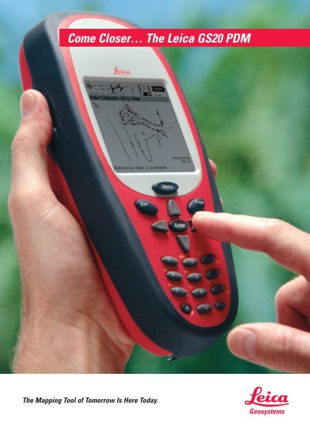
<strong>Come</strong> <strong>Closer…</strong> <strong>The</strong> <strong>Leica</strong> <strong>GS20</strong> <strong>PDM</strong><br />
<strong>The</strong> Mapping Tool of Tomorrow Is Here Today.
Feel <strong>The</strong> Power…<br />
<strong>The</strong> <strong>GS20</strong> Professional Data Mapper (<strong>PDM</strong>) from <strong>Leica</strong> Geosystems is the most advanced handheld <strong>GPS</strong><br />
for GIS and mapping.<br />
Powerful Features<br />
Powerful Functionality<br />
And A Powerful Promise<br />
An Abbreviated Innovation Timeline<br />
1914<br />
Leitz Camera<br />
invents the<br />
world’s first<br />
35mm camera.<br />
Leitz Camera<br />
soon becomes<br />
<strong>Leica</strong>.<br />
1921<br />
<strong>Leica</strong> teams<br />
with Wild<br />
Instruments,<br />
makers of the<br />
first theodelite,<br />
to begin its<br />
world renown<br />
surveying<br />
business.<br />
Now there’s an even better way to collect and maintain data in the field. <strong>Leica</strong>’s<br />
<strong>GS20</strong> <strong>PDM</strong> puts an entire <strong>GPS</strong> data collection system in the palm of your hand.<br />
For field personnel, this rugged and highly portable device offers all the features<br />
needed to collect on-the-spot GIS data anywhere, anytime, accurately:<br />
Powerful <strong>GPS</strong> technology offering unmatched accuracy<br />
User-friendly interface and ergonomic design<br />
Cable-free operation with Bluetooth wireless technology<br />
D<strong>GPS</strong> and High Precision upgradability<br />
<strong>The</strong> <strong>GS20</strong> <strong>PDM</strong> combines the all-in-one simplicity of a recreational <strong>GPS</strong> handheld<br />
with the power and flexibility of a professional grade mapping system.<br />
Providing you with a true turn-key <strong>GPS</strong> mapping solution, the <strong>GS20</strong> <strong>PDM</strong> is a <strong>GPS</strong><br />
receiver, antenna, and data collector, all in an ergonomic handheld.<br />
With the <strong>GS20</strong> <strong>PDM</strong>, powerful functionality doesn’t mean difficult to use. <strong>The</strong> menudriven<br />
interface and graphical map display make it easy to learn so field crews can<br />
start collecting data right away.<br />
Add to this the wireless connectivity to PCs and accessories provided by Bluetooth<br />
technology, and you begin to understand what we mean when we say the <strong>GS20</strong> <strong>PDM</strong><br />
is the mapping tool of tomorrow.<br />
You know you are getting an industry-leading technology solution because the <strong>GS20</strong><br />
<strong>PDM</strong> comes from <strong>Leica</strong> Geosystems. Known throughout the world for precision and<br />
accuracy, the people at <strong>Leica</strong> Geosystems have been delivering on the promise of<br />
technology excellence for more than a century.<br />
1968<br />
<strong>Leica</strong> introduces<br />
the first commercial<br />
satellite<br />
navigator, the<br />
MX702 CA.<br />
1991<br />
<strong>Leica</strong> develops<br />
the first commercial<br />
D<strong>GPS</strong><br />
systems using<br />
marine radio<br />
beacons to<br />
transmit error<br />
corrections.<br />
1992<br />
<strong>Leica</strong> System<br />
200 is used for<br />
the first <strong>GPS</strong><br />
survey of Mt.<br />
Everest (height<br />
8846.10 meters).<br />
1996<br />
<strong>Leica</strong> designs<br />
the first high<br />
precision realtime<br />
reference<br />
station network<br />
for the Øresund<br />
project.<br />
1999<br />
<strong>Leica</strong><br />
Geosystems<br />
introduces<br />
System 500<br />
becoming the<br />
first company<br />
to offer survey<br />
quality <strong>GPS</strong><br />
for collecting<br />
GIS data.<br />
2002<br />
<strong>Leica</strong><br />
Geosystems<br />
develops the<br />
<strong>GS20</strong> <strong>PDM</strong>,<br />
the first wireless<br />
sub-meter D<strong>GPS</strong><br />
handheld.
Enjoy <strong>The</strong> Freedom…<br />
GIS Data Collection Just Got Easier<br />
Intuitive menus speed<br />
data collection<br />
Edit feature geometry while on<br />
site with data management tools<br />
Find field assets easily with the<br />
<strong>GS20</strong> <strong>PDM</strong>’s navigation functions<br />
<strong>The</strong> <strong>GS20</strong> <strong>PDM</strong> handheld <strong>GPS</strong> mapping device features an intuitive interface with<br />
a familiar look and feel. Driven by intelligent context menus, the interface also<br />
provides easy-to-read graphical map displays and even allows for multi-tasking<br />
using innovative PowerPage functionality.<br />
Quality Monitor<br />
Use the Coordinate Quality Monitor to<br />
measure <strong>GPS</strong> precision in the field and<br />
ensure data quality before you get back<br />
to the office.<br />
Geo Clipboard<br />
<strong>The</strong> Geo Clipboard makes it possible<br />
to easily copy, cut and paste features<br />
and nodes, allowing separate features<br />
to share common nodes and multiple<br />
offsets from a single location.<br />
Screen<br />
High-resolution high-contrast screen<br />
ensures outdoor readability under<br />
any conditions.<br />
PowerPage<br />
Streamline fieldwork using the<br />
PowerPage functionality to switch<br />
instantly between user-selected<br />
applications and menus.
Do It All…<br />
Create Your Own Flexible System<br />
Use Your <strong>GS20</strong> <strong>PDM</strong> With<strong>The</strong> “WoRCS”<br />
Don’t let the small size fool you. <strong>The</strong> <strong>GS20</strong> <strong>PDM</strong> represents a technologically advanced<br />
<strong>GPS</strong> platform for GIS and mapping. Depending on your needs and applications,<br />
you can expand your functionality anytime by simply connecting the <strong>GS20</strong> <strong>PDM</strong><br />
to a variety of external devices via Bluetooth or serial interface.<br />
With your <strong>GS20</strong> <strong>PDM</strong> in hand, consider adding the WoRCS, Wireless Real-time<br />
Corrections System, for the ultimate in productivity.<br />
A belt-mounted communication hub, “smart” power supply and differential beacon<br />
radio, the WoRCS gives you everything you need for D<strong>GPS</strong> data collection.<br />
With built-in Bluetooth communications technology, you’ll have the ability to<br />
make wireless connections to other external devices such as cellular phones,<br />
Laser Rangefinders and PDAs.<br />
<strong>The</strong> WoRCS belt and accessory items are made of lightweight and comfortable<br />
materials with the quality and durability that have been the standard for law<br />
enforcement and military special forces.<br />
<strong>The</strong> WoRCS includes:<br />
Beacon receiver (satellite correction module or custom RTCM solutions also available)<br />
Bluetooth communication hub<br />
“Smart” power supply<br />
Increase Your Capabilities With A High Precision Upgrade<br />
Do you require the utmost in precision? Do you need to collect data in harsh<br />
<strong>GPS</strong> environments like dense foliage or urban canyons? Do you need centimeter<br />
level post-processing? <strong>The</strong> High Precision external package provides demanding<br />
users a premium grade external antenna for increased reception and greater<br />
multi-path rejection.<br />
<strong>The</strong> High Precision kit includes:<br />
<strong>Leica</strong> AT501: Survey grade L1 C/A code and phase antenna<br />
<strong>Leica</strong> Antenna Sash: Backpack free, light weight, breathable<br />
antenna mount<br />
<strong>Leica</strong> Telescopic Rod: Three sectioned, twist tightened, sash<br />
mounted antenna pole
<strong>The</strong> <strong>Leica</strong> <strong>GS20</strong> <strong>PDM</strong>…<br />
Unparalleled Accuracy From A <strong>GPS</strong> Handheld<br />
+15m<br />
Unexpectedly Simple To Use<br />
0<br />
-15m<br />
<strong>Leica</strong> Geosystems’ revolutionary <strong>GS20</strong> <strong>PDM</strong> is the first and only <strong>GPS</strong> handheld using<br />
proven correction technologies to provide sub-meter accuracy. Using either real-time<br />
corrections or post-processing, the <strong>GS20</strong> <strong>PDM</strong> makes it possible to collect sub-meter<br />
data without a backpack.<br />
Recreational <strong>GPS</strong><br />
+15m<br />
0<br />
-15m<br />
Competitive<br />
handheld devices<br />
Effortless data collection and asset management. <strong>The</strong> <strong>GS20</strong> <strong>PDM</strong> puts it all in the<br />
palm of your hand. No complicated set-up, no special training; the <strong>GS20</strong> <strong>PDM</strong> is<br />
a true out-of-the-box <strong>GPS</strong> solution. Just add sky!<br />
Wireless<br />
Built-in Bluetooth links with D<strong>GPS</strong> sources<br />
and external devices. In the office, use the<br />
USB Bluetooth module to download to<br />
your PC.<br />
Superior <strong>GPS</strong><br />
<strong>Leica</strong> Geosystems’ advanced <strong>GPS</strong> technology<br />
offers unmatched <strong>GPS</strong> reception in a<br />
handheld device.<br />
All-in-one<br />
All-in-one handheld design for professional<br />
data collection with zero setup.<br />
Keypad<br />
+15m<br />
0<br />
-15m<br />
<strong>Leica</strong> <strong>GS20</strong> <strong>PDM</strong><br />
Cell phone style keypad for easy data entry.
Specifications <strong>GS20</strong> <strong>PDM</strong><br />
Size 21.5cm L x 9cm W x 5cm D: 8.46" x 3.54" x 1.97"<br />
Weight (With Battery) 0.652kg or 1lb 7oz<br />
Power 2.1 Watt (typical) at 20°C, 7.2V internal, 12V external<br />
Receiver 12 channel parallel automatic selection. L1 Code / Phase<br />
Antenna Internal: <strong>Leica</strong> AT575 microstrip, built-in groundplane<br />
External: <strong>Leica</strong> AT501 microstrip, built-in groundplane (optional)<br />
Casing Sealed polycarbonite housing; protection against wind driven rain and dust. Sealed battery compartment and sealed<br />
compact flash. IP3 Rating<br />
Processor 120MHz Hitachi SH4 RISC floating point processor<br />
Display 240 x 240 pixel graphical LCD, 16 grayscale with backlight<br />
Internal Radio Bluetooth<br />
Keypad Front: Metal dome with high tactile feedback, protected on/off<br />
Side: Duplicate up, down and enter keys<br />
Memory ATA compact flash: Standard 32MB; Max 2GB<br />
Data Transfer Triple redundancy: Bluetooth cable-free transfer, RS232 lemo, ATA compact flash<br />
Internal Ports RS232 Serial: 7 pin Lemo; Antenna Coaxial Lemo<br />
Operating Temperature -20°C to 55°C / -4°F to 122°F<br />
Storage Temperature -40°C to 75°C / -40°F to 167°F<br />
Humidity 99% non-condensing<br />
Shock 1.2m drop<br />
Baseline rms (Post-processing)* L1 Code only: Typically 30cm (rms)<br />
L1 Code and Phase typically 5 to 10mm + 2ppm (rms)<br />
D<strong>GPS</strong>/RTCM RTCM version 2.1 (9,2 & 1,2)<br />
Standard support for Coast Guard Beacon and RACAL Satellite differential<br />
Baseline rms (D<strong>GPS</strong>/RTCM)* L1 Code only: Typically 40cm (rms)<br />
Data Recording Rate and Capacity At 1Hz measurement; 1 hour runtime = 2MB, 16 hours continuous measurement per 32MB standard compact flash<br />
Desktop Software GIS DataPRO version 2.1; Native shapefile format, L1 code / phase post-processing, ASCII export, import and export to dwg,<br />
dxf, dgn and mif<br />
Application Data Collection, Data Management, Navigation, File Browser<br />
Battery Lithium-Ion 7.2 Volt 2100mAH w/ Dallas microprocessor<br />
Charger Dual-bay sequential fast charger<br />
*Baseline rms refers to accuracy in position. Accuracy in height is 2x accuracy in position. Figures are for normal to<br />
favorable conditions.<br />
Standard Configurations<br />
<strong>GS20</strong> <strong>PDM</strong> Stand-Alone<br />
<strong>GS20</strong> <strong>PDM</strong> WoRCS and<br />
High Precision<br />
Dealer’s Stamp<br />
Each <strong>GS20</strong> <strong>PDM</strong> is packaged in it’s industrial-strength storage and travel case, and delivered assembled and<br />
ready for use.<br />
<strong>GS20</strong> <strong>PDM</strong> Stand-Alone<br />
1 Small storage and travel case<br />
1 <strong>GS20</strong> <strong>PDM</strong> handheld <strong>GPS</strong> receiver<br />
1 <strong>GS20</strong> <strong>PDM</strong> holster case<br />
2 Li-Ion batteries, 7.2V (1 spare)<br />
1 Dual-bay battery charger<br />
1 PC USB Bluetooth module<br />
1 Data transfer cable, <strong>GS20</strong> <strong>PDM</strong> to RS232<br />
1 GIS DataPRO software CD<br />
1 Set of documentation<br />
WoRCS<br />
When bundling the <strong>GS20</strong> <strong>PDM</strong> with the WoRCS,* add the following:<br />
1 Large storage and travel case (replaces small case)<br />
1 WoRCS belt<br />
1 WoRCS power supply module and jacket<br />
1 WoRCS Bluetooth module and jacket<br />
1 WoRCS RTB module (Real-Time Beacon)* and jacket<br />
2 Li-Ion batteries, 7.2V (total of 4)<br />
*This parts list is for the WoRCS-RTB. Parts will differ somewhat for WoRCS-Satellite and other WoRCS configurations.<br />
See your <strong>Leica</strong> Geosystems Dealer for details.<br />
High Precision<br />
When bundling the <strong>GS20</strong> <strong>PDM</strong> with the High Precision package add the following:<br />
1 Large storage and travel case (replaces small case)<br />
1 AT501 high precision <strong>GPS</strong> antenna<br />
1 Telescopic rod with 5/8" adapter<br />
1 WoRCS belt (1 belt in total when bundled with the WoRCS)<br />
1 Backpack-free antenna sash<br />
1 Antenna cable, <strong>GS20</strong> <strong>PDM</strong> to external antenna<br />
<strong>The</strong> <strong>GS20</strong> <strong>PDM</strong> may be purchased with both WoRCS and High Precision Bundles.<br />
Illustrations, descriptions and technical data are not binding and may be changed.<br />
Printed in Switzerland. Copyright <strong>Leica</strong> Geosystems AG, Heerbrugg, Switzerland, 2002.<br />
733456en – X.02 – RDV<br />
<strong>Leica</strong> Geosystems AG<br />
CH-9435 Heerbrugg<br />
(Switzerland)<br />
Phone +41 71 727 31 31<br />
Fax +41 71 727 46 73<br />
www.leica-geosystems.com