Fact sheet Sonnega Weststellingwerf
Fact sheet Sonnega Weststellingwerf
Fact sheet Sonnega Weststellingwerf

Create successful ePaper yourself
Turn your PDF publications into a flip-book with our unique Google optimized e-Paper software.
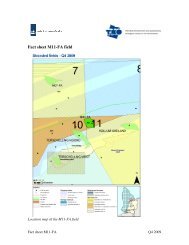
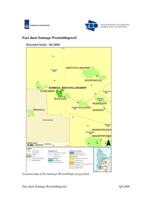
<strong>Fact</strong> <strong>sheet</strong> <strong>Sonnega</strong> <strong>Weststellingwerf</strong>Location map of the <strong>Sonnega</strong> <strong>Weststellingwerf</strong> gas field<strong>Fact</strong> <strong>sheet</strong> <strong>Sonnega</strong> <strong>Weststellingwerf</strong> Q4 2009
General informationThe <strong>Sonnega</strong> <strong>Weststellingwerf</strong> gas field was discovered in 1963 by NAM by well<strong>Sonnega</strong>-weststellingwerf-01. It is currently situated within two concessions ofVermillion: Gorredijk (north) and Steenwijk (south). The field is located on the FrieslandPlatform.Gas is contained in the Upper Rotliegend Group (RO); a secondary target is the Zechsteingroup (ZE).Regional information on the sedimentology and the structural configuration of the area isavailable in map <strong>sheet</strong> V: Sneek-Zwolle.Sequence of eventsDateEvent25-02-1963 Spud date <strong>Sonnega</strong>-weststellingwerf-0119-02-1963 TD reached 1982.5.0 m ah03-05-1963 to 28-07-1963 Production tests 1810,5 - 1880 m ah (RO & ZE)29-07-1989 Elf Petroland production license Gorredijk05-09-1994 NAM Production license Steenwijk19-06-1998 Transfer license Steenwijk to Elf Petroland19-05-2004 Transfer license Gorredijk to Vermilion19-05-2004 Transfer license Steenwijk to VermilionPlug dataDepthmPorosity%Hor. PermeabilitymDVer. PermeabilitymDDensityg/cm 31800.1 0.2 2.951810 3.5 0.5 2.751812 28 76 2.811815 16 10 2.811875.4 27 960 2.641875.7 27 1170 813 2.631877 28 1520 2.641877.6 26 510 2.641877.9 26 594 378 2.641879.2 26 1130 2.641882.1 28 1617 2.631882.4 29 2100 2.631883 22 220 30 2.651883.4 27 1050 2.631885.6 23 193 213 2.651887.5 25 420 203 2.661889.3 24 1910 2.661891.1 21 164 98 2.671893.8 26 487 389 2.661896.3 25 467 430 2.651901.2 25 796 500 2.651902.8 26 714 2.65More detailed information of this interval is available<strong>Fact</strong> <strong>sheet</strong> <strong>Sonnega</strong> <strong>Weststellingwerf</strong> Q4 2009
Hydrocarbon specificationsReservoir CH 4 % CO 2 % N 2 % H 2S % GHV MJ/m 3Upper Rotliegend Group (RO) 86.2 0.6 8.4 - 35.17Well statusWell SOW-01 is plugged and abandoned.InfrastructureThe gas field is located between the producing fields Oldelamer (west) and Blesdijke(east). Both fields are produced by Vermilion. The nearest production facility is locatedapproximately sixteen kilometers to the southeast.Public ReferencesRGD 1995. Geological Atlas of the Deep subsurface of the Netherlands. Map <strong>sheet</strong> V:Sneek-Zwolle. Haarlem.RGD & NOGEPA 1993, Stratigraphic nomenclature of the Netherlands, MededelingenRijks Geologische Dienst, Nr. 50SodM 1963, Proces-Verbaal nr. 4638. (Official Report of the State Supervision of theMines on the proven occurrence of gas/oil in a well)Vermilion 1963: Composite well log, <strong>Sonnega</strong> Weststellingswerf-01. On open fileFor more information stranded Oil&Gas fields in the Netherlands:http://www.nlog.nl/nl/reserves/reserves/stranded.htmlFor released Well data and Seismic data contact DINOloket:http://www.dinoloket.nlFor geological maps of the deep subsurface of the Netherlands:http://www.nlog.nl/nl/pubs/maps/geologic_maps/NCP1.htmlLiability<strong>Fact</strong>s and figures supplied on this fact <strong>sheet</strong> have been compiled carefully. Great care has been taken toensure correct coverage of all information. TNO and the Ministry of Economic Affairs do not accept anyliability for any direct or indirect damage of any kind ensuing from the use of information published on this<strong>sheet</strong>.<strong>Fact</strong> <strong>sheet</strong> <strong>Sonnega</strong> <strong>Weststellingwerf</strong> Q4 2009