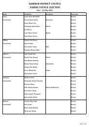
Little Waldingfield 2007 - Babergh District Council
Little Waldingfield 2007 - Babergh District Council
Little Waldingfield 2007 - Babergh District Council

You also want an ePaper? Increase the reach of your titles
YUMPU automatically turns print PDFs into web optimized ePapers that Google loves.
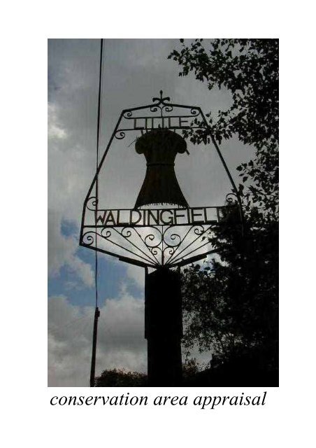
conservation area appraisal
© Crown Copyright <strong>Babergh</strong> <strong>District</strong> <strong>Council</strong> license no 100023274 <strong>2007</strong>
IntroductionThe conservation area in <strong>Little</strong><strong>Waldingfield</strong> was originally designatedby West Suffolk County <strong>Council</strong> in 1973,and inherited by <strong>Babergh</strong> <strong>District</strong><strong>Council</strong> at its inception in 1974.The <strong>Council</strong> has a duty to review itsconservation area designations from timeto time, and this appraisal examines<strong>Little</strong> <strong>Waldingfield</strong> under a number ofdifferent headings as set out in EnglishHeritage’s new ‘Guidance onConservation Area Appraisals’ (2006).As such it is a straightforward appraisalof <strong>Little</strong> <strong>Waldingfield</strong>’s built environmentin conservation terms and is essentiallyan update on a draft document producedback in 1997, when the village wasconsidered for a rural grant scheme thatnever came to fruition.As a document it is neither prescriptivenor overly descriptive, but more ademonstration of ‘quality of place’,sufficient for the briefing of the PlanningOfficer when assessing proposed worksin the area. The photographs and mapsare thus intended to contribute as muchas the text itself.As the English Heritage guidelines pointout, the appraisal is to be read as ageneral overview, rather than as acomprehensive listing, and the omissionof any particular building, feature orspace does not imply that it is of nointerest in conservation terms.Text, photographs and map overlays byPatrick Taylor, Conservation Architect,<strong>Babergh</strong> <strong>District</strong> <strong>Council</strong> <strong>2007</strong>.
© Crown Copyright <strong>Babergh</strong> <strong>District</strong> <strong>Council</strong> license no 100023274 <strong>2007</strong>
Topographical FrameworkThe village of <strong>Little</strong> <strong>Waldingfield</strong> liesabout four miles north-east of the markettown of Sudbury in south-west Suffolk,and a similar distance south of thehistoric village of Lavenham.It is situated on a spur of higher landbetween 60 and 70 m above O.D.,stretching south-westwards between twotributaries at the head of the river Box,itself a tributary of the Stour.The village runs north-eastwards forabout half a mile along the B 1115 fromSudbury, an equal distance either side ofa T-junction where a minor road meets itfrom the south-east.Whilst the surrounding countryside isessentially covered with the usualoverlying layer of boulder clay of ‘High’Suffolk’s claylands, the village sits withina pocket where this is absent, exposingthe underlying glacial sands and gravels.Other such pockets occur nearby to thesouth-west of the village near Great<strong>Waldingfield</strong>, where the tributaries of theBox meet before flowing off to the southeast,as well as to the north-west of thevillage where one of those tributaries hasremoved the clay and replaced it withalluvium.
© Crown Copyright <strong>Babergh</strong> <strong>District</strong> <strong>Council</strong> license no 100023274 <strong>2007</strong>
Archaeological Significance<strong>Little</strong> <strong>Waldingfield</strong> is of no great knownsignificance in archaeological terms.The County Sites and Monuments Recordlists only two sites within the villageproper, one of which is the Church of StLawrence.At the other, ‘The Priory’, the remains ofbrick vaults in the cellar had beenattributed to a Benedictine Priory, butnow this is thought to be more likely a14 th Century Manor house.Nearby in Great <strong>Waldingfield</strong> is to befound <strong>Babergh</strong> Hall, the ancient meetingplace for the Hundred of <strong>Babergh</strong>, fromwhich the modern <strong>District</strong> <strong>Council</strong> takesits name.The Domesday survey of 1086 lists twomanors and one church for <strong>Waldingfield</strong>as a whole, but makes no distinctionbetween <strong>Little</strong> or Great.The name of the village is reputed tomean the ‘open area (field) of thedwellers by the wold (wood)’.
© Crown Copyright <strong>Babergh</strong> <strong>District</strong> <strong>Council</strong> license no 100023274 <strong>2007</strong>
Intrinsic Quality of Buildings<strong>Little</strong> <strong>Waldingfield</strong> has its fair share oflisted buildings, although only theChurch of St Lawrence is listed grade I,the rest being grade II.The Church is mainly 15 th Century (‘allPerp’ according to Pevsner) of flint andstone, but unfortunately cemented overon the nave, aisles and chancel.This together with ‘Churchside’, theformer almshouses adjoining, and thePriory over the road form an importantgroup of historic buildings.Two very different, but striking, largerfarmhouses are to be found towards thenorth end of the village, although neitheris listed better than grade II.Wood Hall has a grand three storeywhite brick and slate roofed 19 th Centuryfronting to an older timber-framedbuilding, whilst Malting Farm has adecoratively rendered gabled front,again 19 th Century on an older timberframedbuilding, with a circular brickbuilt malt kiln attached at one end.The remaining grade II listed buildingsare for the most part domestic, variouslytimber-framed or brick built, but alsoinclude a K6 telephone kiosk on TheStreet.
© Crown Copyright <strong>Babergh</strong> <strong>District</strong> <strong>Council</strong> license no 100023274 <strong>2007</strong>
Traditional Building Materials<strong>Little</strong> <strong>Waldingfield</strong> has examples of mostof Suffolk’s local building materials thathave been used through the ages.Timber-framed construction is there butnot in an immediately obvious way, asthere are no jettied first floors or exposedtimbers. Brick or rendered fronts havehidden most of the clues and steepplaintiled roofs are all that remainvisible.Two rendered examples of timber-framedhouses at the north end of the villagelook more authentically ancient withtheir thatched roofs and large brickchimneys.Black weather-boarded barns, some nowconverted to dwellings, some still inagricultural use, are roofed in pantiles.Soft ‘Suffolk red’ bricks appear aschimneys on many buildings, whilst nearthe village centre there is aconcentration of 19 th Century brickcottages with slate roofs, many withpleasing polychrome brick patterning inthe local red and ‘Suffolk white’ bricks,the latter probably from nearby Sudbury.
© Crown Copyright <strong>Babergh</strong> <strong>District</strong> <strong>Council</strong> license no 100023274 <strong>2007</strong>
Hierarchy of SpacesWith its concentration of red and whitebrick cottages and a very wide pavement,the area of The Street adjoining the T-junction has a definite feel of havingbeen at one time more of a centre to thevillage. The adjoining Swan publichouse set well back from the road adds tothis wider public space and representsthe only remaining commercial frontagethere.Other subtle clues to this being the centreof the village include the listed K6telephone box, the adjoining post boxand the presence of pavements on bothsides of the road.Away from this ‘centre’ the village getsmarkedly more rural. Church Roadgently leads away south-eastwards, thearea comprising the Church, formeralmshouses and the Priory oppositeproviding an important focal group ofolder buildings, whilst beyond thebuildings get less dense and grass vergestake over, before we get amongst fields.On the road to the north-east, once pastthe ‘centre’, development is restricted tothe western side only, giving good viewsout over open countryside to the east.
© Crown Copyright <strong>Babergh</strong> <strong>District</strong> <strong>Council</strong> license no 100023274 <strong>2007</strong>
Trees & PlantingAbout a mile up the road to the northeastof <strong>Little</strong> <strong>Waldingfield</strong> lies CampsWood, an ancient woodland remnant ofabout fifty acres.Ancient woodland practices, however,can still be observed in the village itselfin the form of various pollarded trees.Two particularly good multi-stemmedAsh pollards can be found on thenorthern part of The Street where fieldsadjoin the road.Nearer the centre of the village on thewestern side of the same road there is amagnificent old Oak, whilst at theappropriately named Walnut Cottagethere is a fine specimen of this tree withfour main stems.Most of the trees within the village arethe subject of a single tree preservationorder (TPO 230). This covers thevarious strips, groups or just singlespecimens that occur for the most part offChurch Road and along the northernpart of The Street. Around the roadjunction the central area is noticeablymore built up and devoid of trees.To the north of the Church there are anumber of old Lime trees, the lastremnants of an avenue that went fromthere across the field to Wood Hall. Afootpath still defines this route, whichmight prove a suitable case for thereinstatement of the missing trees.
© Crown Copyright <strong>Babergh</strong> <strong>District</strong> <strong>Council</strong> license no 100023274 <strong>2007</strong>
Relationship to Open CountrysideFor the most part, <strong>Little</strong> <strong>Waldingfield</strong>’sdevelopment has only been one plot deepalong the legs of the T-junction of roadsthat meet there.One exception to this is on the easternside of the road north-eastwards towardsMonks Eleigh, where fields abut the roadfor some distance, affording good viewsout between the trees into the countrysidebeyond.The presence of working farms within thevillage amplifies the rural character tobe found there. The village has severalfootpath links radiating out into thesurrounding countryside, many of theselinking into neighbouring Great<strong>Waldingfield</strong>’s footpath network.Two ‘internal’ footpaths occur, one tothe south behind the houses of TheStreet’s south-westerly extension, theother previously mentioned linking theChurch across the fields to Wood Hall.At the northern end of the latter a smallgrass area could be created, acting as aterminus to the path and creating asetting for Wood Hall. A similar grassarea can be found a few yards furthernorth opposite Maltings Farm.It is recommended that the conservationarea be slightly extended here to includeFootpath 5 and the thin triangle of landin between. Any future reinstatement ofthe avenue of trees will thus be protected.
© Crown Copyright <strong>Babergh</strong> <strong>District</strong> <strong>Council</strong> license no 100023274 <strong>2007</strong>
Prevailing & Former UsageFrom the 15 th to 17 th Centuries <strong>Little</strong><strong>Waldingfield</strong> played a small part inSuffolk’s then thriving woollen clothindustry as an outpost to the nearbyimportant centre of Lavenham.The local economy was primarilyagricultural, but did exploit the land inother ways too, as witnessed by the Tithemap’s reference to fields named aftersuch ventures as Hop Grounds, GravelPits, Brick Kiln or Mill Field.A post type windmill at one time stoodsouth-west of the main village near HoleFarm and there was a smithy in ChurchRoad.With no immediately adjacent watercourse, the village relied to a greatextent on wells and ponds for its watersupply. A number of ponds still remainin the north to the rear of Malting Farm.Here also the red brick maltings andcircular malt kiln remain, although muchof this farm, including several blackweather-boarded barns, has now beenconverted for residential use.Similar black barns, still in their originalagricultural use, do however remain atPriory Farm in Church Road.
© Crown Copyright <strong>Babergh</strong> <strong>District</strong> <strong>Council</strong> license no 100023274 <strong>2007</strong>
Losses & Possible Gains<strong>Little</strong> <strong>Waldingfield</strong> has suffered no majornegative effects, but rather more of agentle erosion at the edges.The housing estate off The Street south ofWood Hall interrupts the rural roadpattern with its grass-verged widevisibility splay. This could be improvedif it became part of a greater green thatcould be created for village amenity outof the field opposite. The suggestedreinstatement of the avenue of Lime treesbetween Wood Hall and the Churchwould form the boundary to such a greenspace, but would close off some existingcountryside vistas.Some newer bungalows and chalet styledwellings along both Church Road andThe Street are rather out of place, butare mostly well set back and screened.Nearer the centre of the village a doublegarage extension to one of the brickcottages attempts to blend in usingmatching materials, whilst a number ofother properties suffer the indignity ofreplacement windows, but fortunatelyfew so far are in uPVC.There is scope for undergrounding someof the overhead wiring in the village,particularly near the Church. Shouldthis be done there is the opportunity toupgrade the paving finishes. A softerapproach than the current blacktop andconcrete kerbing could be achieved usinga chipping based surface dressing tofootways and exposed aggregate kerbs.A more formal type of paving could beused in the wider space of the centralarea, perhaps taking in the forecourt ofthe Swan.
References & Further ReadingChatwin, C P 1961 East Anglia and Adjoining Areas British Regional GeologyHMSOClive, H 1979 Beyond Living Memory: The Story of a Suffolk VillageD.o.E. & D.o.N.H. 1994 Planning Policy Guidance: Planning & the HistoricEnvironment (PPG 15) HMSOD.o.E. 1978 List of Buildings of Special Architectural or Historical Interest: <strong>District</strong>of <strong>Babergh</strong>: Parishes of … <strong>Little</strong> <strong>Waldingfield</strong>…Domesday Book 1986 Suffolk PhillimoreDymond, D & Martin, E (eds.) 1988 An Historical Atlas of Suffolk Suffolk County<strong>Council</strong>English Heritage 1995 Conservation Area Practice HMSOEnglish Heritage 2006 Guidance on Conservation Area Appraisals HMSOFlint, B 1979 Suffolk Windmills BoydellGoult, W 1990 A Survey of Suffolk Parish History Suffolk County <strong>Council</strong>Pevsner, N 1976 The Buildings of England: Suffolk PenguinSuffolk County <strong>Council</strong> 1997 Sites and Monuments RecordTaylor, P 2005 Living in a Conservation Area <strong>Babergh</strong> <strong>District</strong> <strong>Council</strong>Tithe Map & Apportionment 1839 <strong>Little</strong> <strong>Waldingfield</strong> Suffolk Records OfficeAll maps in this document are based upon the Ordnance Survey’s maps with thepermission of Her Majesty’s Stationery Office© Crown CopyrightUnauthorised reproduction infringes Crown Copyright and may lead to prosecutionor civil proceedings. <strong>Babergh</strong> <strong>District</strong> <strong>Council</strong> license no 100023274 <strong>2007</strong>Proposed extension to ConservationArea designated and this Appraisaladopted as Supplementary PlanningGuidance by <strong>Babergh</strong> <strong>District</strong> <strong>Council</strong>Strategy Committee 15 November <strong>2007</strong>