

Cwm Prysor (Merionethshire) - Royal Commission on the Ancient ...
Cwm Prysor (Merionethshire) - Royal Commission on the Ancient ...
Cwm Prysor (Merionethshire) - Royal Commission on the Ancient ...

You also want an ePaper? Increase the reach of your titles
YUMPU automatically turns print PDFs into web optimized ePapers that Google loves.
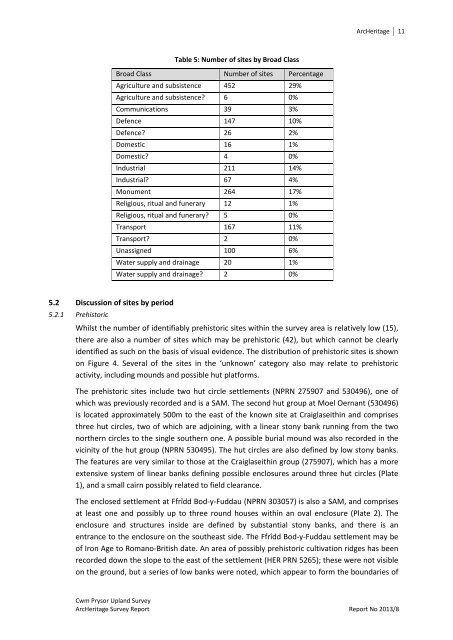
ArcHeritage 11Table 5: Number of sites by Broad ClassBroad Class Number of sites PercentageAgriculture and subsistence 452 29%Agriculture and subsistence? 6 0%Communicati<strong>on</strong>s 39 3%Defence 147 10%Defence? 26 2%Domestic 16 1%Domestic? 4 0%Industrial 211 14%Industrial? 67 4%M<strong>on</strong>ument 264 17%Religious, ritual and funerary 12 1%Religious, ritual and funerary? 5 0%Transport 167 11%Transport? 2 0%Unassigned 100 6%Water supply and drainage 20 1%Water supply and drainage? 2 0%5.2 Discussi<strong>on</strong> of sites by period5.2.1 PrehistoricWhilst <strong>the</strong> number of identifiably prehistoric sites within <strong>the</strong> survey area is relatively low (15),<strong>the</strong>re are also a number of sites which may be prehistoric (42), but which cannot be clearlyidentified as such <strong>on</strong> <strong>the</strong> basis of visual evidence. The distributi<strong>on</strong> of prehistoric sites is shown<strong>on</strong> Figure 4. Several of <strong>the</strong> sites in <strong>the</strong> ‘unknown’ category also may relate to prehistoricactivity, including mounds and possible hut platforms.The prehistoric sites include two hut circle settlements (NPRN 275907 and 530496), <strong>on</strong>e ofwhich was previously recorded and is a SAM. The sec<strong>on</strong>d hut group at Moel Oernant (530496)is located approximately 500m to <strong>the</strong> east of <strong>the</strong> known site at Craiglaseithin and comprisesthree hut circles, two of which are adjoining, with a linear st<strong>on</strong>y bank running from <strong>the</strong> tw<strong>on</strong>or<strong>the</strong>rn circles to <strong>the</strong> single sou<strong>the</strong>rn <strong>on</strong>e. A possible burial mound was also recorded in <strong>the</strong>vicinity of <strong>the</strong> hut group (NPRN 530495). The hut circles are also defined by low st<strong>on</strong>y banks.The features are very similar to those at <strong>the</strong> Craiglaseithin group (275907), which has a moreextensive system of linear banks defining possible enclosures around three hut circles (Plate1), and a small cairn possibly related to field clearance.The enclosed settlement at Ffrîdd Bod-y-Fuddau (NPRN 303057) is also a SAM, and comprisesat least <strong>on</strong>e and possibly up to three round houses within an oval enclosure (Plate 2). Theenclosure and structures inside are defined by substantial st<strong>on</strong>y banks, and <strong>the</strong>re is anentrance to <strong>the</strong> enclosure <strong>on</strong> <strong>the</strong> sou<strong>the</strong>ast side. The Ffrîdd Bod-y-Fuddau settlement may beof Ir<strong>on</strong> Age to Romano-British date. An area of possibly prehistoric cultivati<strong>on</strong> ridges has beenrecorded down <strong>the</strong> slope to <strong>the</strong> east of <strong>the</strong> settlement (HER PRN 5265); <strong>the</strong>se were not visible<strong>on</strong> <strong>the</strong> ground, but a series of low banks were noted, which appear to form <strong>the</strong> boundaries of<str<strong>on</strong>g>Cwm</str<strong>on</strong>g> <str<strong>on</strong>g>Prysor</str<strong>on</strong>g> Upland SurveyArcHeritage Survey Report Report No 2013/8


![The Source of the Usk Walk [2012 PDF]](https://img.yumpu.com/49285699/1/190x245/the-source-of-the-usk-walk-2012-pdf.jpg?quality=85)


