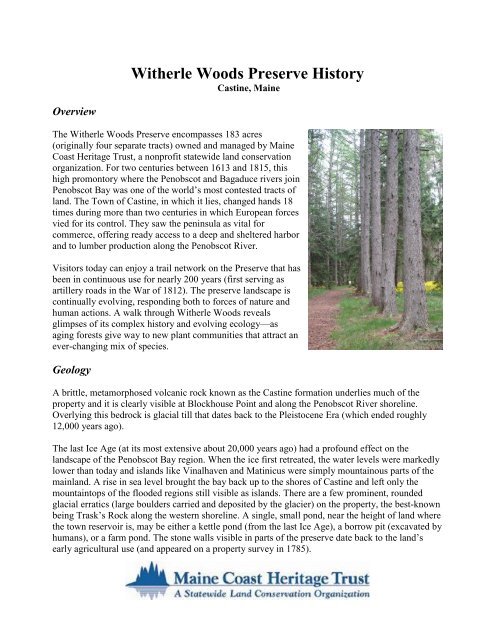
Witherle Woods: - Maine Coast Heritage Trust
Witherle Woods: - Maine Coast Heritage Trust
Witherle Woods: - Maine Coast Heritage Trust

You also want an ePaper? Increase the reach of your titles
YUMPU automatically turns print PDFs into web optimized ePapers that Google loves.
Penobscot River. There were also two semi-circular earthwork batteries along the steep bluff oneither side of Blockhouse Point, confirmed by an archaeological survey done in 2001-2003 by Dr.Alaric Faulkner. Some of the depressions in the land still visible today may trace back toindentations from cannon fire or “fox holes” dug during the Revolutionary War occupation.“In <strong>Witherle</strong> Park are to be found the remains of two small Revolutionarybatteries and the site of an old block-house... Only the ledge on which theblock-house stood can now be seen. This building was probablyconstructed more for an observatory than for the protection it wouldafford, though it was built in true block-house style. It was twenty-feetsquare on the ground floor, the second story projected over the first.”-- George Augustus WheelerCastine Past and Present (1896)Network of trails in the area that became <strong>Witherle</strong> Park visible on the western side of the peninsula1889 Map of Castine
Creating <strong>Witherle</strong> ParkAfter the War of 1812, the land saw less human drama, serving primarily as a wood lot and pastureland. By 1835, Castine had become one of the wealthiest villages in North America, having made afortune on the salt trade (and by some accounts smuggling as well). Castine subsequently became adestination for “rusticators,” affluent families from East <strong>Coast</strong> urban centers who came for longstays in summer homes and inns. For both rusticators and year-round residents, Castine residentGeorge H. <strong>Witherle</strong> (1831-1906) generously provided a setting where they could walk, drivecarriages and picnic—on land now part of the <strong>Witherle</strong> <strong>Woods</strong> Preserve.Mr. <strong>Witherle</strong>, the son of a prominent Castine merchant and ship owner, ran his father’s general storeand ship’s chandlery for a while and then sold out to his brother. An avid outdoorsman andAppalachian Mountain Club member, <strong>Witherle</strong> was among the first avid explorers of the KatahdinFrom the time <strong>Witherle</strong> constructed carriage paths in the 1870s, communitymembers enjoyed rides and walks through this scenic headland.© Baldwin Coolidge, circa 1890, Courtesy of Castine Historical Society
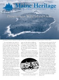
egion (in the early 1880s), climbing <strong>Maine</strong>’s highest mountain at least 9 times. The mountain has aravine that still bears his name.In the early 1870s, George <strong>Witherle</strong> bought land on the peninsula’s northwest side and laid out 4miles of carriage roads open to the community in what became known as <strong>Witherle</strong> Park. Hisvisionary model of community carriage roads was later adopted on Mount Desert Island andincorporated into Acadia National Park. Some of <strong>Witherle</strong>’s paths followed a road system createdfor British artillery during the War of 1812. While woods have grown up since the trails were firstestablished, the community has enjoyed use of these paths for more than 130 years.On the peninsula’s highest point (218feet above sea level), <strong>Witherle</strong>constructed an 80-foot observatory (laterconsumed in a 1903 fire that burnedroughly half his land, along with severalnearby summer homes and the Dome-ofthe-RockHotel at Dyce Head). <strong>Witherle</strong>bought the lands surrounding FortGeorge as well to ensure that the publicwould have continued access to thisimportant part of its history. An activeand generous community member,<strong>Witherle</strong> also bequeathed money forconstruction of Castine’s library.“One desiring a quiet stroll through fieldsand woods should go into <strong>Witherle</strong> Park…theprivate property of a public-spirited citizenwho allows free access to it at all times uponthe sole condition that the gate be kept closedand that no malicious or thoughtless mischiefbe done to the observatory or trees.”-- George Augustus WheelerCastine Past and Present (1896)Conserving <strong>Witherle</strong> <strong>Woods</strong> PreserveGeorge <strong>Witherle</strong>’s daughter Amy inherited the Park and willed it to her cousin Anna <strong>Witherle</strong> uponher death in 1949. Anna <strong>Witherle</strong> subsequently sold her uncle’s land to Francis W. Hatch, Jr.,confident that he and his wife Marjory would take good care of it. In memory of his parents, theirson Frank Hatch (a long-time board and council member of <strong>Maine</strong> <strong>Coast</strong> <strong>Heritage</strong> <strong>Trust</strong>) deeded96.5 acres of the <strong>Witherle</strong> <strong>Woods</strong> property to MCHT in 1985, with restrictions to ensure that theland would remain undeveloped and accessible for quiet recreation.A decade later, the Preserve expanded with the gift to MCHT of 36 adjoining acres made byKatharine Foote Howland, and Elizabeth, Virginia, and David Foote in memory of their lategrandparents Frederick D. Foote, Sr. and Elizabeth Taylor Foote, and in tribute to their parentsFrederick D. and Sara F. Foote. Their gift, managed similarly to the former Hatch lands, helpedensure permanent protection for much of the historic <strong>Witherle</strong> Park.When adjoining land to the northeast was listed in an estate sale in 2002, MCHT was able topurchase 19 acres but a second parcel near Dyce Head remained in private hands. The Town hadtried to purchase the second property, but a bond put before local voters failed by four votes.
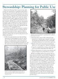
Fortunately, the conservation-minded buyer of that parcel opted to donate the 31-acre Dyce Headparcel to MCHT in 2006—expanding the total <strong>Witherle</strong> <strong>Woods</strong> Preserve to 183 acres.To ensure an adequate water supply, the Town of Castine took by eminent domain a third of an acrenear <strong>Witherle</strong> Hill, where it manages an underground reservoir for the municipal water supply.A Changing LandscapeWhile the steepest slopes of the property have remained wooded through the centuries, portionswere periodically cleared for pasture (for sheep and other livestock) as early as the 1700s. Thenumerous stone walls date back to this era. A major fire in 1903 burned roughly half the woods in“<strong>Witherle</strong> Park,” but over the last century the woods regenerated and overtook most of the pastureland.By 2000, many older conifer trees were succumbing to diseases like spruce bud worm, spruce barkbeetle, and balsam fir wooly adelgid. In response to extensive blow downs, MCHT began to cut andremove some of the deadwood. Then in the Patriot’s Day storm of 2007, high winds brought downmany additional trees. A microburst in a storm that September leveled about 50 acres of <strong>Witherle</strong><strong>Woods</strong> (primarily in the Dyce Head area and around the <strong>Witherle</strong> Hill summit). Following theseintense storms, <strong>Maine</strong> <strong>Coast</strong> <strong>Heritage</strong> <strong>Trust</strong> had remedial salvage and thinning work done on morethan half the preserve to reopen trails and to prevent downed timber from becoming a fire hazard.While these dramatic storms took down many historic trees nearing the century mark, they left amore diverse landscape. The forestry work created a patchwork of open areas with a great deal of“edge habitat” beneficial to many species. An ecological study updated in 2010 found 195 plantspecies (21 of which are invasive non-native species that must be closely monitored—such asJapanese barberry and Oriental bittersweet). Most areas are regenerating well, primarily with redand white spruce, fir, white pine and red oak. MCHT had a bird survey done in 2009, following thetimber salvage operations, to establish a baseline for measuring changes as the forest compositionevolves over time. The survey found 48 bird species, with abundant edge species such whitethroatedsparrow, northern parula, black-throated green warbler and winter wren.<strong>Maine</strong> <strong>Coast</strong> <strong>Heritage</strong> <strong>Trust</strong> owns and manages <strong>Witherle</strong> <strong>Woods</strong> as a public preserve where wildlifecan thrive and visitors can enjoy its natural beauty and fascinating history. The <strong>Trust</strong> continues toseek additional historical information on <strong>Witherle</strong> <strong>Woods</strong>, and welcomes contact from those whohave records or images of the property.
ReferencesBuker, George E. The Penobscot Expedition: Commander Saltonstall and the MassachusettsConspiracy of 1779. Annapolis: Naval Institute Press, 2002.Dibble, Alison. Natural Resource Inventory of the Hatch-Foote-Perkins Parcels of<strong>Witherle</strong> <strong>Woods</strong> Preserve, Castine, <strong>Maine</strong>. Brooklin, ME: Stewards, LLC, 2010.Faulkner, Alaric. <strong>Witherle</strong> <strong>Woods</strong> Archaeological Survey and Mapping Project: Interim Report.Orono, ME: University of <strong>Maine</strong>, 2002.<strong>Maine</strong> Geologic Survey, “Penobscot Bay: 10,000 Years Ago,”http://www.maine.gov/doc/nrimc/mgs/explore/marine/sites/may99.htmVan Horn, David. A Brief Early History of Castine: Prehistory to 1815. Castine, ME: Robert’sPress, 1993.Wheeler, George Augustus. Castine Past and Present: The Ancient Settlement of Pentagöet and theModern Town. Boston: Rockwell and Churchill Press, 1896.<strong>Maine</strong> <strong>Coast</strong> <strong>Heritage</strong> <strong>Trust</strong> acknowledges the contributions of historian Jim Stone and Paige Lilly,Curator of the Castine Historical Society, in preparing this historical overview.