

Chapter 3. Resuscitating Geomorphology with the ... - Michael Oard
Chapter 3. Resuscitating Geomorphology with the ... - Michael Oard
Chapter 3. Resuscitating Geomorphology with the ... - Michael Oard

Create successful ePaper yourself
Turn your PDF publications into a flip-book with our unique Google optimized e-Paper software.
<strong>Chapter</strong> 3<strong>Resuscitating</strong> <strong>Geomorphology</strong> <strong>with</strong> <strong>the</strong> Genesis FloodAlmost every scientist today would ei<strong>the</strong>r laugh or scoff at <strong>the</strong> idea of inserting <strong>the</strong>Genesis Flood into a modern scientific discipline. For over two centuries, <strong>the</strong> idea of sucha syn<strong>the</strong>sis has been roundly rejected. The only mention of <strong>the</strong> Flood in textbooks was<strong>the</strong> obligatory sneer at “ancient superstitions.”But why? What specifically is wrong <strong>with</strong> proposing an alternate hypo<strong>the</strong>sis in adiscipline that most objective observers would say has failed to explain <strong>the</strong> objects ofits study? The problem is that <strong>the</strong> reaction is not intellectual, it is visceral—a result ofcenturies of indoctrination into an anti-Christian perspective.The single most important thing to understand is that <strong>the</strong> contrast between <strong>the</strong> twopositions is not between “science and religion” as was claimed by <strong>the</strong> apologists for <strong>the</strong>Enlightenment for many years, but is between competing worldviews. That argumentexists on a level quite different than geomorphology. Sticking to geomorphology, let ussimply say that I propose that a global scale flood several millennia ago is responsiblefor most landforms. If <strong>the</strong> subject evokes a visceral reaction, <strong>the</strong>n think of it as a genericflood ra<strong>the</strong>r than <strong>the</strong> one described in Genesis. As long as <strong>the</strong> evaluation remains focusedon landforms, <strong>the</strong>n <strong>the</strong> religious controversy can be set aside for religious discussions,but I will refer to that global flood as <strong>the</strong> Genesis Flood or simply <strong>the</strong> Flood.I am convinced that such a flood, specifically <strong>the</strong> movement of <strong>the</strong> waters off <strong>the</strong> continentsduring <strong>the</strong> latter half of <strong>the</strong> Flood, can provide reasonable answers to <strong>the</strong> mysteriesof geomorphology. How can such a flood be reconciled to geomorphology, or to geologyand paleontology for that matter? In part, <strong>the</strong> answer to that question revolves around <strong>the</strong>geological timescale. 1 Secular geologists and some Christians accept both <strong>the</strong> relativeordering of <strong>the</strong> geological ages and <strong>the</strong> billions of years of time that go <strong>with</strong> <strong>the</strong>m. Thereis a range of opinion <strong>with</strong>in <strong>the</strong> community of creation earth scientists. Some believe that<strong>the</strong> geological column, absent <strong>the</strong> 4.6-billion year time scale, is an adequate descriptionof earth history from <strong>the</strong> Creation to after <strong>the</strong> Flood. 2 O<strong>the</strong>r scientists argue that since <strong>the</strong>geological column is based on <strong>the</strong> paradigms of uniformitarianism and deep time thatit cannot serve as a global template for <strong>the</strong> past. 3 The relationship of <strong>the</strong> column to <strong>the</strong>Flood remains an unsettled point of contention among creationists. 4In local areas, geologists can see orderly arrangements of rocks and fossils, indicatingorder in <strong>the</strong>ir deposition. It is likely that such order could exist on a large scale—regionalto nearly continental. However, order in <strong>the</strong> rocks does not necessarily reflect age, and <strong>the</strong>1See <strong>the</strong> in-depth section at <strong>the</strong> end of chapter 5 for a fuller description of <strong>the</strong> geological column.2Snelling, A.A., 2009. Earth’s Catastrophic Past: Geology, Creation & <strong>the</strong> Flood, volumes 1 and 2,Institute for Creation Research, Dallas, TX.3Reed, J.K. Rocks aren’t Clocks (in press).4Reed, J.K. and M.J. <strong>Oard</strong> (editors), 2006. The Geological Column: Perspectives <strong>with</strong>in Diluvial Geology,Creation Research Society Books, Chino Valley, AZ.
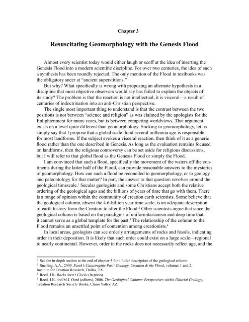
same order (based on time) must be true everywhere on Earth for <strong>the</strong> column to be truein <strong>the</strong> sense that it is used by geologists. These ordered arrangements of rocks and fossilsare very incomplete relative to <strong>the</strong> geological column, even in <strong>the</strong> rare areas where mostof <strong>the</strong> subdivisions are present. 5 For this reason, <strong>the</strong> global column requires pieces to be“assembled” from many different places. The “complete” column is <strong>the</strong>refore an intellectualconstruct, not something observed in nature. No geologist can demonstrate <strong>the</strong>physical reality of <strong>the</strong> entire column.Local examples are always consistent <strong>with</strong> <strong>the</strong> column, but that is because <strong>the</strong>column was <strong>the</strong> original template by which <strong>the</strong> rocks were originally ordered. Sometimes,<strong>the</strong> actual order of rocks and fossils does not match <strong>the</strong> proposed column, but <strong>the</strong>seexceptions are always explained by subsidiary <strong>the</strong>ories. I view <strong>the</strong> geological column as ageneral sequence in relation to <strong>the</strong> eras, such as going upward, <strong>the</strong> Precambrian, Paleozoic,Mesozoic, and Cenozoic, but <strong>the</strong>re are many problems <strong>with</strong> finer divisions. 6,7,8I have a better way to view <strong>the</strong> Flood in relation to geology, fossils, and geomorphology.It is to see <strong>the</strong> investigation of <strong>the</strong> past as history and to go to <strong>the</strong> most reliablehistorical document in <strong>the</strong> world—<strong>the</strong> Bible. This bypasses <strong>the</strong> arguments about <strong>the</strong>geological column too. The method is to identify <strong>the</strong> key events of <strong>the</strong> Flood from <strong>the</strong>historical narrative, and to infer geological and geomorphological processes and <strong>the</strong>irrelative timing. This allows us to directly examine <strong>the</strong> data from <strong>the</strong> actual mechanismof formation—<strong>the</strong> Genesis Flood.Dr. Tas Walker from Creation Ministries International of Australia, has developeda table of events for <strong>the</strong> Flood which is based on Scripture, 9 and is similar to <strong>the</strong> generalmodel of <strong>the</strong> Flood developed by John Whitcomb and Henry Morris in The GenesisFlood. 10 Carl Froede 11 also developed a classification system for <strong>the</strong> Flood that is similarto Walker’s classification. These authors view <strong>the</strong> rocks and fossils from <strong>the</strong> point of viewof <strong>the</strong> creation and Flood and not from evolution, uniformitarian, deep time assumptions.The data of geology is generally <strong>the</strong> same, it is <strong>the</strong> worldview that is different (Figure<strong>3.</strong>1). For simplicity, I will use Walker’s scheme in <strong>the</strong> following discussions.The Biblical Geological ModelWalker’s classification includes criteria for defining his stages and phases (Figure<strong>3.</strong>2). For instance, dinosaur eggs and tracks made by live dinosaurs in Flood sediments5Woodmorappe, J., 1999. The Mythology of Modern Dating Methods: Why million/billion-year resultsare not credible, Institute for Creation Research, Dallas, TX.6<strong>Oard</strong>, M.J., 2006. The geological column is a general Flood order <strong>with</strong> many exceptions. In, Reed, J.K. andM.J. <strong>Oard</strong> (editors), The Geological Column: Perspectives <strong>with</strong>in Diluvial Geology, Creation Research SocietyBooks, Chino Valley, AZ, pp. 99–121.7<strong>Oard</strong>, M.J., 2010. Is <strong>the</strong> geological column a global sequence? Journal of Creation 24(1):56–64.8<strong>Oard</strong>, M.J., 2010. The geological column is a general Flood order <strong>with</strong> many exceptions. Journal ofCreation 24(2):78–82.9Walker, T., 1994. A Biblical geological model. In, Walsh, R.E. (editor), Proceedings of <strong>the</strong> Third InternationalConference on Creationism, technical symposium sessions, Creation Science Fellowship, Pittsburgh, PA, pp.581–592.10Whitcomb, Jr., J.C. and H.M. Morris, 1961. The Genesis Flood, Baker Book House, Grand Rapids, MI.11Froede Jr., C.R., 1995. A proposal for a creationist geological timescale. Creation Research Society Quarterly32:90–94.
would indicate that we are looking at sediments deposited during <strong>the</strong> first half of <strong>the</strong>Flood, called <strong>the</strong> Inundatory Stage. This is based on <strong>the</strong> biblical narrative’s noting that allair-breathing land animals were dead before <strong>the</strong> Floodwater had covered all <strong>the</strong> land byDay 150. 12,13Figure <strong>3.</strong>1. Interpretations of <strong>the</strong> data depend upon a person’s worldview (courtesy of CMI).Genesis 6-9 describes a global Flood that lasted 371 days. A flood is an event inwhich water rises above its normal levels and <strong>the</strong>n retreats back to those levels. Thiswould be true on any scale. Therefore, in <strong>the</strong> biblical Flood, we would expect a FloodingStage, which corresponds to Walker’s Inundatory Stage or <strong>the</strong> 21 weeks of prevailing in<strong>the</strong> Whitcomb-Morris model. This stage is logically followed by <strong>the</strong> Retreating Stage,or <strong>the</strong> Recessive Stage in Walker’s model, which corresponds <strong>with</strong> <strong>the</strong> 31 weeks ofassuaging in <strong>the</strong> Whitcomb-Morris model. All of <strong>the</strong> geomorphology discussed in thisbook will focus on this second stage of <strong>the</strong> Flood.12<strong>Oard</strong>, M.J., 2002. Newly discovered dinosaur megatracksites support Flood model. Journal of Creation16(3):5–7.13<strong>Oard</strong>, M.J., 2006. It’s plain to see: flat land surfaces are strong evidence for <strong>the</strong> Genesis Flood.Creation Ex Nihilo 28(2):34–37.
Figure <strong>3.</strong>2. Tas Walker’s biblical geological model for biblical earth history (courtesy ofTas Walker, http://biblicalgeology.net/).Figure <strong>3.</strong><strong>3.</strong> Graph of <strong>the</strong> timing of <strong>the</strong> Flooding and Retreating Stages <strong>with</strong> Walker’s five phases(drawn by John Reed).
Figure <strong>3.</strong>3 presents a graph estimating relative sea level at various stages of <strong>the</strong> Flood.It notes two stages and five phases, <strong>with</strong> <strong>the</strong> water reaching its zenith by Day 150. 14 Somecreationists think <strong>the</strong> Flood peaked in 40 days 15 or possibly between Day 40 and Day 150.In contrast to those who believe <strong>the</strong> Flood peaked at Day 40, I believe <strong>the</strong>re is compellingScriptural evidence that <strong>the</strong> Ark did not float until Day 40 and hence <strong>the</strong> Flood could nothave peaked on Day 40. 16,17Fur<strong>the</strong>rmore, we learn that <strong>the</strong> Ark grounded on <strong>the</strong> “mountains of Ararat” on Day150. This was after <strong>the</strong> Bible states in Genesis 7:24 that <strong>the</strong> water prevailed upon <strong>the</strong>Earth one hundred and fifty days. It was at <strong>the</strong> end of 150 days that <strong>the</strong> mechanisms of<strong>the</strong> Flood described in Scripture as <strong>the</strong> “fountains of <strong>the</strong> great deep” and <strong>the</strong> “windowsof heaven” likely were shut:Also <strong>the</strong> fountains of <strong>the</strong> deep and <strong>the</strong> floodgates of <strong>the</strong> sky were closed, and<strong>the</strong> rain from <strong>the</strong> sky was restrained; and <strong>the</strong> water receded steadily from <strong>the</strong>earth, and at <strong>the</strong> end of one hundred and fifty days <strong>the</strong> water decreased (Genesis8:2, 3 NASB).This historical marker of maximum Flood stage provides <strong>the</strong> basis for geological inference.It means that <strong>the</strong>re followed 221 days of receding water. This would have initiateda period during which significant erosion, deposition, and <strong>the</strong> formation of landformswould have occurred.The plot of relative sea level in Figure <strong>3.</strong>3 is only a rough estimate. If we could seea real plot in detail, it would likely show hundreds of oscillations of sea level causedby at least five mechanisms, 18 such as tides, tsunamis, local and distant vertical crustalmovements, and <strong>the</strong> dynamics of fast water currents on shallow submerged areas of largeextent. 19 A hypo<strong>the</strong>sis for dinosaur eggs and tracks early in <strong>the</strong> Flood on briefly exposeddiluvial sediments (BEDS) during a relative sea level fall has been developed elsewhere.18,20,21,22,2314<strong>Oard</strong>, M.J., 2011. Dinosaur Challenges and Mysteries: How <strong>the</strong> Genesis Flood Makes Sense of DinosaurEvidence Including Tracks, Nests, Eggs, and Scavenged Bones. Creation Book Publishers, Powder Springs, GA,pp. 163–166.15Hunter, M.J., 2000. Scriptural constraints on <strong>the</strong> variation of water level during <strong>the</strong> Genesis Flood. Journalof Creation 14(2):91–94.16Barrick, W.D. and R. Sigler, 200<strong>3.</strong> Hebrew and geologic analyses of <strong>the</strong> chronology and parallelism of <strong>the</strong>Flood: implications for interpretation for <strong>the</strong> geologic record. In, Ivey, Jr., R. L. (editor), The Fifth InternationalConference on Creationism, technical symposium sessions, Creation Science Fellowship, Pittsburgh, PA,pp. 397–408.17Barrick, W.D., 2008. Noah’s flood and its geological implications. In, Mortenson, T. and T.H. Ury (editors),Coming to Grips <strong>with</strong> Genesis: Biblical Authority and <strong>the</strong> Age of <strong>the</strong> Earth, Master Books, Green Forest, AR,pp. 251–281.18<strong>Oard</strong>, Ref. 14, pp. 1–176.19Barnette, D.W. and J.R. Baumgardner, 1994. Patterns of ocean circulation over <strong>the</strong> continents during Noah’sFlood. In, Walsh, R.E. (editor), Proceedings of The Third International Conference on Creationism, technicalsymposium sessions, Creation Science Fellowship, Pittsburgh, PA, pp. 77–86.20<strong>Oard</strong>, M.J., 1995. Polar dinosaurs and <strong>the</strong> Genesis Flood. Creation Research Society Quarterly 32:47–56.21<strong>Oard</strong>, M.J., 2002. Newly discovered dinosaur megatracksites support Flood model. Journal of Creation16(3):5–7.22<strong>Oard</strong>, M. J., 200<strong>3.</strong> Could dinosaurs make tracks and lay eggs early in <strong>the</strong> Flood? Creation Research SocietyQuarterly 40(2):119–12<strong>3.</strong>23<strong>Oard</strong>, M.J., 2009. Dinosaur tracks, eggs, and bonebeds. In, <strong>Oard</strong>, M.J. and J.K. Reed (editors), Rock SolidAnswers: The Biblical Truth Behind 14 Geological Questions, Master Books, Green Forest, AR, and CreationResearch Society Books, Chino Valley, AZ, pp. 245–258.
Since geomorphology is <strong>the</strong> study of landforms and <strong>the</strong> Earth’s surface, I will focuson <strong>the</strong> time during <strong>the</strong> Flood when rising continents and sinking ocean basins caused <strong>the</strong>large-scale drainage of water into <strong>the</strong> oceans. It was during this time that <strong>the</strong> rapid runofferoded many of <strong>the</strong> landforms and created <strong>the</strong> bathymetry (<strong>the</strong> depth) and shape of <strong>the</strong>ocean basins.The Two Phases of <strong>the</strong> Retreating StageWalker identifies <strong>the</strong> second and last stage as <strong>the</strong> Recessive Stage <strong>with</strong> two phases,<strong>the</strong> Abative and Dispersive. This terminology seems too technical, and so I will call <strong>the</strong>m<strong>the</strong> Retreating Stage that includes <strong>the</strong> Sheet Flow Phase and <strong>the</strong> subsequent ChannelizedFlow Phase (Figure <strong>3.</strong>4). As we will see, this two phase retreat of large-scale flooding canexplain many geomorphological mysteries. During <strong>the</strong> Sheet Flow Phase, water wouldmove in wide currents across <strong>the</strong> mostly flooded Earth. These currents might range upto a thousand miles wide because <strong>the</strong> entire planet was still mostly flooded at this time.There were few mountain ranges or plateaus to block and break up <strong>the</strong> flow. Current sizeand velocity would depend on global flow patterns in <strong>the</strong> temporary global ocean.Figure <strong>3.</strong>4. Walker’s two stages of <strong>the</strong> Flood (left) <strong>with</strong> <strong>the</strong> two phases of <strong>the</strong> Retreating Stage (right).(Stages and phases renamed and drawn by Mrs. Melanie Richard).
The historical narrative gives us ano<strong>the</strong>r clue about <strong>the</strong> duration of this system.Although <strong>the</strong> location of <strong>the</strong> Ark was not representative of <strong>the</strong> entire planet, it doesprovide <strong>the</strong> only clue we have. It states that o<strong>the</strong>r mountain tops began to appear a littlemore than 70 days into <strong>the</strong> Retreating Stage. As sea level continued to drop relative to <strong>the</strong>continents, rising mountains and plateaus would increasingly deflect and disrupt <strong>the</strong> sheetflow. Water would have flowed around <strong>the</strong>se obstacles, eventually moving in largechannels ra<strong>the</strong>r than sheets. During this Channelized Flow Phase, <strong>the</strong> channels wouldcontinuously diminish in size and volume. Channels that might have started off ahundred miles wide would shrink to a much smaller size as more land was exposed.Ano<strong>the</strong>r important consideration is that <strong>the</strong> timing of <strong>the</strong>se phases was relative to<strong>the</strong> location of <strong>the</strong> Ark. The nature of sheet and channelized flow would depend on <strong>the</strong>elevation of <strong>the</strong> underlying land surface. Thus both sheet and channel flow could havebeen ongoing, depending on <strong>the</strong> location. For example, as <strong>the</strong> Rocky Mountains rose,channelized flow would mark that area, even though sheets of water still covered whatwould become <strong>the</strong> Gulf Coast. Figure <strong>3.</strong>5 illustrates <strong>the</strong> transition from <strong>the</strong> Sheet FlowPhase to <strong>the</strong> Channelized Flow Phase.Similarities to Flash FloodsIn a flash flood, water rises rapidly. That rapid rise is <strong>the</strong> main difference betweena river flood and a flash flood. After <strong>the</strong> initial rapid rise in a flash flood, <strong>the</strong> rise of <strong>the</strong>water slows. The flood finally peaks and <strong>the</strong>n begins to abate. As <strong>the</strong> water subsides,more bars, rocks, and land become exposed, forcing <strong>the</strong> water more and more intoconfined channels.There are several similarities between flash floods and <strong>the</strong> narrative of <strong>the</strong> Bibleand its derivative phases (Figure <strong>3.</strong>3). As <strong>the</strong> biblical Flood began, it rapidly inundated<strong>the</strong> lowlands, based on <strong>the</strong> abrupt and catastrophic initiation of its mechanisms. Accordingto Genesis 7:11b (NASB) “…on <strong>the</strong> same day all <strong>the</strong> fountains of <strong>the</strong> great deep burstopen, and <strong>the</strong> floodgates of <strong>the</strong> sky were opened.” The violence of <strong>the</strong>se two mechanismswas great, and toge<strong>the</strong>r <strong>the</strong>y caused 40 days and nights of global rain. At <strong>the</strong> end of thattime, <strong>the</strong> global rain abated, although <strong>the</strong> water “prevailed” ano<strong>the</strong>r 110 days, implyinga continued, yet slower rise of <strong>the</strong> Floodwater until Day 150. The time between Day 40and Day 150 would have been similar to <strong>the</strong> slow rise of a flash flood after its initial rush.Like flash floods, <strong>the</strong> great biblical Flood <strong>the</strong>n began to subside, slowly at first <strong>with</strong> sheetflow gradually becoming channelized, <strong>the</strong> same as <strong>the</strong> decrease in a flash flood.
Figure <strong>3.</strong>5. Transition from sheet flow tochannelized flow during <strong>the</strong> Retreating Stageof <strong>the</strong> Flood (drawn by Mrs. Melanie Richard).The Floodwater Eroded and Shaped <strong>the</strong>Earth’s SurfaceThe characteristic activity during <strong>the</strong> final221 days of <strong>the</strong> biblical Flood would havebeen erosion. Moving water is an extremelypowerful erosive agent, and <strong>the</strong> scale of <strong>the</strong>moving water was unprecedented during thosemonths. Water seeks its own level and <strong>the</strong>mechanism causing <strong>the</strong> runoff during <strong>the</strong> Floodis described in Psalm 104:6-9, which will beexplored in Part II. In summary, two key eventsare described; <strong>the</strong> rising of <strong>the</strong> mountains and<strong>the</strong> lowering of valleys. On a global scale, thatwould have included <strong>the</strong> elevation of continentsand <strong>the</strong> sinking of ocean basins. Thesetwo actions would have created a tremendousimpetus for water to flow off of continents andinto ocean basins. In places where <strong>the</strong> upliftand sinking were over short distances, <strong>the</strong> rushof water would have been incredible.This new motion would have resulted inlarge-scale erosion. The volume of water was very great and <strong>the</strong> velocity would havebeen high, especially where land was rising out of <strong>the</strong> water. Both soft sediment andhard rock would have experienced <strong>the</strong> erosive power of <strong>the</strong> water, because <strong>the</strong>y coveredmuch of <strong>the</strong> continents. Evidence shows that thousands of feet of sediments were erodedin some places, for instance erosion was up to 20,000 feet (6,100 m) in <strong>the</strong> Appalachians(see <strong>Chapter</strong> 8 and Appendix 4).It is just not <strong>the</strong> fact of erosion on <strong>the</strong> continents that is important evidence for <strong>the</strong>Flood, but it is <strong>the</strong> character of <strong>the</strong> erosion. Because of <strong>the</strong> unique scale of <strong>the</strong> processes,<strong>the</strong> eroding waters (transporting sediments and rock along <strong>the</strong> bottom) would haveformed features and landforms unlike those created by modern low-energy, smaller scalewater flow. The inability of geomorphology to explain <strong>the</strong>se features <strong>with</strong>in <strong>the</strong> uniformitarianparadigm indicates <strong>the</strong> necessity of looking for ano<strong>the</strong>r paradigm—that of a globalflood. The amount and character of Flood erosion will be examined in Part III.Since <strong>the</strong> Retreating Stage of <strong>the</strong> Flood had two phases, each phase would be expectedto have formed features particular to that phase. Likewise, <strong>the</strong> order of <strong>the</strong> phases issignificant; we should expect to find landforms created by <strong>the</strong> Channelized Flow Phasesuperimposed on top of those formed during <strong>the</strong> Sheet Flow Phase. Figure <strong>3.</strong>6 shows <strong>the</strong>deposition of <strong>the</strong> Absaroka Volcanics, nor<strong>the</strong>rn and eastern Yellowstone Park and vicinity,followed by planing during sheet flow and channelized erosion forming canyons.
The presence and order of <strong>the</strong>se landforms provide powerful evidence for <strong>the</strong> realityof <strong>the</strong> Flood. 24 The characteristic landforms of <strong>the</strong> Sheet Flow Phase are large planationsurfaces (see Volume II), and <strong>the</strong> characteristiclandforms of <strong>the</strong> ChannelizedFlow Phase are canyons and valleys,wind and water gaps, pediments, andsubmarine canyons (see Volume III).Figure <strong>3.</strong>6. Schematic of sheet flow erosionthat transforms into channelized flow erosionin <strong>the</strong> Absaroka Volcanics of north centralWyoming and south central Montana (drawnby Mrs. Melanie Richard).Figure <strong>3.</strong>6a. Deposition of <strong>the</strong> multiplevolcanic landslides of Absaroka Volcanics,which is over 6,000 feet (1,830 m) thick andcovers about 9,000 mi 2 (23,000 km 2 ).Figure <strong>3.</strong>6b. Sheet deposition gave way tosheet erosion forming a planation surface,which transformed into channelized erosion.Figure <strong>3.</strong>6c. Channelized erosion cuts canyonsup to 4,000 feet (1,220 m) deep before<strong>the</strong> Floodwater finally drains.24<strong>Oard</strong>, M.J., 2008. Flood by Design: Receding Water Shapes <strong>the</strong> Earth’s Surface, Master Books,Green Forest, AR.