Knave Hill, Stonton Wyville, Leicestershire - Wessex Archaeology
Knave Hill, Stonton Wyville, Leicestershire - Wessex Archaeology
Knave Hill, Stonton Wyville, Leicestershire - Wessex Archaeology

Create successful ePaper yourself
Turn your PDF publications into a flip-book with our unique Google optimized e-Paper software.
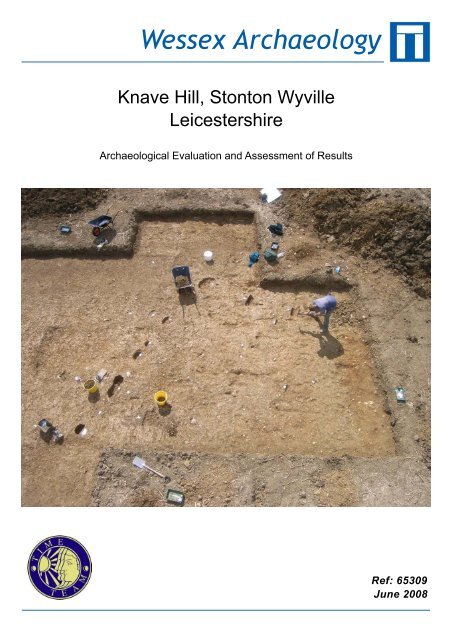
<strong>Wessex</strong> <strong>Archaeology</strong><strong>Knave</strong> <strong>Hill</strong>, <strong>Stonton</strong> <strong>Wyville</strong><strong>Leicestershire</strong>Archaeological Evaluation and Assessment of ResultsRef: 65309June 2008
<strong>Knave</strong> <strong>Hill</strong>, <strong>Stonton</strong> <strong>Wyville</strong>, <strong>Leicestershire</strong>Archaeological Evaluation and Assessment of ResultsPrepared on behalf of:Videotext Communications Ltd49 Goldhawk RoadLONDONSW1 8QPBy:<strong>Wessex</strong> <strong>Archaeology</strong>Portway HouseOld Sarum ParkSALISBURYWiltshireSP4 6EBReport reference: 65309.01May 2008© <strong>Wessex</strong> <strong>Archaeology</strong> Limited 2008, all rights reserved<strong>Wessex</strong> <strong>Archaeology</strong> Limited is a Registered Charity No. 287786
<strong>Knave</strong> <strong>Hill</strong>, <strong>Stonton</strong> <strong>Wyville</strong>, <strong>Leicestershire</strong>Archaeological Evaluation and Assessment of ResultsSummaryAcknowledgementsContents1 BACKGROUND..................................................................................................11.1 Introduction................................................................................................11.2 Site Location, Topography and Geology..................................................11.3 Archaeological Background......................................................................11.4 Previous Archaeological Work .................................................................22 AIMS AND OBJECTIVES.................................................................................33 METHODS...........................................................................................................33.1 Geophysical Survey....................................................................................33.2 Landscape and Earthwork Survey...........................................................33.3 Evaluation Trenches ..................................................................................34 RESULTS.............................................................................................................44.1 Introduction................................................................................................44.2 Geophysical Survey....................................................................................44.3 Evaluation Trenches ..................................................................................5Introduction..................................................................................................5Trench 1 (Figures 3-5) ................................................................................6Trench 2 (Figure 6) .....................................................................................7Trench 3 (Figure 7) .....................................................................................7Trench 4 (Figure 8) .....................................................................................75 FINDS ...................................................................................................................85.1 Introduction................................................................................................85.2 Pottery .........................................................................................................95.3 Fired Clay .................................................................................................105.4 Flint ...........................................................................................................105.5 Coins..........................................................................................................105.6 Metalwork.................................................................................................115.7 Animal Bone .............................................................................................115.8 Other Finds...............................................................................................126 PALAEO-ENVIRONMENTAL EVIDENCE.................................................126.1 Introduction..............................................................................................126.2 Charred Plant Remains...........................................................................136.3 Wood Charcoal.........................................................................................146.4 Land Molluscs ..........................................................................................146.5 Potential ....................................................................................................147 DISCUSSION.....................................................................................................147.1 Area 1 ........................................................................................................147.2 Area 2 ........................................................................................................157.3 Conclusions...............................................................................................158 RECOMMENDATIONS ..................................................................................15i
9 ARCHIVE ..........................................................................................................1610 REFERENCES ..................................................................................................17TablesTable 1Table 2Finds totals by material type and by trenchPottery totals by ware typeAppendix 1: Trench SummariesFiguresFront cover Trench 1 under excavationFigure 1 Location of site and trenchesFigure 2 Results of geophysical surveyFigure 3 Plan of Trench 1Figure 4 Trench 1: position of more defined, substantial postholesFigure 5 Trench 1: selected featuresPlate 1: View of Trench 1, from the north-eastPlate 2: Posthole 1013, from the westPlate 3: Small pit 154 before excavationPlate 4: Fire pit 150Figure 6 Trench 2: planPlate 5: Trench 2, from the northFigure 7 Trench 3: planPlate 6: Trench 3, from the northFigure 8 Trench 4: plan showing defined, substantial postholesPlate 7: Trench 4, from the north-eastFigure 9 Site features and phasing, Trenches 1, 2 and 4Back cover Trench 1 under excavationii
<strong>Knave</strong> <strong>Hill</strong>, <strong>Stonton</strong> <strong>Wyville</strong>, <strong>Leicestershire</strong>Archaeological Evaluation and Assessment of ResultsSummaryIn July 2007 an archaeological evaluation was undertaken by Channel 4’s ‘TimeTeam’ at the site of <strong>Knave</strong> <strong>Hill</strong>, <strong>Stonton</strong> <strong>Wyville</strong>, <strong>Leicestershire</strong> (NGR 474190293356), to investigate the existence of a possible Anglo-Saxon settlement site. Thisarea had been previously identified by a systematic fieldwalking survey whichrecovered the largest concentration of Anglo-Saxon pottery identified by fieldwalking in <strong>Leicestershire</strong> to date.Geophysical survey and excavation identified a large ‘D’-shaped enclosure, whichproved on excavation to date to the Late Iron Age to Romano-British period. Anotherpossible enclosure was identified lying 120m to the east. In addition, excavationrevealed two possible Anglo-Saxon post-built structures, suggesting that the Saxonsettlement focus lies to the north-west of the ‘D’-shaped enclosure. This activity wasnot visible to the geophysical survey.Dating evidence recovered was relatively limited (pottery and coins), and the Saxonpottery in particular is not susceptible to close dating; it is currently dated broadly asearly/middle Anglo-Saxon (5 th to 8 th century AD). The date range of the Romano-British finds (pottery and coins) appears to span the period from 1 st century AD (withsome possible pre-conquest pottery) to 4 th century AD, although continuity of activitythroughout the period cannot be demonstrated, and the four late Romano-British coinsrecovered, three of which were perforated for suspension, could in fact have beencollected and re-used during the Anglo-Saxon period.iii
<strong>Knave</strong> <strong>Hill</strong>, <strong>Stonton</strong> <strong>Wyville</strong>,<strong>Leicestershire</strong>Archaeological Evaluation and Assessment of ResultsAcknowledgementsThis programme of post-excavation and assessment work was commissioned andfunded by Videotext Communications Ltd, and <strong>Wessex</strong> <strong>Archaeology</strong> would like tothank the staff at Videotext, and in particular Michael Douglas (Series Editor),Melinda Corkery (Production Manager), Jim Mower (Assistant Producer), Jon Willers(Researcher) and Jenny James (Production Coordinator) for their considerable helpduring the recording and post-excavation work.The geophysical survey was undertaken by John Gater, Claire Stephens and EmmaWood of GSB Prospection. The field survey was undertaken by Henry Chapman fromthe University of Birmingham and landscape survey and map regression wasundertaken by Stewart Ainsworth of English Heritage. The excavation strategy wasdevised by Mick Aston. The on-site recording was co-ordinated by Cheralynne Hydeof <strong>Wessex</strong> <strong>Archaeology</strong>. On-site finds processing was carried out by Laura Catlin,also of <strong>Wessex</strong> <strong>Archaeology</strong>.The excavations were undertaken by Time Team’s retained archaeologists, PhilHarding (<strong>Wessex</strong> <strong>Archaeology</strong>), Ian Powlesland, Raksha Dave, Matt Williams andTracey Smith assisted by Neil Finn, Andy Hyam, John Thomas, Jess Bryan, KieranArmitage and Hari Jacklin. Metal detector survey was carried out by Robert Wardand Trevor Rainer.The archive was collated and all post-excavation assessment and analysis undertakenby <strong>Wessex</strong> <strong>Archaeology</strong>. This report was compiled by Naomi Hall and CheralynneHyde with specialist reports prepared by Lorraine Mepham (finds) with Dr NicholasCooke (coins) and Jessica Grimm (animal bone). Palaeoenvironmental material wasassessed by Dr Chris Stevens. Illustrations were prepared by Kenneth Lymer. Thepost-excavation project was managed on behalf of <strong>Wessex</strong> <strong>Archaeology</strong> by LorraineMepham.Finally thanks are extended to the landowner, Brudenell Estates and the presenttenants Ian and Rosemary Hemington, for allowing access to the Site for geophysicalsurvey and archaeological evaluation.iv
<strong>Knave</strong> <strong>Hill</strong>, <strong>Leicestershire</strong>Archaeological Evaluation and Assessment of Results1 BACKGROUND1.1 Introduction1.1.1 <strong>Wessex</strong> <strong>Archaeology</strong> was commissioned by Videotext Communications Ltdto undertake a programme of archaeological recording and post-excavationwork on an archaeological evaluation undertaken by Channel 4’s ‘TimeTeam’ at the site of <strong>Knave</strong> <strong>Hill</strong>, West View Farm, <strong>Stonton</strong> <strong>Wyville</strong> nearMarket Harborough, <strong>Leicestershire</strong> (hereafter the ‘Site’) (Figure 1).1.1.2 This report documents the results of archaeological survey and evaluationundertaken by Time Team, and presents an assessment of the results of theseworks.1.2 Site Location, Topography and Geology1.2.1 The Site consisted of a large field of approximately 18 hectares, centred onNGR 474190 293356 and forming a rough ‘L’ shape, all four trencheslocated in the southern section of this field. The field lies to the south of thefarm buildings of West View Farm and within the parish of <strong>Stonton</strong> <strong>Wyville</strong>.1.2.2 The field slopes gently to the north from a height of 90m aOD to 110m aODand was under plough at the time of evaluation. About 900m to the northnorth-eastis a hill known as Langton Caudle. The underlying geology isboulder clay and silts (Geological Survey of Great Britain sheet 170).1.3 Archaeological BackgroundPrehistoric (-43AD)1.3.1 A mound lies on top of the hill called Langton Caudle, just to the north of theSite. No archaeological investigation appears to have been made but it isprobably a Bronze Age barrow (English Heritage NMR Monument Report344112).1.3.2 A Bronze Age trackway is believed to run along the ridge throughSaddington, Kibworth Harcourt, Illston and Tilton crossing the route of thelater Roman road almost at right angles near Shangton, to the north-west ofthe Site.1.3.3 Various isolated finds of flintwork and pottery have been found in the area(English Heritage NMR Activity Reports), including a concentration to thenorth of the Site near Fox Coverts and on the south-east slope of LangtonCaudle (<strong>Leicestershire</strong> County Council, MLE2464 and MLE8473).1.3.4 A double ditched linear feature with a possible pit alignment has beenidentified just to the south of Langton Road as it passes out of the village ofCranoe (<strong>Leicestershire</strong> County Council, MLE1435).1
1.3.5 There are several known or suspected Iron Age hilltop settlements somedistance to the north, at Burrough-on–the <strong>Hill</strong>, Tilton and Ridlington (Liddle1982, 22). Iron Age material has also been found in the area (<strong>Leicestershire</strong>County Council, MLE1473, 1475, 6495, 6593, 8323, 10268 and 10373),including in the vicinity of the Site (<strong>Leicestershire</strong> County Council,MLE9087).Romano-British (43-410 AD)1.3.6 Just over 2km to the north-east lies the course of Gartree road, a Roman roadrunning from Leicester towards Medbourne (<strong>Leicestershire</strong> County CouncilMLE2292).1.3.7 Fieldwalking to the north-east of <strong>Stonton</strong> <strong>Wyville</strong> in the village of Gloostonproduced Roman and Anglo-Saxon material including box flue tile as well asmedieval pottery (English Heritage NMR Activity Report 1306680). Otherconcentrations of Roman finds have been identified by field walking(<strong>Leicestershire</strong> County Council MLE1470, 1474, 2465, 8234, 8472, 9130and 9521)1.3.8 The Site lies about 19.5km to the south-east of the Leicester (Ratae) a largeRoman town and the former capital of the Coritani (Liddle 1982, 30).Anglo-Saxon (410-1066)1.3.9 A number of sherds of Anglo-Saxon pottery have been found in the area. Thevillage of <strong>Stonton</strong> <strong>Wyville</strong> itself is thought to date from the Late Anglo-Saxon period (<strong>Leicestershire</strong> County Council, MLE10048). The village ofChurch Langton to the west was also an Anglo-Saxon settlement (Lee andMcKinley 1964, 193-213).Medieval (1066-1499)1.3.10 <strong>Knave</strong> <strong>Hill</strong> is within the hundred of Gartree (Lee and McKinley 1964, 1-5).In 1086 the holding of <strong>Stonton</strong> <strong>Wyville</strong> formed part of the estates of Hugh deGrentemesnil and took its name from the under-tenant Hugh Widville or<strong>Wyville</strong> (ibid., 308-12). The present day village is much smaller than themedieval settlement and remains of this larger medieval village can be seenas earthworks to the north and south of the modern settlement (EnglishHeritage National Monument Number 17050). The manor-house is built on aslight mound which may have been moated in medieval times (Lee andMcKinley 1964, 308-12). Its position on the east side of the raised sitesuggests that the existing house may represent only one range of a largerhouse. In 1494 when William <strong>Wyville</strong> died the estate passed to his nieceKatherine Warde. The manor was then leased by Sir Robert Brudenell. TheBrudenells obtained full possession of the manor in 1533. There was anattempt to rename the village <strong>Stonton</strong> Brudenell in the 17 th century, and thisname was used as late as the 19 th century, although it was never in commonusage (ibid.).1.4 Previous Archaeological Work1.4.1 A number of Anglo-Saxon settlement sites have so far been located byfieldwalking across the county (Vince 2006, 172-3). Under the <strong>Stonton</strong><strong>Wyville</strong> Survey (1996-2004), initially funded by English Heritage and2
continued by <strong>Leicestershire</strong> County Council, 45 fields in the parish havebeen subjected to field walking (surface artefact collection). Fourconcentrations of Anglo-Saxon pottery were identified from this survey, oneto the north, one to the east and two to the south of the village. The twoconcentrations 1.8km to the south of the village represent the largestconcentration of Anglo-Saxon pottery identified by field walking in<strong>Leicestershire</strong>, producing 245 sherds in total. The Site lies within thisconcentration. The second largest concentration of Anglo-Saxon pottery in<strong>Leicestershire</strong>, produced by the same field walking methods, was at EyeKettleby. Subsequent excavation revealed a settlement with over 40buildings. Some further field walking on the Site has been done by theHallaton Fieldwork Group.2 AIMS AND OBJECTIVES2.1.1 A project design for the work was compiled by Videotext Communications(2007), providing full details of the research aims and methods. A briefsummary is provided here.2.1.2 The aim of the project was to characterise the nature and date of the Site andplace it within its historical, geographical and archaeological context. Ofspecific interest was whether the Site represented an Anglo-Saxon settlementsimilar to that excavated at Eye Kettleby and, if so, what the nature of thissettlement might be.3 METHODS3.1 Geophysical Survey3.1.1 Prior to the excavation of evaluation trenches, a geophysical survey wascarried out across the Site using a combination of resistance and magneticsurvey. The survey grid was set out by Dr Henry Chapman and tied in to theOrdnance Survey grid using a Trimble real time differential GPS system.3.2 Landscape and Earthwork Survey3.2.1 A landscape survey and analysis of the cartographic evidence wasundertaken by Stewart Ainsworth, Senior Investigator of the ArchaeologicalSurvey and Investigation Team, English Heritage. A summary of the findingsare incorporated in the results below.3.3 Evaluation Trenches3.3.1 Four trenches of varying sizes were excavated, their locations determined totarget responses from the geophysical survey and to elucidate the phasingand nature of the archaeology.3.3.2 The trenches were excavated using a combination of machine and handdigging. All machine trenches were excavated under constant archaeologicalsupervision and ceased at the identification of significant archaeologicalremains, or at natural geology if this was encountered first. When machine3
excavation had ceased all trenches were cleaned by hand and archaeologicaldeposits investigated.3.3.3 At various stages during excavation the deposits were scanned by a metaldetector and signals marked in order to facilitate investigation. Theexcavated up-cast was scanned by metal detector.3.3.4 All archaeological deposits were recorded using <strong>Wessex</strong> <strong>Archaeology</strong>’s proforma record sheets with a unique numbering system for individual contexts.Trenches were located using a Trimble Real Time Differential GPS surveysystem. All archaeological features and deposits were planned at a scale of1:20 with sections drawn at 1:10. All principal strata and features wererelated to the Ordnance Survey datum.3.3.5 A full photographic record of the investigations and individual features wasmaintained, utilising colour transparencies, black and white negatives (on35mm film) and digital images. The photographic record illustrated both thedetail and general context of the archaeology revealed and the Site as awhole.3.3.6 At the completion of the work, all trenches were reinstated using theexcavated soil.3.3.7 A unique Site code (KNA 07) was agreed prior to the commencement ofworks. The work was carried out on the 28 th July – 1 st August 2007. Thearchive and all artefacts were subsequently transported to the offices of<strong>Wessex</strong> <strong>Archaeology</strong> in Salisbury where they were processed and assessedfor this report.4 RESULTS4.1 Introduction4.1.1 Details of individual excavated contexts and features, the full geophysicalreport (GSB 2007), the summary of the landscape and earthwork survey anddetails of artefactual and environmental assessments, are retained in theproject archive. Summaries of the excavated sequences can be found inAppendix 1.4.2 Geophysical Survey4.2.1 Geophysical survey (Figure 2) using a magnetometer was carried out in twoareas, covering in total 2.56ha. All data and discussion that follows is takenfrom the report provided by GSB Prospection (2007). The recent harrowingof the field introduced an element of noise that may have masked weakeranomalies; this may introduce a bias against features of certain date, inparticular those of the Anglo-Saxon period.4.2.2 The main discovery of the magnetic survey was a D-shaped enclosure. Anumber of pits and ditches were also observed. Ridge and furrow cultivationresponses can be seen throughout the data.4
4.2.3 Small scale ferrous anomalies have not been interpreted individually as theseare usually deemed to have no archaeological relevance, although on anAnglo-Saxon site they could possibly relate to metal finds. They can,however, be seen as sharp peaks within the data.Area 14.2.4 Responses (A) consist of linear and curvilinear ditches; together they form a‘D’ shaped enclosure. Rectilinear anomalies form a smaller enclosure (B)that is clearly associated with the D-shaped enclosure, but how the two relatechronologically is uncertain. Short ditch responses (C) radiate towards thecentre of (A) and divide the internal space of the enclosure. A number of pitlikeanomalies were also noted.4.2.5 Outside of the D-shaped enclosure are further responses of archaeologicalinterest including a ditch length (D) that may be part of an entrance into thecomplex.4.2.6 Ridge and furrow cultivation effects can be seen running on a north-southalignment; the responses were stronger where the archaeological featureshave been cut into by the ploughing.Area 24.2.7 Archaeological responses within this area are not as magnetically strong asthose within Area 1, perhaps suggesting that occupation was concentrated inand around the D-shaped enclosure. Ditches at (E) may form part of whatwas also originally an enclosure, but the remains appear severely damaged.4.2.8 An old field boundary can be seen within the data at (F); this is visible onaerial photographs and old maps prior to its being ploughed out in recenttimes.4.2.9 Anomaly (G), running in an east-west direction, is on a similar alignment to(E). However it is likely that (G) represents a headland or former fielddivision as it marks the northern limit of the ridge and furrow ploughing.4.2.10 A number of pit-type anomalies (H) are visible and although they may havean archaeological origin, they could also be associated with an old quarryknown to have existed to the north-east. Trends within the data may alsohave an archaeological nature but they could equally be due to agriculturaltechniques.4.3 Evaluation TrenchesIntroduction4.3.1 Four trenches were opened over the three day period. Trenches 1, 2 and 4were situated within the first area of geophysical surveying (Area 1). Trench3 was sited much further east within the second area of geophysical survey(Area 2).4.3.2 All trenches saw the removal of between 0.22-0.48m of overlying topsoil andsubsoil material in order to expose the archaeology. In several places thearchaeology was overlain and obscured by medieval ridge and furrow.5
Trench 1 (Figures 3-5)4.3.3 Trench 1 was positioned on the ‘D’-shaped enclosure ditch identified by thegeophysical survey. Stripping revealed a large number of postholes in thenorthern end of the trench beyond the potential enclosure. Further southwithin the enclosed area ditches, gullies and pits were also encountered.4.3.4 Ditch (126), a south-west – north-east aligned linear, corresponded with theenclosure boundary as located by the geophysical survey. The dating materialwithin it (all from secondary fill 127) was a mixture of Late Iron Age andRomano-British pottery; four small sherds in sandy fabrics are currentlyundated and could be Anglo-Saxon, but at present this feature is dated asRomano-British. Although fairly wide the feature was relatively shallowrather than a substantial boundary ditch, and the slightly deeper extension ofthe trench to the east removed all traces of it. Slightly to the south-east but atright angles to it was another ditch (199); this was also seen on thegeophysical survey and appears to be an internal division within theenclosure.4.3.5 A large number of possible postholes were also discovered tot he north of theenclosure ditch. Although many proved to be shallow and diffuse severalwere more substantial, with more distinct edges and a steeper profile (Figure4). Six of the features appeared to be definite postholes - (110), (114), (120),(1013) and the intercutting postholes (1003) and (1005). In addition (108),(182), (188) and (1011) may also be true post holes as they are fairly distinct.Saxon pottery was recovered from these features. In total these features forma definite north-west – south-east aligned posthole alignment and also apossible north-east – south-west alignment forming a return. Thesealignments have been provisionally identified as representing a Saxon postbuilthall (Structure 1), at least 10m long and 4m wide.4.3.6 Four other possible postholes were found within the area defined by the D-shaped enclosure. Postholes (160), (162), (164) and (170) form a north-east –south-west line on the same alignment as ditch (126). Another isolatedpossible posthole (156) was found just to the south-east of (126). Otherfeatures in this area are likely to be the result of root disturbance.4.3.7 Two features containing burnt material were also found within the enclosure,(146) and (154) (Figure 5, Plate 3). Both seem to represent the dumping ofhearth material rather than in situ burning.4.3.8 At the far southern end of the trench a pit (150) was discovered (Figure 5,Plate 4). It had a flat base with a number of distinct indentations. There werealso indications of in situ burning. It was suggested that this could have beena clamp kiln, a simple pit for firing pottery, and that the indentations couldhave supported a raised platform, thereby creating an updraft. Very few pitclamps of late Iron Age and Romano-British date have been identified inBritain and those that are known generally contained significant ashydeposits and large numbers of pottery sherds (Swan 1984, 54). Only a littlepottery was recovered from the feature and these sherds showed no evidenceof ‘wasters’. Moreover, the deposits within the feature contained nosignificant amounts of ash or charcoal. It may be that this feature was a6
simple fire pit and used either for cooking or heating, and the indentations inthe base may be traces of a structure associated with this.4.3.9 South-east of pit (150) was a diffuse area containing a number of intercuttingfeatures (140), (142) and (1017) into which a box section was placed. Feature(140) in particular was extremely diffuse and irregular and may well be a treethrow. Features (1017) and (142) could be pits cut into this disturbance, butno clear shape in plan could be observed. These features do, however, relateto a response in the geophysical survey.Trench 2 (Figure 6)4.3.10 Trench 2 was positioned to the east of Trenches 1 and 4 and positioned on alinear geophysical anomaly thought to be an internal division within theenclosure.4.3.11 Stripping revealed a north-west – south-east aligned ditch (203) confirmingthis. The deposits within it suggest episodes of gradual silting. Finds werefairly sparse suggesting that this is at least a little distant from any permanentsettlement. Pottery recovered from the deposits indicates that the ditch siltedup during the Roman period.Trench 3 (Figure 7)4.3.12 Trench 3 was located approximately 140m to the east of Trench 2 within thesecond area of geophysical surveying, and positioned on another possibleenclosure identified by the survey.4.3.13 Stripping revealed several linear features. A curvilinear ditch (304)corresponded to the geophysical response, but three other ditches or gullies(313), (315) and (317) were also discovered.4.3.14 Ditch (304) was aligned approximately north-west – south-east but can beseen on the geophysical survey to have a north-east – south-west return justto the north-west of the trench. Artefacts from it indicate an early Romano-British date. Just to the north of this feature two possible post-holes wereuncovered (306) and (308). Upon excavation these were considered to bemerely the product of root disturbance but fragments of Romano-British andAnglo-Saxon pottery were recovered from both features.4.3.15 Feature (317) was seen to comprise a wide south-west – north-east alignedditch containing Romano-British pottery. It is cut to the north-east by linear(313) and does not extend beyond this. Ditch (313) was very wide andslightly irregular with very diffuse edges and its nature is therefore uncertain.It contained predominantly Romano-British pottery but a small sherd ofAnglo-Saxon material was also found in the fill.4.3.16 A shallow gully (315) was also found to be cut by ditch (313), and was nottherefore fully visible in plan. Finds date this feature also to the Romano-British period.Trench 4 (Figure 8)4.3.17 Trench 4 was the mostly westerly of the trenches lying beyond the enclosure.Stripping revealed a large number of small postholes as well as traces ofridge and furrow.7
4.3.18 A plough furrow (403) ran north – south along the western edge of theexcavation area.4.3.19 Many of the possible postholes were small, irregular and slightly diffuse andmay well be the result of root disturbance. A number were, however, muchmore distinct. Eight in particular (417), (421), (431), (435), (452), (456),(462) and (476) show a steep-sided profile typical of a posthole. Postholes(417), (431) and (435) form a possible western wall line while (452), (456),(462) and (476) form a possible eastern wall line. These posthole alignmentshave been provisionally identified as forming a second post-built hall(Structure 2), approximately 4.5m wide. Posthole (421) could mark thenorthern extent of the building but, given that this would make the length ofthe hall approximately 6m, it is perhaps more likely that the structureextended beyond the northern limit of the trench. A bone pin or needle wasfound within posthole (421), but otherwise the only dating evidence from thepossible structure is a single sherd of Anglo-Saxon pottery from posthole(452).4.3.20 Five other features may well be definite postholes. Though shallower, (442)and (444) have a fairly steep profile, while (427), (448) and (450) haveshallower sides but are still quite distinct.4.3.21 Within the area contained by the posthole alignments remnants of anoccupation layer (441) were found as well as traces of a possible hearth (437)or dump of hearth material. Finds from the occupation layer support anAnglo-Saxon date for the structure.5 FINDS5.1 Introduction5.1.1 Finds were recovered from all four of the trenches excavated, although fewfinds came from Trench 3. Trench 1 was the most productive in terms offinds, but much of this part of the assemblage came from topsoil. Finds wereadditionally recovered from an unsystematic metal detector survey adjacentto the trenches in Area 1.5.1.2 The assemblage ranges in date from prehistoric to post-medieval, althoughthe majority appears to be of either Romano-British or early/middle Anglo-Saxon date. Only pottery and animal bone were recovered in any quantity;other material types are much more sparsely represented.5.1.3 All finds have been quantified by material type within each context, andtotals by material type and by trench are presented in Table 1. Subsequent toquantification, all finds have been at least visually scanned in order to gainan overall idea of the range of types present, their condition, and theirpotential date range. Spot dates have been recorded for selected materialtypes as appropriate (pottery, metalwork). All finds data are currently held onan Access database, which forms part of the project archive.5.1.4 This section presents an overview of the finds assemblage, on which is basedan assessment of the potential of this assemblage to contribute to an8
understanding of the site in its local and regional context, with particularreference to the possible existence of an Anglo-Saxon settlement on the site.5.2 Pottery5.2.1 Pottery provides the primary dating evidence for the site. The smallassemblage includes material of later prehistoric, Romano-British, Anglo-Saxon, medieval and post-medieval date. Dating has been somewhathampered by the scarcity of diagnostic sherds, and the obvious chronologicalmixing of some contexts; a few sandy wares remain undated at this stage.5.2.2 Condition varies; although the assemblage is fragmentary, the majority of thesherds are in relatively hard-fired fabrics which have suffered a fairly lowlevel of surface/edge abrasion. Mean sherd weight is 21.9g. Conjoiningsherds from one partially reconstructable vessel profile were found in Trench1.5.2.3 The assemblage has been quantified by broad ware type (e.g. sandy ware,shelly ware), and the presence of diagnostic forms noted. Spot dates havebeen recorded on a context by context basis.Prehistoric5.2.4 One sherd from trench 1 (gully 138) in a coarse, rock-tempered fabric, hasbeen tentatively dated as later prehistoric, although completely undiagnostic.Late Iron Age/Romano-British5.2.5 The majority of the assemblage is of Romano-British date, with a few sherdspossibly pre-conquest (174 sherds in total). Wares of Late Iron Age origincomprise the grog-tempered and shelly wares, and a few sherds of the lattertype from Trench 1 (ditch 126, secondary fill), in handmade bead rim forms,could pre-date the conquest period, although they occurred in this contextwith wheelthrown, ‘Romanised’ wares. Other shelly bead rim forms from pit(150) (lower fill) are later, probably mid to late 2 nd century, on the basis ofthe skeuomorphic grooving on the internal rim bevel (a development of theearlier lid-seating). Grog-tempered wares are used for jar forms, often largeand thick-walled; one partial vessel, of probable late 1 st /2 nd century AD date,from possible pit (142) carries elaborate incised (lattice) and combed(curvilinear and vertical) decoration below a neck cordon. Other wares aresandy; these are found in bead rim and everted rim jar forms. No finewareswere recovered.Anglo-Saxon5.2.6 A total of 56 sherds has been dated as early/middle Anglo-Saxon, althoughthese are for the most part undiagnostic. Dating is fairly tentative and, in theabsence of a well dated type series for the county, cannot be more closelydefined within this period (5 th to 8 th century); it can be noted thatdiagnostically middle Anglo-Saxon pottery (e.g. Maxey ware, Ipswich ware)is markedly absent from the county (Vince 2006, 173, 178-9). Most potterydated as Anglo-Saxon came from contexts in Trenches 1 and 4.5.2.7 Most sherds are in sandy fabrics, with prominent subangular quartz grains; afew sherds also contained either shell or oolitic limestone inclusions. Eightsherds contained a mixture of quartz and igneous-derived rock inclusions9
(probably granitic). There are five rim sherds, one also carrying traces ofapplied decoration (probably an elongated vertical boss. Otherwise there areno diagnostic sherds; none are decorated and none burnished. All fabrics arelikely to be at least relatively locally produced. The igneous-derived fabrics,for example, probably originate from the area of the Mountsorrelgranodiorite outcrop in the Charnwood Forest, in the north-west of thecounty. Petrological work has identified a widespread distribution ofearly/middle Anglo-Saxon granitic wares over the midlands and easternEngland, the majority of which were almost certainly produced in theCharnwood Forest (Williams and Vince 1997).Medieval and Post-Medieval5.2.8 A single medieval sherd was recovered – a fine sandy glazed ware fromTrench 2 topsoil.5.2.9 Two post-medieval redwares were recovered, both from topsoil contexts, inTrenches 1 and 3 respectively.5.3 Fired Clay5.3.1 Of the small amount of fired clay recovered, most comprises small,featureless and abraded fragments of uncertain date; these could be structuralin origin. Parts of three objects, however, were identified – one fragmentfrom a triangular loomweight, an Iron Age or Roman type (feature 140); asecond fragment with part of a perforation, presumed to derive from aloomweight (Trench 1 topsoil); and part of a probable spindlewhorl (alsoTrench 1 topsoil).5.4 Flint5.4.1 Eleven struck flints and one piece of burnt, unworked flint were recovered.All the struck flint comprises debitage (flake and core material), which is notchronologically distinctive. There are no retouched or otherwise utilisedpieces.5.5 Coins5.5.1 Four coins were recovered, all from Trench 1, one unstratified and three fromtopsoil. All four are copper alloy denominations of the late 3 rd or 4 th centuriesAD. All are heavily worn, and in one case, corroded, making their attributionto specific periods problematic. The earliest is an irregular radiateantoninanus of the late 3 rd century AD. These irregular copies of ‘official’coinage (sometimes known as ‘Barbarous Radiates’) may have been struck tocompensate for gaps in supply of coinage to Britain and to supply sufficientsmall change for the provinces needs. It is unclear whether these copies wereofficially sanctioned, if at all, but they are common site finds, and seem tohave circulated in the same fashion as officially struck coins. The remainingthree coins all date to the 4 th century AD, although none could be datedclosely.5.5.2 Three of the four coins recovered appear to show signs of deliberate damage.Two were pierced for suspension on a necklace, and in both cases theobverse appears to have been polished smooth. This suggests that they were10
worn on necklaces, with the polishing designed to produce shiny discs ofcopper alloy, erasing the evidence for their use as coins. Heavy scratching onthe obverse and reverse of a third coin also points to some attempt to removethe engraving, perhaps in the early stages of such a polishing process.5.5.3 These coins could, therefore, have been deliberately collected and re-usedduring the Anglo-Saxon period, when such practices are well known.5.6 Metalwork5.6.1 Apart from coins, metalwork comprises objects of copper alloy, iron andlead. All but four small unidentifiable iron fragments (from one context)either came from topsoil, or were unstratified (including metal detectorfinds).5.6.2 The copper alloy objects consist of a fragment from a Romano-Britishtrumpet brooch (2 nd century AD); one post-medieval buckle; a fragment froma post-medieval rumbler bell; a piece of folded sheet, possibly a ‘paper-clip’repair from a post-medieval metal vessel; and a rivet (undated).5.6.3 The ironwork consists largely of nails and other structural items. Otheridentifiable objects include four knife blades, two socketed tools, a boot cleatand two horseshoe fragments. Apart from the horseshoe fragments, which arepost-medieval, none of these objects are chronologically distinctive, nor doestheir provenance allow for dating by association with other artefacts,although it is possible that at least some are of Romano-British or Anglo-Saxon date.5.6.4 The lead consists entirely of waste fragments.5.7 Animal Bone5.7.1 The faunal assemblage comprises 195 animal bone fragments (hand collectedand samples). Conjoining fragments that were demonstrably from the samebone were counted as one bone in order to minimise distortion, and thereforespecimen counts (NISP) given here may differ from the absolute rawfragment counts in the Table 1. On the basis of associated pottery, the boneis mainly Roman or Anglo-Saxon in date. As the assemblage is very small, itis treated here as ‘single period’. Its results are probably not representative.5.7.2 The overall condition of the bone is fair to good, with no context groups inpoor condition. No root etching or eroded surfaces were seen. Only threefragments showed signs of canid gnawing and it is thus unlikely that canidscavenging is a serious biasing factor. 15% of the fragments showed signs ofburning. Most of the fragments were rather small and undiagnostic.However, some charred pig mandible and teeth fragments were seen (pit146). At 6%, the number of loose teeth is normal and indicates that theassemblage was probably not extensively reworked.5.7.3 The identified remains (48%) consist of cattle (n=35), sheep/goat (39), pig(14), horse (2), chicken (1) and goose (2). Of these, eight could be aged andeight measured. Only four of the bones showed signs of butchery. However,the fragmented nature of the bones suggests that the carcasses were heavilybutchered and used. A complete sheep metatarsus from ?pit (142) allowed11
the calculation of a height at the withers of c 56 cm (Teichert 1975). This is anormal value.5.7.4 The upper fill of pit (150) contained the partial skeleton of a sheep. Bothtibiae, two ribs, a scapula and a pelvis fragment as well as part of a humeruswere present. The unfused status of the bones indicates a lamb below 3-4months. As the total length of the tibia was well over that of a neonate(Habermehl 1975), the lamb was probably a few weeks to months old.5.7.5 Posthole (421) contained a bone pin/needle made out of the proximal part ofa horse splint bone. Some of the proximal articulation was still visible. Thedistal part was fashioned into a sharp point and the shaft rounded. Atransverse hole was made through the top. The whole object was highlypolished through use. The date of the object is uncertain since no other datingevidence was recovered from this feature, but it is within a possiblerectangular building outline dated as Anglo-Saxon.5.8 Other Finds5.8.1 Other finds comprise small quantities of ironworking slag; a few fragmentsof lava quernstone (of either Romano-British or Anglo-Saxon date); and oneslab-like piece of limestone, possibly utilised as building material.6 PALAEO-ENVIRONMENTAL EVIDENCE6.1 Introduction6.1.1 Seven samples were taken from the excavations. Those from Trench 1 camefrom four Romano-British and probable Romano-British pits (142, 150, 146and pit/posthole 154). Those from Trench 4 came from probable Anglo-Saxon contexts, a hearth deposit (438) and occupation layer (441). Thesamples were processed for the recovery and assessment of charred plantremains and charcoals.6.1.2 The bulk samples were processed by standard flotation methods; the flotretained on a 0.5 mm mesh, residues fractionated into 5.6 mm, 2mm and1mm fractions and dried. The coarse fractions (>5.6 mm) were sorted,weighed and discarded. Flots were scanned under a x10 – x40 stereobinocularmicroscope and the presence of charred remains quantified (Table3) to record the preservation and nature of the charred plant and woodcharcoal remains. Preliminary identifications of dominant or important taxaare noted below, following the nomenclature of Stace (1997).6.1.3 The samples were generally quite rooty with the exception of those from pit(154) and small pit (146), which were mainly pure charcoal. The degree ofrooting and modern seeds is a good indication of soil activity and thepossibility of later intrusive elements being brought into the context, orreworking of earlier material. This is particularly an issue for the featureswithin Trench 4 where the degree or rooting was very high, including largestems of modern straw and straw roots.12
6.2 Charred Plant Remains6.2.1 There were generally very few charred cereal remains in the samples. Thericher samples came from Trench 1, especially from pit (142), and inparticular the lowest fill (context 1007). This context contained a largenumber of glume bases from hulled wheats including several identifiableglumes of spelt wheat (Triticum spelta) and a spikelet of emmer wheat (T.dicoccum). The sample also contained quite a number of hulled barley grains(Hordeum vulgare) and a relatively large number of hulled barley rachisfragments that could be seen in most instances to be of the six-row variety.The sample also included a single elongated coleoptile or sprout.6.2.2 Weed seeds were very common in these samples comprising mainly largerseeded species including vetches/wild pea (Vicia/ Lathyrus sp.), cleavers(Galium aparine), buttercup (Ranunculus acris/repens/bulbosus), nipplewort(Lapsana communis), oats (Avena sp.) and knotgrass (Polygonum aviculare).Smaller and intermediate sized seeds included perennial rye-grass (Loliumperenne), and clover (Trifolium sp.). The other sample from this featurecontained relatively few cereal remains by comparison.6.2.3 Pit 150 contained several grains of free-threshing wheat (Triticum aestivumsl.) and hulled barley (Hordeum vulgare sl.), but no remains of hulledwheats, emmer or spelt (Triticum dicoccum/spelta). Pit (154) contained onlya single grain of barley, while pit (146) contained no cereal remains. Thesample from pit (146) contained no remains other than a probable stone ofhawthorn (Crataegus monogyna).6.2.4 The two samples from Anglo-Saxon contexts within Trench 4 produced veryfew remains other than a single seeds of vetches/wild pea, oat and a possibleseed of white bryony (Bryonia dioica). A single seed of free-threshing wheatcame from occupation layer (441).6.2.5 The high presence of spelt wheat (Triticum spelta) wheat within pit (142) isconsistent with a Romano-British date at a time when this wheat wasdominant over much of England. Emmer was generally a minor crop acrossmuch of England during the Romano-British period, although it was quiteimportant in some parts of eastern England, persisting in East Anglia (seeGreen 1985). Seeds of vetches have been noted to be frequent upon someRomano-British sites, and the high presence of this weed group has beenassociated with declining soil fertility (Jones 1981).6.2.6 The presence of free-threshing wheat from pit (150) is of some interest asfree-threshing wheat remains are largely absent from Romano-British sitesand where they appear may be intrusive (see van der Veen and O’Connor1998). While free-threshing wheat has been recorded from sites to the east(Green 1985), given the number of roots within the sample the material maywell be intrusive.13
6.3 Wood Charcoal6.3.1 Wood charcoal was quite high within three of the samples, the lower fill ofpit (142), pit (154) and pit (146). In several cases the charcoal could be seento be ring-porous and probably therefore of oak (Quercus sp.).6.4 Land Molluscs6.4.1 During the processing of bulk soil samples for the recovery of charredremains, a single snail of Vallonia sp. was noted in pit (146).6.5 Potential6.5.1 The charred plant remains have the potential to examine cultivationtechniques and the range of crops grown upon the site and how they werestored and processed. Such potential is limited as only a single sample wasrich enough to warrant further analysis.6.5.2 The wood charcoal has the potential to provide information on the broadcomposition of local woodland, the collection and exploitation of suchresources for fuel, as well as the nature of any possible woodlandmanagement type practices. Such potential is limited for some of the featuresin the absence more secure phasing, and also given that the features are notassociated with any clearly defined activity.7 DISCUSSION7.1 Area 17.1.1 The excavation confirmed the presence of the large ‘D’-shaped enclosureidentified by the magnetometer survey. Excavation dated this to the LateIron Age/Romano-British period but showed it to be shallow, probablytruncated by ploughing. Possible internal divisions within the enclosure werealso excavated in Trenches 1 and 2, showing these features to be of similardate and also relatively shallow. Relatively few features were found withinthe enclosure itself and no substantial settlement evidence was revealed.7.1.2 A second phase of activity seems to have occurred in the Anglo-Saxonperiod but this seems to have been principally located beyond the enclosure.The remains of a probable post-built hall were found in Trench 4 (Structure2), and another possible post-built structure to the north of the enclosureboundary in Trench 1 (Structure 1). This clearly suggests a settlement locatedin the north-western part of the Site. This activity did not produce anygeophysical response, nor does it seem to have had any associated features togive such a response, thus making the identification of such sites bygeophysical techniques difficult. The results do, however, confirm thevalidity of the field walking survey and suggest that fieldwalking is likely tobe the most reliable technique for identifying this type of site.7.1.3 On the limited evidence available, the settlement at <strong>Knave</strong> <strong>Hill</strong> could becomparable to that at Eye Kettleby, where at least 20 post-built structureswere found, although there is no sign at <strong>Knave</strong> <strong>Hill</strong> of the sunken-featured14
uildings which were also found at Eye Kettleby (at least 25). The survivingdimensions of the structures (Structure 1 is at least 10m long, and Structure 2approximately 4.5m wide) are consistent with those recorded for Anglo-Saxon post-built structures elsewhere, for example at Eye Kettleby (Vince2006, fig. 47), and at Mucking, where a possible ‘standard measurement’ ofrods (one rod = 5.03m) was observed (Hamerow 1993, 8-10).7.1.4 Limitations in the dating evidence, however, do not allow the settlement tobe dated very closely, and hence the contemporaneity (or otherwise) of thetwo probable post-built structures cannot be demonstrated, nor theirchronological relationship to other Anglo-Saxon features on the site. This istypical of other Anglo-Saxon settlement sites in <strong>Leicestershire</strong> (Vince 2006,173).7.2 Area 27.2.1 Although geophysical responses in this area were weaker, there were tracesof another possible enclosure. Trench 3 confirmed the presence of one ofthese ditches and dated it to the Late Iron Age/Romano-British period incommon with the enclosure in Area 1. However, three other linear featureswere revealed that had given no geophysical response. These containedRoman and Anglo-Saxon material although their exact form and functionwas unclear. They may be associated with agricultural practices.7.3 Conclusions7.3.1 The ‘D’-shaped enclosure seems to be the focus of Late Iron Age/Romano-British activity (Figure 9). Further excavation would be needed to identifythe nature of this activity and its duration, although its form and the presenceof Late Iron Age pottery alongside more Romanised wheelthrown typessuggests the continuation of Iron Age culture into the Roman period.Continuity of occupation through the Iron Age and into the Romano-Britishperiod is known from a number of rural sites such as this (Taylor 1982, 11).7.3.2 The Anglo-Saxon settlement seems to lie within the north-western part of theSite (Figure 9). Due to its invisibility to geophysical survey techniques largescale stripping and excavation would be needed to fully understand the site.Further investigation of this site, which is of at least local importance and, ifof comparable size to Eye Kettleby, of regional importance, is clearlyrequired, primarily to determine the extent and nature of the settlement.8 RECOMMENDATIONS8.1.1 The results of the Time Team evaluation will clearly inform the work of the<strong>Stonton</strong> <strong>Wyville</strong> Survey, and should be incorporated in any proposedpublication of the latter.8.1.2 In the meantime, a summary note will be prepared for the annual round-up offieldwork in the county archaeological journal (Transactions of the<strong>Leicestershire</strong> Archaeological and Historical Society).15
9 ARCHIVE9.1.1 The excavated material and archive, including plans, photographs and writtenrecords, are currently held at the <strong>Wessex</strong> <strong>Archaeology</strong> offices under theproject code 65309 and site code KNA 07. It is intended that the archive willultimately be deposited with the <strong>Leicestershire</strong> County Council MuseumsService, under the accession code X.A135.2007.16
10 REFERENCESGreen, F.J., 1985, ‘Evidence for domestic cereal use’ in F. Pryor, C. French, D.Crowther, D. Gurney, G. Simpson & M. Taylor, The Fenland Project No 1:<strong>Archaeology</strong> and environment in the Lower Welland Valley Vol. 1, East AnglianArchaeol. 27GSB Prospection Ltd, 2007, <strong>Knave</strong> <strong>Hill</strong>, <strong>Leicestershire</strong>, unpub. report for VideotextCommunicationsHabermehl, K.-H., 1985, Altersbestimmung bei Wild- und Pelztieren. 2. Auflage.Hamburg/Berlin: PareyHamerow, H., 1993, Excavations at Mucking. Volume 2: The Anglo-Saxon Settlement,English Heritage Archaeol. Rep. 21Jones, M.K., 1981, ‘The development of crop husbandry’ In M.K. Jones & G.Dimbleby (eds.), The Environment of Man, the Iron Age to the Anglo-SaxonPeriod, Oxford: Brit. Archaeol. Rep. 87, 95-127Lee, J.M. and McKinley, R.A., 1964, A History of the County of <strong>Leicestershire</strong>:Volume 5, Victoria County HistoryLiddle, P., 1982, Archaeological Reports Series No. 4: <strong>Leicestershire</strong> <strong>Archaeology</strong>,The Present State of Knowledge, Volume 1: to the end of the Roman period.<strong>Leicestershire</strong> Museums, Art Galleries and Records ServiceStace, C., 1997, New Flora of the British Isles, Cambridge: Cambridge Univ. Press(2 nd ed.)Swan, V.G., 1984, The Pottery Kilns of Roman Britain. London: HMSO, RoyalCommission on Historical Monuments Supplementary Series 5Taylor, C., 1982, ‘The Nature of Romano-British Settlement Studies – what are theboundaries?’ in D. Miles (ed.), The Romano-British Countryside: studies inrural settlement and economy, Oxford: Brit. Archaeol. Rep. 103, 1-15Teichert, M., 1975, 'Osteometrische Untersuchungen zur Berechnung derWiderristhöhe bei Schafen’ in A.T. Clason (ed.), Archaeozoological Studies,Amsterdam: North-Holland Publishing Company/Elsevier, 51-69van der Veen, M. and O’Connor, T.P., 1998, ‘The expansion of agriculturalproduction in late Iron Age and Roman Britain’ in J. Bayley (ed.), Science in<strong>Archaeology</strong>, an agenda for the future, London: English Heritage, 127-44Videotext Communications, 2007, Proposed Archaeological Evaluation at <strong>Knave</strong> <strong>Hill</strong>,West View Farm, <strong>Stonton</strong> <strong>Wyville</strong>, <strong>Leicestershire</strong> NGR SP 740 933. ProjectDesign, unpub. report17
Vince, A., 2006, ‘The Anglo-Saxon period (c. 400-850)’ in N.J. Cooper (ed.), The<strong>Archaeology</strong> of the East Midlands, Leicester Archaeol. Monogr. 13, 161-84Williams, D. and Vince, A., 1997, ‘The characterization and interpretation of early tomiddle Saxon granitic-tempered pottery in England’, Medieval Archaeol. 41,214-2018
Table 1: Finds totals by material type and by trench (number / weight ingrammes)Material Tr 1 Tr 2 Tr 3 Tr 4 Unstrat. TOTALPottery166/4193 14/181 28/510 27/264 - 235/5148PrehistoricLate Iron Age/RomanSaxonMed/Post-MedievalUndated1/6135/393925/2171/124/19-12/1301/101/41--24/4653/51/40--3/1524/249-------1/6174/454953/4813/934/19Fired Clay 25/404 2/24 - 4/36 - 31/464Stone 9/2332 - - - - 9/2332Burnt Flint - - 1/3 - - 1/3Flint 7/62 2/26 2/6 - 11/94Slag 5/76 - - - - 5/76MetalCoinsCopper AlloyIronLead57424831--1------8-17-34-230210045865Worked Bone - - - 1/5 - 1/5Animal Bone 142/920 24/315 1/9 58/312 - 225/1556Table 2: Pottery totals by ware typeDate Range Ware Type No. sherds Weight (g)PREHISTORIC Rock-tempered ware 1 6LATE IRON AGE/ROMAN Greyware 29 421Grog-tempered ware 110 3741Oxidised ware 3 6Shelly ware 31 377Whiteware 1 4sub-total LIA/Roman 174 4549ANGLO-SAXON Rock-tempered ware 8 53Sandy ware 41 375Sandy/calcareous ware 3 35Sandy/shelly ware 1 18sub-total Anglo-Saxon 53 481MEDIEVAL Sandy ware 1 41POST MEDIEVAL Redware 2 52UNDATED Sandy ware 4 19OVERALL TOTAL 235 514819
Table 3: Assessment of the charred plant remains and charcoalFeaturetype/noTrench 1Pit 142ContextSamplesizelitresflot sizeml %rootsFlotGrain ChaffCharredotherNotesCharcoal>4/2mmProbable Romano-British143 701 9 20 C C C Triticum dicoccum/spelta x2,glume base x1 2-3 rootlets.Brassica x1.2/2ml -1007 5 1020125 A A* A* see text 50/10ml -Pit 150 198 802 9 20 B - C 5x f-t wheat, 2x barley, 1x Viciasp., 1x twig4/2 ml -Pit/Posthole 155 53 9 40 C - C oaks larger frgs. 2x hawthorn/ 10/15 ml -154sloe thorns stones x1 barleyx1Small pit 146 147 54 6 50 - - C charcoal, hawthorn stone, 1xVallonia shell.10/8 ml moll-t (C)Trench 4SaxonHearth 438 956 7 40 - - C 1x cf. Bryonia dioica1x Avena sp.1/1 ml -Layer 441 807 8 20 C - C 1x Vicia sp. 1x f-t wheatcereal indet. x12/1 ml -KEY: A*** = exceptional, A** = 100+, A* = 30- 99, A = 10 items, B = 9 - 5 items, C = < 5 items:Moll-t = terrestrial molluscsOther20
Appendix 1: Trench Summariesbgl – below ground levelTRENCH 1 Type: Machine excavatedDimensions: 40.26x17.50m Max. depth: 0.70m Ground level: 100.48m aODContext Description Depth101 Topsoil Topsoil. Mid brown silty clay, solid compaction, rare gravel/flint
121 Deposit Secondary fill of posthole (120). Light grey brown silty clay with subrounded0.23mchalk inclusions,
145 Deposit Fill of plough furrow (144). Mixture of mid brown and light brown silty 0.11mclay. Derived from a mixture of topsoil and natural.146 Cut Cut of small pit, filled with (147). Oval in plan with moderate, straight 0.10msides and concave base.147 Deposit Secondary fill of (146). Very dark greyish brown silty clay with charcoal 0.10minclusions. Contained burnt animal bone but no evidence of in situ burning.Very diffuse horizon with natural due to bioturbation. Dump of occupationmaterial.148 Cut Cut of small plough furrow filled with (149). Runs parallel N-S with 0.11mlarger plough furrow 144. Linear in plan with shallow sides andconcave base.149 Deposit Fill of small plough furrow (148). Mid grey brown silty clay with0.11moccasional sub-angular flint inclusions
166 Cut Cut of shallow pit filled with (167) and 1.16m in diameter. Sub-circular 0.11min plan with steep, straight sides and flat base. 0.08m north of posthole(168).167 Deposit Single, secondary fill of pit (166). Mid greyish brown silty clay with 0.11moccasional small rounded pebbles
191 Deposit Secondary fill of stake hole (190). Light grey brown silty clay with noinclusions. Material derived after post removal. No post pipe in section.Clear horizon with natural.192 Cut Cut of very shallow stake hole filled with (193). Circular in plan withshallow sides and concave base.193 Deposit Secondary fill of very small stakehole (192). Fully excavated due to smallsize. Light grey brown silty clay with no inclusions. Clear horizon withnatural.194 Cut Cut of posthole filled with (195). Circular in plan with shallow, concavesides and concave base.195 Deposit Secondary fill of posthole (194). Light grey brown silty clay with subroundedchalk inclusions,
1012 Deposit Fill of posthole (1011). Light grey brown silty clay with sub-rounded chalk 0.15minclusions,
303 Deposit Upper fill of ditch (304). Secondary fill, dark grey silty clay with orange 0.22mmottling. Medium compaction, charcoal flecks present, minor rooting.Sparse gravels/flints
404 Deposit Fill of plough furrow (403). Very similar to the plough soil if not the same.Mid brown grey silty clay. Very few flint inclusions
424 Deposit Fill of posthole (423). Mid grey brown silty clay with occasional subrounded0.08mpebble inclusions
445 Deposit Fill of posthole (444). Mid grey brown silty clay with occasional subrounded0.15mpebble inclusions
465 Deposit Fill of posthole (464). Mid grey brown silty clay with occasional subrounded0.16mpebble inclusions
4741204741304741401961015293400188194186190 182 1921013148180102178108 110 116106118104 114 1008120Structure 11011100310051262933901441761381561991542933801601001162164166170168293370150146Trench 1140010mTrenchLate Iron Age /Romano-BritishSaxon postholePossible posthole<strong>Wessex</strong><strong>Archaeology</strong>Digital map data from the Ordnance Survey Map supplied by Time Team with the permission of the Controller of HMSO © Crown Copyright (AL100018665).This material is for client report only © <strong>Wessex</strong> <strong>Archaeology</strong>. No unauthorised reproduction.Date: 05/06/08 Revision Number: 0Scale:Path:1:200 @ A4Illustrator:Y:\PROJECTS\65309TT\Drawing Office\Report Figures\eval\08_02\65309TT_eval_f2.dwgKLPlan of Trench 1 Figure 3
Plate 1: View of Trench 1, from the north-east Plate 2: Posthole 1013, from the westPlate 3: Small pit 154 before excavation Plate 4: Fire pit 150<strong>Wessex</strong><strong>Archaeology</strong>This material is for client report only © <strong>Wessex</strong> <strong>Archaeology</strong>.No unauthorised reproduction.Date: 05/02/08Revision Number:Scale:Path:n/a Design: KLY:\PROJECTS\65309TT\Drawing Office\Report Figures\eval\08_02\65309TT_eval_Fig05.cdr0Trench 1: selected featuresFigure 4
474160203293370Trench 204mPlate 5: Trench 2, from the northTrenchLate Iron Age /Romano-BritshDigital map data from the Ordnance Survey Map supplied by Time Team with the permission of the Controller of HMSO © Crown Copyright (AL100018665).This material is for client report only © <strong>Wessex</strong> <strong>Archaeology</strong>. No unauthorised reproduction.Date: 05/02/08 Revision Number: 0<strong>Wessex</strong><strong>Archaeology</strong>Scale:Path:1:80 @ A4Illustrator: KLY:\PROJECTS\65309TT\Drawing Office\Report Figures\eval\08_02\65309TT_eval_f2.dwgTrench 2: plan and photo Figure 5
474300474310308306Trench 331330431729336031505mPlate 6: Trench 3, from the northTrenchLate Iron Age /Romano-BritshDigital map data from the Ordnance Survey Map supplied by Time Team with the permission of the Controller of HMSO © Crown Copyright (AL100018665).This material is for client report only © <strong>Wessex</strong> <strong>Archaeology</strong>. No unauthorised reproduction.Date: 05/06/08 Revision Number: 0<strong>Wessex</strong><strong>Archaeology</strong>Scale:Path:1:100 @ A4Illustrator: KLY:\PROJECTS\65309TT\Drawing Office\Report Figures\eval\08_02\65309TT_eval_f2.dwgTrench 3: plan and photo Figure 6
466421439431437293370429435464423419441462425427413417415468458Structure 2456476439472474409454411442452407450448Trench 444640244440540305m474090474100Plate 7: Trench 4, from the north-eastTrenchArea of occupationSaxon postholePossible postholeDigital map data from the Ordnance Survey Map supplied by Time Team with the permission of the Controller of HMSO © Crown Copyright (AL100018665).This material is for client report only © <strong>Wessex</strong> <strong>Archaeology</strong>. No unauthorised reproduction.Date: 05/02/08 Revision Number: 0<strong>Wessex</strong><strong>Archaeology</strong>Scale:Path:1:100 @ A4Illustrator: KLY:\PROJECTS\65309TT\Drawing Office\Report Figures\eval\08_02\65309TT_eval_f2.dwgPlan of Trench 4 with defined, substantial postholes Figure 7
Trench 4<strong>Wessex</strong><strong>Archaeology</strong>Site features and phasing, Trenches 1, 2 and 4TrenchLate Iron Age /Romano-BritshSaxon postholePossible postholeTrench 1Digital map data from the Ordnance Survey Map supplied by Time Team with the permission of the Controller of HMSO © Crown Copyright (AL100018665).This material is for client report only © <strong>Wessex</strong> <strong>Archaeology</strong>. No unauthorised reproduction.Trench 2010mDate: 05/06/08 Revision Number: 0Scale: 1:200 @ A3Illustrator: KLPath: Y:\PROJECTS\65309TT\Drawing Office\Report Figures\eval\08_02\65309TT_eval_f2.dwgFigure 8474100474120474140474160293400293380Structure 2293360Structure 1
WESSEX ARCHAEOLOGY LTD.Head Office: Portway House, Old Sarum Park, Salisbury, Wiltshire SP4 6EB.Tel: 01722 326867 Fax: 01722 337562 info@wessexarch.co.uk www.wessexarch.co.ukLondon Office: Unit 113, The Chandlery, 50 Westminster Bridge Road, London SE1 7QY.Tel: 020 7953 7494 Fax: 020 7953 7499 london-info@wessexarch.co.uk www.wessexarch.co.ukRegistered Charity No. 287786. A company with limited liability registered in England No. 1712772.