

Download our PDF - North Carolina's Great Smoky Mountains
Download our PDF - North Carolina's Great Smoky Mountains
Download our PDF - North Carolina's Great Smoky Mountains

Create successful ePaper yourself
Turn your PDF publications into a flip-book with our unique Google optimized e-Paper software.
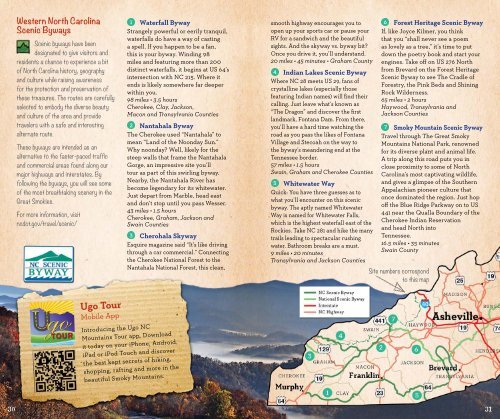
Western <strong>North</strong> CarolinaScenic BywaysScenic byways have beendesignated to give visitors andresidents a chance to experience a bitof <strong>North</strong> Carolina history, geographyand culture while raising awarenessfor the protection and preservation ofthese treasures. The routes are carefullyselected to embody the diverse beautyand culture of the area and providetravelers with a safe and interestingalternate route.These byways are intended as analternative to the faster-paced trafficand commercial areas found along <strong>our</strong>major highways and interstates. Byfollowing the byways, you will see someof the most breathtaking scenery in the<strong>Great</strong> Smokies.For more information, visitncdot.gov/travel/scenic/1 Waterfall BywayStrangely powerful or eerily tranquil,waterfalls do have a way of castinga spell. If you happen to be a fan,this is y<strong>our</strong> byway. Winding 98miles and featuring more than 200distinct waterfalls, it begins at US 64’sintersection with NC 215. Where itends is likely somewhere far deeperwithin you.98 miles • 3.5 h<strong>our</strong>sCherokee, Clay, Jackson,Macon and Transylvania Counties2 Nantahala BywayThe Cherokee used “Nantahala” tomean “Land of the Noonday Sun.”Why noonday? Well, likely for thesteep walls that frame the NantahalaGorge, an impressive site you’llt<strong>our</strong> as part of this swirling byway.Nearby, the Nantahala River hasbecome legendary for its whitewater.Just depart from Marble, head eastand don’t stop until you pass Wesser.43 miles • 1.5 h<strong>our</strong>sCherokee, Graham, Jackson andSwain Counties3 Cherohala SkywayEsquire magazine said “It’s like drivingthrough a car commercial.” Connectingthe Cherokee National Forest to theNantahala National Forest, this clean,smooth highway enc<strong>our</strong>ages you toopen up y<strong>our</strong> sports car or pause y<strong>our</strong>RV for a sandwich and the beautifulsights. And the skyway vs. byway bit?Once you drive it, you’ll understand.20 miles • 45 minutes • Graham County4 Indian Lakes Scenic BywayWhere NC 28 meets US 29, fans ofcrystalline lakes (especially thosefeaturing Indian names) will find theircalling. Just leave what’s known as“The Dragon” and discover the firstlandmark, Fontana Dam. From there,you’ll have a hard time watching theroad as you pass the likes of FontanaVillage and Stecoah on the way tothe byway’s meandering end at theTennessee border.57 miles • 1.5 h<strong>our</strong>sSwain, Graham and Cherokee Counties5 Whitewater WayQuick: You have three guesses as towhat you’ll encounter on this scenicbyway. The aptly named WhitewaterWay is named for Whitewater Falls,which is the highest waterfall east of theRockies. Take NC 281 and hike the manytrails leading to spectacular rushingwater. Bathroom breaks are a must.9 miles • 20 minutesTransylvania and Jackson Counties6 Forest Heritage Scenic BywayIf, like Joyce Kilmer, you thinkthat you “shall never see a poemas lovely as a tree,” it’s time to putdown the poetry book and start y<strong>our</strong>engines. Take off on US 276 <strong>North</strong>from Brevard on the Forest HeritageScenic Byway to see The Cradle ofForestry, the Pink Beds and ShiningRock Wilderness.65 miles • 2 h<strong>our</strong>sHaywood, Transylvania andJackson Counties7 <strong>Smoky</strong> Mountain Scenic BywayTravel through The <strong>Great</strong> <strong>Smoky</strong><strong>Mountains</strong> National Park, renownedfor its diverse plant and animal life.A trip along this road puts you inclose proximity to some of <strong>North</strong>Carolina’s most captivating wildlife,and gives a glimpse of the SouthernAppalachian pioneer culture thatonce dominated the region. Just hopoff the Blue Ridge Parkway on to US441 near the Qualla Boundary of theCherokee Indian Reservationand head <strong>North</strong> intoTennessee.16.5 miles • 35 minutesSwain CountySite numbers correspondto this mapUgo T<strong>our</strong>Mobile AppIntroducing the Ugo NC<strong>Mountains</strong> T<strong>our</strong> app. <strong>Download</strong>it today on y<strong>our</strong> iPhone, Android,iPad or iPod Touch and discoverthe best kept secrets of hiking,shopping, rafting and more in thebeautiful <strong>Smoky</strong> <strong>Mountains</strong>.3031