River Boyne Water Quality Management Plan - EPA
River Boyne Water Quality Management Plan - EPA
River Boyne Water Quality Management Plan - EPA

You also want an ePaper? Increase the reach of your titles
YUMPU automatically turns print PDFs into web optimized ePapers that Google loves.
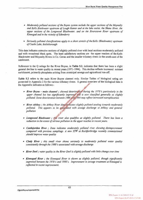
Rivrr Boynr Walcr Qualiiy <strong>Management</strong> <strong>Plan</strong>Moderately polluted sections of the <strong>Boyne</strong> systenl include the upper sections of the Moynalyand Kells Blackwater zpstreanl ojLough Ramor and at the lake outlet, the Skane <strong>River</strong>, theupper sections of the Longwood Blackwater, and on the <strong>River</strong>stown <strong>River</strong> upstreatn ofKinnegad and in the vicinity ofEdendertySeriously polhrted c1assi;fications apply to a short stretch of theKells (Blackwater) zpstreatnof Castle Lake, BailieboroughThis data indicates extensive sections of slightly polluted river with local sections moderately pollutedand with occasional black spots. The least satisfactory sections are the upper reaches of theKellsBlackwater and Moynalty <strong>River</strong>s in Co. Cavan and the smaller tributaly rivers in the south-east of thecatchment.Reference to the Q ratings for the <strong>River</strong> <strong>Boyne</strong>, in Table 5.2, indicates that there has been a slightgeneral decline in water quality in recent years (1971-1994). This decline reflects increased nutrientenrichment, primarily phosphates arising from municipal sewage and agricultural run-off.Table 5.2 refers to the main <strong>River</strong> <strong>Boyne</strong> channel only. Similar Tables of biological rating arepresented in Appendix 2 for the various tributary rivers. A general overview of the biological data inthe Appendix indicates as follows:- ++<strong>River</strong> <strong>Boyne</strong> - main clrannel ; showed deterior&dring the 19705 porticularly in theupper channel but has significantly imnprove&;(i) is now classwed generally as slightlypolluted. Some deterioratiott between 1986 @?4&94 may reflect iltcreosed eutrophicationq . ~b.,.$ .'-G'<strong>River</strong> Atlrboy ; the Athbo-v <strong>River</strong> dat&%&'Eates slighr[vpolI~~ted tetzditig towards nzoder~telypolluted. This appears to be qSs$$'ted with sewage discharge at Atltboy orid general.\Ipollution\S'-+CLongwood Blackwoter ; t@3~uriver also qualifies as slightly pollrrted. There hos been areductiott in the extent ofseriouspoll~ttio~t in the upper reaches in recentyears.Cdlejordan <strong>River</strong> ; Data indicates moderately polluted river showing disimprovetnentcompared with previous samplings. A new SW at Rochfortbridge recently commissionedshould improve water qualityChdy <strong>River</strong> ; this small river shows seriously to nloderately polluted water qzralivconsistently through the 1980 'S associated with sewage discharge<strong>River</strong>DeeI; water quality hi the <strong>River</strong> Deel is slightlypoll~rted with little change over timeKinnegad <strong>River</strong> ; the Kinnegad <strong>River</strong> is shown as slightly polluted, though significantlyimproved between the 1970's mid 1990 's. Itnprovetne~~t in sewage treatntent at Kitznegad isreflected in recent itnproven~eltt.,vFor inspection purposes only.Consent of copyright owner required for any other use.<strong>EPA</strong> Export 26-07-2013:17:27:00