1. Roman Roads and Milestones - British Institute at Ankara
1. Roman Roads and Milestones - British Institute at Ankara
1. Roman Roads and Milestones - British Institute at Ankara

You also want an ePaper? Increase the reach of your titles
YUMPU automatically turns print PDFs into web optimized ePapers that Google loves.
CONTENTS<strong>1.</strong> ACKNOWLEDGEMENTS . . . . . . . . . . . 32. BIBLIOGRAPHY . . . . . . . . . . . . . 42.1 Abbrevi<strong>at</strong>ions . . . . . . . . . . 42.2 Bibliography . . . . . . . . . . . 43. NOTES AND COMMENTS . . . . . . . . . . . 73.1 The Text of Republican <strong>Milestones</strong> . . . . . . . 73.2 The Context of Republican <strong>Milestones</strong> . . . . . . 83.3 Distance Figures on Republican <strong>Milestones</strong> . . . . . 93.4 A Road between Pergamum <strong>and</strong> the Hebrus? . . . . . 123.5 Manlius Vulso in Thrace, 188 BC, <strong>and</strong> the route from Callipolisto the Hebrus . 194. MILESTONES . . . . . . . . . . . . . 274.1 Numbered <strong>Milestones</strong> . . . . . . . . . 284.2 Design<strong>at</strong>ed <strong>Roads</strong> <strong>and</strong> Numbered <strong>Milestones</strong> . . . . . 284.3 Epigraphic Conventions . . . . . . . . . 294.4 Texts . . . . . . . . . . . . 305. ILLUSTRATIONS: MAPS . . . . . . . . . . . 435.1 Republican <strong>Roads</strong> in Asia Minor . . . . . . . 455.2 Gelibolu to the Meriç (based on Turkish 1:500,000) . . . . 465.3 Gelibolu to the Meriç (based on Turkish 1:200,000) . . . . 476. ILLUSTRATIONS: FIGURES . . . . . . . . . . . 486.1 Published Facsimiles . . . . . . . . . 496.2 Drawings from Squeezes . . . . . . . . . 537. ILLUSTRATIONS: PLATES . . . . . . . . . . . 567.1 <strong>Milestones</strong> . . . . . . . . . . . 567.2 Squeezes . . . . . . . . . . . 61
RRMAM Vol. 3 <strong>Milestones</strong>: David French<strong>1.</strong> ACKNOWLEDGEMENTSI wish to acknowledge here the expertise, advice <strong>and</strong> criticism given by Stephen Mitchell <strong>and</strong>Michael Crawford <strong>and</strong> to thank, for their help, all those who assisted in the prepar<strong>at</strong>ion of thisdigital version, especially Abby Robinson, Research Scholar <strong>at</strong> the <strong>British</strong> <strong>Institute</strong> of Archaeology<strong>at</strong> <strong>Ankara</strong>, <strong>and</strong> to Michele Massa, Research Fellow <strong>at</strong> the <strong>British</strong> <strong>Institute</strong> of Archaeology <strong>at</strong><strong>Ankara</strong>. To the Director, Lutgarde V<strong>and</strong>erput, I am indebted for her support <strong>and</strong> encouragement,<strong>and</strong> to Andrew Peacock, Chairman of the <strong>Institute</strong>’s Public<strong>at</strong>ion Committee, for his assistance in thesetting-up of on-line public<strong>at</strong>ion.3 © <strong>British</strong> <strong>Institute</strong> <strong>at</strong> <strong>Ankara</strong>
RRMAM Vol. 3 <strong>Milestones</strong>: David French2. BIBLIOGRAPHY2.1 Abbrevi<strong>at</strong>ionsThe abbrevi<strong>at</strong>ions primarily employed here for journals <strong>and</strong> periodicals are listed in L'AnnéePhilologique, “Index of Articles”; they are supplemented, where necessary, by AJA 90 (1986), 384-394 “Abbrevi<strong>at</strong>ions for Periodicals <strong>and</strong> (2) for Individual Works” <strong>and</strong> AJA 104 (2000), 10-24, <strong>and</strong>by Zeitschriftenverzeichnis nach Abkürzungen, JdI Archäologische BibliographieThe following abbrevi<strong>at</strong>ions are not generally found in current lists:AST Araştırma Sonuçları ToplantısıBdI Bullettino dell’Istituto di Corrispondenza ArcheologicaΜκΒ Μουσεῖον καὶ Βιβλιοθήκη τῆς Εὐαγγελικῆς Σχολῆς τῆς Σμύρνης2.2 BibliographyBakalakis, G.– 1961 Αρχαιολογικές έρευνες στη Θράκη. ThessalonikeBean, G. E.– 1959 Notes <strong>and</strong> Inscriptions from Pisidia, part <strong>1.</strong> An<strong>at</strong>St 9, 67-117Broughton, T. R. S.– 1986 The Magistr<strong>at</strong>es of the <strong>Roman</strong> Republic 3. Supplement. AtlantaCavedoni, C.– 1846 Iscrizioni bilingui del Corpus inscriptionum Graecarum. BdI, 185-188Collart, P.– 1976 Les miliaires de la Via Egn<strong>at</strong>ia. BCH 100, 177-200Cottier, M., Crawford, M. H., Crowther, C. V., Ferrary, J.-L., Levick, B. M., Salomies, O. <strong>and</strong>Wörrle, M.– 2008 The Customs Law of Asia. OxfordCrawford, M. H.– 1996 (ed.) <strong>Roman</strong> st<strong>at</strong>utes 1, 2. London (Bull. Inst. Class. Stud. Suppl. 64)Curtius, E.– 1872 Beiträge zur Geschichte und Topographie Kleinasiens (Ephesos, Pergamon, Smyrna,Sardes). In Verbindung mit den Herrn Major Regely, Baur<strong>at</strong>h Adler, Dr Hirschfeld undDr Gelzer. Abh. phil.-hist. Kl. Kgl. Akad. d. Wiss. 1872 no. 1, 1-91 <strong>and</strong> Pls 1-5. BerlinEgmond, J. A. van <strong>and</strong> Heyman, J.– 1757-58 Reizen door gedeelte van Europa, Kleinasien etc. 1-2. LeidenEngelmann, H. <strong>and</strong> Knibbe, D.– 1989 Das Zollgesetz von Asia. Eine neue Inschrift aus Ephesos. EpigrAn<strong>at</strong> 14Fasolo, M.– 2005 La Via Egn<strong>at</strong>ia I. Da Apollonia e Dyrrachium ad Heraclia Lyncestidos. RomeFontrier, A.– 1880 Communic<strong>at</strong>ion. BCH 4, 495French, D. H.– 1980 The <strong>Roman</strong> Road System of Asia Minor. In Temporini, H. <strong>and</strong> Haase, W. eds, ANRW2.7.2, 698-729. Berlin– 1984b Roma Yolları ve Miltaşları 1983. AST 2, 123-129– 1991b Sites <strong>and</strong> Inscriptions Phrygia, Pisidia <strong>and</strong> Pamphylia. EpigrAn<strong>at</strong> 17, 51-68 <strong>and</strong> Pls 6-11– 1995b <strong>Milestones</strong> from the Izmir Region. EpigrAn<strong>at</strong> 25, 95-102 <strong>and</strong> Pl. 20– 1997 Pre- <strong>and</strong> Early-<strong>Roman</strong> <strong>Roads</strong> of Asia Minor: The Earliest <strong>Roman</strong> paved <strong>Roads</strong> in Asia4 © <strong>British</strong> <strong>Institute</strong> <strong>at</strong> <strong>Ankara</strong>
RRMAM Vol. 3 <strong>Milestones</strong>: David FrenchMinor. Arkeoloji Dergisi 5, 179-187Garrucci, R.– 1875-77 Sylloge inscriptionum l<strong>at</strong>inarum aevi romanae reipublicae usque ad C. IuliumCaesarem plenissima. TurinHassall, M., Crawford, M. H. <strong>and</strong> Reynolds, J.– 1974 Rome <strong>and</strong> the eastern provinces <strong>at</strong> the end of the second century BC. JRS 64, 195-220Haussoullier, B.– 1899 Un nouveau milliaire au nom de Manius Aquillius. RPhil 23, 293-299Isaac, B.– 1986 The Greek settlements in Thrace until the Macedonian conquest. LeidenKahrstedt, U.– 1954 Beiträge zur Geschichte der thrakischen Chersones. Baden-BadenKallet-Marx, R. M.– 1995 Hegemony <strong>and</strong> Empire: the development of <strong>Roman</strong> IMPERIUM in the East from 148to 62 BC. Berkeley <strong>and</strong> OxfordKern, O.– 1900 Die Inschriften von Magnesia am Mae<strong>and</strong>er. BerlinKülzer, A.– 2008 Tabula Imperii Byzantini 12. Ostthrakien (Eurōpē). WienLoukopoulou, L. D.– 1987 Provinciae Macedoniae finis orientalis: The establishment of the eastern frontier.In H<strong>at</strong>zopoulos, M. B. <strong>and</strong> Loukopoulou, L. D., Two studies in ancient Macedoniantopography, 61-100. Athens (Meletem<strong>at</strong>a 3)Magie, D.– 1950 <strong>Roman</strong> Rule in Asia Minor 1, 2. PrincetonMitchell, S.– 1999 The Administr<strong>at</strong>ion of <strong>Roman</strong> Asia from 133 BC to AD 250. In Eck, W. (ed.), LokaleAutonomie und römische Ordnungsmacht in der kaiserzeitlichen Provinzen vom <strong>1.</strong> bis 3Jahrhundert, 17-46 (Schr. des Hist. Kollegs Kolloquien 42)– 2008 Geography, Politics <strong>and</strong> Imperialism in the Asia Customs Law. In Cottier et al. (eds) 2008,165-201Mommsen, Th.– 1884a Additamenta tertia ad Corporis vol. III. EphEp 5, 1-104– 1884b Auctarium additamentorum ad Corporis vol. III. EphEp 5, 569-624Mottas, Fr.– 1989 Les voies de communic<strong>at</strong>ion antiques de la Thrace égéenne. In Herzig, H. F. <strong>and</strong> Frei-Stolba, R. (eds), Labor omnibus unus. Gerold Walser zum 70. Geburtstag, 82-104. Stuttgart(Historia Einzelschr. 60)Papazoglou, F.– 1979 Quelques aspects de l’histoire de la province Macédoine. In Temporini, H. (ed.) ANRW2, 7, 1, 302-369Pekary, Th.– 1968 Untersuchungen zu den römischen Reichstraßen. Bonn (Antiquitas <strong>1.</strong>17)Pottier, E. <strong>and</strong> Besnault, Am. Hauvette– 1880 Inscriptions d’Asie Mineure. BCH 4, 375-382Ramsay, W. M.– 1881 Contributions to the history of Southern Aeolis. Pt <strong>1.</strong> JHS 2, 44-54– 1887 Antiquities of Southern Phrygia <strong>and</strong> the border l<strong>and</strong>s <strong>1.</strong> AJA 3, 344-368– 1895-97 The Cities <strong>and</strong> Bishoprics of Phrygia 1, 1-2. Oxford5 © <strong>British</strong> <strong>Institute</strong> <strong>at</strong> <strong>Ankara</strong>
RRMAM Vol. 3 <strong>Milestones</strong>: David FrenchSayar, M. H– 1998 Doğu Trakya’da epigrafi ve tarih-coğrafya araştırmaları 1996. AST 15, 323-330– 1999 Pergamon und Thrakien. Ein Beitrag zur Geschichte Thrakiens in der hellenistischen Zeitanh<strong>and</strong> von Ehreninschriften aus Bisanthe für Eumenes II., Attalos II und Str<strong>at</strong>onike. InScherrer, P., Taeuber, H. und Thür, H. (eds), Steine und Wege. Festschrift für Dieter Knibbezum 65. Geburtstag, 245-25<strong>1.</strong> Vienna (Sonderschr. 32)– 2000 Doğu Trakya’da epigrafi ve tarih-coğrafya araştırmaları 1999. AST 18, 1, 289-300– 2001 Doğu Trakya’da epigrafi ve tarih-coğrafya araştırmaları 2000. AST 19, 2, 99-110– 2004 Doğu Trakya’da yüzey araştırmaları 2003. AST 22, 2, 229-230 <strong>and</strong> Figs 1-9– 2007 Doğu Trakya’da yüzey araştırmaları 2006. AST 25, 2, 269-271, Maps 1-3 <strong>and</strong> Figs 1-9– 2011 The Via Egn<strong>at</strong>ia on Eastern Thrace. In Via Egn<strong>at</strong>ia Found<strong>at</strong>ion (ed.), Via Egn<strong>at</strong>iaRevisited: Common past, common future, Proceedings VEF Conference, Bitola, February2009, 43-44Soustal, P.– 1991 Tabula Imperii Byzantini 6. Thrakien. WienTafel, T. L. F.– 1842 De via militari romanorum Egn<strong>at</strong>ia qua Illyricum, Macedonia et Thracia iungebantur.Tübingen (repr. London 1972)Walbank, F. W.– 1983 Via illa nostra militaris. Some thoughts on the Via Egn<strong>at</strong>ia. In Heinen, H. (ed.),Althistorische Studien, 131-147. Wiesbaden (HistEinz-schr. 40)– 1985 The Via Egn<strong>at</strong>ia: its original scope <strong>and</strong> d<strong>at</strong>e. In Danov, Khr. M. <strong>and</strong> Tacheva, M. (eds),Studia in honorem Christo M. Danov, 458-464. Sofia (Terra Antiqua Balcanica 2)– 2005 The Via Egn<strong>at</strong>ia: its role in <strong>Roman</strong> str<strong>at</strong>egy. In Fasolo, M. 2005, i-ixWarmington, E. H.– 1940 Remains of Old L<strong>at</strong>in 4. London <strong>and</strong> Cambridge (Loeb ed.)6 © <strong>British</strong> <strong>Institute</strong> <strong>at</strong> <strong>Ankara</strong>
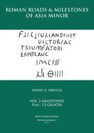
RRMAM Vol. 3 <strong>Milestones</strong>: David French3. NOTES AND COMMENTS3.1 The Text of Republican <strong>Milestones</strong>The Çamlık inscription (below, no. 5) provides the st<strong>and</strong>ard text for those milestones which wereerected by Manius Aquillius during his proconsulship, 129-126 BC. In the text – here design<strong>at</strong>ed asthe “st<strong>and</strong>ard” for Manius Aquillius – on the Çamlık milestone, the word υἱός is omitted. Theextended form of Manius Aquillius’ p<strong>at</strong>ronymic – Μανίου υἱός – is found only on the milestonesof L. Aquillius Florus, <strong>at</strong> Sağlık (below, no. 1) <strong>and</strong> <strong>at</strong> Tire (below, no. 4), but not on the milestoneof L. Aquillius Florus <strong>at</strong> Aydın (below, no. 6. Aydın 1).There is a close - but not exact - similarity, in form <strong>and</strong> text, between the milestones of Asia <strong>and</strong>Macedonia, cp. the Çamlık text (below, no. 5) with the text of the Gallikos <strong>and</strong> Amygdaleonasmilestones (AE 1976. 643 <strong>and</strong> SEG 40. 543, respectively). One notable distinction between theMacedonian <strong>and</strong> Asian milestones is the title of the governor: cos (for consul) on the Asian, procos(for proconsul) on the Macedonian milestones.Note the simultaneous use of a straight-bar A (in the L<strong>at</strong>in text) <strong>and</strong> a broken-bar alpha (in theGreek text) on all the milestones.Note also the ambiguity of the word restituit, preserved <strong>at</strong> Sağlık (below, no. 1) <strong>and</strong> <strong>at</strong> Tire (below,no. 4), restored <strong>at</strong> Aydın (below, no. 6, Aydın 1): does the term apply to the road or to themilestone? (cp. Pekary 1968, 69). The sense of this verb is not always clear. In the case of Sağlık,Tire <strong>and</strong> Aydın, I have proposed (1995, 101) th<strong>at</strong> the term refers to a restor<strong>at</strong>ion (<strong>and</strong> re-wording) ofthe original, Aquilan milestones after their destruction during the Mithrid<strong>at</strong>ic wars. For a suggestion th<strong>at</strong> the Republican roads on the Attalid territory of Asia Minor (<strong>and</strong> Thrace)were not paved but only “trackways” (regularly maintained, passable by vehicles <strong>and</strong> administeredby the <strong>Roman</strong> authorities), converted from older “trackways”, see an earlier discussion (French1997, with texts <strong>and</strong> references). The first paved roads were constructed by Augustus (viam fecit):the Via Sebaste (from Perge to Colonia Lystra) in 6 BC <strong>and</strong>, in Asia, an unnamed road N ofEphesus.7 © <strong>British</strong> <strong>Institute</strong> <strong>at</strong> <strong>Ankara</strong>
RRMAM Vol. 3 <strong>Milestones</strong>: David French3.2 The Context of Republican <strong>Milestones</strong>On the evidence of the Side milestone, it is clear th<strong>at</strong> Aquillius was adopting <strong>and</strong> affirming anexisting road-network within the boundaries inherited from the Attalid kingdom, perhaps for civilpurposes, possibly also for military reasons. Wh<strong>at</strong>ever the purpose, the establishment of an officialroad net-work should be understood as an assertion – symbolized by the very massiveness of theroad-markers – of <strong>Roman</strong> territorial possession in Asia Minor (French 1991, 53-54).There is the strongest possibility th<strong>at</strong> (as yet) undiscovered Republican milestones will indic<strong>at</strong>e notsimply an addition to our synopsis of roads in Republican Asia but also indirectly the destin<strong>at</strong>ion ofa road, e.g. Apamea, Synnada or Philomelium, although the city itself may not be named, as in thecase of Side (text no. 10). Such milestones will thus demonstr<strong>at</strong>e Manius Aquillius’ organiz<strong>at</strong>ion ofa road-network within the eastern territories of the former Attalid kingdom (roughly speaking, theregion bounded by Dorylaeum, Philomelium, Synnada, Apamea, Amblada <strong>and</strong> Side) <strong>and</strong> therebythe full reach of his administr<strong>at</strong>ive authority in th<strong>at</strong> region. For notes on the discreet group (of milestones) formed by the three examples, (no. 6) Aydın 1,(no. 1) Sağlık <strong>and</strong> (no. 4) Tire, <strong>and</strong> for observ<strong>at</strong>ions on their historical context (post-Mithrid<strong>at</strong>icrestor<strong>at</strong>ion of the milestones) <strong>and</strong> d<strong>at</strong>e (c. 70 BC), see French (1995, 100-101). For the unity of the Aydın text, cp. the remarks on the Sağlık <strong>and</strong> Tire milestones (French 1995,100 “the inscription was cut by L. Aquillius Florus as a single whole, . . . . not in two halves, eachinscribed <strong>at</strong> a different period, . . . . it is not to be divided on the assumption th<strong>at</strong> the second half[which names L. Aquillius Florus] was added, <strong>at</strong> a l<strong>at</strong>er d<strong>at</strong>e, to an earlier text [which recorded onlyManius Aquillius]”). It is significant – in my view – th<strong>at</strong> the letter-sizes between the upper (lines1-5) <strong>and</strong> lower (lines 6-11) halves of the Sağlık text are observably uniform, c. 0.022, <strong>and</strong> are muchless massive than the letters on the “st<strong>and</strong>ard” text, Çamlık (below, no. 5), c. 0.060. For the historical context of the Side milestone, <strong>and</strong> of the Sağlık, Tire <strong>and</strong> Aydın 1 milestones,see Mitchell (1999, 19-20).8 © <strong>British</strong> <strong>Institute</strong> <strong>at</strong> <strong>Ankara</strong>
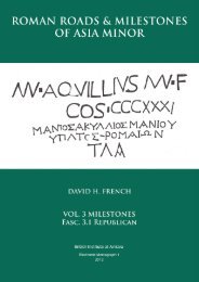
RRMAM Vol. 3 <strong>Milestones</strong>: David French3.3.1 Distance Figures on Republican <strong>Milestones</strong>: the Çamlık milestoneOn present knowledge there were two major points from which, in the newly-inherited kingdom ofAttalus III, the road-distances on Republican milestones were measured: Ephesus <strong>and</strong> Pergamum.Neither city was named in the text of an existing milestone. Thus, no caput viae was indic<strong>at</strong>ed forthe road on which a milestone was erected. As on very many milestones of the Imperial period thedistance-figure was, no doubt, readily understood without the need for a specific indic<strong>at</strong>ion (usuallyin the form: “From + City-name”, as in “Ab Epheso”).The figure V on the Çamlık milestone is manifestly the distance from Ephesus. The moderndistance from Efes to the Çamlık st<strong>at</strong>ion is c. 8 km (= 5 MP). The caput viae, therefore, though notnamed, is clearly Ephesus. The stone may well have been in situ when it was discovered during theconstruction of the İzmir - Aydın railway.3.3.2 Distance Figures on Republican <strong>Milestones</strong>: the Dikili milestoneA second milestone was also measured from Ephesus: Dikili near Pergamum (see below, no. 3,distance-figure CXXXI). Less clear is the original position of this stone (now lost). The orthodoxinterpret<strong>at</strong>ion (Dessau s. ILS <strong>1.</strong> 27) puts the Dikili milestone on the Ephesus - Pergamum road.There are three possibilities for the original loc<strong>at</strong>ion of the stone.(1) If Pergamum was by-passed by the road from Ephesus, the distance-figure – CXXXI (= 194.5km) on the Dikili text would place the milestone <strong>at</strong> Altınova, according to my calcul<strong>at</strong>ions, i.e. c.22.5 km beyond Dikili, in the direction of Edremit (ancient Adramyttium).(2) The same figure, CXXXI, if applied to a road leading NE or E (to Cyzicus ?) from Pergamum,would take the stone c. 22.5 km eastwards beyond Bergama <strong>and</strong> correspondingly over 50 km E ofDikili.(3) On the other h<strong>and</strong>, if the road on which the stone was erected ran first to Pergamum <strong>and</strong> thenNW towards Dikili <strong>and</strong> Altınova (as the modern road), the distance-figure would correspond almostexactly to the modern distance (c. 193 km) from Efes to Bergama <strong>and</strong> thence to the neighbourhoodof Dikili. The modern loc<strong>at</strong>ion, therefore, of the milestone <strong>at</strong> Dikili would not be far from anoriginal, ancient position on a road running northwards from Pergamum towards Adrymyttium.If possibility (3) is correct (as I believe), Pergamum was simply an (unnamed) intermediary, not acaput viae, on the road N from Ephesus to Lampsacus (see below, section 3.3.3). The road wasthus measured from Ephesus alone, without regard for intervening cities, cp. Kazıkbağları 1 underVespasianus, MP LXXXVIII from Ephesus. The same practice – a single caput viae – was adoptedfor the road from Pergamum to Side (see below).3.3.3 Distance Figures on Republican <strong>Milestones</strong>: the Kazıkbağları 3 <strong>and</strong> Tire milestonesOn the basis of the low numeral, it is plausible th<strong>at</strong> one milestone – Kazıkbağları 3 – was measuredfrom Pergamum, though found S of the site of Elaea (c. 500 m W of the modern highway belowZeytindağ, in the area called Kazıkbağları). Elaea lies c. 25 km SW of Pergamum. The distancefigureon the Kazıkbağları 3 milestone is III. If milestones on the Ephesus - Pergamum road wereall measured from Ephesus, the distance-figure III would suggest th<strong>at</strong> the Kazıkbağları 3 stone wasan anomaly. If it had not been erected on the road between Ephesus <strong>and</strong> Pergamum, it musttherefore belong to another road. I suggest three possibilities:(1) the stone was carried from a road which, measured from Pergamum, ran eastwards (as does theSide road, q.v. below, section 3.3.4),9 © <strong>British</strong> <strong>Institute</strong> <strong>at</strong> <strong>Ankara</strong>
RRMAM Vol. 3 <strong>Milestones</strong>: David French(2) the stone was carried from a road which, measured from Pergamum, ran N to Lampsacus (seebelow, section 3.4) or(3) the stone may not have been carried c. 25 km southwards from Bergama but rel<strong>at</strong>es to a road <strong>at</strong>Elaea itself, i.e. it was measured from the Ephesus - Pergamum road to the city <strong>and</strong> port.A similar uncertainty is <strong>at</strong>tached to the milestone from Tire. The distance figure on this stone,XXIIII (= 35.64 km), is certainly measured from Ephesus, but along which road? Tire itself lies 41km NE from Efes, on a road to Sardis. If the stone was erected on the Ephesus - Lampsacus(?)road, its original loc<strong>at</strong>ion would fall c. 10.5 km N of Torbalı, <strong>at</strong> a point c. 45 km W of Tire.3.3.4 Distance Figures on Republican <strong>Milestones</strong>: the Side milestoneNot immedi<strong>at</strong>ely obvious is the caput viae of the Side milestone: Ephesus or Pergamum?Note the change in Ramsay’s interpret<strong>at</strong>ion of the distance-figure on a milestone found <strong>at</strong> Yarașlı in1884 on the road running towards Perge (<strong>and</strong>, as we now know, to Side). He himself <strong>at</strong> first (1887,366) suggested Pergamum as the caput viae of the Yarașlı 1 stone, l<strong>at</strong>er (1895-97, 1, 330-331)Ephesus (cp. the commentary on the Yarașlı 1 stone, below, no. 9[A]). Ramsay’s second view (cp.French 1980, 727) persisted until the recording of the Side milestone in 1990. Ramsay (1895-97, 1,331) calcul<strong>at</strong>ed 223 MP for a route from Ephesus to Yarașlı “around by Apameia”.The figure preserved on the milestone found near Side is interpreted (here <strong>and</strong> previously [French1991b, 53]) as the distance from Pergamum. On the Side stone, as on all other Republicanmilestones, the caput viae is not named.The route of the Republican road from Pergamum to Side can be reconstructed as follows:Bergama – Kınık – Marmaragöl (W side) – Sart (ancient Sardis) – Alașehir (anc. Philadephia)– Dindarlı – Yenice – Çeșmebașı – Pamukkale (anc. Hierapolis) – Eskihisar (anc. Laodiciaad Lycum) – Honaz (anc. Colossae)– Kaklık – Bașçeșme – Bozkurt – Çaltı – Dereköy –Yarașlı (anc. Takina) (milestones) – Karacabel – Boğaziçi – Elmacık – Dütmenkocadüzü –Aziziye (plain of) – Pazarçam – Kızılalan Deresi – Ürkütlü - Șerefdede Hüyük (anc.Comama) – Kızılkaya – Bademağacı (plain of) – İstunas Çiftliği – Döșeme Boğazı – Dereli –Aksu (anc. Perga) – Köprü Irmağı (anc. River Eurymedon) (bridge) – Kumköy, Kızlık Dere(milestone) – SideThe distances on this route can be measured, to a certain level of accuracy, from the Turkish1:200,000 maps:Bergama to Yarașlı 329 km = 22<strong>1.</strong>5Yarașlı to Side 166 km = 11<strong>1.</strong>5495 km = 333.0 MP (1 MP = <strong>1.</strong>485 km)The distance-figure on the Side milestone (found c. 5 km [= 3+ MP] W of the town): 331 MP (=49<strong>1.</strong>5 km).The altern<strong>at</strong>ive route, beginning from Ephesus, would run through Tralles (modern Aydın):Efes – Çamlık (milestone) – Germencik – Aydın (anc. Tralles) – Nazilli (anc. Nysa) –Sarayköy – Eskihisar (anc. Laodicia ad Lycum) <strong>and</strong> thence as above to Side10 © <strong>British</strong> <strong>Institute</strong> <strong>at</strong> <strong>Ankara</strong>
RRMAM Vol. 3 <strong>Milestones</strong>: David FrenchThis route too can be measured with some accuracy:Efes to Yarașlı 257Yarașlı to Side 166422 km = 284 MP (1 MP = <strong>1.</strong>485 km)It is apparent th<strong>at</strong> the distance, Ephesus to Side through Tralles, falls short of the kilometreequivalent (331 MP = 49<strong>1.</strong>5 km) of the mile-figure on the Side stone.I have concluded, therefore, th<strong>at</strong> the caput viae of the Side milestone was Pergamum, not Ephesus.Ramsay’s first opinion is thus confirmed <strong>and</strong> his second is rejected.11 © <strong>British</strong> <strong>Institute</strong> <strong>at</strong> <strong>Ankara</strong>
RRMAM Vol. 3 <strong>Milestones</strong>: David French3.4 A Road between Pergamum <strong>and</strong> the Hebrus?with Map 5.1Two hypotheses for the establishment of a road from Pergamum through Thrace to the Hebrus arehere proposed.It is argued above (section 3.3.2), <strong>and</strong> plausibly demonstrable, th<strong>at</strong> the Dikili stone was erected on aroad leading N from Pergamum. I propose here th<strong>at</strong> from Pergamum the road ran northwards toAdramyttium, thereafter to a crossing (traiectus) of the Hellespont – <strong>at</strong>tested both in the 2nd <strong>and</strong> 1stcenturies BC <strong>and</strong> in the Imperial period – between Lampsacus <strong>and</strong> Callipolis, <strong>and</strong> from Callipolisonwards through the Thracian Chersonese to the River Hebrus, the destin<strong>at</strong>ion or terminus of theVia Egn<strong>at</strong>ia in Macedonia, thereby completing a l<strong>and</strong> link of military st<strong>at</strong>us <strong>and</strong> function betweenthe two provinces, Asia <strong>and</strong> Macedonia (see Map 5.1), <strong>and</strong> ultim<strong>at</strong>ely Italy.Almost immedi<strong>at</strong>ely after the inheritance of the Attalid kingdom in 133 BC <strong>and</strong> the subsequentconversion of the Hellenistic kingdom into a <strong>Roman</strong> province, a formal road – a “roadway” (anunpaved, vehicular road – was established through Thrace as far as the Hebrus. This work wascarried out, I suggest, by Manius Aquillius, proconsul in Asia 129-126 BC, as a complement to thework of Cn. Egn<strong>at</strong>ius, proconsul in Macedonia. It is not necessary to postul<strong>at</strong>e th<strong>at</strong> Aquillius built a“highway” (a paved, vehicular road), in other words, th<strong>at</strong> he was necessarily responsible for thebuilding of a paved road, the terms for which are viam munivit or viam stravit or, simply, viam fecit.The second hypothesis essentially interprets the function of the two roads, namely, th<strong>at</strong> theconstruction of a military road through Macedonia to the Hebrus, <strong>and</strong> thence through Thrace to theHellespont <strong>and</strong> so into Asia, had a str<strong>at</strong>egic purpose: the establishment of a l<strong>and</strong>-route from theAdri<strong>at</strong>ic to the newly acquired territories in Asia Minor. Th<strong>at</strong> the construction was the result of aco-ordin<strong>at</strong>ed oper<strong>at</strong>ion is a proposition which is not easy to sustain. Egn<strong>at</strong>ius in Macedonia mustnecessarily be a contemporary of Aquillius in Asia. In other words, Egn<strong>at</strong>ius’ activities which ledto the cre<strong>at</strong>ion of a road <strong>and</strong> the erection of milestones (bearing his name) along th<strong>at</strong> road cannotlogically be earlier than similar activities of Manius Aquillius in Thrace. The crux of theproposition is the d<strong>at</strong>e of Cn. Egn<strong>at</strong>ius’ proconsulship in Macedonia.The evidence to test the first hypothesis, however, is almost non-existent.In Asia the epigraphic cupboard is bare. Pertinent literary sources are poor. Apart from the Dikilimilestone, there are no Republican milestones between Pergamum <strong>and</strong> Lampsacus. In Thrace,between Callipolis <strong>and</strong> the Hebrus, there are neither milestones (Republican or, indeed, Imperial) tosupport this hypothesis, nor any direct, archaeological evidence for a road from the Hellespont tothe Hebrus. No one, to my knowledge, has found – or indeed sought – a road across the Kurudağ,the range between the Thracian plain N of modern İpsala <strong>and</strong> the Gelibolu peninsula – although anold (if not ancient) vehicular track is clearly marked N of Kadıköy on the Turkish 200,000 map,Çanakkale 7-o. Nor, similarly, has the pass eastwards through the central Kurudağ towardsTekirdağ [ancient Rhaidestos], the Derbent Boğazı [now flooded by a baraj (dam)], been examinedfor evidence of a road from the Hebrus to Heraclia-Perinthus (modern Ereğli) <strong>and</strong> Byzantium, asindic<strong>at</strong>ed in the Itinerarium Antonini 332,1-9 <strong>and</strong> in the Itinerarium Burdigalense 601,6-602,7).The reconstruction (proposed here) of a Republican road through Thrace to the Hebrus is made onthe assumption th<strong>at</strong> all territories which the <strong>Roman</strong>s inherited from Attalus both in Asia <strong>and</strong> inEurope were brought under administr<strong>at</strong>ive control by the formaliz<strong>at</strong>ion of roads (th<strong>at</strong> is to say, theconversion of existing routes to <strong>Roman</strong> control) <strong>and</strong> the erection of milestones, the whole being the12 © <strong>British</strong> <strong>Institute</strong> <strong>at</strong> <strong>Ankara</strong>
RRMAM Vol. 3 <strong>Milestones</strong>: David Frenchwork of the first proconsul, Manius Aquillius. These territories would include Attalici agri inThrace. I suggest th<strong>at</strong> Attalus held l<strong>and</strong>s in the area extending from the Hellespont (<strong>and</strong> theThracian Chersonese proper) northwards to the Kurudağ range (<strong>at</strong> the southern edge of theThracian plain) <strong>and</strong> northwestwards towards the Hebrus; contra Walbank (1983, 145), who st<strong>at</strong>edth<strong>at</strong> Thracian l<strong>and</strong>s – specifically the “Caeneic Chersonese” – lay south of the Kurudağ, Attalus’l<strong>and</strong>s being confined to the Thracian Chersonese itself. By so restricting the extent of Attalidpresence, Walbank dissoci<strong>at</strong>es the narrow neck of the Thracian Chersonese from the broader areaembracing the littoral of the Propontis (where a cluster of Attalid inscriptions have been found) E ofthe Kurudağ <strong>and</strong> the lowl<strong>and</strong>s both S of the Kurudağ <strong>and</strong> W of the Kurudağ towards the Hebrus.Walbank (2005, i) saw the Via Egn<strong>at</strong>ia “ending ultim<strong>at</strong>ely <strong>at</strong> Byzantium with an important branchthrough the Thracian Chersonese to the crossing of the Dardanelles”. The same destin<strong>at</strong>ion –Byzantium – is indic<strong>at</strong>ed on Sayar’s map (1995, 246). In these accounts the essential direction ofthe Via Egn<strong>at</strong>ia from the Hebrus was not to Callipolis (the route of Cicero) but to Byzantium (as theroad [W to E] in the Itinerarium Antonini 332 <strong>and</strong> [E to W] in the Itinerarium Burdigalense 60<strong>1.</strong>6-602.7). Strabo (quoted below) applies the name Via Egn<strong>at</strong>ia only to the road in Macedonia as far asthe Hebrus: Via Egn<strong>at</strong>ia, when applied to the road from the Hebrus to Byzantium, is, therefore, amodern misnomer, cp. Tafel (1842, part 2 <strong>and</strong> map). The region of eastern Thrace did not becomea <strong>Roman</strong> province – capital <strong>at</strong> Perinthus – until the year AD 45/46 under the emperor Claudius.Then or l<strong>at</strong>er, it can be assumed, the extension to Byzantium was added from the existing(Republican) road from the Hebrus to the Hellespont.On the basis of the surviving sources <strong>and</strong> of the (uncertain) identific<strong>at</strong>ion of place-names <strong>at</strong>tested inthose sources, Walbank (1983, 140-146) reconstructed a geography of Thrace between the Hebrus<strong>and</strong> Byzantium in the years before the campaign of T. Didius, praetor of Macedonia, in 101 BC. Inthis reconstruction he confines the agri Attalici to the Thracian Chersonese <strong>and</strong> loc<strong>at</strong>es (1983, 145)the “Caeneic Chersonese” (the area of Didius’ campaign) in the region “N <strong>and</strong> W of the Chersoneseproper, centring on the R. Melas, but extending inl<strong>and</strong> to include the range of hills now called theKurudağ . . . . <strong>and</strong> probably the region around the tributaries of the Ergene as far as Cypsela”.The epigraphic source, however, rel<strong>at</strong>ing to the “Caeneic Chersonese” has been emended (seebelow), allowing a less confined area for the Attalici agri. Consequently, the sources for Thraciangeography <strong>and</strong> the history of <strong>Roman</strong> actions in Thrace in the l<strong>at</strong>e-2nd century BC can now bear analtern<strong>at</strong>ive interpret<strong>at</strong>ion, namely, th<strong>at</strong> the Attalici agri occupied a wider <strong>and</strong> geographically welldefined area which comprised both the Thracian Chersonese proper <strong>and</strong>, on the NE, theimmedi<strong>at</strong>ely neighbouring lowl<strong>and</strong>s lying N of the Kavak Çay (Melas Fl.) as far as the Kurudağchain on the N <strong>and</strong> E <strong>and</strong> the territory of Aenus on the W. This geographically definable areaformed, I suggest, not Walbank’s “regio Caenica” but the essential core of the Attalici agri. This isthe area which was traversed – as successor of a Republican road – by the Hebrus-Callipolis road ofthe Itinerarium Antonini in order to reach the Hellespont crossing. On this interpret<strong>at</strong>ion themilitary campaigns of T. Didius in 101 BC took place N <strong>and</strong> NE of the Kurudağ, the territoryproper of the Caeni (so the Barrington Atlas Map 51), not S of the Kurudağ, here defined as Attalidterritory <strong>and</strong> (after 133 BC) as part of <strong>Roman</strong> territory. The campaign of Didius can, therefore, beinterpreted as a min<strong>at</strong>ory oper<strong>at</strong>ion in order to protect the former Attalid l<strong>and</strong>s, <strong>and</strong> the extension ofthe Via Egn<strong>at</strong>ia to the Hellespont, from barbarian vex<strong>at</strong>ions of the kind which l<strong>at</strong>er, in 63 BC, weredescribed by Cicero (de Provinciis Consularibus 2) in Macedonia.In summary, a Republican road through Thrace can be reconstructed, in my view, on evidence fromthe Imperial period: the much l<strong>at</strong>er Itinerarium Antonini [compiled in the l<strong>at</strong>e-third cent. AD ?].The route which included the Callipolis crossing (Itinerarium Antonini 333,1-10) begins <strong>at</strong> the13 © <strong>British</strong> <strong>Institute</strong> <strong>at</strong> <strong>Ankara</strong>
RRMAM Vol. 3 <strong>Milestones</strong>: David FrenchHebrus (specifically <strong>at</strong> Traianopolis on the west side of the river) <strong>and</strong> is continued from Lampsacusto Laodicia in Asia (Itinerarium Antonini 334,1-337,2). Taken together, these two sections in theItinerarium Antonini can be interpreted as a l<strong>at</strong>er reflection of a Republican road – a Via Aquillia(?)m<strong>at</strong>ching the Via Egn<strong>at</strong>ia – which ran from the Hebrus to the Hellespont <strong>at</strong> Callipolis, then toPergamum, thereafter southeastwards to Laodicia <strong>and</strong> thence (though not cited in the ItinerariumAntonini) to Side.A second hypothesis was submitted in an introductory paragraph, namely, th<strong>at</strong> the road which ranfrom the River Hebrus through Thrace into Asia was connected, for str<strong>at</strong>egic <strong>and</strong> administr<strong>at</strong>ivepurposes, to the road from the Adri<strong>at</strong>ic through Macedonia to the River Hebrus, i.e. the ViaEgn<strong>at</strong>ia, established by Cn. Egn<strong>at</strong>ius. This proposition cannot be positively demonstr<strong>at</strong>ed from theavailable sources. Nevertheless, it remains a plausible interpret<strong>at</strong>ion. The establishment of aneastern section to Callipolis would be a demonstr<strong>at</strong>ion of the military thinking which lies behindCicero’s description written some seventy years l<strong>at</strong>er (cited below).Neg<strong>at</strong>ively, on the other h<strong>and</strong>, the concept of co-ordin<strong>at</strong>ion between Cn. Egn<strong>at</strong>ius <strong>and</strong> ManiusAquillius is undermined, <strong>and</strong> should therefore be discarded, by the d<strong>at</strong>es of the two governors. Theeastern section, connecting Macedonia with Asia, was cre<strong>at</strong>ed, it is here suggested, by the firstproconsul of Asia, M´. Aquillius, whose governorship is securely d<strong>at</strong>ed to the years 129-126 BC. Ifthe d<strong>at</strong>e of Cn. Egn<strong>at</strong>ius’ work is as early as the l<strong>at</strong>e 140s, the oper<strong>at</strong>ion could not have been coordin<strong>at</strong>ed:on the other h<strong>and</strong>, if the d<strong>at</strong>e of Cn. Egn<strong>at</strong>ius is as l<strong>at</strong>e as 133 BC (contra Crawford; seebelow), there may be grounds for proposing a unified oper<strong>at</strong>ion. For the erection of milestones in Republican Asia <strong>and</strong> for the post-Republican paving of roads (inAsia <strong>and</strong> in Gal<strong>at</strong>ia), see above, 3.1 <strong>and</strong> 3.2 For the passage (the Derbent Boğazı [now flooded], 1:200,000 sheet Çanakkale 7-o) eastwards toTekirdağ (formerly Rodosto, ancient Raidestus) through the Kurudağ, a loc<strong>at</strong>ion which – more-orless– coincides with the frontier between “Europa” <strong>and</strong> “Rhodopea” (i.e. Thrace) between Apris<strong>and</strong> Sirogellis, see ItinBurd 602, 2 (see the reconstruction of the ItinBurd below). For the d<strong>at</strong>e of Cn. Egn<strong>at</strong>ius in Macedonia, see the discussion of Walbank (1983, 141 <strong>and</strong> n.69“There are plenty of open spaces in-between 146 <strong>and</strong> 133” <strong>and</strong> 2005, vi “may have held hiscomm<strong>and</strong> in 145 BC” but ibid. possibly “a d<strong>at</strong>e in the 130s”, citing Kallet-Marx [1995, 347-349]).Broughton (1986, 84-85) summarizes the evidence for identifying his family <strong>and</strong> for d<strong>at</strong>ing hisproconsulship in Macedonia (by associ<strong>at</strong>ion with other d<strong>at</strong>ed officials); he offers only an uncertainyear: “ca. 143?”. Loukopoulou (1987, 100 n.186) also summarizes the varying proposals, aspublished up to the year 1987, for the d<strong>at</strong>e of Egn<strong>at</strong>ius <strong>and</strong> the Via Egn<strong>at</strong>ia. Michael Crawford (indiscussion) has emphasized th<strong>at</strong>, on present evidence, the contemporaneity of Cn. Egn<strong>at</strong>ius <strong>and</strong> M´Aquillius is not a tenable proposal. For the Via Egn<strong>at</strong>ia in Macedonia as far as the Hebrus, see Strabo [writing early-first cent.AD?] 333, 9 (C 322).Strabo here applies the name Via Egn<strong>at</strong>ia only to the road as far as the Hebrus. The word ıdÒw isambiguous: it can mean both a paved <strong>and</strong> an unpaved road. Strabo is not specific.§k d¢ t∞w ÉApollvn¤aw efiw Makedvn¤an ≤ ÉEgn<strong>at</strong>¤a §st‹n ıdÚw prÚw ßv, bebhm<strong>at</strong>ism°nhk<strong>at</strong>å m¤lion ka‹ k<strong>at</strong>esthlvm°nh m°xri Kuc°lvn ka‹ ÜEbrou potamoË: mil¤vn d' §st‹14 © <strong>British</strong> <strong>Institute</strong> <strong>at</strong> <strong>Ankara</strong>
RRMAM Vol. 3 <strong>Milestones</strong>: David Frenchpentekos¤vn triãkonta p°nte . . . .The road from Apollonia to Macedonia is the Egn<strong>at</strong>ia, towards the east, measured by miles<strong>and</strong> defined by milestones as far as Kypsela <strong>and</strong> the Hebrus; it totals 535 miles . . . . For a recent account of the Via Egn<strong>at</strong>ia, see the report on the 2009 conference <strong>at</strong> Bitola (ViaEgn<strong>at</strong>ia Found<strong>at</strong>ion 2011) <strong>and</strong>, in particular, for Turkish Thrace <strong>and</strong> the route of the Itinerariumroad from the Hebrus, Turkish Meriç, to Perinthus <strong>and</strong> beyond, see Sayar (2011, with references toWalbank [1983 <strong>and</strong> 1985], Mottas [1989] <strong>and</strong> the Tabula Imperii Byzantini 6 [ed. Soustal 1991] <strong>and</strong>12 [ed. Külzer 2008]). A review of the historical sources rel<strong>at</strong>ing to the history of Macedonia in thesecond century BC (<strong>and</strong> the Via Egn<strong>at</strong>ia) is given by Loukopoulou (1987, 87ff). For a summary ofthe history <strong>and</strong> usage of the Via Egn<strong>at</strong>ia, particularly in the post-imperial period, see Külzer (2008,342-344). For the continu<strong>at</strong>ion of the military road through Macedonia eastwards beyond the Hebrus to theHellespont, see Cicero de Provinciis Consularibus [written 56 BC] 2.In this passage, Cicero sees only a single road which ran through Macedonia to the Hellespont. Hedoes not name the Via Egn<strong>at</strong>ia nor does he distinguish between the two sides of the Hebrus, thewestern (Macedonian) <strong>and</strong> the eastern (Thracian). Cicero does not indic<strong>at</strong>e separ<strong>at</strong>e d<strong>at</strong>es ofconstruction. He does, however, emphasize its st<strong>at</strong>us, via illa nostra, “th<strong>at</strong> (renowned) road ofours” . . . . <strong>and</strong> its function, militaris, “a military road”.“. . . . Macedonia . . . . sic a barbaris . . . . vex<strong>at</strong>ur, ut Thessalonicenses positi in gremioimperii nostri relinquere oppidum et arcem munire cogantur, ut via illa nostra, quae perMacedoniam est usque ad Hellespontum militaris, non solum excursionibus barbarorum sitinfesta, sed etiam castris Thraecis distincta ac not<strong>at</strong>a”.Macedonia is disturbed by barbarians to such a degree th<strong>at</strong> the people of Thessalonike,situ<strong>at</strong>ed within the heart of our imperium, are driven to ab<strong>and</strong>on their city <strong>and</strong> to build afortress, (<strong>and</strong> to such a degree) th<strong>at</strong> the highway, which runs through Macedonia as far as theHellespont – th<strong>at</strong> military (highway) of ours – not only is plagued by the incursions of thebarbarians but is even studded <strong>and</strong> dotted by Thracian forts.(after Loeb transl.)For a comment on this passage <strong>and</strong> on the description in the Itinerarium Antonini, see Collart(1976, 179 <strong>and</strong> n.21). For a Thracian <strong>at</strong>tack on the Chersonese between 200 <strong>and</strong> 196, specifically Lysimachia, see Livy33, 38, 1<strong>1.</strong> The city was retaken by Antiochus III. Lysimachia was again captured by Thracians(under King Diegylis) in c. 144 BC. For Thracian <strong>at</strong>tacks on Macedonia, especially in western Macedonia but with assistance ofeastern tribes, see Walbank (1983, 133, with references: “From 133 onwards there was continualfighting between the governor of Macedonia <strong>and</strong> the tribes of Thrace”). For the continual incursions of the Thracians into Macedonia in the 1st century BC, seePapazoglou (1979, 316 “a refrain in Livy for the period 89-35”). For the presence of a Pergamene str<strong>at</strong>egos in the region of the Chersonese, τῆς Χερρονήσου καὶ15 © <strong>British</strong> <strong>Institute</strong> <strong>at</strong> <strong>Ankara</strong>
RRMAM Vol. 3 <strong>Milestones</strong>: David Frenchτῶν κατὰ τὴν Θράικην τόπων, in the reign of Attalus II (159-138 BC), presumably as a defensivemeasure against Thracian incursion, see OGIS (339, ll. 12-13 = IK 19 [Sestos]. 1 with cit<strong>at</strong>ions tothe title in inscriptions of Prusa <strong>and</strong> Thy<strong>at</strong>ira). The phrase emphasizes th<strong>at</strong> Attalus II controlledmore than narrow point of the Chersonese. These territories would l<strong>at</strong>er have passed, it may beassumed, to Attalus III <strong>and</strong> then to the <strong>Roman</strong>s. The individuality of the Chersonesus continuedunder the <strong>Roman</strong>s (IK 19 [Sestos]. 45 C. Manlius Felix, procur<strong>at</strong>or Augusti regionis Chersonesi;?early 2nd cent. AD). For the extension beyond the Hebrus of the eastern boundary of <strong>Roman</strong> Macedonia in the l<strong>at</strong>e 2ndcentury BC, <strong>and</strong> for a restricted definition of the agri Attalici (quoted below), see Walbank (1987,135-136). Against Walbank’s views, Kahrstedt (1954, 51-52) maintained th<strong>at</strong> the European legacyof Attalus III was subject to the authority of the proconsul of Asia until the time of Augustus, cp.his comment (op. cit. 50) on the passage in Cicero, “Aber bedeutet das letzere [Cicero de ProvinciisConsularibus 2] das die Via Egn<strong>at</strong>ia bis zum Hellespont reichte, und das dann von ihrdurchgezogene Gebiet zur Provincia Macedonia rechnete?”.The Lex portorii Asiae (compiled in AD 62) mentioned “royal l<strong>and</strong>”, βασιλεία χώρα, <strong>and</strong> specifiedthe custom-posts established by Attalus III; it also referred to the cities <strong>and</strong> peoples not underAttalus (§§28-29 ll. 68-71) (Engelmann <strong>and</strong> Knibbe 1989, 90-92). There is no specific mention ofThrace <strong>and</strong> the Thracian Chersonese although the king possessed l<strong>and</strong>s in the Chersonese. Exceptfor Byzantium, no city of Thrace, even if free (as Sestus), was named. On this basis, it may beconcluded th<strong>at</strong> some parts of the historical summary which was set out in the lex portorii (§§ 1-30)no longer applied to Thrace <strong>and</strong> the Thracian Chersonese, since the l<strong>at</strong>ter had passed (in 101 BC)into the administr<strong>at</strong>ion of Macedonia. On historical <strong>and</strong> geographical consequences of the lexportorii, see the interpret<strong>at</strong>ions of Mitchell (2008, esp. 184 <strong>and</strong> 187; note particularly the suggestionth<strong>at</strong> the summary in §§ 1-30 of the lex portorii belongs “to the early years of the Asian province,perhaps between 129 <strong>and</strong> 126 BC”).The history of the area between 133 (de<strong>at</strong>h of Attalus III) <strong>and</strong> 101 BC (the campaign of T. Didius<strong>and</strong> the lex de pir<strong>at</strong>is) is not clear. I have assumed here th<strong>at</strong> after 133 BC the Attalid l<strong>and</strong>s inThrace were administered first from Asia before passing (as stipul<strong>at</strong>ed in the lex de pir<strong>at</strong>is, 101 BC)to Macedonia. For Attalid l<strong>and</strong>s in Thrace, see Cicero de lege agraria [written 63 BC] 2, 50:“Adiungit (sc. P. Servilius Rullus) agros Bithyniae regios quibus nunc publicani fruuntur,deinde Attalicos agros in Cherroneso, in Macedonia qui regis Philippi sive Persae fuerunt, . . ”He (sc. P. Servilius Rullus) adds the royal l<strong>and</strong>s of Bithynia which the tax-contractors nowexploit, then the Attalid l<strong>and</strong>s in the Chersonese, (<strong>and</strong>) in Macedonia (the l<strong>and</strong>s) whichbelonged to king Philip or to Perses, . . . .The term ‘Cherronesus’ is redefined above as the Thracian Chersonese together with theneighbouring lowl<strong>and</strong>s S of the Kurudağ. Northwards beyond – <strong>and</strong>, probably, also NE of – theKurudağ lay the Thracian tribal l<strong>and</strong>s. The Thracian Chersonese <strong>and</strong> neighbouring l<strong>and</strong>s, τὰ κατὰ τὴν Χερρόνησον καὶ τὰς ἐπὶΘρᾁκης πόλεις (Polybius 18,51,3) passed (in 281 BC) from Lysimachus to Seleucus I, l<strong>at</strong>er (in196 BC) to Antiochus III. After the b<strong>at</strong>tle of Magnesia (190 BC) <strong>and</strong> the subsequent, territorialarrangements laid down <strong>at</strong> Apamea (188 BC), the Chersonese <strong>and</strong> the Thracian areas which had16 © <strong>British</strong> <strong>Institute</strong> <strong>at</strong> <strong>Ankara</strong>
RRMAM Vol. 3 <strong>Milestones</strong>: David Frenchbeen held by Antiochus were now given to the Attalid, Eumenes II of Pergamum (197-160/159BC).Regi Eumeni Chersonesum in Europa et Lysimachiam, castella vicos agrum quibus finibustenuer<strong>at</strong> Antiochus, adiecerunt; . . . . (Livy 38.39.14).To King Eumenes they <strong>at</strong>tached the Chersonese in Europe, <strong>and</strong> Lysimachia, the strongholds,the villages, the l<strong>and</strong>s, within the boundaries which Antiochus held; . . . .It is presumably these l<strong>and</strong>s which Attalus III inherited from Eumenes <strong>and</strong> which subsequentlypassed into <strong>Roman</strong> h<strong>and</strong>s. The st<strong>at</strong>ement of Livy forms a background to Cicero’s comment onAttalici agri (quoted above) <strong>and</strong> the cit<strong>at</strong>ion in the lex portorii (outlined above). For a l<strong>at</strong>eindic<strong>at</strong>ion of the boundary between Europe <strong>and</strong> Thrace, see below (section 3.5 Synopsis).The cities of Maronea <strong>and</strong> Aenus – which could have been given to him – were not transferred toEumenes (Livy 39.28.12).At a l<strong>at</strong>er d<strong>at</strong>e (the 2 nd cent. AD), the Chersonesus was defined as “ infra Thraciam” . . . . from theMelas Gulf to the Propontis (Ptolemy 3, 11, 9). For a historical over-view of the events in the Chersonese during the 3rd <strong>and</strong> 2nd centuries BC,see Krauss (IK 19 [Sestos] pp. 21-24). For an account of the Pergamene inscriptions <strong>at</strong> or near Bisanthe (Rhaidestos, mod. Tekirdağ) <strong>and</strong>a compil<strong>at</strong>ion of the epigraphic evidence pointing to an Attalid presence in the region of Bisanthe(c. 40 km W of Perinthus, mod. Marmaraereğlisi) on the coast of the Propontis, see Sayar (1999). For the route from the Adri<strong>at</strong>ic through Macedonia, see Itinerarium Antonini 329-331; for theroute from the Hebrus to Callipolis, see Itinerarium Antonini 333,4-8 A Traianopoli Dimis -Syrascele - Arris - Afrodisiade - Callipoli. The distance-figures given in the Itinerarium, however,are unreliable (e.g. XXXIII MP between Afrodisade <strong>and</strong> Callipolis); the total, 129/130 MP fromTraianopolis to Callipolis, requires adjustment. The Barrington Atlas Map 51, does not suggest anidentific<strong>at</strong>ion, nor a loc<strong>at</strong>ion, for any named place between Traianopolis <strong>and</strong> Callipolis exceptAfrodisias Col. Flaviopolis, in an area c. 20 km NE of Bolayır. The line of the Itinerarium roadfrom Traianopolis to Callipolis is not indic<strong>at</strong>ed on the Barrington Atlas Map 5<strong>1.</strong> For the crossing of the Hellespont <strong>at</strong> Callipolis, see Itinerarium Antonini 333,9 A Callipolitraiectum IN ASIA Lam(p)sacum usque . . . . For a winter journey from Callipolis through Thrace to the Hebrus <strong>and</strong> beyond in December AD143, see Aelius Aristides, Or<strong>at</strong>ions 48. 62 (cited by Walbank [2005, vi]). For a discussion of the Via Egn<strong>at</strong>ia in Thrace, see Walbank (1983 <strong>and</strong> 1985, with references notonly to the history <strong>and</strong> destin<strong>at</strong>ion of the Via Egn<strong>at</strong>ia <strong>and</strong> to the geography of the region which isnow Turkish Thrace but also to a d<strong>at</strong>e [101 BC] for a <strong>Roman</strong> military incursion (specifically underT. Didius, praetor in Macedonia) into l<strong>and</strong>s occupied by the Thracian Caeni. It is not directlyst<strong>at</strong>ed by Walbank th<strong>at</strong> a road east from the Hebrus was built under T. Didius, cp. Walbank (1983,145-146): T. Didius “secured lines of communic<strong>at</strong>ion between the Hebrus <strong>and</strong> the ThracianChersonese <strong>and</strong> provided gre<strong>at</strong>er security . . . . ”, certainly, in my view, an acceptable interpret<strong>at</strong>ionof Didius’ campaign str<strong>at</strong>egy.17 © <strong>British</strong> <strong>Institute</strong> <strong>at</strong> <strong>Ankara</strong>
RRMAM Vol. 3 <strong>Milestones</strong>: David FrenchOn the basis of the first edition of the Cnidian version of the lex de pir<strong>at</strong>is persequendis (Hassall,Crawford <strong>and</strong> Reynolds 1974), Walbank referred to a “Caeneic Chersonese” <strong>and</strong> the campaign of T.Didius in Thrace. Crawford (1996, 264-265), however, now accepts an emend<strong>at</strong>ion of the passageswhich refers to the Caenice, as follows:Cnidus col. IV lines 8 <strong>and</strong> 10-11l. 8 Χερσόνησον Καινικήν τεl. 10 Χερσόνησός τε Καιl.11 neikh . . . .Crawford, citing the comments of Papazoglou (1979, 316 n.52) <strong>and</strong> Loukoupoulou (Loukoupoulou<strong>and</strong> H<strong>at</strong>zopoulos 1987, 74-78), accepts th<strong>at</strong> the Chersonese <strong>and</strong> the Caenice regions as two entities.For the regio Caenica, see Pliny (NH 4.40 (the tribes of Thrace, including those who lived in theriver-hinterl<strong>and</strong> of the Hebrus) . . . . Caenici . . . . , <strong>and</strong> 47 (describing the inl<strong>and</strong> area of Thrace)intus, Bizye . . . . regio Caenica, colonia Flaviopolis, <strong>and</strong> Ptolemy (3, 11, 6): Καινικὴ (στρατηγία).Alongside the regio Caenica came (presumably) also the l<strong>and</strong>s of the Astii, Madu<strong>at</strong>eni <strong>and</strong> theCoreli, the tribes named alongside the Caeni in the <strong>at</strong>tack on Manlius Vulso (Livy 38, 40.7, cited infull, below 3.5).For the regio Caenica assigned to the responsibility of the <strong>Roman</strong> authorities (whether praetor,propraetor or proconsul) in the province of Macedonia, see the passage in the Cnidian text:ll. 10-12οὗ τε ἐπαρχεία Χερσόνησός τε Καιneikh[§sti]n, taÊthn {te} tØn §parxe¤an ëmame[t]å t∞w Makedon¤aw diak<strong>at</strong>ex°tv . . . .If the Chersonesus <strong>and</strong> the Caenice are separ<strong>at</strong>e entities (as is argued above), then the Chersonesusis here removed, by the lex de pir<strong>at</strong>is, from the authority of Asia <strong>and</strong> given to th<strong>at</strong> of Macedonia.18 © <strong>British</strong> <strong>Institute</strong> <strong>at</strong> <strong>Ankara</strong>
RRMAM Vol. 3 <strong>Milestones</strong>: David French3.5 Manlius Vulso in Thrace, 188 BC, <strong>and</strong> the route from Callipolis to the Hebruswith Maps 5.1, 5.2 <strong>and</strong> 5.3a-b<strong>and</strong> a Synopsis, The Hebrus-Callipolis route in the Itinerarium Antonini<strong>and</strong> the Itinerarium BurdigalenseThis section is dedic<strong>at</strong>ed to the twin proposition th<strong>at</strong> the route taken by Cn. Manlius Vulso on hisreturn from the campaign in Asia Minor in the early 2nd century BC preceded the Republican road,through Thrace to the Hebrus, organized l<strong>at</strong>er in the 2nd century (above, Section 3.4) <strong>and</strong> th<strong>at</strong> theroad from Macedonia to the Chersonese, outlined in the much l<strong>at</strong>er Itinerarium Antonini, shedslight on the put<strong>at</strong>ive course both of Vulso’s march <strong>and</strong> of the Republican road – a road <strong>at</strong>tested inthe sources but neither epigraphically documented nor archaeologically confirmed.In the interpret<strong>at</strong>ion given here on Vulso’s route, doubt falls on the place-name Cypsela – printedhere <strong>and</strong> in the passage <strong>and</strong> transl<strong>at</strong>ion below, in bold face – <strong>and</strong> its loc<strong>at</strong>ion. I suggest th<strong>at</strong>Cypsela is not to be equ<strong>at</strong>ed with the modern İpsala: in my view, the name should read Cypasis.At the same time, there must be some doubt on Livy’s chronology of Vulso’s march fromLysimachia to the Hebrus: the time scale is too short.The route of Vulso is decribed by Livy (38.40.1-7 <strong>and</strong> 4<strong>1.</strong>1-4 [OCT text]) (<strong>and</strong> the Teubner <strong>and</strong>Budé texts), as follows:His foederibus decretisque d<strong>at</strong>is Manlius cum decem leg<strong>at</strong>is omnique exercitu adHellespontum profectus, . . . . Contractis deinde ex omni ora navibus et Eumenis etiam classeper fr<strong>at</strong>rem Athenaeum fr<strong>at</strong>rem regis ab Elaea adducta, copias omnes in Europam traiecit.Inde grave praeda omnis generis agmen trahens Lysimachiae per Chersonesum modicisitineribus st<strong>at</strong>iva habuit, ut quam maxime recentibus et integris iumentis Thraciam, per quamiter volgo horrebant, ingrederetur. Quo profectus est ab Lysimachia die, ad amnem Melana,quem vocant; inde postero die Cypsela pervenit. A Cypselis via decem millium feresylvestris, angusta, confragosa excipieb<strong>at</strong>, propter cuius difficult<strong>at</strong>em itineris in duas partesdivisus exercitus, et praecedere una iussa, altera magno intervallo cogere agmen; mediaimpedimenta interposuit; plaustra cum pecunia publica erant pretiosaque alia praeda.Ita cum per saltum iret, Thracum decem haud amplius milia ex qu<strong>at</strong>tuor populis, Astii etCaenei et Madu<strong>at</strong>eni et Coreli, ad ipsas angustias viam circumsederunt.(proelium)<strong>Roman</strong>orum primum agmen extra saltum circa templum Mendidium* castra loco apertoposuit; pars altera ad custodiam impedimentorum medio in saltu, duplici circumd<strong>at</strong>o vallo,mansit. Postero die, prius explor<strong>at</strong>o saltu quam moverent, primis se coniungunt. In eoproelio cum et impedimentorum et calonum pars et milites aliquot, cum passim toto propesaltu pugnaretur, cecidissent, plurimum Q. Minuci Thermi morte damnum est acceptum, fortisac strenui viri. Eo die ad Hebrum flumen perventum est. Inde Aeniorum fines praeterApollonis, Zerynthium quem vocant incolae, templum superant.* altern<strong>at</strong>ively BendidiumHaving published these tre<strong>at</strong>ies <strong>and</strong> decrees, Manlius with the ten commissioners <strong>and</strong> all thearmy set out [sc. from Apamea] for the Hellespont . . . . Then, collecting ships from the wholecoast, the fleet of Eumenes also being brought up from Elaea by his brother, Athenaeus, heferried all his forces across to Europe. Then, leading a column heavily laden with every sort19 © <strong>British</strong> <strong>Institute</strong> <strong>at</strong> <strong>Ankara</strong>
RRMAM Vol. 3 <strong>Milestones</strong>: David Frenchof booty by short stages through the Chersonese, he established a base <strong>at</strong> Lysimachia in orderth<strong>at</strong> with his pack animals as far as possible fresh <strong>and</strong> in good condition he might enterThrace, the journey through which was generally feared. On the day on which he leftLysimachia Vulso reached the river called Melas (‘Black’), <strong>and</strong> on the following day hearrived <strong>at</strong> Cypsela. After Cypsela he entered on a road running for about ten miles throughforests, a narrow <strong>and</strong> rugged track; <strong>and</strong> because of the difficult going he divided his army intwo parts, <strong>and</strong> directed one section to go on ahead, the other to bring up the rear <strong>at</strong> aconsiderable distance, while he placed the baggage between the two sections; there werewagons laden with public money <strong>and</strong> other valuable booty.As they were marching in this order through the defile, not more than 10,000 Thracians offour tribes, the Astii <strong>and</strong> the Caeni <strong>and</strong> the Madu<strong>at</strong>eni <strong>and</strong> the Coreli, blocked the road <strong>at</strong> thenarrow point.(skirmish with the Thracians in the narrows)The head of the <strong>Roman</strong> column encamped outside the defile near the temple of Mendis (orBendis) on open ground; the rest remained within the defile to guard the baggage-train,sheltered by a double rampart. The following day, having reconnoitred the defile beforethey moved, they joined the van. In the b<strong>at</strong>tle there was a loss both of baggage <strong>and</strong> of campfollowers<strong>and</strong> a considerable number of soldiers had fallen, since there was fightingeverywhere along the whole defile, but the most serious blow received was the de<strong>at</strong>h ofQuintus Minucius Thermus, a man of courage <strong>and</strong> strength. Th<strong>at</strong> day they reached theHebrus river. Then they crossed the frontiers of the Aenians near the temple of Apollo, whomthe n<strong>at</strong>ives call Zerynthius.(based on the OCT text <strong>and</strong> the Loeb transl<strong>at</strong>ion)From this description of Vulso’s route it appears th<strong>at</strong> in the early-2nd century BC some sort of roadran from Lysimachia in the Thracian Chersonese northwards over the modern Kurudağ – the rangerunning approxim<strong>at</strong>ely E to W from the Sea of Marmara to the valley of the Meriç – S of Keşan <strong>and</strong>Malkara to a crossing (name not given) of the River Meriç (the Evros Potamos in modern Greek,the ancient Hebrus). It is probable, however, th<strong>at</strong> Vulso’s route through this area of modern Thracewas, in the l<strong>at</strong>e-third century BC, a known Macedonian/Thracian road to the Hellespont <strong>and</strong> (l<strong>at</strong>erin the 2nd century BC) an Attalid road.The terrain between Gelibolu <strong>and</strong> the Meriç is worthy of a short description as the modernbackground relevant to the ancient topography which, both directly <strong>and</strong> indirectly, Livy himselfprovides. Gelibolu itself is situ<strong>at</strong>ed on a narrow peninsula oriented approxim<strong>at</strong>ely SW-NE.Beyond Bolayır the high ground falls away northwards into a plain, the northern side of which isbordered by the Kurudağ range. A river, the Kavak Dere, flows down the southern edge of thisplain. The high ground of the Kurudağ runs approxim<strong>at</strong>ely E-W, on the E towards Tekirdağ, on theW towards Enez (anc. Aenus). NW of the Kurudağ lies the river plain of the Meriç. The Kurudağ<strong>at</strong> its highest point rises to 649 m. It is forested, the lower slopes being covered in open woodl<strong>and</strong>,mostly oak. The modern road over the Kurudağ takes a route through a narrow, twisting valleywhich opens out onto a rolling, undul<strong>at</strong>ing plain, now devoted to agriculture but interspersed withp<strong>at</strong>ches of oak woodl<strong>and</strong>. Some p<strong>at</strong>ches are marshy; the areas close to the Meriç are liable tofloods. In winter this area is subject to snow <strong>and</strong> ice. The modern road from Keşan westwards toEnez follows the high ground <strong>at</strong> the western end of the Kurudağ ridge.In order to define the rel<strong>at</strong>ionship between the l<strong>at</strong>er <strong>Roman</strong> road, the p<strong>at</strong>h of Vulso <strong>and</strong> the modernterrain, it is important to establish the route of the Itinerarium Antonini (333, 9-10) <strong>and</strong>, in20 © <strong>British</strong> <strong>Institute</strong> <strong>at</strong> <strong>Ankara</strong>
RRMAM Vol. 3 <strong>Milestones</strong>: David Frenchparticular, the loc<strong>at</strong>ion of the crossing on the River Hebrus.On the lower Hebrus there was a crossing between Traianopolis <strong>and</strong> Syracella according to theItinerarium Antonini, through Dymae (var. Dimae), 13 miles (var. XII) from Traianopolis. Thiscrossing served two roads in Thrace:(1) Traianopolis - Heraclia - Byzantium (Itinerarium Antonini 332, 1-8 [see above, 13] <strong>and</strong>Itinerarium Burdigalense 601, 6 – 602, 7); this road ran from the crossing on the Hebrus first toCypsela/Gypsala <strong>and</strong> then to Syracella (var. Syrascele), <strong>and</strong> thence to Rhaidestus <strong>and</strong> Heraclia, <strong>and</strong>on to Byzantium,(2) Traianopolis to Callipolis (Itinerarium Antonini 333, 1-8); this road ran first to Dymae (var.Dimae), then to Syrascele (333, 3 Syracella), <strong>and</strong> thence to Arris <strong>and</strong> Aphrodisias, <strong>and</strong> finally toCallipolis. At Callipolis there was a ferry-crossing of the Hellespont to Lampsacus (ItinerariumAntonini 333, 9-10 A Callipoli traiectum in Asia Lam(p)sacum) <strong>and</strong> thence a road to Pergamum.Road (1) coincides with road (2) as far as Syracella; here the two roads separ<strong>at</strong>ed <strong>and</strong> road (2)turned southeastwards to Callipolis, to the crossing into Asia.In reverse direction (i.e. S to N, the route taken by Manlius Vulso), road (2) can be tent<strong>at</strong>ivelyreconstructed as follows: from the crossing of the Hellespont <strong>at</strong> Gelibolu (ancient Callipolis) theroad ran northeastwards to the bridge over the Kavaksuyu, turned northward to Kadıköy <strong>and</strong> thencenorthwestwards, over the range of the Kurudağ, to Mahmutköy from where it ran westwards to theMeriç.Where then was the crossing of the Hebrus River? The loc<strong>at</strong>ion is uncertain.One possibility is Poros, due E of the modern Pherai between Kipi <strong>and</strong> Doriskos on the westernbank of the Hebrus, as indic<strong>at</strong>ed by Mottas (1989, Map p. 83, “? Dymae”) <strong>and</strong> almost due W ofİpsala on the eastern bank).Another crossing is also possible: W of Karpuzlu (12-13 km S of İpsala) on the E branch of theEvros/Meriç, <strong>and</strong> below the modern Doriskos (<strong>and</strong> the ancient Doriscus) on the W branch of theEvros/Meriç <strong>at</strong> a point which is marked on the Turkish 200,000 map (Uzunköprü m-1) as Taşlısav<strong>at</strong> (stone [or paved] w<strong>at</strong>ering-place) <strong>and</strong> also Egn<strong>at</strong>ia geçidi (the Egn<strong>at</strong>ia crossing! from wh<strong>at</strong>source?) (see also Mottas (1989, 85 Tachli Sob<strong>at</strong>) quoting Bakalakis (1961, 19 Τασλῆ Σουπάτ);the locals claim (Bakalakis l.c.) th<strong>at</strong> there is an equivalent stone-paving on the bank of the easternbranch of the Meriç). Is this paving the remains of a stone-footing for a ford or underw<strong>at</strong>ercauseway? Or perhaps a sort of “pier” or ramp, part dry, part underw<strong>at</strong>er, extending from the bankinto the river <strong>and</strong> providing, <strong>at</strong> all times, wh<strong>at</strong>ever the height of the river, a dry <strong>and</strong> safe footing forferry-passengers to embark or disembark without inconvenience?In the Itinerarium Antonini (332, 2) <strong>and</strong> the Itinerarium Burdigalense (602, 5) Cypsela appears bothas Gypsala or Cipsala (ItinAnt), Gipsila (ItinBurd) 29 mp (25 mp ItinBurd) E from Traianopolis(mod. Loutros, c. 15 km E of Alex<strong>and</strong>roupolis). On the basis of the resemblance between the twonames, Cypsela/Gypsala has been identified, as in the Barrington Atlas (Map 51) <strong>and</strong> earlier bySoustal (1991, 330 “jetzt İpsala”) with the modern İpsala, close to the modern crossing of the RiverMeriç between Kipi <strong>and</strong> İpsala, situ<strong>at</strong>ed on the E bank of the River Meriç <strong>and</strong> c. 37 km (= 25 mp)(approxim<strong>at</strong>ely along the line of the modern road) from the site of Loutros (anc. Traianopolis). For a reconstruction of the route given in the Itinerarium Antonini, see the synopsis below.21 © <strong>British</strong> <strong>Institute</strong> <strong>at</strong> <strong>Ankara</strong>
RRMAM Vol. 3 <strong>Milestones</strong>: David FrenchIf, however, Livy’s Cypsela is identified with Gypsala, then his st<strong>at</strong>ement, th<strong>at</strong> Vulso reachedCypsela two days after leaving Lysimachia, must certainly be false: the distance from Lysimachia(<strong>at</strong> Bolayır) to the nearest point on the Hebrus River is not less than 80 km (c. 54 MP) on theshortest line, i.e. as the crow flies. From Cypsela, moreover, Vulso, took a narrow, rough p<strong>at</strong>hwhich led through thick forest (via sylvestris, angusta, confragosa excipieb<strong>at</strong>, propter cuiusdifficult<strong>at</strong>em itineris . . . ) <strong>and</strong> fought a skirmish with the Thracians, losing men <strong>and</strong> booty, <strong>and</strong> thenmade camp over-night.On the basis of Livy’s account [38.40.1-7 <strong>and</strong> 4<strong>1.</strong>1-4, given above, with transl<strong>at</strong>ion], the line ofVulso’s march <strong>and</strong> the site of the skirmish with the Thracians m<strong>at</strong>ch neither the physical terrain Wof İpsala nor the distance from İpsala to the Meriç (anc. Hebrus). If Cypsela is loc<strong>at</strong>ed <strong>at</strong> İpsala,Vulso would have crossed over a fl<strong>at</strong>, river plain for a short distance only, no more than three<strong>Roman</strong> miles.The evident textual difficulty in Livy’s account could be most simply resolved by the assumption ofa confusion between two similar names, i.e. if Cypsela (in the passage of Livy, quoted here) wereemended to Cypasis. The editor of the OCT volume VI illustr<strong>at</strong>es two branches in the manuscripttraditions. In one branch the following, amenable vari<strong>at</strong>ions (of Cypsela) are cited: Gypsea, Gipsea,Gypseis. Thus: (C for G) Cypseis. It may also be noted th<strong>at</strong> the reading Cypsela is found onlyin the second branch; see the outline of the stemm<strong>at</strong>a (OCT vol. VI, xix Stemm<strong>at</strong>a Codicum).One must also conclude th<strong>at</strong> the march from Lysimachia to the Hebrus (together with the encounter<strong>and</strong> skirmish with the Thracians) took more than two days, possibly five or six, <strong>and</strong> occurred somedistance from the Hebrus, initially in hilly, wooded terrain <strong>and</strong> then beyond the high ground over alightly forested plain with low, rolling hills.Named sites on the two routes, Vulso <strong>and</strong> the Itinerarium, coincide only <strong>at</strong> the beginning –(Callipolis <strong>and</strong>) the crossing of the Hellespont – <strong>and</strong> the crossing of the Hebrus.The Republican road to Macedonia similarly is known only <strong>at</strong> the starting point on the Hellespont –Callipolis – <strong>and</strong> its presumed destin<strong>at</strong>ion, the crossing of the Hebrus.Nevertheless, the n<strong>at</strong>ure of the modern terrain after the peninsula of Gelibolu – a river <strong>and</strong> plain,then a narrow defile through a forested range <strong>and</strong> thereafter an undul<strong>at</strong>ing, lightly wooded plain tothe E bank of the Meriç – along the most direct route, as set out above for the Itinerarium, reflectsthe physical details given by Livy. Modern topography, a historical account <strong>and</strong> a re-constructedItinerarium support (but do not prove) the existence of a Republican road along a similar line.In summary, one may accept th<strong>at</strong> it is possible, if not probable, th<strong>at</strong> Vulso’s westwards route was,indeed, the forerunner of the l<strong>at</strong>er Republican road which extended eastwards from Macedonia,over the Hebrus <strong>and</strong> through the (Thracian) Chersonese to the crossing between Callipolis <strong>and</strong>Lampsacus. Further, it is plausible th<strong>at</strong> Cypsela/Gypsela did indeed lie on Vulso’s route before hecame to the crossing of the Hebrus but not <strong>at</strong> the loc<strong>at</strong>ion – modern İpsala – which is usuallyaccepted.In conclusion, I suggest th<strong>at</strong> the topography of Vulso’s march has been confused, <strong>and</strong> thechronology of events distorted, by Livy.22 © <strong>British</strong> <strong>Institute</strong> <strong>at</strong> <strong>Ankara</strong>
RRMAM Vol. 3 <strong>Milestones</strong>: David FrenchRECONSTRUCTION. Vulso’s route revised <strong>and</strong> reconstructedDay 1Lysimachia - crossing of River Melas(undul<strong>at</strong>ing terrain, then fl<strong>at</strong> plain)Bolayır – bridge on R. Kavak: 17 km (one day, 11+ MP)Day 2crossing of River Melas - Cypasis(fl<strong>at</strong> plain)Kavak bridge - [Kadıköy ?] - Kocaçeşme (form. Adılhan): 17 km (one day, 11+ MP)Day 3Cypasis - [? name] [rough, narrow, forest track; skirmish with the Thracians in the narrows; campedin open ground; 10 miles, “decem millia fere”](narrow valley; crossing of Kurudağ range; then open valley)Kocaçeşme - Yerlisu: 14.5 km (one day, 10- MP)Days 4-5?[? name] - Hebrus Flumen(fl<strong>at</strong> river plain, then low, undul<strong>at</strong>ing terrain)Yerlisu - passage along S bank of river [Çamlıca Çayı]; crossing on river [Muzalı Çayı], to Nbank, <strong>at</strong> Karahisar - Kocahıdır - Karpuzlu <strong>and</strong> crossing loc<strong>at</strong>ed on the E bank of theMeriç; Livy assigns only one day but 40 km (27- MP) suggests <strong>at</strong> least two days, i.e.11+ MP x 2 (NB Days 1 <strong>and</strong> 2 = 22 MP)Day 6(?)Hebrus Flumen - [?] (unnamed crossing of Hebrus to W bank; passage through territory of Aenus)(river plain)The E bank on E branch of the Evros/Meriç - thence to a point (the taşlı sav<strong>at</strong> ) on theW bank of the Evros/Meriç below Doriskos (the ancient site).(Livy’s Day 3) Manlius Vulso may not always have followed the precise line of the l<strong>at</strong>er <strong>Roman</strong>road listed in the Itinerarium Antonini (above, road [2]) from Callipolis on the Hellespont to theHebrus; over the Kurudağ range, for example, he may have taken an earlier, more direct, trackbefore then passing through the undul<strong>at</strong>ing lowl<strong>and</strong> towards an unnamed crossing of the Hebrus.The easiest route over the Kurudağ range is indic<strong>at</strong>ed (1:200,000 sheet Çanakkale 7-8.o) as anestablished vehicular road (araba yolu, cart-track) between Kadıköy <strong>and</strong> Mahmutköy throughSüleymaniye, somewh<strong>at</strong> to the E of the modern road. No investig<strong>at</strong>ion of this route has been made.(Livy’s Day 4) This day would have a long <strong>and</strong> rapid march (40 km) with wagons after the skirmish(proelium) on Day 3 but Livy is precise: 1 day.There must here be a lacuna in Livy’s chronology. The actions after the skirmish on Day 3 – reunitingof the two sections, re-grouping of wagon-train, <strong>and</strong> concentr<strong>at</strong>ion of forces, [+ burial of thedead (?)] – would surely require one day. The march then continued (slowed by wagons?). Theserequirements suggest a time-scale longer than th<strong>at</strong> alloted by Livy. I have here inserted one day.If Cypsela is loc<strong>at</strong>ed <strong>at</strong> Kocahıdır, as in the reconstructed route in the Itinerarium Antonini (seebelow, Synopsis), then Vulso did indeed pass first through Cypasis <strong>and</strong> then throughCypsela/Gypsela before reaching the Hebrus.23 © <strong>British</strong> <strong>Institute</strong> <strong>at</strong> <strong>Ankara</strong>
RRMAM Vol. 3 <strong>Milestones</strong>: David FrenchSYNOPSIS. The roads in the Itinerarium Antoninini <strong>and</strong> the Itinerarium BurdigalenseItinAnt ItinBurd ItinAnt332, 1 Traianopoli 602, 7 Traianopoli (Loutro) 333,4 TraianopoliXIII (19.3 km)XIII (19.3 km)XXVIIII = XVIIII (28.22 km)602, 6 mut. Demas (? Karpuzlu) 333, 4 DimisXII = VII ? (10.4 km)332, 2 Gypsala 602, 5 mans. Gipsila (? Kocahıdır)XXXVIII = XXVIII ? (4<strong>1.</strong>6 km)XII = VII ? (10.4)XXV = XXI ? (3<strong>1.</strong>2 km)602, 4 mut. Drippa (? Karahisar)XIIII (20.8)332, 3 Syracella 602, 3 mans. Sirogellis (? Mahmutköy) 333, 5 Syrascele602, 2 finis Europae et Rhodopeae (Derbent Boğazı)XXI (3<strong>1.</strong>2 km)X (14.85 km)602, 1 mut. Zesutera (?)XII (17.8 km)332, 4 Apris 601, 10 civ. Apris (Kermiyen)XXI = XI ? (16.3 km)XII (17.8 km)XXVI (38.6 km) 602, 9 mut. Bedizo (?)XII (17.8 km)332, 5 Risisto 602, 8 mans. Registo Tekirdağ(?) Kadıköy 333, 6 ArrisXXXIIII = XIIII ? (20.8)(?) nr Bolayır 333, 7 AphrodiasiadeXXXIIII = VIIII ? (13.4)Gelibolu333, 8 CallipoliNote: in this reconstruction of the itineraries, Gypsala is loc<strong>at</strong>ed <strong>at</strong> or near Kocahıdır: according to“orthodox” views Gypsala is identified with the modern İpsala. An altern<strong>at</strong>ive loc<strong>at</strong>ion forSyracella – where the two roads divide – <strong>at</strong> Malkara is proposed by Sayar (1999, 246 <strong>and</strong> Map).For Apri <strong>at</strong> Kermiyen (near Yürük), c. 35 km W of Tekirdağ, see Sayar (1998, 324 <strong>and</strong> nn.3-4 withreferences to his earlier surveys; 1999, 246 with Map) <strong>and</strong> Külzer (2008, 255).24 © <strong>British</strong> <strong>Institute</strong> <strong>at</strong> <strong>Ankara</strong>
RRMAM Vol. 3 <strong>Milestones</strong>: David French For the existence of Macedonian roads not only through Macedonia itself but also throughThrace, in particular the road work of Philip V in 190 BC, see the passage in Livy [39.28.7]:Et cum eo consule [sc. Manius Acilius] belli partem quamcumque mihi delegavit gessi, etsequenti consule L. Scipioni, cum terra st<strong>at</strong>uisset ducere exercitum ad Hellespontum, non itertantum per regnum nostrum dedi, sed vias etiam munivi, pontes feci, comme<strong>at</strong>us praebui, necper Macedoniam tantum sed per Thraciam etiam, ubi inter cetera pax quoque praest<strong>and</strong>a abarbaris er<strong>at</strong>.And with th<strong>at</strong> consul [sc. Manius Acilius] I [sc. King Philip] conducted wh<strong>at</strong>ever campaign heassigned to me, <strong>and</strong> for the following consul, L. Scipio, when he decided to lead his army tothe Hellespont by l<strong>and</strong>, I not merely gave him right of passage through our kingdom but alsopaved roads, built bridges furnished supplies, <strong>and</strong> this not only through Macedonia but alsothrough Thrace, where along with everything else I had to maintain peace with thebarbarians.These Macedonian roads through Thrace no doubt survived as visible guides for the course of l<strong>at</strong>er<strong>Roman</strong> roads. For the loc<strong>at</strong>ion of Lysimachia <strong>at</strong> Azmakağzı on the Bakla Burnu N of Bolayır, see PW 13, 2,2554 4); KlP 3, 838 [Mansel]; Barrington Atlas Map 51 (citing PW <strong>and</strong> Isaac 1986); New Paully 8,37-38 [I. v Bredow]. For the revised loc<strong>at</strong>ion, Lysimachia <strong>at</strong> a site <strong>at</strong> or near Bolayır, see Külzer(2008, 499) citing Sayar (2000, 1, 103 <strong>and</strong> map 1 (p. 104), <strong>and</strong> 2001, 2, 291 <strong>and</strong> map 2); see also,more recently, Sayar (2007, 271). For ancient testimony, see Strabo VII fr. 51:§n m°sƒ m¢n oÔn toË fisymoË Lusimaxe¤a pÒliw . . . . •k<strong>at</strong>°rvyen dÉ §p‹ m¢n t“ M°lanikÒlpƒ Kard¤a ke›tai, meg¤sth t«n §n tª XerronÆsƒ pÒlevn: §n d¢ tª Propont¤di PaktÊh:In the middle of the isthmus Lysimachia, a city . . . . on either side, on the gulf of Melas liesKardia, largest of the cities on the Chersonese . . . . on the Propontis Pactye.Sayar (1998, 325 <strong>and</strong> nn.6-8; 2007, 271) <strong>and</strong> Külzer (2008, 439) put Kardia <strong>at</strong> Bakla Burnu. For the loc<strong>at</strong>ion of Aphrodisias [Ptolemy 3, 11, 7 Ἀφροδισιάς] NE of Bolayır r<strong>at</strong>her than <strong>at</strong>Bolayır itself, see Barrington Atlas Map 51 <strong>and</strong> references (Directory II, 773 Aphrodisias/Col.Flaviopolis). For an altern<strong>at</strong>ive loc<strong>at</strong>ion of Aphrodisias (<strong>and</strong> Colonia Flaviopolis) <strong>at</strong> Kadıköy(form. Evreşe), see Külzer (2008, 254). For Cypasis, see PW 12, 1, 51-52 (Oberhummer); BAtlas map 51 (Directory II, 776, citing PW)[? <strong>at</strong> Taşağıl İskelesi]); TIB 12, 487; to be loc<strong>at</strong>ed <strong>at</strong> the foot of the pass over the Kurudağ, <strong>at</strong> ornear Kocaçeşme (form. Adılhan), c. 10 km. W of Kadıköy (? ancient Aphrodisias); the village issitu<strong>at</strong>ed c. 21 km. NE of Bolayır (? ancient Lysimachia), on the N side of the Kavak Dere which issecurely identified with the River Melas). For the ancient geography of the modern Saros Körfesi (Saros Gulf), see Scylax 67:Μέλας κόλπος, Μέλας ποταμός, Δερὶς ἐμπόριον, Κῶβρυς ἐμπόριον Καρδιανῶν καὶἀλλὸ ΚύπασιςMelas Bay, the River Melas the Deris Emprium, Kobrys, emporium of Kardia, <strong>and</strong> another,25 © <strong>British</strong> <strong>Institute</strong> <strong>at</strong> <strong>Ankara</strong>
RRMAM Vol. 3 <strong>Milestones</strong>: David French(the emporium) KypasisFor Kypasis in Europe, see Stephanus Byzantius: Κύπασις πόλις περὶ Ἑλλήσποντον. ἙκαταῖοςΕὐρώπῃ [= Hec<strong>at</strong>aeus 136]. Kypasis: “nicht localisiert” according to the Külzer (2008, 487),citing Isaac (1986, 187). For the crossing on the Hebrus below Doriscus (“petite cité hellénistique”, identified with a site c.<strong>1.</strong>5 km S of the modern Doriskos) <strong>and</strong> for altern<strong>at</strong>ive routes between the Hebrus <strong>and</strong> Karpuzlu, seeMottas (1989, 87 <strong>and</strong> map, p. 83). For the loc<strong>at</strong>ion of Cypsela <strong>at</strong> or near the modern İpsala, see PW 12, 1, 117-118 Kypsela(Oberhummer); KlP 3, 408 Kypsela [Danoff]; Mottas (1989, 91 <strong>and</strong> n.40); BAtlas map 51(Directory II, 776, citing PW) with question-mark. On published evidence, the town of İpsala itselfis not an ancient site (KlP ibid.). Note th<strong>at</strong> recently, however, a liitle to the E of İpsala, the remainsof an aqueduct (? d<strong>at</strong>e) have been observed by Sayar (2004, 230 <strong>and</strong> Figs 5-7).The identific<strong>at</strong>ion seems to be based on a kling-klang resemblance in the names, Cypsela <strong>and</strong>İpsala. Tafel (1842, part 2, 58) cited Stephanus of Byzantium: Ὑψηλὶς κατοικία Θρᾳκῶν, ahabit<strong>at</strong>ion of the Thracians; this name, r<strong>at</strong>her than Kypsela, seems closer, in form, to İpsala. Aκατοικία <strong>at</strong> İpsala may well have escaped modern observ<strong>at</strong>ion. Stephanus also lists Kypsela πόλιςΘρᾴκης πλήσιον τοῦ Ἕβρου, a city of the Thrace near the Hebrus, near but on the Hebrus.Pomponius Mela 2, 24 describes Cypsela as ‘ingens aliqu<strong>and</strong>o’, once large. Strabo (VII fr. 47 [Ep.V<strong>at</strong>.]) notes th<strong>at</strong> the Hebrus was navigable inl<strong>and</strong> for 120 stadia (22+ km) as far as Cypsela.Index to sites on maps 5.2 <strong>and</strong> 5.3<strong>1.</strong> Lampsacus2. Callipolis3. Lysimachia4. Aphrodisias ?5. Melas fl.6. Arris ?7. Cypasis ?8. Vulso’s p<strong>at</strong>h9. Itinerarium road ?10. Syracella ?1<strong>1.</strong> Derbent Boğazı12. Drippa ?13. Gipsila ?14. Dimis ?15. crossing16. Traianopolis17. Aenus26 © <strong>British</strong> <strong>Institute</strong> <strong>at</strong> <strong>Ankara</strong>
RRMAM Vol. 3 <strong>Milestones</strong>: David French4. MILESTONES27 © <strong>British</strong> <strong>Institute</strong> <strong>at</strong> <strong>Ankara</strong>
RRMAM Vol. 3 <strong>Milestones</strong>: David French4.1 Numbered <strong>Milestones</strong><strong>1.</strong> Sağlık2. Kazıkbağları 33. Dikili4. Tire5. Çamlık6. Aydın 17. Alan8. Harmanlı9(A)-(B). Yarașlı 1-210. Selimiye (Side)4.2 Design<strong>at</strong>ed <strong>Roads</strong> <strong>and</strong> Numbered <strong>Milestones</strong>R.1 Ephesus - Pergamum - Lampsacus<strong>1.</strong> Sağlık2. Kazıkbağları 33. DikiliR.2 Ephesus - Sardis4. TireR.3 Ephesus - Tralles - Laodicia (- Apamea - Synnada - Docimium ?)5. Çamlık6. Aydın 1R.4 Pergamum - Thy<strong>at</strong>ira - Sardis - Laodicia - Side7. Alan8. Harmanlı9(A)-(B). Yarașlı 1-210. Selimiye (Side)4.2a Concordance of Republican <strong>Roads</strong> <strong>and</strong> Design<strong>at</strong>ed Imperial <strong>Roads</strong>R.1 Ephesus - Pergamum - Lampsacus . . . . . . . . 3.5 [Asia]. D.1R.2 Ephesus - Sardis . . . . . . . . . . . 3.5 [Asia]. D.2R.3 Ephesus - Tralles - Laodicia (- Apamea - Synnada - Docimium ?) . . . 3.5 [Asia]. D.3R.4 Pergamum - Thy<strong>at</strong>ira - Sardis - Laodicia - Side3.5 [Asia]. E.1 + 3.6 [Lycia-Pamphylia]. A.1 <strong>and</strong> C.728 © <strong>British</strong> <strong>Institute</strong> <strong>at</strong> <strong>Ankara</strong>
RRMAM Vol. 3 <strong>Milestones</strong>: David French4.3 Epigraphic ConventionsMAJUSCULELetters read on the stone (or preserved in an earlier copy) but not understood by the editor[α β γ] [a b c] Letters, lost through breakage or no longer visible, restored by the editor{α β γ} {a b c} Letters cut in antiquity but thought by the editor to be superfluous Letters thought by the editor to have been accidentally omitted in antiquity <strong>and</strong>, therefore,supplied by the editor(α β γ) (a b c) Letters supplied by the editor in order to complete or to amplify an ancient abbrevi<strong>at</strong>ion_α β γ´ _a b c´ Letters erased in antiquity but still wholly visible_a b g´ _a b c´ Letters erased in antiquity <strong>and</strong> only partly preserved_[α β γ]´ _[a b c]´ Letters erased in antiquity, no longer visible, restored by the editora b g a b c Letters, damaged <strong>and</strong>/or only partly preserved, the interpret<strong>at</strong>ion of which is open to doubt;consult the drawing (where available)(sic)a b g a b cWords or letters correctly cut but thought to be gramm<strong>at</strong>ically or orthographicallyremarkable or unusual; where possible, given by the editor as preserved on the stone(A modern error) Letters or words emended from an earlier copy of an inscription which isnot now available to the editor; a note is given in the appar<strong>at</strong>us or in the commentary/α β γ/ /a b c/ (An ancient error) Letters or words incorrectly cut, or malformed, or for which, in error,different letters or words have been inscribed on the stone; suggested corrections aresupplied by the editor; consult the drawing (where available) <strong>and</strong> the commentaryα β γ a b c(vac) or (v)Letters seen by an earlier copyist but no longer visible or preservedvac<strong>at</strong>, i.e. an empty space[ . . 4 . . ] [ . . . . ] The figure, or the number of dots, within the square brackets indic<strong>at</strong>es the precise numberof letters required to fill a known space or to complete the inscription[ - - - - ] - - - - The dashes within the square brackets indic<strong>at</strong>e an indefinite number of letters to be restoredin the text in order to fill a known space or to complete the inscription; if the square bracketis not present, the number of missing letters (<strong>and</strong> hence of missing lines) is not knownlig<strong>at</strong>uresThe presence of lig<strong>at</strong>ured letters is indic<strong>at</strong>ed in the commentaryα β γ ab|c The vertical line indic<strong>at</strong>es the original line-divisions, whether falling in a single word orα β | γ ab | c between two words, in an inscription which is printed as continuous text or as verseαβ||γ ab||c The double vertical line indic<strong>at</strong>es the end of every fifth line (the fifth, tenth, fifteenth <strong>and</strong> soαβ || γ ab || c on), whether falling in a single word or between two words, in an inscription printed ascontinuous text or as verse29 © <strong>British</strong> <strong>Institute</strong> <strong>at</strong> <strong>Ankara</strong>
RRMAM Vol. 3 <strong>Milestones</strong>: David French4.4 Texts30 © <strong>British</strong> <strong>Institute</strong> <strong>at</strong> <strong>Ankara</strong>
RRMAM Vol. 3 <strong>Milestones</strong>: David FrenchR.1 EPHESUS - PERGAMUM - LAMPSACUS<strong>1.</strong> SağlıkProvince, Sub-Province + Admin. Code İzmir, Torbalı 35-17-0MapManisa 12-IöLoc<strong>at</strong>ionLying beside a service-road (for an irrig<strong>at</strong>ion canal), above <strong>and</strong> S of the oldvillage road (now cut by the canal); c. 1 km W of the village. Formerly st<strong>and</strong>ing<strong>at</strong> the head of a tomb higher up the slope, the milestone was rolled down the hillsideby the road-building machines. In 2007 it was erected in the open-air displayof milestones <strong>at</strong> the site of Ephesus.Copy DHF 04.xi.1994. DHF photos (Pl. 7.<strong>1.</strong>1-2 [p. 58]) <strong>and</strong> squeeze (Pl. 7.2.1 [p. 63])(both 05.xi.1994) in BIAA. Text here from DHF squeezeBIAA Collections: Squeeze <strong>and</strong> Stone PhotographsSqueeze: 35. İzmir 19, Sağlık (= B/W Neg.: Squ. M/27.04)Stone: (1) B/W Neg.: DHF M/94/20.10-12(2) Col. Slide: DHF 404. 31-32Public<strong>at</strong>ion French 1995, 99 no. 3 <strong>and</strong> Pl. 20.3AE 1995. 1464 (text of French)SEG 45. 1625 (text of French 1995)DescriptionA simple cylinder. Simple, straight shaft. Complete; there is some slight damageby the road-machine to the surface of the text <strong>and</strong> the edges are slightly chipped.White (“Belevi”) marble. The top <strong>and</strong> base surfaces are fl<strong>at</strong>. Surface <strong>and</strong> letters:salt-encrusted <strong>and</strong> slightly worn. Letters: (L<strong>at</strong>in) A, (Greek) broken-bar alpha.The inscription starts c. 0.04 from the top.Dimensions Ht c. <strong>1.</strong>47; diam. (top <strong>and</strong> bottom) 0.69. Letters: (line 1) c. 0.022, (line 3) c.0.022, (lines 5-6) c. 0.02, (lines 7-10) c. 0.022Text[M´ Aq]uillius·M´·f2 [cos .. ]Mãniow ÉAkÊlliow4 Man¤ou uflÚw Ïp<strong>at</strong>ow[ÑRvma]¤v[n .. ]6 L·A[qu]illius·M´·f·M´·n[Fl]orus·q·restituit [?]8 LeÊkiow ÉAkÊlliow[Ma]n¤ou uflÚw Man¤ou d¢10 [uflv]nÚw Fl«row tam¤awép[o]k<strong>at</strong>°sthsen12 [?]lines 7 <strong>and</strong> 12: on 4. Tire (below, lines 4 <strong>and</strong> 8) a number is present afterrestituit (line 4) <strong>and</strong> épok<strong>at</strong>°sthsen (line 8); here, in similarpositions, it is not possible to discern a distance figureCaput ViaeD<strong>at</strong>eCommentary[Ephesus]70 BCFor the significance of the p<strong>at</strong>ronymic Man¤ou uflÒw in line 4, see above, 3. Notes31 © <strong>British</strong> <strong>Institute</strong> <strong>at</strong> <strong>Ankara</strong>
RRMAM Vol. 3 <strong>Milestones</strong>: David French<strong>and</strong> Comments. 3.1 The Text of Republican <strong>Milestones</strong>2. Kazıkbağları 3Province, Sub-Province + Admin. Code İzmir, Bergama 35-03-5MapAyvalık 9-IğLoc<strong>at</strong>ion “A quarante minutes au sud de la scala de Klissé-keui, dans un champ, . . . . ”(Pottier <strong>and</strong> Besnault). [Klissé-Keui = Kiliseköy = Reșadiye = modern Zeytindağ;scala de Klissé-Keui = Reșadiye İsk(elesi) on map, Ayvalık 9-Iğ]. Now in theArchaeological Museum, BergamaCopy Pottier <strong>and</strong> Besnault (? d<strong>at</strong>e) (facsimile of published text, Fig. 6.<strong>1.</strong>1 [p. 50]);Schuchhardt, K. (? d<strong>at</strong>e); DHF 08.xi.1994. DHF squeeze (drawing, Fig. 6.2.1[p. 54]) <strong>and</strong> photo. (Pl. 7.<strong>1.</strong>3 [p. 59]) in BIAA. Text here from DHF squeezeBIAA Collections: Squeeze <strong>and</strong> Stone PhotographsSqueeze: 35. İzmir 13, Kazıkbağları 3Stone: (1) B/W Neg.: DHF M/94/20.15(2) Col. Slide: DHF 405. 05-06Public<strong>at</strong>ion Pottier <strong>and</strong> Besnault 1880, 379 no. 6Mommsen 1884a, 64 no. 172 (text of Pottier <strong>and</strong> Besnault)CIL 3. 7184 (text of Pottier <strong>and</strong> Besnault, <strong>and</strong> of Schuchhardt)CIL 1 2 . 648 (text in CIL 3)IGRR 4. 270 (text in CIL 3)RRMAM 2, <strong>1.</strong> 485 (notice only)Description A simple cylinder <strong>and</strong> plinth. Simple, straight shaft. Complete but somewh<strong>at</strong>chipped, especially <strong>at</strong> the top r. Hard, white marble. The top surface is fl<strong>at</strong>; thebase is roughly finished but round. Surface <strong>and</strong> letters: worn. The inscriptionbegins c. 0.08 from the top. Letters: (L<strong>at</strong>in) A, (Greek) broken-bar alphaDimensions Ht (vis.) <strong>1.</strong>38 [<strong>1.</strong>50 (Pottier <strong>and</strong> Besnault)], (shaft) <strong>1.</strong>25; diam. (top) 0.605, (base)0.635. Letters: l. 1 A 0.08, l. 2 O 0.07, l. 4 A of MAN 0.05, O of NIO 0.036TextM´·Aquill[ius·] M´·f2 (vac) cos(vac) III4 Mãniow ÉAkÊl[lio]w(vac) Man¤ou6 Ïp<strong>at</strong>ow ÑRvm[a¤vn](vac) gÄCaput Viae (Pergamum)D<strong>at</strong>e AD 129-126Commentary It is possible th<strong>at</strong> the stone had been carried to the position where it was firstrecorded. For a comment on the distance-figure, see above, see above, 3. Notes <strong>and</strong> Comments. 3.3Distance Figures on Republican <strong>Milestones</strong>.3. DikiliProvince, Sub-Province + Admin. Code İzmir, Bergama 35-03-0MapAyvalık 9-IfLoc<strong>at</strong>ion “ . . . . , gefunden beim Bau der neuen Strasse welche Dikeli koei (Atarneus) mit32 © <strong>British</strong> <strong>Institute</strong> <strong>at</strong> <strong>Ankara</strong>
RRMAM Vol. 3 <strong>Milestones</strong>: David FrenchCopydem Innern verbindet. Er liegt ungefähr 100 Schritt von dem kleinenSt<strong>at</strong>ionshäusen entfernt welcher sich gerade halbwegs zwischen Bergama undDikeli befindet ” (Gelzer in Curtius). Present whereabouts of the stone notestablished (DHF visit 10.x.1997).Ernst Curtius, between 14 September <strong>and</strong> 07 October, 187<strong>1.</strong> The stone has notbeen examined by DHF. Text here of Gelzer in Curtius <strong>and</strong> in CILPublic<strong>at</strong>ion Gelzer in Curtius 1872, 73 no. 5CIL 3. 6093 (copy from Curtius)Ramsay 1881, 47 (notice of Curtius text; comment on the distance figure)ILS <strong>1.</strong> 27 (text in CIL 3. 7183)CIL 3. 7183 (copy of Curtius)CIL 1 2 . 647 (text in CIL 3. 6093 <strong>and</strong> 7183)IGRR 4. 264 (text in CIL 3. 7183)Warmington 1940, 152 no. 12 (text in CIL 3. 6093 <strong>and</strong> 7183)ILLRP 1 2 . 455 (text in CIL 3. 6093 <strong>and</strong> 7183; also CIL 1 2 . 647 <strong>and</strong> ILS)RRMAM 2, <strong>1.</strong> 474 (notice only)Description & Dimensions Not givenTextM´ Aquillius M´ f2 cosCXXXI4 [Mãni]ow [ÉA]kÊll[i]ow Man¤ouÏp<strong>at</strong>ow:ÑRvma¤vn6 rlaÄCaput Viae (Ephesus)Commentary As <strong>at</strong> Çamlık, so here, the caput viae can only be Ephesus.For a comment on the distance-figure, see above, 3. Notes <strong>and</strong> Comments. 3.3 Distance Figures onRepublican <strong>Milestones</strong>33 © <strong>British</strong> <strong>Institute</strong> <strong>at</strong> <strong>Ankara</strong>
RRMAM Vol. 3 <strong>Milestones</strong>: David FrenchR.2 EPHESUS - SARDIS4. TireProvince, Sub-Province + Admin. Code İzmir, Tire 35-16-0MapManisa 15-IoLoc<strong>at</strong>ion “Teira” (Iordanidis apud Haussouillier). Present whereabouts of the stone notestablished (DHF visit 04.xi.1998).Copy Iordanidis (? d<strong>at</strong>e); Haussouillier (? d<strong>at</strong>e). The stone has not been examined byDHF. Text here of Haussouillier (facsimile of published copy, Fig. 6.<strong>1.</strong>2 [p. 50])Public<strong>at</strong>ion Haussouillier 1899, 295 no. 2 (text from a squeeze of Iordanidis)AE 1899. 220 (text in Haussouillier)CIL 3. 14202 4 (copy of Iordanidis in Haussouillier)CIL 3. Add. (p.) 2328 84 (text [2] from a squeeze of Haussouillier)ILS 2. 5814 (text in CIL 3. 14202 4 [text in Haussouillier])CIL 1 2 . 651 (cf. p. 725) (text in Haussouillier)IGRR 4. 1659 (text in CIL 3. 14202 4 )ILLRP 1 2 . 456 (text in CIL 1 2 . 651; also CIL 3. 14202 4 <strong>and</strong> ILS)IK 17, 2 (eds Meriç et al.). 3602 (text coll<strong>at</strong>ed from CIL 1 2 . 651 <strong>and</strong> CIL 3.14202 2 ; notice of ILS, IGRR, <strong>and</strong> ILLRP)RRMAM 2, <strong>1.</strong> 499 (notice only)Description “Marbre de forme cylindrique” (Iordanidis apud Haussouillier). “Je n’ai del’inscription de Teira qu’un estampage . . . . Autant que j’en puis juger parl’estampage, la pierre est brisée en deux morceaux et incomplète” (Haussouillier).Letters: (L<strong>at</strong>in) A, (Greek) broken-bar alphaDimensions “. . . . ; longueur : 1 m , 30” (Iordanidis apud Haussouillier)Text (1) (on the front face )M´ Aquilli[us M´ f cos XXIIII]2 [M]ãnio[w] ÉAkÊlli[ow Ma]n¤ou uflÚw [kdÄ][L] Aquillius·M´ f M´ n Floru[s q]4 (vac) restitu[it XX]IIII[Le]Êkiow ÉAkÊio[w M]an¤ou uflÚw6 [M]an¤ou d¢ ufl[vnÚw Fl«]row tam¤aw(vac) épok<strong>at</strong>°s[thsen]8 (vac) kdÄline 1: [us M´ f cos] (IK)line 2: [M]ãnio[w] ÉAkÊlli[ow Ma]n¤ou uflÚw [Ïp<strong>at</strong>ow ÑRvma¤vn] (IK)but on Haussouillier’s copy (Fig. 6.<strong>1.</strong>2 [p. **]) there seems to be nospace for Ïp<strong>at</strong>ow ÑRvma¤vn; the title is present in the Sağlık text (lines4-5)line 3: in IK the full version of the title quaestor was restored after Florusbut only the abbrevi<strong>at</strong>ion q(uaestor) is used in this position on theSağlık stone(2) (on the r. of text [1])(RPhil) - - - - (CIL 3. Add.) - - - -O[ - - - - ] O34 © <strong>British</strong> <strong>Institute</strong> <strong>at</strong> <strong>Ankara</strong>
RRMAM Vol. 3 <strong>Milestones</strong>: David FrenchPH.[ - - - - ]RIGRIO[ - - - - ]RIGA.[ - - - - ]LEII[ - - - - ]IID.[ - - - - ]DNT[ - - - - ] TIC(vac)M [ - ]Caput Viae (Ephesus)D<strong>at</strong>e(1) 70 BC(2) (?)Commentary The only example (to d<strong>at</strong>e) for the re-use of a Republican milestone.For the significance of the p<strong>at</strong>ronymic Man¤ou uflÒw in line 4, see above, 3. Notes <strong>and</strong> Comments.3.1 The Text of Republican <strong>Milestones</strong>.The caput viae of this milestone was, undoubtedly, Ephesus – <strong>and</strong> the destin<strong>at</strong>ion, most probablybut not certainly, Sardis. It is possible, however, th<strong>at</strong> the stone was carried to Tire from the Torbalıregion; see above, 3. Notes <strong>and</strong> Comments. 3.3 Distance Figures on Republican <strong>Milestones</strong>.35 © <strong>British</strong> <strong>Institute</strong> <strong>at</strong> <strong>Ankara</strong>
RRMAM Vol. 3 <strong>Milestones</strong>: David FrenchR.3 EPHESUS - TRALLES - LAODICIA (- APAMEA - SYNNADA - DOCIMIUM ?)5. Çamlık, form. AziziyeProvince, Sub-Province + Admin. Code İzmir, Selçuk 35-15-0MapAydın 11-IpLoc<strong>at</strong>ionFound in 1880. “On the pl<strong>at</strong>form, <strong>at</strong> Aziziye, the first stop on the railway fromEphesus to Tralles” (Fontrier 1880). The stone remained there until 2007; it wastaken in th<strong>at</strong> year to Selçuk <strong>and</strong> erected in the open-air display of milestones <strong>at</strong> thesite of Ephesus.Copy Fontrier, A. M. 1880; Ramsay 1880 (facsimile of printed text, Fig. 6.<strong>1.</strong>3 [p. 51]);DHF 29.iii.1975. DHF photos (Pl. 7.<strong>1.</strong>4 [p. 59]) <strong>and</strong> squeeze (drawing, Fig. 6.2.2[p. 54]) in BIAA. Text here from DHF squeezeBIAA Collections: Squeeze <strong>and</strong> Stone PhotographsSqueeze: 35. İzmir 05, CamlıkStone: (1) B/W Neg.: DHF M/85/05.10-11(2) Col. Slide: DHF 283.5-9Public<strong>at</strong>ion Fontrier 1880, 495Ramsay 1881, 45Mommsen 1884a, 64 no. 174 (text of Ramsay)Mommsen 1884b, 591 no. 1397 (text of Ramsay)ΜκΒ 5, 1 (1884-85)[1885], 70 no. υο´ [= 470] (copy of Fontrier)CIL 3. 7205 (text of Fontrier in MkB <strong>and</strong> Ramsay)CIL 1 2 . 649 (text in CIL 3. 7205; notice of Fontrier [in MkB] <strong>and</strong> Ramsay)I. Magnesia (ed. Kern). 255 (text of Fontrier [in ΜκΒ] in CIL 3)RRMAM 2, <strong>1.</strong> 472 (notice only)IK 17, 1 (eds Meriç et al.). 3159 (text from Fontrier [in ΜκΒ], <strong>and</strong> notice ofRamsay, CIL 1 2 . 649 <strong>and</strong> 3. 7205, <strong>and</strong> I. Magnesia [not examined by Kern])DescriptionDimensionsA simple cylinder on a square plinth. Complete but slightly chipped <strong>at</strong> the top.Hard, grey limestone. The shaft noticeably tapers towards the top. The surface<strong>and</strong> letters: slightly wornHt <strong>1.</strong>80; diam. (top) 0.575; (plinth) ht 0.44, wi. 0.80, depth 0.78. Letters: C ofCOS 0.06TextM´·Aquillius·M´·f2 (vac) cos(vac) V4 Mãniow ÉAkÊlliow(vac) Man¤ou6 Ïp<strong>at</strong>ow ÑRvma¤vn(vac) eÄCaput Viae (Ephesus)D<strong>at</strong>eAD 129-126 BCCommentary For a comment on the distance-figure, see above, 3. Notes <strong>and</strong> Comments. 3.3Distance Figures on Republican <strong>Milestones</strong>.The inscription here on the Çamlık milestone exhibits the st<strong>and</strong>ard text for Republican milestoneserected in Asia during the years immedi<strong>at</strong>ely following the cre<strong>at</strong>ion of the <strong>Roman</strong> province.36 © <strong>British</strong> <strong>Institute</strong> <strong>at</strong> <strong>Ankara</strong>
RRMAM Vol. 3 <strong>Milestones</strong>: David French6. Aydın 1Province, Sub-Province + Admin. Code Aydın 09-00-0MapAydın 15-IrLoc<strong>at</strong>ion “Juselhisar . . . . by zekere Fontein . . . . ” (van Egmond <strong>and</strong> Heyman); “Adfontem extra oppidum Güzelhisar ubi Tralles fuerunt, versus pagum Omerbeili”(CIL 3. 479). Present whereabouts not established (DHF visit to the AydınMuseum 13.xii.1983).Copy van Egmond <strong>and</strong> Heyman (?)l<strong>at</strong>e-April (?)1720. The stone has not beenexamined by DHF. Text here of van Egmond <strong>and</strong> Heyman (facsimile of theprinted text, Fig. 6.<strong>1.</strong>4 [p. 51]), together with subsequent revisions (facsimile ofCavedoni’s public<strong>at</strong>ion, see Fig. 6.<strong>1.</strong>5 [p. 52]) <strong>and</strong> coll<strong>at</strong>ions (facsimile of the textprinted in CIL 3, see Fig. 6.<strong>1.</strong>6 [p. 52])Public<strong>at</strong>ion van Egmond <strong>and</strong> Heyman 1757, 1, 134CIG 2. 2920 (text of van Egmond <strong>and</strong> Heyman)Cavedoni 1846, 187 (revision of van Egmond <strong>and</strong> Heyman text in CIG)CIL 1 1 . 557 (text of van Egmond <strong>and</strong> Heyman as revised by Cavedoni; notice ofCIG <strong>and</strong> Cavedoni)CIL 3. 479 (text of van Egmond <strong>and</strong> Heyman as revised by Cavedoni; notice ofCIG text <strong>and</strong> of Cavedoni)Garrucci 1877, 234 no. 913 (text from CIG with Cavedoni’s revisions, <strong>and</strong> anaddition to l. 12; notice of CIL 1 1 . 557)Ramsay 1881, 45-46 (comment – with restor<strong>at</strong>ions – on CIG text); CIL 1 2 . 650(van Egmond <strong>and</strong> Heyman’s text revised by Cavedoni; notice of CIG <strong>and</strong>CIL 3. 479)I. Magnesia (ed. Kern 1900). v. s. 255 (cit<strong>at</strong>ion of Cavedoni’s revised text in CIL3. 479); CIL 3. 14201 11 (notice of Haussouillier’s restor<strong>at</strong>ions based on histext of the Tire milestone [above, no. 4])IK 17, 1 (eds Meriç et al.). 3161 (text in CIG <strong>and</strong> comments of Cavedoni)RRMAM 2, <strong>1.</strong> 198 (notice only)IK 36, 1 (ed. Poljakov). 170 (text coll<strong>at</strong>ed from earlier public<strong>at</strong>ions, with notes<strong>and</strong> commentary)Description “ . . . . een grooste ronde steen . . . . ” (van Egmond <strong>and</strong> Heyman)Dimensions Not knownTextM´ [Aquillius M´f]2 co[s]X[X]VIII[I]4 Mãn[i]ow ÉAkÊliowMan[¤]ou Ïp<strong>at</strong>o[w]6 ÑRvma¤vnkyÄ8 L Aq[uillius M´ f M´ n]Flor[us q restituit XXVIIII]10 LeÊkio[w ÉAkÊlliow Man¤ou]uflÚw M[an¤ou d¢ uflvnÚw Fl«row]12 tam[¤aw épok<strong>at</strong>°sthsen][kyÄ]37 © <strong>British</strong> <strong>Institute</strong> <strong>at</strong> <strong>Ankara</strong>
RRMAM Vol. 3 <strong>Milestones</strong>: David Frenchline 2: CL . . . . . . (van Egmond <strong>and</strong> Heyman); Cos (Cavedoni)line 4: MANOS AKUAOS (van Egmond <strong>and</strong> Heyman)line 5: MANOU UPATOU (van Egmond <strong>and</strong> Heyman)line 7: KO (van Egmond <strong>and</strong> Heyman), i.e. kyÄline 8: EAC . . . . . . . (van Egmond <strong>and</strong> Heyman); L. AQ (Cavedoni)line 9: Flor[us quaestor restituit] (CIL <strong>and</strong> IK 17, 1 <strong>and</strong> 36, 1); Flor[us qrestituit XXVIIII] (DHF), cp. <strong>1.</strong> Sağlık line 7 [Fl]orus·q·restituit (asFrench [1995, 99 no. 3])line 10: AEUKIO . . . . . . (van Egmond <strong>and</strong> Heyman); LEUKIO (Cavedoni)line 11: NOSM . . . . . . . (van Egmond <strong>and</strong> Heyman); UIOS M(Hausouillier); uflÚw M[an¤ou uflvnÚw] (CIL <strong>and</strong> IK); uflÚw M[an¤ou d¢uflvnÚw Fl«row] (DHF), cp. <strong>1.</strong> Sağlık line 10 . . . . uflÚw Man¤ou d¢ |[uflv]nÚw Fl«row (as French [1995, 99 no. 3]) <strong>and</strong> 4. Tire [M]an¤oud¢ ufl[vnÚw Fl«]rowline 12: TAN . . . . . . . . (van Egmond <strong>and</strong> Heyman), tam[¤aw] (Garrucci <strong>and</strong>then Hausoullier)line 13: [kyÄ] om. CIL <strong>and</strong> IKCaput Viae (Ephesus)D<strong>at</strong>e70 BCCommentary The first of the 10 Republican examples to be recorded in Asia Minor.For the omission of uflÒw in Aquillius’ p<strong>at</strong>ronymic (line 5), see above, 3. Notes <strong>and</strong> Comments. 3.1The Text of Republican <strong>Milestones</strong>.38 © <strong>British</strong> <strong>Institute</strong> <strong>at</strong> <strong>Ankara</strong>
RRMAM Vol. 3 <strong>Milestones</strong>: David FrenchR.4 PERGAMUM - THYATIRA - SARDIS - LAODICIA - SIDE7. AlanProvince, Sub-Province + Admin. Code Burdur, Yeșilova 15-05-0MapIsparta-Burdur 33-IhLoc<strong>at</strong>ion In the village; <strong>at</strong> the school. Brought, in 1966, from the Ördek Gediği c. 5.10 kmNW of Dereköy, on the shore of the Çorak GölüCopy DHF 13.viii.1983. DHF photos (Pl. 7.<strong>1.</strong>5 [p. 59]) <strong>and</strong> squeeze (drawing,Fig. 6.2.3 [p. 55]) in BIAA. Text here from DHF squeezeBIAA Collections: Squeeze <strong>and</strong> Stone PhotographsSqueeze: 15. Burdur 06, AlanStone: (1) B/W Neg.: DHF M/83/07.08(2) Col. Slide: DHF 238. 13Public<strong>at</strong>ion French 1984, 124 <strong>and</strong> Fig. 6DescriptionRRMAM 2, <strong>1.</strong> 266 (notice only)A simple cylinder. Complete. Hard, pale limestone. The shaft tapers slightlytowards the top; no base. The top surface is fl<strong>at</strong>. There is no prepared panel forthe inscription.Dimensions Ht (vis.) <strong>1.</strong>50; diam. (top) 0.66. Letters: (lines 1-2) 0.62, (lines 3-4) 0.035-45,(line 5) 0.09-10TextCaput ViaeD<strong>at</strong>e(Pergamum)129-126 BCM´ Aquillius M´ f2 (vac) cos CCXIVMãnio! ÉAkÊllio! Man¤ou4 Ïp<strong>at</strong>o! ÑRvma¤vn(vac) sidÄ8. HarmanlıProvince, Sub-Province + Admin. Code Burdur, Yeșilova 15-05-0MapIsparta-Burdur 34-ItLoc<strong>at</strong>ionAt Korlam Mevkii, Aktaș (on the l<strong>and</strong> of Karaköy Mahallesi); c. 3.0 km E of Nfrom the village <strong>and</strong> c. <strong>1.</strong>5 km E of N from Karaköy MahallesiCopy DHF 12.viii.1983. No squeeze. DHF photos in BIAA (Pl. 7.<strong>1.</strong>6-7 [pp. 60]).Text here from DHF notesBIAA Collections: Squeeze <strong>and</strong> Stone PhotographsStone: (1) B/W Neg.: DHF M/83/07.02-04(2) Col. Slide: DHF 238. 10-12Public<strong>at</strong>ionDescriptionRRMAM 2, <strong>1.</strong> 279 (notice only)A simple cylinder. Now broken into <strong>at</strong> least 3 pieces (1 large <strong>and</strong> 2 small). Hard,pale limestone. The shaft is straight; no evidence of a base The top surface isfl<strong>at</strong>. Very wornDimensions Ht <strong>1.</strong>15 + 0.27; diam. (top) 0.68. Letters: (line 1) c. 0.065Text(larger of 2 small pieces)39 © <strong>British</strong> <strong>Institute</strong> <strong>at</strong> <strong>Ankara</strong>
RRMAM Vol. 3 <strong>Milestones</strong>: David French[M´ Aquill]ius M´ f2 (vac) [co]s(vac) [CCXXI]4 [Mãnio! ÉAkÊllio! Man¤ou uflÚ!](vac) Ïp<strong>at</strong>o! [ÑRvma¤vn](large fragment)6 (vac) skaÄline 6: SKD is possibleCaput ViaeD<strong>at</strong>e(Pergamum)129-126 BC9(A). Yarașlı 1Province, Sub-Province + Admin. Code Burdur, Yeșilova 15-05-0MapIsparta-Burdur 34-ItLoc<strong>at</strong>ionIn the village; in the street, <strong>at</strong> the NE corner of the house (no. 87) of KemalAkköprü. Now used as a dibektașı (stone basin for pounding whe<strong>at</strong> grains)Copy Ramsay <strong>and</strong> Smith 1884; Ramsay 1886; DHF 15.x.1975. DHF photo. (Pl. 7.<strong>1.</strong>8[p. 61]) <strong>and</strong> squeeze in BIAA. Text here from the copy of Ramsay <strong>and</strong> Smith,<strong>and</strong> from DHF squeezeBIAA Collections: Squeeze <strong>and</strong> Stone PhotographsSqueeze: 15. Burdur 29, Yaraşlı 1Stone: (1) B/W Neg.: DHF R/75/14.08Public<strong>at</strong>ionDescriptionDimensionsMommsen 1884b, 593 no. 1402 (text from the copy of Ramsay <strong>and</strong> Smith)Ramsay 1887, 366 (notice <strong>and</strong> comments)Ramsay 1895-97, 1, 330 no. 140 (comments on the distance figure <strong>and</strong> the caputviae)CIL 3. 7177 (text from the copy of Ramsay <strong>and</strong> Smith)CIL 3. 14199 8 (text from the copy of Ramsay <strong>and</strong> Smith)CIL 1 2 . 646 (text from the copy of Ramsay <strong>and</strong> Smith in Mommsen 1884b <strong>and</strong> inCIL 3. 7177)IGRR 4. 880 (text in CIL 3. 7177)Magie 1950, 2, 1048 n.39 (notice <strong>and</strong> discussion)Bean 1959, 91 (notice <strong>and</strong> discussion)French 1980, 714 no. 2 (text from DHF copy)RRMAM 2, <strong>1.</strong> 294 (notice only)A simple cylinder. The base is lost, having been hollowed out for use as adibektașı (stone basin for pounding whe<strong>at</strong> grains); otherwise complete. Hard,grey limestone. The surface <strong>and</strong> letters are worn <strong>and</strong> damaged (since first seen byRamsay <strong>and</strong> Smith).Note in the Greek version the use of a broken-bar alpha, a lun<strong>at</strong>e sigma <strong>and</strong> anarchaic omega.Ht (ex.) 0.91; diam. (top) 0.65. Letters: (line 1) c. 0.060, (line 2) 0.065-70, (lines4-5) c. 0.040-60, (line 6) 0.065TextM´ Aquillius M´ f2 (vac) cos40 © <strong>British</strong> <strong>Institute</strong> <strong>at</strong> <strong>Ankara</strong>
RRMAM Vol. 3 <strong>Milestones</strong>: David FrenchCCXXIII4 Mãnio! ÉAkÊllio! Man¤ouÏp<strong>at</strong>o! ÑRvma¤vn6 skgÄCaput Viae (Pergamum)D<strong>at</strong>e129-126 BCCommentary Ramsay initially considered th<strong>at</strong> “the miles were reckoned from Pergamos”, i.e.from Pergamum, as caput viae of the road on which the milestone had been erected (1887, 366:“The number engraved on it in Greek <strong>and</strong> L<strong>at</strong>in is %KG, CCXXIII, which like all others of themilestones of Aquillius, must be the distance from Ephesos”). This early opinion was noted (in1902) by Mommsen (CIL 3. 7177). L<strong>at</strong>er, after his 1887 public<strong>at</strong>ion, Ramsay (1895-97, 1, 330-331) revised this view: “I <strong>at</strong> first held th<strong>at</strong> opinion, <strong>and</strong> wrote so to him” [Mommsen] “becauseEphesos was less than 223 miles distant. But the analogy of so many other milestones of Aquillius,with numbers reckoned from Ephesos (even one” [= <strong>at</strong> Dikili, above, no. 3] “near Pergamos),makes it necessary to suppose th<strong>at</strong> this distance also was reckoned in th<strong>at</strong> way”.It can now be demonstr<strong>at</strong>ed th<strong>at</strong> the caput viae was Pergamum; see above, 3. Notes <strong>and</strong> Comments.3.3 Distance Figures on Republican <strong>Milestones</strong>.9(B). Yarașlı 2Province, Sub-Province + Admin. Code <strong>and</strong> Map As 9(A)Loc<strong>at</strong>ion In the village; <strong>at</strong> the central crossroads, near the school <strong>and</strong> opposite the kahve(coffee-shop)Copy DHF 14.x.1975. DHF photos (Pl. 7.<strong>1.</strong>9 [p. 61]) <strong>and</strong> squeeze in BIAA. Text herefrom DHF squeezeBIAA Collections: Squeeze <strong>and</strong> Stone PhotographsSqueeze: 15. Burdur 30, Yaraşlı 2Stone: (1) B/W Neg.: DHF R/75/14.01-02(2) Col. Slide: DHF 14<strong>1.</strong>11Public<strong>at</strong>ion French 1980, 727 map 1 no. 7 (loc<strong>at</strong>ion only)RRMAM 2, <strong>1.</strong> 295 (notice only)Description A simple cylinder, on a plinth. Hard, grey limestone. The top surface is fl<strong>at</strong>. Theshaft tapers very slightly towards the top; the plinth is square. The surface <strong>and</strong>letters are worn.Note in the Greek version the use of a broken-bar alpha, a lun<strong>at</strong>e sigma <strong>and</strong> anarchaic omega.Dimensions Ht <strong>1.</strong>78, (base) 0.41; wi. (base) 0.58; diam. (top) 0.51; depth (base) 0.80. Letters:(lines 1-2) 0.045-55, (line 4-5) 0.035-50Text M´ Aquillius [M´ f]2 (vac) cos(vac) CCXXVII4 Mãnio! ÉAkÊllio! Man¤ou(vac) Ïp<strong>at</strong>o! ÑRvma¤vn6 (vac) skzÄCaput Viae(Pergamum)41 © <strong>British</strong> <strong>Institute</strong> <strong>at</strong> <strong>Ankara</strong>
RRMAM Vol. 3 <strong>Milestones</strong>: David FrenchD<strong>at</strong>e129-126 BC10. Selimiye (Side)Province, Sub-Province + Admin. Code Antalya, Manavg<strong>at</strong> 07-10-0MapAntalya 47-IIcLoc<strong>at</strong>ion Erected <strong>at</strong> the entrance to Hotel Caesar, c. 5 km W of Side. Found on the W sideof the hotel during l<strong>and</strong>scaping oper<strong>at</strong>ions on the E bank of the Kuru Dere(Kızıldere on the 200,000 map)Copy DHF 2<strong>1.</strong>vii.1990; Sencer Șahin (? d<strong>at</strong>e). DHF photos (Pl. 7.<strong>1.</strong>10 [p. 61]) <strong>and</strong>squeeze (drawing, Fig. 6.2.4 [p. 55]) in BIAA. Text here from DHF squeezeBIAA Collections: Squeeze <strong>and</strong> Stone PhotographsSqueeze: 07. Antalya 02, SelimiyeStone: (1) B/W Neg.: DHF M/90/16.12-14(2) Col. Slide: DHF 319. 13-14Public<strong>at</strong>ion French 1991a, 155 (notice only)French 1991b, 53 no. 3 <strong>and</strong> Pl. 6, bSEG 4<strong>1.</strong> 1336 (text of French 1991b)AE 199<strong>1.</strong> 1529 (text of French)IK 44 (ed. Nollé). 175 (copy of Șahin)Description A simple cylinder. Complete. Soft, pale limestone (? from a local source). Nodecor<strong>at</strong>ion, no base. The surface is roughly dressed. The inscription is cut on asmoothed surface, prepared for the length of the lines. The distance numerals inL<strong>at</strong>in are smaller than the other letters, e.g. COS, <strong>and</strong> were perhaps added after therealiz<strong>at</strong>ion of an error in spacing.Letters: sharp <strong>and</strong> clear; (L<strong>at</strong>in text) A, (Greek text) broken-bar alpha <strong>and</strong> archaicomegaDimensions Ht (vis.) <strong>1.</strong>46; diam. (top) 0.8<strong>1.</strong> Letters: (L<strong>at</strong>in text) (line 1) L 0.118, (line 2) C ofCOS 0.108, C of CCC 0.87; (Greek text) (line 3) K 0.05, O 0.04TextM´·Aquillius·M´·f2 (vac) cos·CCCXXXIMãniow ÉAkÊlliow Man¤ou4 Íp<strong>at</strong>Úw:ÑRoma¤vn (sic)(vac) tlaÄCaput Viae (Pergamum)D<strong>at</strong>e129-126 BCCommentary The caput viae of the road on which the milestone had been erected <strong>and</strong> fromwhich the distance, 331 miles, was measured: Pergamum. The measurable distances from Ephesusto Side do not fit the distance in <strong>Roman</strong> miles given on the Side stone; see above, 3. Notes <strong>and</strong>Comments. 3.3 Distance Figures on Republican <strong>Milestones</strong>.42 © <strong>British</strong> <strong>Institute</strong> <strong>at</strong> <strong>Ankara</strong>
RRMAM Vol. 3 <strong>Milestones</strong>: David French5. MAPS43 © <strong>British</strong> <strong>Institute</strong> <strong>at</strong> <strong>Ankara</strong>
RRMAM Vol. 3 <strong>Milestones</strong>: David French5.1 Map of Republican <strong>Roads</strong>5.2 Gelibolu to the Meriç (based on Turkish 1:500,000)5.3 Gelibolu to the Meriç (based on Turkish 1:200,000)44 © <strong>British</strong> <strong>Institute</strong> <strong>at</strong> <strong>Ankara</strong>
RRMAM Vol. 3 <strong>Milestones</strong>: David French45 © <strong>British</strong> <strong>Institute</strong> <strong>at</strong> <strong>Ankara</strong>
RRMAM Vol. 3 <strong>Milestones</strong>: David French46 © <strong>British</strong> <strong>Institute</strong> <strong>at</strong> <strong>Ankara</strong>
RRMAM Vol. 3 <strong>Milestones</strong>: David French47 © <strong>British</strong> <strong>Institute</strong> <strong>at</strong> <strong>Ankara</strong>
RRMAM Vol. 3 <strong>Milestones</strong>: David French6. ILLUSTRATIONS: FIGURES48 © <strong>British</strong> <strong>Institute</strong> <strong>at</strong> <strong>Ankara</strong>
RRMAM Vol. 3 <strong>Milestones</strong>: David French6.1 Facsimiles of Published Texts<strong>1.</strong> 2. Kazıkbağları 3 Pottier <strong>and</strong> Besnault 1880, 379 no. 62. 4. Tire Haussouillier 1899, 295 no. 23. 5. Çamlık Ramsay 1881, 454. 6. Aydın 1 van Egmond <strong>and</strong> Heyman 1757, 1, 1345. 6. Aydın 1 Cavedoni 1846, 1876. 6. Aydın 1 CIL 3. 47949 © <strong>British</strong> <strong>Institute</strong> <strong>at</strong> <strong>Ankara</strong>
RRMAM Vol. 3 <strong>Milestones</strong>: David French50 © <strong>British</strong> <strong>Institute</strong> <strong>at</strong> <strong>Ankara</strong>
RRMAM Vol. 3 <strong>Milestones</strong>: David French51 © <strong>British</strong> <strong>Institute</strong> <strong>at</strong> <strong>Ankara</strong>
RRMAM Vol. 3 <strong>Milestones</strong>: David French52 © <strong>British</strong> <strong>Institute</strong> <strong>at</strong> <strong>Ankara</strong>
RRMAM Vol. 3 <strong>Milestones</strong>: David French6.2 Drawings of Squeezes<strong>1.</strong> 2. Kazıkbağları 32. 5. Çamlık3. 7. Alan4. 10. Selimiye (Side)53 © <strong>British</strong> <strong>Institute</strong> <strong>at</strong> <strong>Ankara</strong>
RRMAM Vol. 3 <strong>Milestones</strong>: David French54 © <strong>British</strong> <strong>Institute</strong> <strong>at</strong> <strong>Ankara</strong>
RRMAM Vol. 3 <strong>Milestones</strong>: David French55 © <strong>British</strong> <strong>Institute</strong> <strong>at</strong> <strong>Ankara</strong>
RRMAM Vol. 3 <strong>Milestones</strong>: David French7. ILLUSTRATIONS: PLATES56 © <strong>British</strong> <strong>Institute</strong> <strong>at</strong> <strong>Ankara</strong>
RRMAM Vol. 3 <strong>Milestones</strong>: David French7.1 Photographs of <strong>Milestones</strong><strong>1.</strong> <strong>1.</strong> Sağlık2. <strong>1.</strong> Sağlık3. 2. Kazıkbağları 34. 5. Çamlık5. 7. Alan6. 8. Harmanlı7. 8. Harmanlı8. 9(A). Yarașlı 19. 9(B). Yarașlı 210. 10. Selimiye (Side)57 © <strong>British</strong> <strong>Institute</strong> <strong>at</strong> <strong>Ankara</strong>
RRMAM Vol. 3 <strong>Milestones</strong>: David French58 © <strong>British</strong> <strong>Institute</strong> <strong>at</strong> <strong>Ankara</strong>
RRMAM Vol. 3 <strong>Milestones</strong>: David French59 © <strong>British</strong> <strong>Institute</strong> <strong>at</strong> <strong>Ankara</strong>
RRMAM Vol. 3 <strong>Milestones</strong>: David French60 © <strong>British</strong> <strong>Institute</strong> <strong>at</strong> <strong>Ankara</strong>
RRMAM Vol. 3 <strong>Milestones</strong>: David French61 © <strong>British</strong> <strong>Institute</strong> <strong>at</strong> <strong>Ankara</strong>
RRMAM Vol. 3 <strong>Milestones</strong>: David French7.2 Photographs of Squeezes<strong>1.</strong> <strong>1.</strong> Sağlık62 © <strong>British</strong> <strong>Institute</strong> <strong>at</strong> <strong>Ankara</strong>
RRMAM Vol. 3 <strong>Milestones</strong>: David French63 © <strong>British</strong> <strong>Institute</strong> <strong>at</strong> <strong>Ankara</strong>