SAMOA FLOOD MANAGEMENT ACTION PLAN 2007-2012 - Pacific ...
SAMOA FLOOD MANAGEMENT ACTION PLAN 2007-2012 - Pacific ...
SAMOA FLOOD MANAGEMENT ACTION PLAN 2007-2012 - Pacific ...

You also want an ePaper? Increase the reach of your titles
YUMPU automatically turns print PDFs into web optimized ePapers that Google loves.
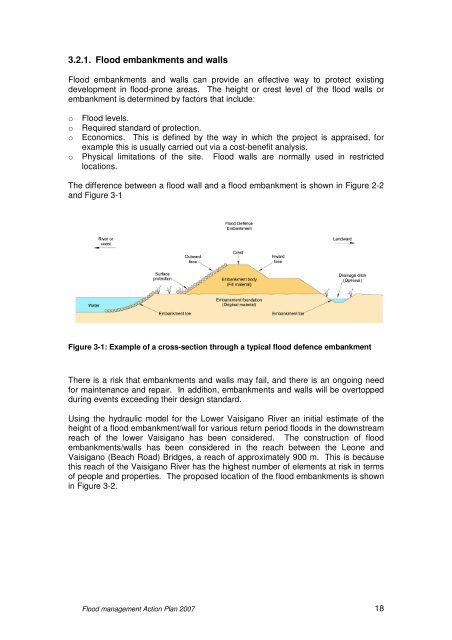
3.2.1. Flood embankments and wallsFlood embankments and walls can provide an effective way to protect existingdevelopment in flood-prone areas. The height or crest level of the flood walls orembankment is determined by factors that include:o Flood levels.o Required standard of protection.o Economics. This is defined by the way in which the project is appraised, forexample this is usually carried out via a cost-benefit analysis.o Physical limitations of the site. Flood walls are normally used in restrictedlocations.The difference between a flood wall and a flood embankment is shown in Figure 2-2and Figure 3-1Figure 3-1: Example of a cross-section through a typical flood defence embankmentThere is a risk that embankments and walls may fail, and there is an ongoing needfor maintenance and repair. In addition, embankments and walls will be overtoppedduring events exceeding their design standard.Using the hydraulic model for the Lower Vaisigano River an initial estimate of theheight of a flood embankment/wall for various return period floods in the downstreamreach of the lower Vaisigano has been considered. The construction of floodembankments/walls has been considered in the reach between the Leone andVaisigano (Beach Road) Bridges, a reach of approximately 900 m. This is becausethis reach of the Vaisigano River has the highest number of elements at risk in termsof people and properties. The proposed location of the flood embankments is shownin Figure 3-2.Flood management Action Plan <strong>2007</strong> 18