
Create successful ePaper yourself
Turn your PDF publications into a flip-book with our unique Google optimized e-Paper software.
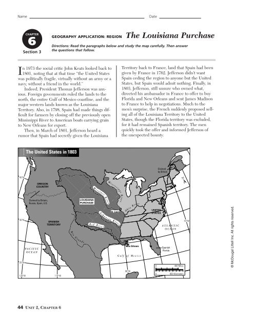
NameDateCHAPTER6Section 3GEOGRAPHY APPLICATION: REGIONThe Louisiana PurchaseDirections: Read the paragraphs below and study the map carefully. Then answerthe questions that follow.In 1973 the social critic John Keats looked back to1801, noting that at that time “the United Stateswas politically fragile, virtually without an army or anavy, without a friend in the world.”Indeed, President Thomas Jefferson was anxious.Foreign governments ruled the lands to thenorth, the entire Gulf of Mexico coastline, and themajor western lands known as the LouisianaTerritory. Also, in 1798, Spain had made things difficultfor farmers by closing off the previously openMississippi River to American boats carrying grainto New Orleans for export.Then, in March of 1801, Jefferson heard arumor that Spain had secretly given the LouisianaTerritory back to France, land that Spain had beengiven by France in 1762. Jefferson didn’t wantSpain ceding the region to anyone but the UnitedStates, but Spain would admit nothing. Finally, in1803, Jefferson, still unsure who owned what,directed his ambassador in France to offer to buyFlorida and New Orleans and sent James Madisonto France to help in negotiations. Much to themen’s surprise, the French suddenly proposed sellingall of the Louisiana Territory to the UnitedStates, though the Florida territory was excluded,for it had remained Spanish territory. The menquickly took the offer and informed Jefferson ofthe unexpected bounty.The United States in 1803Claimedby Britain45°NNOREGONCOUNTRYMiss o uriM i s s is sippiR35°N25°NClaimed by Britain,Russia, Spain, U.S.P A C I F I COCEANSPANISHTERRITORYRioG raLOUISIANAPURCHASEndeRe dA r k aR i v erR i v e rnSt. Louiss a s R i ve ri v e rO h i oR i vNew OrleansG u l f o f M e x i c oerUNITEDSTATES0A T L A N T I COCEANSpanishFlorida400 Miles70°W© McDougal Littell Inc. All rights reserved.120°W 110°W90°W080° W800 Kilometers44 Unit 2, Chapter 6
NameThe Louisiana Purchase continuedInterpreting Text and Visuals1. What were the approximate latitude and longitude boundaries of the UnitedStates before the Louisiana Purchase?After the Louisiana Purchase?2. What country controlled territory to the north of the U.S. boundary?To the south and west?3. What seaport did the United States gain through the Louisiana Purchase?4. By what proportion did the size of the United States increase as a result of the purchase?5. After the purchase, what formed our eastern and western boundaries?6. Control of which natural feature was the most important geographical advantageof the purchase?© McDougal Littell Inc. All rights reserved.7. U.S. possession of the Louisiana lands gave what four other major rivers permanentaccess to New Orleans and export-shipping facilities?8. In addition to the advantage of increasing the nation’s size, what risks do youthink acquiring all this land presented?Launching the New Nation 45