New Hazelton Inset Map Village of Hazelton Inset Map - Smithers
New Hazelton Inset Map Village of Hazelton Inset Map - Smithers
New Hazelton Inset Map Village of Hazelton Inset Map - Smithers

You also want an ePaper? Increase the reach of your titles
YUMPU automatically turns print PDFs into web optimized ePapers that Google loves.
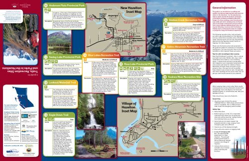
KA visit to the <strong>Hazelton</strong>s is to travelto the Historic Heartland <strong>of</strong>Northwest British Columbia.It is a place <strong>of</strong> unequaled naturalbeauty—a place rich in First Nationsand pioneer history pr<strong>of</strong>oundlyinfluenced by this geography.a guide toTrails, Recreation Sitesand Parks in the <strong>Hazelton</strong>sFor more informationregarding recreationalopportunities in the<strong>Hazelton</strong>s area contact:<strong>Hazelton</strong>s Visitor CentreBox 340, <strong>New</strong> <strong>Hazelton</strong>, BCV0J 2J0June to Sept. 250-842-6071Off-season 250-842-6571tourism@newhazelton.cawww.hazeltonstourism.caRecreation Sites & Trails BCMinistry <strong>of</strong> Forests, Landsand Natural ResourceOperations, Nadina/SkeenaRecreation District<strong>Smithers</strong>, BC • 250-847-6300www.sitesandtrailsbc.caBC Parks3726 Alfred Ave., <strong>Smithers</strong>,BC V0J 2N0250-847-7320www.env.gov.bc.ca/bcparksProduced in northern BC, 2012www.SparkDesignCo.comThe <strong>Hazelton</strong>sBritish ColumbiaA cooperative project <strong>of</strong>:<strong>Hazelton</strong>sVisitorCentrePhoto creditsBen Heemskerk • AndrewWebber • Recreation Sites &Trails BC • Regional District <strong>of</strong>Kitimat-Stikine • Barbara Schwab• Brenda Schwab • David SchwabBulkley Valley Printerswww.bvprinters.com10 Anderson Flats Provincial ParkAccessDescriptionAt approx. 3.7km west <strong>of</strong> the <strong>Hazelton</strong>s VisitorCentre (in <strong>New</strong> <strong>Hazelton</strong>) on Highway 16, turnright into South <strong>Hazelton</strong> on Omineca Avenue;after 700 metres descend the hill by turning righton to <strong>Hazelton</strong> Station Road.Exceptional views <strong>of</strong> the Rocher de BouleMountain Range and easy access to the Skeenaand Bulkley Rivers are to be enjoyed at AndersonFlats. This day use recreation site at the Rivers’confluence is favoured for recreational fishing.Seeley Lake11 Seeley Lake Provincial ParkAccessDescription9.8km west <strong>of</strong> the <strong>Hazelton</strong>s Visitor Centre(in <strong>New</strong> <strong>Hazelton</strong>) on Highway 16.The <strong>Hazelton</strong> Mountains form a beautifulbackdrop to this picturesque lake. The park<strong>of</strong>fers a small, sandy beach for swimming,short lakeside trails and a viewing platform.12 Lookout/Waterfall TrailAccessDescription13 Eagle Down TrailAccessDescriptionThe trailhead for the <strong>New</strong> <strong>Hazelton</strong>Lookout Trail is located <strong>of</strong>f <strong>of</strong> aparking lot at the south end <strong>of</strong>Laurier Street in <strong>New</strong> <strong>Hazelton</strong>.Ideal for a short afternoon familyhike. A 15 minute walk throughforest leads to a beautiful waterfall.At the top <strong>of</strong> the path after a 30minute walk is the lookout, affordinga great view over <strong>New</strong> <strong>Hazelton</strong>, TwoMile and surrounding mountains.EasyCan start walk from <strong>Hazelton</strong>sVisitor Centre walking theshoulder <strong>of</strong> Highway 62 or parkat Hagwilget Canyon or in the<strong>Village</strong> <strong>of</strong> <strong>Hazelton</strong>.Ideal for a leisurely way toexperience the beauty andhistory <strong>of</strong> the <strong>Hazelton</strong>s,the Eagle Down Trail linksfive communities: <strong>Hazelton</strong>,Gitanmaax, Two Mile,Hagwilget and <strong>New</strong> <strong>Hazelton</strong>.Interpretive panels tell <strong>of</strong> therich First Nations, pioneer andnatural history <strong>of</strong> the area.A highlight is the HagwilgetCanyon Bridge, 80 metresabove the Bulkley River. Trail issuitable for walking, joggingand cycling. Total distance fromthe Visitor Centre to the <strong>Village</strong><strong>of</strong> <strong>Hazelton</strong> is 7km.13 62Eagle DownTrailCollege StJoseph RdBrewster StHagwilgetCanyonBridgePBulkley RiverP4th Ave.Hagwilget6th<strong>Hazelton</strong>sVisitorCentreCanadian National RailwayAlderway LoopPark LaneChurchill11th13th15thPugsley7th Ave.9th Ave.10th Ave.12th14 Blue Lakes Recreation TrailAccessDescriptionModerate to Difficult9.2km east <strong>of</strong> the <strong>Hazelton</strong>s VisitorCentre (in <strong>New</strong> <strong>Hazelton</strong>) on Highway16, turn right on to a gravel road (nearMudflat Creek). Take the first fork rightat 200 metres, follow signs from thispoint. 4wd required to travel entire4.2km from highway. (Check RecreationSites and Trails BC or the <strong>Hazelton</strong>sVisitor Centre for current informationon trail access.)Described as the “signature trail” <strong>of</strong>the <strong>Hazelton</strong>s area, the Trail follows apath to historic mining claims, throughopen hemlock forest, to reward withstunning views <strong>of</strong> alpine lakes andpeaks. There are some steep sectionsbut generally a gradual climb gaining400 metres from the parking area at4.2km along the road. The round tripfrom the parking area is 10km.Lookout/Waterfall TrailEagle Down TrailWetland TrailBowser St.<strong>New</strong> <strong>Hazelton</strong><strong>Inset</strong> <strong>Map</strong>McLeod St.Breakover Trail(under const. 2012)ellyTemplemanLaurier StMcBride6thMcBride StGrahamAllenPark16Oliver St12th Ave.Lookout/WaterfallTrail12<strong>Village</strong> <strong>of</strong><strong>Hazelton</strong><strong>Inset</strong> <strong>Map</strong><strong>Hazelton</strong>Ferry RdRiver EdgeTrailBiernes StRiver RoadBulkley JunctionProvincial ParkBastionPark7th Ave.9th Ave.<strong>New</strong> <strong>Hazelton</strong>OminecaCliffordWrinch‘KsanStation CreekTrail16Skeena RiverGovernment StField StBench RdSkeena Rd HilltopJohn FieldRdSkeena/AnlawTrailPack TrainTrailRdTotem RdBulkley RiverTo Kispiox ValleyPine Cres.Anderson FlatsProvincial ParkSpruce StKispiox Valley RdCottonwoodJuniper LaneCairn at Blunt Mtn (Skilokis) v15 Ross Lake Provincial ParkAccessDescription3.3km east <strong>of</strong> the <strong>Hazelton</strong>s VisitorCentre (in <strong>New</strong> <strong>Hazelton</strong>) on Highway 16,turn left at Ross Lake Road. The park is4km along Ross Lake Rd.Popular with locals for swimmingand afternoon BBQ’s, the park <strong>of</strong>fersa pleasant beach and a boat launch(electric motors only). The 3.5kmRainmaker Trail circles the lake, providingexcellent views <strong>of</strong> the surroundingmountains, lakeshore vegetation andwildlife. Perimeter Trail is a 2km branchfrom Rainmaker Trail, through mixedforest; optional trail connection back to<strong>New</strong> <strong>Hazelton</strong>.910Skeena ViewEasyGitanmaaxMountainviewCres.Cottonwood Dr.PoplarStForest RdHospitalSdikyoodinaxCres.1 kmSwannell Dr.Janze Way16 Station Creek Recreation TrailAccessHospitalLakeHighSchoolDescriptionWiggins WayIceArenaBulkley CanyonViewpont TrailA gravel road extends from the south end <strong>of</strong>McBride Street in <strong>New</strong> <strong>Hazelton</strong>. This road isgated at 800 metres.For the first 3.5km from the end <strong>of</strong> McBrideStreet the path gains about 200 metres inelevation, then rises steeply beyond this point.For experienced, equipped hikers only, this is alsothe route leading to Hagwilget Peak. In its lowerreaches it is a well constructed trail through anattractive section <strong>of</strong> thick forest.62Eagle DownTrail<strong>Village</strong> <strong>of</strong> <strong>Hazelton</strong>Two MileLoop TrailEasy to Difficult17 Sidina Mountain Recreation TrailAccessDescriptionModerate to Difficult3km from the start <strong>of</strong> the Kispiox Valley Road inGitanmaax, turn right on to the Salmon River Road.After the Shegunia River at 9km the road becomesthe Babine Slide FSR. Follow this road for 6km (1kmbeyond Pine Nut Creek), turn right on to the oldlogging road, for 4km.Gaining 1000 metres in elevation over 6.3kms, thetrail ascends to alpine slopes on the southwestshoulder <strong>of</strong> Sidina Mountain and panoramicviews <strong>of</strong> the Rocher De Boule and Kispiox Rangesand the Kispiox and Skeena Valleys. (Note: Trailcondition cannot be guaranteed due to irregularmaintenance.)18 Suskwa River Recreation SiteAccessDescriptionOn Highway 16, 11.7km east <strong>of</strong> the <strong>Hazelton</strong>sVisitor Centre, turn left on to the SuskwaForest Service Road. At 15km, cross thebridge over Suskwa River and immediatelyturn left. Site entrance sign is a further 2kmon the Iltzul Forest Service Road.Scenic site on the north side <strong>of</strong> the SuskwaRiver. 3 unit campsite, plus space for overflowparking and camping. Rock climbing wall isnearby.13SilverStandard RoadTwo MileGeneral informationThis guide is an introduction to walking andoutdoor recreational opportunities that await thevisitor to the <strong>Hazelton</strong>s. For the adventurous,trails to alpine ascend the dramatic landscapes<strong>of</strong> the Rocher de Boule and Babine MountainRanges. For those seeking a more leisurely pace,easy walks and scenic camping areas are foundclose to the larger communities and just minutesfrom a main highway. Walking these trails, onemay be following a centuries old First Nationstrading route or retracing the steps <strong>of</strong> a trapperor prospector. Enjoy the <strong>Hazelton</strong>s experience!The following recreation sites, trails and parksare within easy driving distance <strong>of</strong> the <strong>Hazelton</strong>sand are 2 wheel drive accessible unless otherwisenoted. Distances given are one way and generallystarting from the <strong>Hazelton</strong>s Visitor Centre onHighway 16 in <strong>New</strong> <strong>Hazelton</strong>.Please note that backcountry trails presented inthis guide are subject to occasional or inconsistentmaintenance. You may encounter trees on the trail(windfall) or other hazards. Please use caution.Tips for safe recreating in bear countryBears feel threatened if surprised – hike in a groupand make loud noises. Whistle, talk, sing or carrynoisemakers such as bells or a can containingstones. In dense brush and near running water,don’t depend on your noisemaker being heard. Useextra caution and watch for evidence <strong>of</strong> bears.Most bears will leave if they are aware <strong>of</strong> yourpresence. Stay in the open as much as possible.Keep children close at hand on trails. Be especiallyalert when travelling into the wind; a bear may notget your scent and be warned <strong>of</strong> your presence.When camping, keep a clean camp. Bears usuallyavoid people, but can be attracted to human foodand garbage. Store and dispose <strong>of</strong> all food andgarbage properly. In unmaintained sites, take yourgarbage with you.Take only pictures, leave only footprints.Forest Fires• Should you spot a forest fire, phone1-800-663-5555 (or *5555 where cellular phoneservice is available). This is a FREE provincewide, forest fire emergency phone number.Safety Tips• Never hike alone• Before leaving on a hike, let a responsibleindividual know where you are going andwhen you will be returning. Always contactthat individual when you return.• Some trails are not clearly marked. Beprepared and take a map, compass, food,emergency gear and a GPS Unit.• Assume you will be staying overnight.• Drive with extra caution on logging roads.• In case <strong>of</strong> emergency dial911. The nearest RCMPdetachment is in <strong>New</strong><strong>Hazelton</strong>. The principalhealth services facility isWrinch Memorial Hospitallocated in the <strong>Village</strong> <strong>of</strong><strong>Hazelton</strong>.• Cellular phone service isavailable only in limitedareas covered by thisbrochure.Kispiox Totem Poles
FollowYourPath <strong>Map</strong>ping<strong>Hazelton</strong>sOverview <strong>Map</strong>CedarvaleDorreen1KitwangaLakeKitwangaMountainParkSeven SistersProvincial ParkGitanyow37KitwangaTrails, Recreation Sites and Parksin the <strong>Hazelton</strong>s1.2.3.4.5.6.7.8.9.Watson Lakes Trail2Sedan Creek Recreation SiteNature’s Way (Kitwanga)43Kispiox RiverDate CreekResearch ForestKispiox Mtn.S k e e n aGitwangak Battle Hill/Kitwanga Fort National Historic SiteElizabeth Lake Recreation SiteUpper Kispiox Recreation SitePentz Lake Recreation SiteKeynton (Bell) Lake Recreation SiteSkeena/Anlaw Trail567Re ri vKispioxGlen Vowell<strong>Hazelton</strong>'KsanBulkley JunctionProvincial Park8Kitseguecla11910Sidina MtnShegunia River1213<strong>New</strong><strong>Hazelton</strong>Hagwilget Peak14Brian Boru PeakMt. ThomlinsonNine Mile Mtn.Suskwa Riv erMoricetownBulkley River0 10 20 30 40 50 60 Kilometers171516Difficulty levelEasyModerate1618Blunt Mnt.(Skilokis)DifficultRecreational featuresBoat LaunchBoatingCampingHikingJoggingPicnicking1 Watson Lakes TrailAccessDescriptionModerateApprox. 80km west <strong>of</strong> the <strong>Hazelton</strong>s VisitorCentre, (36.9km west <strong>of</strong> Kitwanga junctionand about 2km after Hells Bells Creek), anunmarked 700 metre access road leavesHighway 16 on the left side <strong>of</strong> the highway.Covering nearly 40,000 hectares, SevenSisters Park and Protected Area is namedfor the spectacular set <strong>of</strong> peaks visible fromHighway 16 between <strong>Hazelton</strong> and Terrace.The area <strong>of</strong>fers a variety <strong>of</strong> trails, cateringto all levels <strong>of</strong> ability. Many <strong>of</strong> the trails area legacy <strong>of</strong> mining and mineral exploration.The Watson Lakes Trail is the most suited forfamilies. There is one short steep pitch butotherwise it is an easy 3km trail passing threescenic lakes and on the ascent views acrossthe Skeena River to Mt. Knauss. At 1km,there is a lakeside picnic and camping site.2 Sedan Creek Recreation SiteAccess Starting at the junction with Highway 16near Kitwanga, drive north on Highway 37,crossing the bridge over the Skeena Riverand shortly afterward the rail line. Turnleft on to the Cedarvale-Kitwanga Road(Cedarvale Backroad). At approx. 8km, thereis a sign and parking area for three vehicles.DescriptionOne <strong>of</strong> the best views <strong>of</strong> the Seven SistersMountains is from this day-use site. A short(easy) trail takes you to 2 picnic tables at thecrest <strong>of</strong> a ridge.3 Nature’s Way (Kitwanga)AccessDescriptionEasyFrom the junction with Highway 16, at 4.3kmnorth along Highway 37, turn left on to theKitwanga North Road. Sections <strong>of</strong> the trailare visible on the left side.A 3.2km loop through Kitwanga, linkingthe Recreation Centre with the sports fields,featuring viewing platforms over Mill Pond.4 Gitwangak Battle Hill/Kitwanga FortNational Historic SiteAccessDescriptionNature’s Way (Kitwanga)EasyAt 4.3km north along Highway 37, turnleft onto Kitwanga North Road into thecommunity <strong>of</strong> Kitwanga. A pull-out is locatedon the left side at 1.7km. Visitors mustdescend and ascend a long staircase to reachthe fort.At a strategic location overlooking theKitwanga River and along a “Grease Trail”trading route, in the 1700s Gitxsan peopleconstructed a hilltop fort. Parks Canadarelates the fascinating story <strong>of</strong> ‘Nekt’sfortress through a series <strong>of</strong> interpretivepanels along a short walk to the hill top.5 Elizabeth Lake Recreation SiteAccessDescriptionElizabeth LakeApprox. 54.5km on the Kispiox Valley Road; rightturn approx. 8km after Cullen Creek.Small, semi-open site on a lake popular withpaddlers. 3 campsites and overflow space.Wheelchair accessible outhouse and a dock.Access may be prohibitive for large RVs and trailers.6 Upper Kispiox Recreation SiteAccessDescriptionApprox. 41km on the Kispiox Valley Road,on left side.Located on an open grassy field on theKispiox River, with 4 defined campsitesand 2 outhouses. Abundant space foroverflow camping and parking. A rusticlaunch provides river access for“car top boats”.Seven SistersPark &ProtectedArea16CedarvaleFlint CreekFlint CreekRoadHells Bells CkWatsonLakesTrailCoyote CreekCoyote CreekRoadHell BellsTrailOliver Creek TrailOliver CreekProtected AreaWhiskey CreekTrailWhiskey CreekPark^^ ^ ^^Boulder CreekBoulder Creek TrailWeekinisht Peak^^ ^ ^Mount^ Quinlan7 Pentz Lake Recreation SiteAccessAt approx. 26km on the Kispiox ValleyRoad (after the Rodeo Grounds) turn left,cross the Kispiox River and turn right onto Poplar Park Road. Site is 11.8km north,approx 5km after junction with Helen LakeRoad and 500 metres after McCully Creek.Description Two day use sites are connected by a 400metre trail. South site has a boat launchand picnic tables; north site has a dock &raft and picnic tables.8 Keynton (Bell) LakeRecreation SiteAccessDescription16.8 km north <strong>of</strong> the junctionwith Highway 16 nearKitwanga, from Highway 37turn right on to the KitwangaBackroad (<strong>Hazelton</strong>-KitwangaRoad). At approx. 16.5km, turnleft on to the Burdick Road,keep right, for approx. 1.5km.(No access from <strong>Hazelton</strong>/Kispiox Valley.)A beautiful semi-open forestedsite on a small lake, <strong>of</strong>fering 8campsites. Good bird watching.Popular with anglers seekingpan-sized cutthroat trout inspring and fall.2Price CreekParkProtected AreaKitwanga37Gitwangak3 0 3 6km9 Skeena/Anlaw TrailAccessDescriptionEasy to ModerateBeginning at 1.3 km north <strong>of</strong>the junction with Highway 62 onthe Kispiox Valley Road, the trailparallels the Road on the leftside for 200 metres then turnstowards the Skeena River.A pleasant 3.5kmEasywalkto Moderateupstream, north from <strong>Hazelton</strong>to the Anlaw or Four MileBridge. Gorgeous views <strong>of</strong>the Skeena River and Rocherde Boule Range. Culturallymodified trees are also seenalong this route. One may returnvia the same trail or alongsidethe Kispiox Valley Road.10. Anderson Flats Provincial Park11. Seeley Lake Provincial ParkCanoeingRock Climbing12. Lookout/Waterfall Trail13. Eagle Down TrailCyclingSwimmingHagwilget Peak14. Blue Lakes Recreation Trail15. Ross Lake Provincial Park16. Station Creek Recreation Trail17. Sidina Mountain Recreation Trail18. Suskwa River Recreation SiteFishingWalkingWildlifeViewingKitwanga FortBlue Lakes