CONTENTS
Delta-State-Bond-Shelf-Prospectus
Delta-State-Bond-Shelf-Prospectus
- No tags were found...

Create successful ePaper yourself
Turn your PDF publications into a flip-book with our unique Google optimized e-Paper software.
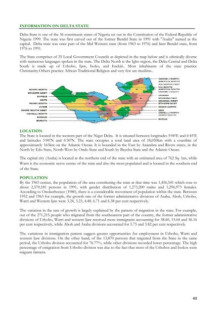
INFORMATION ON DELTA STATEDelta State is one of the 36 constituent states of Nigeria set out in the Constitution of the Federal Republic ofNigeria 1999. The state was first carved out of the former Bendel State in 1991 with "Asaba" named as thecapital. Delta state was once part of the Mid Western state (from 1963 to 1976) and later Bendel state, from1976 to 1991.The State comprises of 25 Local Government Councils as depicted in the map below and is ethnically diversewith numerous languages spoken in the state. The Delta North is the Igbo region, the Delta Central and DeltaSouth is made up of Urhobo, Ijaw, Isoko, and Itsekiri.. Most inhabitants of the state practiceChristianity.Others practice African Traditional Religion and very few are muslims..LOCATIONThe State is located in the western part of the Niger Delta. It is situated between longitudes 5 ◦ 00’E and 6 ◦ 45’Eand latitudes 5 ◦ 00’N and 6 ◦ 30’N. The state occupies a total land area of 18,050km with a coastline ofapproximately 163km on the Atlantic Ocean. It is bounded in the East by Anambra and Rivers states, in theNorth by Edo State, North-West by Ondo State and South by Bayelsa State and the Atlantic Ocean.The capital city (Asaba) is located at the northern end of the state with an estimated area of 762 Sq km, whileWarri is the economic nerve centre of the state and also the most populated and is located in the southern endof the State.POPULATIONBy the 1963 census, the population of the area constituting the state at that time was 1,456,541 which rose toabout 2,570,181 persons in 1991, with gender distribution of 1,273,200 males and 1,296,973 females.According to Onokerhoraye (1980), there is a considerable movement of population within the state. Between1952 and 1963 for example, the growth rate of the former administrative divisions of Asaba, Aboh, Urhobo,Warri and Western ljaw were 3.24, 3.23, 4.48. 6.71 and 6.38 per cent respectively.The variation in the rate of growth is largely explained by the pattern of migration in the state. For example,out of the 271,215 people who migrated from the southeastern part of the country, the former administrativedivisions of Urhobo, Warri and western ljaw received more immigrants accounting for 38.60, 15.64 and 36.16per cent respectively, while Aboh and Asaba divisions accounted for 5.75 and 3.82 per cent respectively.The variations in immigration pattern suggest greater opportunities for employment in Urhobo, Warri andwestern ljaw divisions. On the other hand, of the 13,870 persons that migrated from the State in the sameperiod, the Urhobo division accounted for 76.77%, while other divisions recorded lower percentage. The highpercentage of emigration from Urhobo division was due to the fact that most of the Urhobos and Isokos weremigrant farmers.40