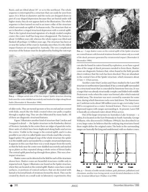
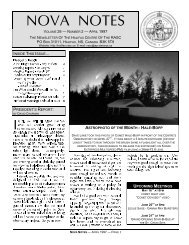
Basin, and are tilted about 10˚ or so to the northeast. The wholesequence is interrupted by a structure that can easily be seen fromspace. It is 30 km in diameter and the rocks are dropped down inpart of a ray-shaped depression; because they are buried under stillhigher strata, they do not appear dark in the illustration. The wholesequence is then turned on end in an inner collar of the structurewhich surrounds an uplift of Archaean rocks. The structure that wesee is therefore a ringed structural depression with a central uplift.That is the typical structural signature of a deeply eroded complexcrater; the crater itself has long since disappeared. The feature isabout 1.6 billion years old, whereas the whole region was tilted andflanked off perhaps 1.2 billion years ago. The structure has been ator near the surface of the crust in Australia since then. It is the oldestimpact feature yet recognized in Australia. The very complicatedstructure of the feature must be deciphered by finding the outcropsFig.3 — Oblique aerial view of the low-impact Spider structure showingbeds near the centre skidded successively and stacked in ridges along thrustfaults (Shoemaker & Shoemaker 1996).of older rocks. They are turned up more or less on end and are coveredwith folds, much like the folds created when one pulls a napkinthrough a napkin ring. They are also bifurcated by many faults. Allof these are diagnostic structural features.Figure 3 illustrates another kind of structure that Carolyn andI mapped in detail — the Spider structure in the Kimberley districtof Western Australia. In the centre there are ridges of quartzite rocks,three units of which have been duplicated along faults and acrossthe centre. Visible in the image is the central uplift, and it is alsopossible to see why it is called Spider since it looks much like a twentyleggedspider. On a geological map of the whole structure the spideris in the middle and is surrounded by a complex structural depression.It appears in this case that there was a weak impact from the north,so that the beds near the centre were skidded successively and stackedup as plates as they repeated along a whole series of thrust faults.The central uplift punched up through those plates. This was a lowimpactstructure.Shatter cones can be detected in the field for each of the structuresshown here. Shatter cones are beautiful structures visible only inimpacted rock. Figure 4 illustrates one found on the Spider structure,where they are located on the central uplift. Shatter cones have conicalsurfaces, or portions of conical surfaces, that are decorated withfantail or horsetail kinds of striations formed by shock. They can becreated by shock on a small scale in laboratory experiments; theyFig. 4 — Large shatter cones on the central uplift of the Spider structureare conical features with horsetail striations formed in nature only as a resultof the shock pressures generated by extraterrestial impact (Shoemaker &Shoemaker 1996).can also be found in craters formed by explosives, so we have a goodidea of the range of shock pressures needed to form them. Shattercones are diagnostic features that, when found in the field, providedirect evidence that the rock has been shocked. They are abundantin the central 2 km of the Spider structure, which measures about11 km 13 km across.Another crater that Carolyn and I have studied is the Lawn Hillstructure in northwestern Queensland. It has a central uplift surroundedby a structural moat that is concealed by limestone breccias. It wasa target that was already structurally complex and folded with middleProterozoic rocks when the crater was formed, after which materialeroded away. The structure was next covered by seawater for sometime, during which limestone rocks were laid down. The limestonesare Cambrian rocks about 500 million years in age; even today LawnHill is recognized as a crater-formed feature. There is a centraldepressed region with ranges surrounding it. At present, Lawn Hillis basically an exhumed crater about 20 km across.One of the larger structures in Australia is Lake Acraman — asalina. It is located on the Eyre Peninsula in South Australia. GeorgeWilliams, who discovered it (Williams 1994a,b), has described it asa very large crater; he believes that the outlying ring structures foundthere might define the original crater. The beds in the surroundingranges are basically flat lying and undeformed, with no shatter cones;Fig. 5 — Density of noble metals (iridium, gold, platinum, palladium) andchromium, another iron-loving metal, reveal elevated abundances in theLake Acraman fallout layer (Wallace et al.1990).300JRASC December/décembre 1998
they appear to be fairly normal-looking rocks that have not beensubject to shock. The actual crater is a topographic basin about 40km in diameter. The reason why the lake is present is that the rocksin the centre, which were crushed and broken by shock, eroded toform the low spot presently visible in the topography. The age of thecrater is estimated quite accurately on the basis of stratigraphy. VictorGostin of the University of Adelaide discovered a fallout deposit fromthe crater in the steeply inclined rock beds in the Flinders Rangeabout 250 km from Acraman. Within the Range there is a bed ofmaterial a couple of centimetres thick that was ejected from theAcraman crater. It is part of a 10-km-thick sequence of late Proterozoicsediments, a very specific tracer in that huge stack of sedimentarydeposits. The rock is of Precambrian age, about six hundred millionyears old; it is the first distant fallout deposit discovered from arelatively large crater.Close examination of a fallout deposit reveals shocked rocksthat have small shatter cones within them. Also detected are featurescontaining tiny spherules of material that was once molten, quartzgrains that have structural features formed by shock, and contaminatingfragments of the impacting body. The abundance of the so-callednoble metals — iridium, gold, platinum, and palladium — and otheriron-loving elements like chromium is about ten thousand timeshigher in the average meteorite than in the average rock in the Earth’scrust. Elevated abundances of such elements are therefore a nicetracer of the impacting body. Samples obtained for the beds in theAcraman structure, for example, provide evidence for the presenceof a distinct fallout layer (figure 5), where there is an increase in theabundance of iridium to a peak of close to one and a half parts perbillion. That is a lot of iridium, given that the average amount foundin sediments in crustal rocks is about ten parts per trillion. The goldabundance is also anomalous, as is platinum, which is about two toTable IISizes and Ages of Australian Proterozoic Impact StructuresCrater Diameter Probable Age MethodAcraman ~35 km 600 Ma StratigraphicLawn Hill 20 km 500–1000 Ma StratigraphicStrangways ~40 km ~1000 Ma (?)39Ar/ 40 Ar DatingKelly West ~8 km 500–1600 Ma StratigraphicSpider 12 km 700–1600 Ma StratigraphicTeague Ring 30 km ~1600 Ma Rb/Sr DatingLiverpool 1.7 km < 1500 Ma StratigraphicGlikson ~18 km < 1000 Ma (?) Stratigraphicthree times as abundant as iridium in impacting objects. In fact,platinum is the most abundant of the elements brought to Earththrough impacts.Table II lists all Australian structures of Precambrian or Proterozoicage, where the Proterozoic represents the last part of the Precambrianera. One of the structures may belong to the Cambrian era, and thereare a couple of newly studied structures that are probably in the sametime range, although their ages are not known accurately and theyare smaller than the others. Small structures are lost by erosion andare therefore more difficult to find, so their numbers are usuallyunrepresentative of the entire sample. There are four structures thatare 20 km or larger indiameter: Acraman,Lawn Hill, Strangways,and Teague Ring. In acumulative frequencydistribution they producethe results presented infigure 6, which plots thelogarithm of thecumulative number asa function of thelogarithm of thediameters. Rememberthat the grand statisticfor craters greater thanor equal to 20 km indiameter is just fourstructures in Australia.The best fit for the lunardata is given by thedotted line. Thediameters of the fourFig. 6 — Cumulative size-frequency distributionof Proterozoic impact structures in Australia(Shoemaker & Shoemaker 1996).features are reasonably well established, but of course the uncertaintiesin the cumulative number densities are very large for such a smallsample. The cratering rate for Australia is established from an areaof a little over a million square kilometres covered by the gentlydeformed Proterozoic rocks, where one can actually search for craterson an exposed surface, and from an exposure age equivalent to theduration of the Proterozoic era — slightly less than a billion years.The combination implies an average cratering rate for Australia of(3.8 ±1.9) 10 –15 km –2 yr –1 , as given in Table I, compared with anestimated cratering rate for lunar craters of (3.7 ±0.4) 10 –15 km –2yr –1 for the Eratosthenian era. Normally one would not expect toobtain such good agreement to within the statistical uncertainties,but the result is nevertheless intriguing.4. Young CratersLet us now examine young craters on the Earth. Australia is the onlyplace where one can examine the cratering rate for early Earth history,but one can also examine a larger area of the Earth by consideringthe global distribution of craters. Figure 7 is a map from Grieve &Shoemaker (1994) that is revised annually as more craters are discovered.Figure 7 represents the status, as of 1994, of craters that Grieve iswilling to consider as true impact structures. There are severalinteresting features of the distribution. There are no craters in theocean, of course, and for the continents the distribution is very nonuniform.There is also a large cluster of craters in North America,another one in Europe, and a fairly large one in Australia. Why isthat? Since impacting objects strike the Earth fairly randomly, thehistory of such impacts should be recorded as a relatively uniformdistribution of craters. However, three factors contribute to theobserved non-uniformity: one is geological and two are sociological.The geological factor concerns portions of the continents, calledcratons, which are relatively stable against the forces of erosion. Forexample, the Canadian Shield is a portion of a larger stable regioncalled the North American craton, parts of which are very thinlyDecember/décembre 1998 JRASC301