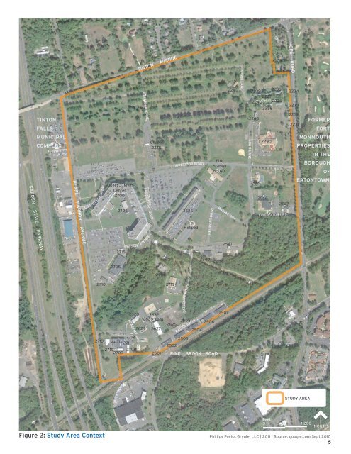
TINTON FALLS TINTON AVENUE BATAAN AVENUE 2241 GUAM LANE 2239 2235 2237 2240 2236 HEMPHILL RD 2238 2260 HOPE ROAD 2234 2233 2232 2231 FORMER FORT MUNICIPAL COMPLEX Chapel 2275 CORREGIDOR ROAD Fire Station 2560 GUAM LANE 2290 MONMOUTH PROPERTIES IN THE BOROUGH OF CORPUT PLAZA DR Albert J. Myer Center 2700 2706 LABORATORY ROAD 2525 Helipad HELIPORT DRIVE RADIAC WAY 2569 2566 2567 LABORATORY RD EATONTOWN PEARL HARBOR AVENUE GARDEN STATE PARKWAY 2715 WATSON AVENUE 2541 2705 2540 2539 2704 2718 2628 ACADEMY AVE 2712 2713 2707 2711 2710 2709 2708 2632 2630 2631 2629 2627 2501 2719 SATELLITE ROAD 2508 2506 2625 2504 2503 2502 PINE BROOK ROAD RADAR AVENUE 2507 STUDY AREA Feet 0 1,200 Figure 2: Study Area Context Phillips Preiss Grygiel LLC | 2011 | Source: google.com Sept 2010 5 NORTH
There were also facilities for the families of service members including residences, community centers, and daycare facilities. As a result, various specialized facilities are located throughout the fort generally and in Tinton Falls particularly. Additional activities that occurred on the <strong>Fort</strong> included the performance of research, development, procurement, and production of electronic material for use by the United States Armed Forces. Other missions included the provision of administrative training and logistical and related support necessary to transition selected reserve component units into the active force structure in the event of a natural emergency. The extant structures in the study area site include 49 buildings from among the following types: administration/research, development, test and evaluation (Admin/RDT&E); commercial; housing; public works/supply/utilities/storage; and recreation/community facilities (see Figure 3). Some of the buildings are small and were used primarily for storage, maintenance and utilities, while others are much larger and were used for highly specialized office and laboratory operations. There is over one million square feet of floor area in total. All of the buildings are presently vacant. In addition, the study area includes open space and recreation facilities, including a softball field, surface parking, and a helipad. A summary of the use, square footage and age of the various buildings is provided in Table 1. Within the portion of the fort located generally north of Corregidor Road and west of Guam Lane, numerous buildings were demolished between 2001 and 2003. These buildings were principally used as family housing for service members. Demolition was done to encourage development funded by the U.S. Army’s Enhanced Use Lease (EUL) Program. EUL is a method for funding construction or renovations on military lands by allowing a private developer to lease underutilized property. The only buildings in this roughly 80‐acre area that are intact at this time are Buildings 2275 (a former chapel) and 2241 (a former housing location). TABLE 1: SUMMARY OF EXTANT FORMER FORT MONMOUTH BUILDINGS IN TINTON FALLS Building Number Use Type Building/Property Description Gross Area (square feet) Year Built 2231 Housing Hemphill Housing 3,700 1955 2232 Housing Hemphill Housing 3,700 1955 2233 Housing Hemphill Housing 3,700 1955 2234 Housing Hemphill Housing 3,700 1955 2235 Housing Hemphill Housing 3,700 1955 2236 Housing Hemphill Housing 3,700 1955 2237 Housing Hemphill Housing 3,700 1955 2238 Housing Hemphill Housing 3,700 1955 2239 Housing Hemphill Housing 3,700 1955 2240 Housing Hemphill Housing 3,700 1955 2241 Housing Capehart Housing 4,692 1960 2260 Housing Hemphill Housing 3,700 1955 2275 Rec./ Comm.Fac. Chapel 3,279 1942 6