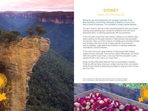
SYDNEY
SYDNEY
SYDNEY
- No tags were found...

Create successful ePaper yourself
Turn your PDF publications into a flip-book with our unique Google optimized e-Paper software.
<strong>SYDNEY</strong><br />
NEW SOUTH WALES<br />
Skirted by sea and bordered by the eucalypt-clad walls of the<br />
Blue Mountains, the thriving metropolis of Sydney is much more<br />
than a centre of business – it’s a windfall of unique natural habitats.<br />
You don’t need to roam far to find yourself dwarfed by blue gum forests,<br />
trekking along sparkling bays, diving into sheltered coves and iconic<br />
beachside baths, or admiring spectacular cliff-top panoramas.<br />
Follow the paths around the inner harbour, taking in iconic Sydney sites<br />
before seeking out the green patches of national parks that punctuate<br />
the suburbs. Here, you’ll find corridors of scribbly gums standing sentinel<br />
over winding rivers, and a troop of native animals: from possums,<br />
swamp wallabies, sugar gliders and echidnas to warbling wattlebirds<br />
and brilliantly coloured lorikeets.<br />
To the north and south, great swathes of national park offer walkers<br />
respite from the city bustle. The country’s oldest national park, the Royal,<br />
offers the sublime Coast Track, a two-day hike that we tackle in parts,<br />
capped off with a ferry ride or an ocean swim.<br />
Finally, the Blue Mountains National Park is a bushwalkers’ paradise.<br />
There are cliff-top hikes, strenuous, vertigo-inducing climbs, and serene<br />
strolls through stands of statuesque eucalypts to keep you ever coming<br />
back for more.<br />
Photo: Hanging Rock at Blackheath, Blue Mountains © Tourism Australia, Sue Wright<br />
Photo: Fresh apples in crates, Blue Mountains © Hamilton Lund; Destination NSW
Sandringham<br />
Harbour 33<br />
Hampton<br />
Sandringham Pier<br />
Yacht Club<br />
& Hampton<br />
Sailing Club<br />
Picnic Point<br />
JETTY RD<br />
Kiosk<br />
Sandringham Surf Life<br />
Saving Club<br />
P<br />
Red Bluff<br />
Red Bluff<br />
Lookout<br />
Half<br />
Moon<br />
HMVS 'Cerberus' Bay<br />
P Jetty<br />
Black Rock Point<br />
Half Moon Bay Surf Life Saving Club<br />
& Black Rock Yacht Club<br />
PORT<br />
PHILLIP<br />
0<br />
BEACH<br />
P<br />
Sandringham<br />
Beach<br />
Hampton<br />
Station<br />
Bay<br />
P<br />
Edward Street<br />
Beach<br />
HAMPTON<br />
Sandringham<br />
Station<br />
Trail<br />
Black Rock Surf Life<br />
Saving Club<br />
N<br />
500m<br />
RD<br />
HAMPTON ST<br />
THOMAS<br />
LINACRE<br />
BRIDGE<br />
P<br />
Black Rock Beach<br />
SANDRINGHAM<br />
ABBOTT<br />
BEACH<br />
BAY<br />
FERNHILL<br />
RD<br />
33<br />
SARGOOD<br />
P<br />
P<br />
RICKETTS<br />
ST<br />
ROYAL<br />
P<br />
Bay<br />
P<br />
Quiet<br />
Corner<br />
POINT<br />
Royal<br />
Avenue<br />
Res<br />
RED BLUFF ST<br />
RD<br />
LOVE<br />
ST<br />
P<br />
EBDEN AV<br />
19<br />
Royal<br />
Melbourne<br />
Golf Club<br />
Black Rock<br />
Fish & Chippery<br />
Trail<br />
Glamis<br />
Aveue<br />
Res<br />
Thomas<br />
Street<br />
Res<br />
ST<br />
BLUFF<br />
RD<br />
AV<br />
ST<br />
BLUFF<br />
RD<br />
Clock<br />
Tower<br />
Beaumaris<br />
North Beach<br />
Beaumaris<br />
Yacht Club<br />
ST<br />
19<br />
SPRING<br />
FOURTH<br />
RD<br />
LAWSON<br />
BAY<br />
Tjilatjirrin<br />
Reserve<br />
TULIP<br />
Royal Melb<br />
Golf Club<br />
CHELTENHAM<br />
BALCOMBE<br />
BEACH<br />
19<br />
MARINE P<br />
P<br />
Rickett's Point<br />
Beach Cafe<br />
SANCTUARY P<br />
Ricketts Point<br />
Beaumaris<br />
Surf Life<br />
Saving Club<br />
HAMPTON<br />
EAST<br />
WICKHAM<br />
Basterfield<br />
Park<br />
HIGHETT<br />
Bay Road<br />
Heathland<br />
Sanctuary<br />
Merindah<br />
Park<br />
ST<br />
RD<br />
HIGHETT<br />
BLACK<br />
ROCK<br />
RESERVE<br />
Beaumaris<br />
Beach<br />
RD<br />
CHELTENHAM<br />
Donald<br />
McDonald<br />
Res<br />
HAYDENS<br />
PDE<br />
ST<br />
WIDDOP<br />
CR<br />
TALINGA<br />
Sandringham<br />
Golf Course<br />
Balcombe<br />
Park<br />
10 Res<br />
RD<br />
GEORGE<br />
ST<br />
RD<br />
BEAUMARIS<br />
RESERVE<br />
33<br />
DANE<br />
RD<br />
RD<br />
RD<br />
Royal<br />
Melb<br />
Golf<br />
Club<br />
Beaumaris<br />
Reserve<br />
Watkins<br />
Bay<br />
DALGETTY<br />
SPRING<br />
RD<br />
ST<br />
RD<br />
RD<br />
RD<br />
RD<br />
RD<br />
RD<br />
Table<br />
Rock<br />
Point<br />
Moorabbin<br />
MOORABBIN<br />
SANDRINGHAM TO<br />
BLACK ROCK<br />
PORT PHILLIP<br />
A gentle, picturesque coastal walk, passing rock<br />
pools and tea trees, with views of the bay.<br />
Start Cheltenham with coffee at the kiosk at the end of Jetty Rd<br />
and then follow the long sandy coastline to Red<br />
Bluff, Half CHELTENHAM Moon Bay and Beaumaris. Black Rock<br />
Fish & Chippery (27 Bluff Rd) serves excellent<br />
crispy fish and chips. The path weaves in and out<br />
of the coastal vegetation trails before returning to<br />
the beach. This stretch is part of the Coastal Art<br />
Trail celebrating the works of Heidelberg artists<br />
including Arthur Streeton and Tom Roberts.<br />
Further on, the Ricketts Point Marine Sanctuary is<br />
a great place to explore coastal marine life. Worn<br />
sandstone cliffs fold down to the water’s edge<br />
becoming easily accessible platforms and rock<br />
pools at their base.<br />
MENTONE<br />
Photo: Ricketts Point Marine Sanctuary<br />
© Lucy Pawlikowski<br />
40<br />
Location<br />
12km south from<br />
Melbourne<br />
Distance<br />
16km return<br />
Grade<br />
Medium<br />
Ideal Season<br />
Winter<br />
Map<br />
Melway 76 F8<br />
UBD 344 E12<br />
Notes<br />
Track sealed<br />
Melbourne<br />
91
Rd<br />
GILLENTOWN<br />
LEIGHTON<br />
RD<br />
SAW<br />
SPRING<br />
GULLY<br />
CP<br />
Skillogalee<br />
SPRING<br />
GULLY<br />
PEAK<br />
0<br />
RD<br />
MILL<br />
RD<br />
Hughes Park<br />
Mt<br />
Oakden<br />
N<br />
MOUNT<br />
GEORGE<br />
1km<br />
B82<br />
Sevenhill<br />
P Hotel<br />
Bayes<br />
RD<br />
Road<br />
John<br />
Horrocks<br />
Loop<br />
Riesling<br />
SEVENHILL<br />
Trail<br />
Riesling<br />
Richardson<br />
Park<br />
Trail<br />
P<br />
SEVENHILL –<br />
B82<br />
LEASINGHAM<br />
SKILLY<br />
RD<br />
RD<br />
PARK<br />
HUGHES<br />
SKILLY<br />
UPPER<br />
RD<br />
MAIN<br />
John<br />
Horrock's<br />
Cottage<br />
FAIRFIELD<br />
RD<br />
GREENWOOD<br />
NORTH<br />
RD<br />
QUARRY<br />
MAIN<br />
SPRING<br />
SCHOBER<br />
Quarry<br />
Hill<br />
POLISH HILL<br />
RIVER<br />
MINTARO<br />
PENWORTHAM<br />
GREAT<br />
St Mark's<br />
Anglican<br />
Church<br />
WATERVALE –<br />
NORTH<br />
PARK<br />
FARM<br />
RD<br />
NTHN<br />
RD<br />
RD<br />
RD<br />
Mt<br />
Horrocks<br />
WATERVALE<br />
BLOCKS RD<br />
RD<br />
POLISH<br />
HILL<br />
MINTARO<br />
LEASINGHAM<br />
TAYLORS<br />
Trillians<br />
Hill<br />
STANLEY<br />
Mt<br />
Rufus<br />
RD<br />
RD<br />
MINTARO<br />
SANDOWS<br />
KENWORTHY<br />
RD<br />
FINNS<br />
RD<br />
RD<br />
TRELAWNEY<br />
LA<br />
WINERY<br />
MOUNT<br />
RD<br />
RUFUS<br />
RD<br />
RD<br />
KADLUNGA<br />
RD<br />
ST ANDREWS<br />
RD<br />
RD<br />
RD<br />
QUIGLEY<br />
PRIESTS<br />
PRIESTS<br />
AUBURN – MANOORA<br />
RD<br />
RD<br />
RD<br />
RD<br />
MERILDIN<br />
RIESLING TRAIL<br />
CLARE VALLEY<br />
Wondrous trail that drifts among the vineyards,<br />
historic towns and farm country perched in the<br />
rambling woodland of the Clare Valley. This is<br />
the heart of Riesling country with cellar doors<br />
aplenty for sampling the valley’s exquisite<br />
expressions of this grape variety.<br />
The trail sidles – with many potential diversions<br />
– along the old Riverton to Spalding railway line.<br />
This section covers the stretch from the townships<br />
of Auburn to Sevenhill, both of which boast a rich<br />
history. Walking north, the trail passes through<br />
tree-lined paddocks and vineyards on its way to<br />
Leasingham and then Watervale. Head west from<br />
Penwortham past St Mark’s Anglican Church to<br />
detour along the John Horrocks Loop – home to<br />
some of the region’s stellar food and wine haunts<br />
dotted in the rolling hinterland above Hughes Park<br />
Rd. Linger if you can over the renowned local<br />
fare at Skillogalee (Trevarrick Rd). The loop brings<br />
you back down to Sevenhill via Bayes Rd and the<br />
town’s famed pub.<br />
63<br />
Location<br />
130km north from<br />
Adelaide<br />
Distance<br />
20km return<br />
Grade<br />
Easy<br />
Ideal Season<br />
Spring<br />
Notes<br />
Dogs permitted<br />
Track sealed<br />
and unsealed<br />
LOWER<br />
BALAKLAVA<br />
B84<br />
RD<br />
BAUM<br />
RD<br />
RD<br />
AUBURN<br />
NORTH<br />
RD<br />
B82<br />
MAIN<br />
P<br />
MOORES<br />
B84<br />
AUBURN<br />
RD<br />
RD<br />
ALLEN<br />
RD<br />
PINE CREEK HILL<br />
Photo: Vineyards in the Clare Valley<br />
© Tony Macrellis<br />
Adelaide<br />
141
GREAT EASTERN<br />
HWY<br />
Northam<br />
Bridge<br />
94<br />
IRISHTOWN<br />
IRISHTOWN<br />
RD<br />
RD<br />
CHURCH ST<br />
MOORE ST<br />
115<br />
KUNINE<br />
KATRINE<br />
KATRINE<br />
Avon<br />
River<br />
CLARKE ST<br />
0<br />
GRATTE ST<br />
120<br />
Avon<br />
Burlong<br />
Pool<br />
Burlong<br />
Park<br />
MOUNT<br />
OMMANNEY<br />
RD<br />
N<br />
250m<br />
River<br />
BURLONG RD<br />
SUBURBAN RD<br />
NEWCASTLE<br />
Poole Street<br />
Bridge<br />
MITCHELL<br />
SPENCERS BROOK RD<br />
BURN ST<br />
STIRLING ST<br />
ROBINSON ST<br />
AV<br />
NORTHAM<br />
Avon<br />
Railway<br />
Heritage<br />
Museum<br />
FITZGERALD ST W<br />
RD<br />
PARKER ST<br />
Northam<br />
Visitor<br />
Centre<br />
P<br />
River<br />
Jones<br />
120<br />
GAIRDNER<br />
CHARLES ST<br />
MORRELL ST<br />
FITZGERALD<br />
ST E<br />
MULUCKINE<br />
Brook<br />
115<br />
Northam<br />
Station<br />
Bernard<br />
Park<br />
RD<br />
Shamrock<br />
Hotel<br />
THROSSELL ST<br />
ST<br />
Northam Golf Course<br />
NORTHAM RACECOURSE<br />
THE DORNTJ<br />
KOORLINY TRACK<br />
NORTHAM<br />
Scenic circuit with a taste of local Aboriginal<br />
heritage, quaint footbridges, abundant birdlife<br />
and, with luck, inquisitive echidnas. ‘Dorntj<br />
Koorliny’ is Noongar for walking together.<br />
Walk south-west from the Northam visitor centre,<br />
keeping the Avon River on your right. Continue<br />
ambling upstream, noting the Poole St Bridge,<br />
crossing the train tracks and, 4.5km from your<br />
departure point, reaching Burlong Park. This is a<br />
lovely picnic spot with rich Aboriginal heritage –<br />
the interpretative signage tells of the local Noongar<br />
people. Retrace your steps, and on your way<br />
consider visiting the Railway Heritage Museum.<br />
Behind the visitor centre, duck in for lunch at the<br />
charming Shamrock Hotel (112 Fitzgerald St),<br />
built in 1866. Follow the river downstream as it<br />
heads towards the Great Eastern Hwy, crossing<br />
at Peel Tce and following the narrower waterway<br />
until it reaches Katrine Rd. Keep going before<br />
crossing the highway to the other side of the river.<br />
Follow the track upstream again, sticking to the<br />
riverbanks and heading back into town. If you’re<br />
lucky, you may see echidnas. Once you reach<br />
Poole St Bridge, return to the visitor centre.<br />
Photo: Echidna<br />
© Wayne Butterworth<br />
73<br />
Location<br />
96km east from<br />
Perth<br />
Distance<br />
18km circuit<br />
Grade<br />
Medium<br />
Ideal Season<br />
Winter<br />
Notes<br />
Dogs permitted<br />
Passes<br />
several pubs<br />
Footprint<br />
track markers<br />
Interpretative<br />
signage<br />
Perth<br />
165