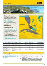
(AIM BPC) THE BAHAMAS
FirstEnergy Conference Toronto â 17-18 May 2011 - Bahamas ...
FirstEnergy Conference Toronto â 17-18 May 2011 - Bahamas ...
- No tags were found...

Create successful ePaper yourself
Turn your PDF publications into a flip-book with our unique Google optimized e-Paper software.
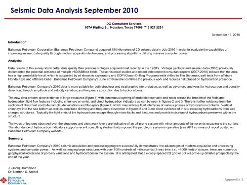
Seismic Data Analysis September 2010<br />
DG Consultant Services<br />
607A Kipling St., Houston, Texas 77006, 713 927 2251<br />
September 15, 2010<br />
Introduction:<br />
Bahamas Petroleum Corporation (Bahamas Petroleum Company) acquired 194 kilometers of 2D seismic data in July 2010 in order to evaluate the capabilities of<br />
improving seismic data quality through modern acquisition techniques, and processing algorithms utilizing massive computer power.<br />
Analysis:<br />
Data results of this survey show better data quality than previous vintages acquired most recently in the 1980’s. Vintage geologic and seismic data (1986) previously<br />
documented the potential presence of multiple >500MMboe fields. These historical studies and recent independent consultant reports (2007-2010) indicate that the area<br />
has a high probability for oil, which is supported by oil shows in exploratory and ODP (Ocean Drilling Program) wells drilled in The Bahamas, well tests from offshore<br />
Florida Keys and offshore Cuba. Bahamas Petroleum Company's June 2010 seismic confirms the previous work and reduces risk placed on hydrocarbon presence.<br />
Bahamas Petroleum Company's 2010 data is more suitable for both structural and stratigraphic interpretation, as well as advanced analyses for hydrocarbon and porosity<br />
detection, through amplitude and velocity variation, and frequency absorption due to hydrocarbons.<br />
The new data present clear evidence of large structures (figure 1) with continuous layering of probable reservoirs and seals across the breadth of the folds and<br />
hydrocarbon fluid flow features including chimneys or vents, and direct hydrocarbon indicators as can be seen in figures 2 and 3. There is further evidence from the<br />
sections of likely fluid controlled amplitude variations and flat-spots (figure 4) which may indicate fluid interfaces of various phases of hydrocarbon contacts. Vertical<br />
chimneys into the sea bottom as well as amplitude dimming and frequency absorption in figures 2 and 3 are direct evidence of in situ escaping hydrocarbons from well<br />
charged structures. Typically the light ends of the hydrocarbons escape through micro-faults and fractures and provide indicators of hydrocarbons preserved within the<br />
structure.<br />
The types of features observed over the structures and along rock layers are indicative of an oil-prone system with minor amounts of lighter ends escaping to the surface.<br />
The abundance of hydrocarbon indicators supports recent consulting studies that proposed the petroleum system is operative (see APT summary of report posted on<br />
Bahamas Petroleum Company website).<br />
Summary:<br />
Bahamas Petroleum Company’s 2010 seismic acquisition and processing program successfully demonstrates the advantages of modern acquisition and processing<br />
systems and computer power. As well as imaging large structures with over 700 hundreds of milliseconds (2-way time; i.e., ~4000 feet) of closure, there are numerous<br />
geophysical indications of porosity variations and hydrocarbons in the system. It is anticipated that a closely spaced 2D grid or 3D will prove up drillable prospects by the<br />
end of the year.<br />
J. (Jock) Drummond<br />
Dr. Norman S. Neidell<br />
Appendix 3