SOUTHERN AND EASTERN AFRICAN MINERAL CENTRE - SEAMIC
SOUTHERN AND EASTERN AFRICAN MINERAL CENTRE - SEAMIC
SOUTHERN AND EASTERN AFRICAN MINERAL CENTRE - SEAMIC

You also want an ePaper? Increase the reach of your titles
YUMPU automatically turns print PDFs into web optimized ePapers that Google loves.
Geological mapping of Area A<br />
Between 2003 and 2004 a consortium of three European companies namely the<br />
Norconsult, Norway Geological Survey and British Geological Survey, performed the geological<br />
mapping and covered 31 map sheets in Niassa and Cabo Delgado Province.<br />
Geological mapping of Area B<br />
The Geological Survey of Finland (GTK), ITC and Gondwana consortium undertook the<br />
geological mapping of 24 map sheets in Tete Province and parts of Manica, Sofala and<br />
Zambézia provinces.<br />
Geological mapping of Area C<br />
The mapping of the southern region of Mozambique was done by GTK, ITC and<br />
Gondwana from 2003 up to 2005 covering 29 map sheets.<br />
Geological mapping of Area D<br />
The South African Council for Geoscience (CGS) and the National Directorate of<br />
Geology of Mozambique (DNG) undertook the geological mapping of 12 map sheets in<br />
Nampula, Zambézia and Tete Provinces from 2001 to 2004.<br />
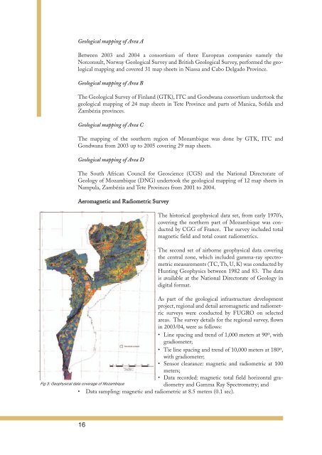
Aeromagnetic and Radiometric Survey<br />
The historical geophysical data set, from early 1970’s,<br />
covering the northern part of Mozambique was conducted<br />
by CGG of France. The survey included total<br />
magnetic field and total count radiometrics.<br />
The second set of airborne geophysical data covering<br />
the central zone, which included gamma-ray spectrometric<br />
measurements (TC, Th, U, K) was conducted by<br />
Hunting Geophysics between 1982 and 83. The data<br />
is available at the National Directorate of Geology in<br />
digital format.<br />
As part of the geological infrastructure development<br />
project, regional and detail aeromagnetic and radiometric<br />
surveys were conducted by FUGRO on selected<br />
areas. The survey details for the regional survey, flown<br />
in 2003/04, were as follows:<br />
• Line spacing and trend of 1,000 meters at 90o , with<br />
gradiometer;<br />
• Tie line spacing and trend of 10,000 meters at 180o ,<br />
with gradiometer;<br />
• Sensor clearance: magnetic and radiometric at 100<br />
meters;<br />
• Data recorded: magnetic total field horizontal gra-<br />
Fig 3: Geophysical data coverage of Mozambique<br />
diometry and Gamma Ray Spectrometry; and<br />
• Data sampling: magnetic and radiometric at 8.5 meters (0.1 sec).<br />
16