SOUTHERN AND EASTERN AFRICAN MINERAL CENTRE - SEAMIC
SOUTHERN AND EASTERN AFRICAN MINERAL CENTRE - SEAMIC
SOUTHERN AND EASTERN AFRICAN MINERAL CENTRE - SEAMIC

Create successful ePaper yourself
Turn your PDF publications into a flip-book with our unique Google optimized e-Paper software.
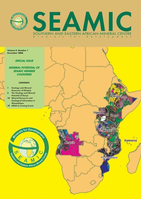
Volume 9, Number 1<br />
December 2006<br />
SSPPEECCIIAALL IISSSSUUEE<br />
MMIINNEERRAALL PPOOTTEENNTTIIAALL OOFF<br />
SSEEAAMMIICC MMEEMMBBEERR<br />
CCOOUUNNTTRRIIEESS<br />
CONTENTS<br />
1 Geology and Mineral<br />
Resources of Ethiopia<br />
5 The Geology and Mineral<br />
Potential of Kenya<br />
14 Mineral Resources and<br />
Geological Information in<br />
Mozambique<br />
19 NEWS & Coming Events<br />
<strong>SEAMIC</strong><br />
<strong>SOUTHERN</strong> <strong>AND</strong> <strong>EASTERN</strong> <strong>AFRICAN</strong> <strong>MINERAL</strong> <strong>CENTRE</strong><br />
m i n e r a l s f o r d e v e l o p m e n t
<strong>SEAMIC</strong> Newsletter<br />
Volume 9 No. 1<br />
December 2006<br />
<strong>SEAMIC</strong> Newsletter is a biannual<br />
publication of the<br />
Southern and Eastern African<br />
Mineral Centre (<strong>SEAMIC</strong>)<br />
publishing scientific, policy,<br />
information and reports about<br />
the mineral resources development<br />
related activities in<br />
the eastern and southern<br />
African sub-region.<br />
Though maximum possible<br />
check is done on the contents<br />
of articles published in<br />
<strong>SEAMIC</strong> Newsletter, any of<br />
the publications published in<br />
this Newsletter reflects only<br />
the opinion of the Author, and<br />
<strong>SEAMIC</strong> shall take no responsibility<br />
about the contents of<br />
the articles.<br />
Editor: Mesfin W. Gebremichael<br />
Editorial committee:<br />
Godfrey R. L. Nkini<br />
Elibariki C. Kimaro<br />
Lilian Moshi<br />
Design: Geo-information<br />
Department <strong>SEAMIC</strong><br />
Printer: DeskTop Publications<br />
Limited<br />
PO Box 20936<br />
Dar es Salaam<br />
Tanzania<br />
Dear Readers, the Vol. 9 No. 1 issue of <strong>SEAMIC</strong><br />
EDITORIAL<br />
NOTE<br />
Newsletter is dedicated to publishing the mineral<br />
resources potential of <strong>SEAMIC</strong> member States<br />
constituting Ethiopia, Kenya and Mozambique in an effort to introduce and promote<br />
their mineral wealth. In subsequent Newsletters the mineral potentials for the<br />
remaining Southern and Eastern African Mineral Centre (<strong>SEAMIC</strong>) member States<br />
will be addressed. In light of the above the mineral potentials of the three member<br />
States may be summarized as follows.<br />
Mozambique has a huge mineral potential that is largely untapped. Gold has been<br />
produced from the Greenstone belt and the alluvial deposits. Tantalum-niobium,<br />
other rare metals and semi-precious stones are abundant. Deposits of heavy mineral<br />
sands and a wide range of industrial minerals comprise a few of the mineral wealth in<br />
Mozambique that are under development. The government’s effort to increase the<br />
geological knowledge base through exploration for a wide range of minerals that was<br />
curtailed for a number of years in the 1980s due to the civil war in the country is now<br />
being aggressively carried out and is assisting speedy geological data collection and<br />
dissemination. This effort has significantly enabled the mineral sector development<br />
in the country and as a result many mining projects have been initiated.<br />
The earth resources of Kenya include a wide range of minerals, both metallic and<br />
industrial, as well as varieties of gemstones. The mineralisation of gold copper, silver,<br />
kyanite, corundum, graphite, wollastonite, marble, asbestos, flourspar, magnesite,<br />
kaoline, variety of gemstones, gypsum, clay, diatomite, and rare-earth elements are the<br />
few to mention. There are several exploration and mining activities underway in the<br />
country including exploration for gold and heavy mineral sand.<br />
Ethiopia is endowed with abundant mineral resources associated with the<br />
Precambrian, Paleozoic-Mesozoic sedimentary rocks, the Cenozoic volcanic and<br />
sedimentary rocks. Currently metallic minerals such as gold, columbo-tantalite and<br />
alluvial platinum and a variety of industrial minerals such as kaolin, opal, dolomite,<br />
quartz, feldspar, soda ash, dimension stones and cement mineral raw materials are<br />
produced. Rich deposits of potash, manganese and rock salt are abundant in the<br />
Tertiary/Quaternary sediments. Natural gas, geothermal energy and coal deposits<br />
have been explored at feasibility levels and are awaiting development.<br />
For more details the reader is invited to the articles presented in this Newsletter on<br />
the geology and mineral potential of Ethiopia, Kenya and Mozambique.
GEOLOGY <strong>AND</strong> <strong>MINERAL</strong><br />
RESOURCES OF ETHIOPIA<br />
BY GEOLOGICAL SURVEY OF ETHIOPIA<br />
INTRODUCTION<br />
Systematic mineral exploration in the country started in the 1970’s leading to the discovery of<br />
many metallic mineral deposits (example, gold and tantalum) and industrial raw materials for<br />
manufacturing of cement, ceramics, glass, fertilizer, etc. Exploration for fuel (natural gas and<br />
oil) and energy (coal and geothermal energy) occurrences has been conducted back in the late<br />
1940s and are still under investigation. Little is known to date about the occurrences of gem<br />
minerals, but prospecting is underway by the private sector.<br />
Systematic exploration and mining development so far undertaken in the country indicate the<br />
low-grade volcano-sedimentary assemblages as the main host rocks for precious, base, rare and<br />
ferrous and ferroalloy metals. The distribution of industrial minerals and rocks is mainly related<br />
to Precambrian metamorphic rocks, Paleozoic-Mesozoic sedimentary rocks, and Cenozoic<br />
volcanic and sedimentary rocks.<br />
Currently, mining companies are engaged in the exploration for further gold and base metal<br />
occurrences in different regions of the country. There are also several local and foreign private<br />
companies mining marble, granite, amphibolite, opal and limestone in various parts of the<br />
country. Efforts are also being made to develop the geothermal and gas energy resources.<br />
GEOLOGY<br />
The Geology of Ethiopia can be grouped into three major stratigraphic units, namely: the<br />
Precambrian basement rocks, Late Paleozoic to Mesozoic sedimentary rocks and Cenozoic<br />
volcanic and sedimentary rocks, and Tertiary/Quaternary volcanics and sediments.<br />
The Precambrian basement rocks are poly-deformed and metamorphosed high grade gneisses<br />
and schists associated with low-grade meta-volcano-sedimentary rocks. They are mainly<br />
exposed in the northern, western and southern parts of the country.<br />
Late Paleozoic-Mesozoic sedimentary rocks are widely distributed in the northern, central,<br />
eastern and southeastern parts of the country. The sedimentary rocks are unconformly overlying<br />
the basement rocks and mainly composed of sandstone and limestone and are exposed<br />
mainly in the Ogaden, Abbay and Mekele Basins. Phanerozoic sedimentary and volcanic<br />
rocks cover much of the country’s central highlands, rift valley and eastern lowlands.<br />
The Tertiary to Quaternary volcanics are associated with the evolution of the East African Rift<br />
System. The main rock types are basalts, trachytes and associated dyke swarms, andesites, rhyolites,<br />
ignimbrites and pumiceous ash.<br />
Tertiary sedimentary rocks are known in the Ogaden, in the Danakil Depression, and in the<br />
lower Omo River Valley. These rocks consist of sandstone, limestone, conglomerate, mudstone<br />
and shale. Rich deposits of potash, manganese, rock salt and other types of evaporites<br />
are abundant in the Tertiary/Quaternary sediments. Quaternary sediments occur throughout<br />
the country and were formed as lacustrine as well as marine formations. They comprise limestones,<br />
clay, siltstone, sand, volcanoclastic, and others.<br />
1
<strong>MINERAL</strong> RESOURCES<br />
Metallic Minerals<br />
Exploration and mining development activities so far undertaken in the country show the lowgrade<br />
volcano-sedimentary assemblages as the main host rock for precious, base, rare and ferrous<br />
and ferroalloy metals. Three low-grade volcano-sedimentary domains and the associated<br />
intrusives of the Arabian Nubian shield occur in southern, western and northern Ethiopia.<br />
a) Southern domain (Adola and Kenticha belts): This domain consists of the primary gold of<br />
Lege Dembi, Sakaro, Wollena, Kumuda, Megado-Serdo, Dawa-Digati, Moyale and Ababa<br />
River; the columbo-tantalite of Kenticha and Meleka and the Adola Nickel deposit.<br />
b) Western domain (Dul-Nazila, Menghi-Gizen, Fakusho-Oda and Akobo-Yubdo-Baruda<br />
belts): These belts host the primary gold of Dul, Oda-Godere, Chamo (Akobo), Baruda,<br />
Bekoji-Motish and Kilaj; Yubdo Platinum; base metals of Azali-Akendeyu, Abetselo and<br />
Kata; Fakusho molybdenite; and the iron deposits of Bikilal, Chago, Gordana and Koree.<br />
c) Northern domain (Tigray Greenstone Region and Ethiopian Rift Zone (Danakil<br />
Depression): Mafic ultramafic belts comprise the primary gold occurrences of Terakemti,<br />
Adi Zeresenay, Zager and Niraque, as well as the base metals of Tsehafi Emba.<br />
Besides these known deposits and occurrences, there exists a number of virgin exploration targets<br />
in the Precambrian terrains of southwest (Akobo belt extension), eastern (Soka series), the<br />
Melka Arba iron ore within high grade metamorphic terrain, the Chercher Malachite in the<br />
Mesozoic sandstone formations, and the Enkafela manganese in the Plio-Pleistocene conglomerate<br />
and gypsifecous units of the Danakil Formation.<br />
2
Industrial Minerals and Rocks<br />
Industrial minerals and rocks are mainly related to Precambrian metamorphic rocks, Paleozoic-<br />
Mesozoic sedimentary rocks, and Cenozoic volcanic and sedimentary rocks. These categories<br />
can be considered as a distinct domain containing a characteristics and predictable suite of<br />
industrial minerals and rocks.<br />
• The Precambrian basement domain predominantly composed of high and low grade rocks.<br />
The high-grade rocks including granites, gneissose rocks and associated pegmatites consists<br />
of Kyanite, Asbestos, feldspar, mica, kaolin, quartz, beryl and spodumene. The meta-sedimentary<br />
sequences commonly host graphite, talc, serpentinites, peridotite, and marble. The<br />
basement rocks also provide hard rocks suitable for use as blocks or in crushed form as sized<br />
coarse aggregate for construction.<br />
• The Paleozoic-Mesozoic sedimentary successions host limestone, sandstone, shale, marl<br />
and gypsum and provide significant raw materials for cement, glass and construction industries.<br />
• The Cenozoic Volcanic Rocks comprises basalts, trachytes, andesites, rhyolites, ignimbrites,<br />
pumice and scoria. The Cenozoic sediments include limestone, sandstone, conglomerate,<br />
mudstone, shale, gypsum, anhydrite, clay, siltstone, volcanoclastics and other types of evaporates.<br />
The economic importance of the Cenozoic rocks as industrial mineral resources is<br />
demonstrated by the presence of various construction materials, potash, common salt, gypsum,<br />
bentonite, diatomite, pumice, volcanogenic sulphur, etc.<br />
Energy Minerals<br />
• The sediments in Tigray in the north and in the Gambela area in the west are of potential<br />
areas for oil and gas prospects in Ethiopia and exploration for these minerals is ongoing. In<br />
the Ogaden Basin in eastern Ethiopia, past explorations indicated occurrences of oil and<br />
gas. A gas deposit of commercial value has been discovered in Calub that is at the moment<br />
under development.<br />
• There are many occurrences of coal of different ranks in different parts of the country within<br />
the sediments intercalated in the Tertiary volcanic rocks. The Yayu lignite coal deposit<br />
in southwestern Ethiopia has been studied at a feasibility level and it is under developmental<br />
stage.<br />
• The Main Ethiopian Rift and the Afar Depression are closely associated to Tertiary to<br />
recent volcanic activities. An enormous amount of geothermal energy is estimated to exist<br />
within the Rift. Pilot exploration drillings have proven the existence of steam capable of<br />
generating geothermal power in Langano and Tendaho areas in the central and northern<br />
parts of the Rift respectively.<br />
CURRENT MINING STATUS IN ETHIOPIA<br />
Gold<br />
The Lege Dembi gold mine is the only modern primary gold mine existing in the country. It<br />
is located 7 km southwest of Shakiso, a mining town about 500 km south of Addis Abeba, and<br />
is subdivided into the northern, Central and southern ore bodies. The gold is hosted in auriferous<br />
quartz veins associated with north-south trending shear zones that separate low grade<br />
rocks from high grade gneisses. The deposit has a proven reserve of 83 tons of gold at an average<br />
grade of 4 g/t.<br />
Columbo–tantalite<br />
This mine is operated by a state-owned company, Ethiopia Mineral Development Share<br />
Company (EMD), at Kenticha, about 50 km southeast of Shakiso in the Adola Greenstone<br />
Belt. A deposit in weathered crust was delineated in 1988 with proven reserves of 25,850 tons<br />
of columbo– tantalite ore at 0.02 to 0.03% Ta 2O 5. Currently, a pilot plant is producing 60<br />
tons/year of columbo–tantalite ore.<br />
3
Kaolin<br />
Kaolin is mined by EMD Share Company at Bombawha in Southern Ethiopia, about 430 km<br />
from Addis Abeba. This Kaolin is a product of in situ weathering of pegmatites and granites.<br />
The upper parts of the pegmatites and granites have been kaolinzed to a depth of 20mt. Proven<br />
reserves of 150,000 ton of kaolin had been identified in 1992, at which time open-pit mining<br />
operations began. The main consumers of its products are the Tabor Ceramics and Aluminum<br />
Sulphate Industries. The quality of the product satisfies its customers with an average Fe 2O 3<br />
content of 0.7 - 0.8%. The grade of Kaolin is 32 - 36% with a recovery of 96%. The final product<br />
has a grain size of less than 45 micrometer.<br />
Dolomite<br />
The Kenticha dolomite marble occurs north-west of the tantalum mine and extends for several<br />
kilometers in a north-south direction. The composition of the marble varies from calcite to<br />
magnesite and the grain size varies from fine to coarse. The Ethiopia Mineral Development<br />
Share Company sells its products to Modern Building Industry (MBI), a Saudi enterprise, after<br />
reducing its size to 0.1-0.3 mm by crushing. The final product is used as filler in paint, paper,<br />
and rubber industries and marketed locally and abroad. The annual production is 5,000 tons<br />
and the resource is about 1.5 million tons.<br />
Quartz and Feldspar<br />
Quartz and feldspar at Kenticha are mined as by-products of tantalum mining to be used for<br />
different applications. These industrial mineral products are consumed mainly by Tabor<br />
Ceramic Factory. The annual production is about 6,000 ton from a combined resource of one<br />
million tons.<br />
Soda Ash<br />
The Soda Ash Mine is located at Lake Abiyata in the Rift valley, about 200 km from Addis<br />
Ababa. The resource at Lake Abiyata and the neighboring lakes of Shalla and Chitu exceed<br />
460 mt of sodium carbonate at salt concentrations ranging from 1.1 to 1.9%. The plant produces<br />
about 20,000 ton/year of Soda Ash using solar evaporation harvesting system on a semiindustrial<br />
scale. The products are consumed by Caustic Soda, soap and detergent manufacturers<br />
as well as by water supply institutions.<br />
Opal<br />
Mining for opal has been going on since 1998 after exploration commenced in 1994 in the central<br />
part of the country by the private sector. Systematic exploration is underway to define bigger<br />
deposits and to look for better quality gems.<br />
Dimension Stones<br />
According to the US Geological Survey mining statistics, the production of dimension-stone<br />
in Ethiopia reached 100,000 tons in 1999 – an increase by 150% from 1995. This includes the<br />
production of granite, marble and limestone. The large increase in production was boosted by<br />
strong construction activity in the country. At present, there are several producing local and<br />
foreign private companies in Ethiopia. The National Mining Corporation (NMC), Saba<br />
Stones and Ethiopian Mining Industry (EMI) are mining marble, granite, and amphibolite and<br />
limestone in various part of the country. In addition to the local market, some of them are<br />
exporting the marble blocks to the Middle East and Europe.<br />
4<br />
Geological Survey of Ethiopia<br />
P.O.Box 2302, Addis Ababa, Ethiopia<br />
E-mail: geology.institute@ethionet.et<br />
Website:- www.geology.gov.et
THE GEOLOGY <strong>AND</strong> <strong>MINERAL</strong><br />
RESOURCE POTENTIAL OF KENYA<br />
BY MINES <strong>AND</strong> GEOLOGICAL DEPARTMENT OF KENYA<br />
GEOLOGY<br />
Geological Overview<br />
The geology of Kenya may generally be grouped into the following five major geological<br />
successions: Archean (Nyanzian and Kavirondian), Proterozoic (Mozambique Belt and<br />
Bukoban) Palaeozoic/Mesozoic sediments, Tertiary/Quaternary volcanics and<br />
Tertiary/Quaternary sediments<br />
Quaternary: Soils, alluvial beach sands, evaporates, fossil coral reefs and sandstones<br />
at the coast: alluvial and lacustrine sediments of the Rift<br />
Valley. There are also volcanic rocks of the rift valley from the<br />
younger volcanoes.<br />
Tertiary: Coastal sediments, Late Miocene and Pliocene volcanics,<br />
Terrestrial and lacustrine inland sediments. There are Early<br />
Tertiary formations not represented at surface.<br />
Palaeozoic/Mesozoic: (Cretaceous, Jurassic, Triassic, Permian and Carboniferous): The<br />
Karroo formations of the coastal hinterland, including the basal<br />
sedimentary formation in north-east Kenya.<br />
Proterozoic: Kisii series (Bukoban system): Volcanics with sediments<br />
Mozambique Belt: quartzites, biotite/hornblende gneisses,<br />
schist, granitoid gneisses, amphibolites, migmatites.<br />
Intrusives: syntectonic granites<br />
Archean: Kavirondian system: Mudstones, Sandstones, Conglomerates,<br />
Granitic intrusions<br />
1. The Nyanzian Shield<br />
Nyanzian system: Shales, cherts, ironstones, Pyroclastics,<br />
Rhyolites, Andesites, Basalts.<br />
The Nyanzian and Kavirondian systems forming the Nyanza Craton are the oldest rocks<br />
in the country with ages over 2,500 million years.<br />
The Nyanzian system is mainly composed of lavas and pyroclastics with minor sediments<br />
and banded ironstones. The Kavirondian, which rests unconformly on the Nyanzian, consists<br />
of grits, sandstones, greywackes and conglomerates. Both the Nyanzian and<br />
Kavirondian systems are isoclinally folded about axes that have an east-westerly trend.<br />
5
Kavirondian, is only slightly younger than Nyanzian but folding in the two systems has<br />
similar orientation. Numerous granitic bosses and batholiths have intruded the Nyanzian<br />
and Kavirondian. The Kavirondian intrusions were more but the pre-Kavirondian were<br />
also widespread and the two systems are discernible.<br />
2. Mozambique Belt<br />
The Mozambique belt is a structural unit within which a wide variety of meta-sedimentary<br />
and meta-igneous rocks are found showing a broad concordance of structural style and<br />
metamorphic history. In most of these rocks, the degree of deformation is intense and is<br />
of high metamorphic grades. They were thus referred to earlier in literature as the basement<br />
system rocks, due to high degree of metamorphism and deformation.<br />
Recent work on the Mozambique Belt has shown that rocks can be sub-divided into<br />
groups of contrasting lithology, structure and composition of igneous rocks content. These<br />
groups are being studied in greater detail in order to come up with proper chronostratigraphic<br />
terminology.<br />
Within the Mozambique Belt basic igneous complexes are found and range in size from<br />
bosses to small dykes. They occur both east and west of the Rift Valley. Some of the older<br />
basic intrusions have undergone deformation and metamorphism to give ortho-amphibolites<br />
and charnockitic gneisses.<br />
Basic and granitic intrusions are known in the Mozambique Belt. The most characteristic<br />
feature of the Mozambique Belt is its structural trend which is more or less north-south in<br />
its entire belt.<br />
Variations of the northerly trend are minor and, when observed, can be explained and are<br />
localised. The majority of Mozambique Belt rocks have been placed in upper Precambrian<br />
(Proterozoic).<br />
3. Palaeozoic and Mesozoic Formations<br />
Palaeozoic and Mesozoic formations in Kenya are found near the coast and in north-eastern<br />
Kenya. The earliest of these rocks are Permo-Carboniferous which are mostly sandstones<br />
and shales that form the Duruma series. This is equivalent to the Karroo system in<br />
Southern Africa. The local formations are Taru; Maji-ya-Chumvi; Mariakani and the<br />
Mazeras. They extend for about 100 kilometres from Taru to Mazeras, west of Mombasa.<br />
The rocks dip very gently towards the ocean and are heavily faulted in places.<br />
Mesozoic rocks occur in two separate areas, in the north-east part of Kenya and along the<br />
Coast belt. The stratigraphy and fossils in the two areas are very distinct and it is likely<br />
that the sedimentary basins in the two areas were connected. Revision mapping in the area<br />
has come up with interesting lithological units that have revised lithological names.<br />
4. Tertiary and Quaternary Volcanics<br />
Volcanic rocks cover the central parts of the country from south to north, occurring in the<br />
floor of the Rift Valley and on the peneplains west and east of the valley.<br />
The oldest of the volcanics are of Lower Miocene age and comprise the eroded lavas and<br />
pyroclastic piles of South Nyanza. Late in Miocene times, Kapiti and Yatta phonolites<br />
were erupted and flowed to great lengths.<br />
6
Further eruptions accompanied by faulting persisted and also gave rise to the Rift Valley<br />
and the volcanic piles of Mounts Kenya, Elgon and Kilimanjaro.<br />
Quaternary volcanism was mostly within the Rift Valley and has given rise to the craters<br />
and cider cones that are found in the floor of the valley e.g. Longonot, Menengai and<br />
Suswa.<br />
7
5. Tertiary and Quaternary Sediments<br />
There are many deposits of sediments in various parts of Kenya. They usually occur at the<br />
base of volcanic succession, intercalated with it or occurring in tectonic troughs.<br />
The repeated faulting of the Rift Valley floor and the numerous volcanic eruptions created<br />
many short-lived basins of internal drainage in which lacustrine and fluviatile sediments<br />
accumulated. Most of these sediments are unfossiliferous, but a few are of interest as they<br />
contain deposits that bear artefacts and interesting fossils that have been studied extensively.<br />
The more important sediments of middle Pleistocene are the Olorgesaillie lake beds, a<br />
lacustrine series with much diatomite, mammalian fossils and artefacts. This is also comparable<br />
to the Kariandusi sediments near Gilgil and the Kanjera Beds in the Kavirondo<br />
Gulf off Lake Victoria. Olorgesaillie beds and Kariandusi sediments are in the Rift Valley.<br />
<strong>MINERAL</strong> OCCURRENCE<br />
A wide range of minerals, both metallic and non-metallic (industrial), are known to occur<br />
in the country. These include barite, gypsum, gold, silver, lead, talc, titanium, salt, a variety<br />
of gemstones, (mainly ruby and several varieties of garnet) dimension stones, silica<br />
sand, heavy mineral sands, manganese, zinc, wollastonite, graphite, kaolin, copper, nickel,<br />
chromite, pyrite, various clays, rare earth elements and pyrochlore.<br />
The Geological environments for the mineralization can be summarised as follows:<br />
(a) The Archean Nyanzian Craton area of Western Kenya where metallic mineralization<br />
of base and precious metals are known to occur: gold, copper and silver have been<br />
mined in the past. They are also potential for ferrous and no-ferrous metals.<br />
Kimberlitic bodies have also been reported.<br />
(b) The Proterozoic Mozambique Belt that is most extensive in Central Kenya north to<br />
South in which minerals such as kyanite, corundum, graphite, wollastonite, marble,<br />
asbestos, fluorspar, magnesite, kaolin and a variety of gemstones are found together<br />
with minerals associated with basic and granitic rocks.<br />
(c) The sedimentary rocks of Palaeozoic to Quaternary are widespread. These rocks are<br />
sources and hosts of limestones, gypsum, clays, manganese and construction materials<br />
and possibly hydrocarbons. Base metal mineralization, lead-zinc-barite and copper<br />
are known to occur in the sedimentary basin along the coastal belt.<br />
Heavy mineral sands also occur along the coastal beach sands and recently deposits of<br />
about 3.2 billion tons of titanium bearing have been discovered.<br />
(d) The volcanic rocks associated with Rift System host a variety of minerals and construction<br />
materials. The volcano-sedimentary accumulations have deposits of clays,<br />
evaporites, trona (soda ash), diatomite, natural carbon dioxide, kunkar and gypsum.<br />
Gem quality rubies have also been discovered recently.<br />
8<br />
The geothermal fields are found in the area and some have been exploited, currently<br />
producing 57 MW of power to the national grid.
Carbonatites are known to be host of several minerals found in the Nyanzian shield<br />
area, around Lake Victoria shores and in the southern part of the coastal sedimentary<br />
basin. Mrima, one of the carbonatites known for potential of niobium and rare<br />
earth elements (REE) is found in the coastal basin, south of Mombasa.<br />
CURRENT ACTIVITIES<br />
Exploration<br />
A number of international companies, including, Tiomin, AfriOre and Kansai/Mid-<br />
Migori are currently carrying out exploration activities for gold. Tiomin Resources Inc. has<br />
recently completed exploration for heavy mineral sands and has been issued with a Mining<br />
Lease. A fiscal agreement providing for incentives has also been signed.<br />
Mining<br />
The Kenya Mining industry is dominated by production of non-metallic minerals which<br />
are mainly: soda ash (trona), fluorspar, diatomite, vermiculite, natural carbon dioxide,<br />
kaolin, barytes, a variety of gemstones, limestone and lime products including various construction<br />
materials.<br />
In the case of metallic minerals, some quantities of gold are being produced. Iron ore is<br />
produced from localised small deposits and is utilised in the manufacture of cement in the<br />
country.<br />
Production of some minerals during 2000-2005 was as follows:<br />
<strong>MINERAL</strong> Unit 2000 2001 2002 2003 2004 2005**<br />
Soda Ash MT 238,190 297,780 304,110 352,560 355,110 360,161<br />
Fluorspar* MT 100,102 118,850 85,015 80,201 117,986 97,608<br />
Crushed Refined Soda MT 382,556 207,647 474,014 576,146 600,209 640,291<br />
Salt(from Magadi) MT 16,359 5,664 18,848 21,199 26,607 26,595<br />
Carbon Dioxide Gas MT 7,744 5,645 5,662 4,614 6,757 8,723<br />
Diatomite* MT 448 441 1,333 353 330 233<br />
Gold* KGS 1,243 1,545 1,477 1,543 567 616<br />
Gemstones KGS 5,916 5,887 3,063 2,313 4,758 5420<br />
Mineral Products<br />
*Export figures ** Provisional<br />
Soda ash is produced from the mineral trona that occurs at Lake Magadi which is situated<br />
within the Great Rift Valley. The commodity is produced by the Magadi Soda<br />
Company Limited in one of the biggest known natural sources of trona in the world. The<br />
bulk of the soda ash is exported but a good deal of the commodity is used in various local<br />
industries as well. The annual production during the year 2005 was valued at US$ 38million.<br />
Trona occurs together with common salt and Lake Magadi is also a major source of crude<br />
salt.<br />
9
Fluorspar is mined to the east of the town of Eldoret within the Rift Valley system. The<br />
Kenya Fluorspar Company Limited operates the mine. The mine produces acid grade<br />
Fluorspar of which the bulk is for export.The annual production for the year 2005 was valued<br />
at US$ 14million.<br />
Diatomite is produced at Gilgil within the Rift Valley, but it is also known to occur in a<br />
number of localities within the Rift Valley system. The commodity is produced for both<br />
export and local markets. Its potential is large.<br />
Vermiculite is produced from Lodosoit which is in the northern central part of the Rift<br />
Valley Province within the pre-Cambrian rocks of Mozambique belt.<br />
Limestone and lime products are produced for the manufacture of cement and other industrial<br />
products. Cement and construction industries take the bulk of the limestone mined<br />
and quarried. Limestone, marbles and dolomites are widely occurring in the country and<br />
a large tonnage of the commodity is known to exist. Along the coastal belt, Bamburi<br />
Portland Cement Company Limited exploits kunkar and crystalline limestone in the vicinity.<br />
The three cement factories, Athi River, Bamburi and East Africa Portland produce over<br />
1.5 million tonnes of cement to meet local needs.<br />
Natural Carbon dioxide associated with the rift system, is exploited in a number of places<br />
and has been marketed by Carbacid (CO 2 Mfg) Limited for industrial purposes. Other<br />
Industrial Minerals exploited include gypsum which is mined in Tana River in the Coastal<br />
belt, Kajiado near Nairobi and in Turkana in North Western Kenya. Gypsum is mined and<br />
supplied to local cement plants and some is exported to Uganda<br />
Kenya boasts of a wide range of coloured and ornamental stones of gem quality, which are<br />
mined in the country. These mainly include, in order of importance, ruby, tsavorite, sapphire,<br />
various types of garnet, peridot, tourmaline, aquamarine and others.<br />
Lead was being produced from galena, which was being mined in small quantities in the<br />
coastal belt, where it was smelted together with scrap lead to manufacture lead batteries.<br />
Gold is known to occur in a number of places in gold bearing greenstone rocks of Nyanzian<br />
Craton in Western Kenya. Areas with alluvial gold are being harvested by local miners<br />
through conventional panning in the northern part of the country.<br />
Titanium and zirconium production<br />
Substantial deposits (3.2 billion tonnes) of mineral sands containing ilmenite, rutile and<br />
zircon along the Kenyan Coast have been established through exploration work by Tiomin<br />
Resources Inc. of Canada. These deposits occur in Kilifi, Kwale, Mambarui and Vipingo<br />
areas. Tiomin is focusing first on the Kwale deposit owing to its higher grades of the minerals.<br />
The mineralized sand deposits in Kwale amount to 200 million tonnes which is approximately<br />
6% of the total identified deposits in the Coast Province. Tiomin will mine about<br />
140 million tonnes that are economically recoverable out of the 200 million tonnes over a<br />
period of 14 years. The value of minerals to be extracted at Kwale over this period is<br />
approximately US$ 695 million. During the first 6 years output would be more than<br />
330,000 tonnes ilmenite, 75,000 tonnes rutile and 37,000 tonnes zircon per year.<br />
10
Tiomin estimates that it will spend US$ 150 million in construction of the project facilities<br />
and another US$ 415 million as operating costs during the project’s 14 years life span.<br />
During the first 5 years of production the Government will receive approximately US$ 2.5<br />
million as royalty per year and is expected to increase thereafter. The Government will also<br />
receive income tax, corporate tax and other taxes. In addition the project will contribute<br />
to GDP growth.<br />
During its construction phase the project would create about 1,000 direct jobs with additional<br />
employment in the operational phase. A further 1000 jobs would be created indirectly<br />
through sub contracting and provision of goods and services to the project.<br />
The project would expend about US$ 20 million in Coast Province alone every year. Out<br />
of this US$ 2.0 million will be for salaries and wages. In addition the company will improve<br />
infrastructure and construct social amenities in the area. At the resettlement site, Tiomin<br />
will construct two primary schools, two secondary schools, two dispensaries, one health<br />
centre, two social halls, water supplies at each settlement village and relocate and built<br />
churches and mosques that exist at the mine site.<br />
The Company is expected to start the construction phase of the Kwale Project this year<br />
after the compensation and resettlement issues have been completed. Production is to<br />
commence in 2007.<br />
Mineral commodities contributed about one per cent of the Gross Domestic product<br />
(GDP). However, there exists tremendous potential that awaits exploitation. Investors are<br />
expected to take up the opportunity presented to them in the form of favourable fiscal<br />
reform to invest in mineral exploration and mining.<br />
DATABASE<br />
Geological Information<br />
About 90% of the country has been covered by geological mapping at reconnaissance and<br />
regional level. Some areas are covered by mapping of 1:50,000, 1:125,000 and 1:250,000<br />
scales.<br />
The reports and maps are available for sale at the Mines and Geological Department<br />
Library in Nairobi, Kenya.<br />
Other maps available are:<br />
∗ Geological Map of Kenya (1:3,000,000), 1996 edition<br />
∗ Geological Map of Kenya (1:1,000,000), 1983 edition with:<br />
(a) Structural contours<br />
(b) Gravity lines<br />
∗ Geological Map of Kenya (1:1,000,000), 1987 Edition<br />
∗ Kenya Mineral Deposits (1:3,000,000), 2000 Edition.<br />
∗ Tectonic Map 1:3,000,000<br />
Geological mineral exploration and mining data, gathered since the turn of the century are<br />
available at the Mines and Geological Department’s archives and library, at the<br />
11
Headquarters in Nairobi. The information is currently being computerized and digitised<br />
for easy retrieval.<br />
Geophysical Data<br />
Since 1970’s several areas have been covered by airborne geophysical surveys in search of<br />
minerals. Information on the main airborne surveys can be obtained from the Mines and<br />
Geology Department.<br />
The available geophysical data will be of interest to the investors who wish to have test surveys<br />
prior to planning large scale exploration programmes. However, the existing geophysical<br />
data is not computerized.<br />
Geochemical Data<br />
Geochemical exploration has been conducted in several parts of the country in varying<br />
degrees. All areas mapped after 1970 had reconnaissance geochemical survey conducted<br />
along with the mapping. This involved collection of stream sediments, heavy minerals and<br />
grid soil samples. Geochemistry has been conducted in areas of revision mapping and<br />
ground geophysical programmes. A large part of the country has been covered by this type<br />
of geochemical data and is available at the Department’s library and archives.<br />
Topographical Maps<br />
Maps of scale 1:250,000 cover the whole country while scale 1:100,000 and scale 1:50,000<br />
are available for most parts of the country. Dates of publication do vary.<br />
Aerial Maps<br />
Most part of the country is covered by aerial photographs of varying scales and dates of<br />
coverage.<br />
Laboratory services and related Utilities<br />
∗ The Mines and Geological Department has facilities for chemical, mineralogical and<br />
petrographic analysis, fire assay and ore dressing at a nominal cost.<br />
∗ The nuclear Centre at the University of Nairobi offers analytical facilities at a cost.<br />
∗ The Mines and Geological Department offer drilling services at a cost. There are<br />
other companies in the country that offer drilling service on commercial basis.<br />
MINING OPPORTUNITIES<br />
There exist high mineral potential areas i.e. the gold bearing greenstone belt of Western<br />
Kenya and Mozambique Belt in Central and Southern Kenya. Several exploration companies<br />
have been granted exploration licenses to explore for gold and base metals in these<br />
areas. Some of the above high mineral potential areas have been staked by both local and<br />
foreign companies. Investors may wish to enter into joint ventures with companies already<br />
holding exploration concessions.<br />
Kenya has a well developed transport and communications system, which is progressively<br />
being improved and modernized to meet the needs of the expanding economy. A well-<br />
12
developed road and air network, seaports, posts and telecommunication facilities provide<br />
back-up to industrial development.<br />
The Permanent Secretary<br />
Ministry of Environment and Natural Resources<br />
P. O. BOX 30126<br />
NAIROBI - Kenya.<br />
Tel: 254-20- 2730808<br />
CONTACTS<br />
Commissioner of Mines and Geology<br />
Mines and Geological Department<br />
P. O. BOX 30009<br />
00100 NAIROBI - Kenya.<br />
Tel: 254-20-558034/558782/557672<br />
E-mail address: cmg@bidii.com<br />
The Mines and Geological Department, within the Ministry of Environment and Natural<br />
Resources, is charged with the responsibility for Mineral Resources Development,<br />
Geological Surveys and Research.<br />
call for contributions<br />
Research articles (including Photos), Tips, Views and Comments<br />
are welcome to the next<br />
<strong>SEAMIC</strong> Newsletter Volume 10, Number 1<br />
Deadline for the submission of your manuscript is<br />
1st May 2007<br />
For further Information contact: Geo-information Department<br />
<strong>SEAMIC</strong> P.O. Box 9573, Dar es Salaam, Tanzania<br />
Tel: 255 22 2650321/47, Fax: 255 22 2650319<br />
e-mail: mesfin@seamic.org<br />
13
Introduction<br />
About two-third of Mozambique, including the inland areas in the north are underlain by<br />
igneous and metamorphic rocks of Archean to Neoproterozoic age. Phanerozoic terrains<br />
are found south of the Zambezi valley and along the coastal belt in the northeast.<br />
Archean and Paleoproterozoic terrains are an extension of the Zimbabwe Craton and its<br />
supracrustal, but also include granitoids, gneisses and migmatites of the Barue Complex.<br />
Two main orogenies are recognised, the Iumide belt (1800-1350 Ma) in the northwest and<br />
the Ubiquitous Mozambique Belt (1100-850 Ma), with evidence of extensive migmatisation<br />
and granitisation as well as various granitoids and supracrustals; together these terrains<br />
constitute about 90% of the Precambrian rocks of<br />
Mozambique. The Neoproterozoic Cycle (800-410<br />
Ma) is marked by the the formation of the small platform<br />
basins, as well as the influence of the Pan-African<br />
(Katangan) orogeny in the northwest, and by the<br />
emplacement of monzonites, syenites, granites and<br />
pegmatites. Carboniferous to upper Jurassic rifting<br />
associated with sedimentation and widespread igneous<br />
activity led to numerous intercratonic Karroo basins,<br />
followed by Post-Karroo continental deposits and volcanics,<br />
as well as Meso-Cenozoic continental and<br />
marine deposits, and a thick Plioctocine and<br />
Quaternary cover.<br />
Fig 1: Mineral and rock deposit map of Mozambique<br />
Geological Mapping<br />
<strong>MINERAL</strong> RESOURCE <strong>AND</strong> GEOLOGICAL<br />
INFORMATION IN MOZAMBIQUE<br />
BY NATIONAL DIRECTORATE OF GEOLOGY OF MOZAMBIQUE<br />
The economic mineral potential is largely untapped.<br />
Gold has been produced from the Archean Manica<br />
Greenstone Belt and various alluvial occurrences; large<br />
BIF deposits are also known in this terrain. Numerous<br />
pegmatite fields host important deposits of tantalumniobium,<br />
rare earths and semi-precious stones. In<br />
addition, heavy-mineral sands, graphite, flourite,<br />
apatite, bauxite, dimension stone, various clays, sands,<br />
refractory minerals, limestone, coal and natural gas<br />
form the bulk of the mineral endowment of the country.<br />
After national independence, the government of Mozambique launched an increased geological<br />
study for mineral exploration and geological mapping in the country which resulted<br />
in identification of several new mineral deposits. However, in 1983 when the civil war<br />
intensified the geological mapping and mineral exploration fieldworks were forced to be<br />
14
educed to a large extent. In 1999 the government relaunched extensive geological studies<br />
over the large parts of the country, in order to increase the geological information availability<br />
and archiving it systematically for publishing and promotional purposes. During this<br />
period the National Directorate of Geology undertook the following activities:<br />
- Geological mapping of Niassa and Manica Greenstone Belts<br />
> From 1999 up to 2000: Ngoo, Cobue and Lupilichi in Niassa Province;<br />
> From 2002 up to 2003: sheets 1437 and 1438 in Niassa-Nampula Provinces; and<br />
about 25,000 Km 2, which covered the districts of Cuamba, Metarica, Muoco,<br />
Nipepe, Ribáuè, Iapala, Malema and Mutuali;<br />
- Geological prospection in selected areas<br />
> In 1999, the field work covering 280 km 2 was directed to exploring ornamental<br />
stones in Gorongosa area and two types of rocks with economic interest were identified:<br />
* Granito negro (olivínic gabbro and dolorito) in Mfumo Domba, Monte<br />
Ndemera, Monte Nhade areas;<br />
* Granito róseo (granular granite and granitoides) in Serra Carabina and Serra da<br />
Gorongosa areas.<br />
> In 2000, the field work in Espungabera area was carried out and 297 km 2 was covered<br />
with promising areas of granito negros:<br />
* Basalto de Chinica, Monte Cibeche, Corneana de Rio Caja, Chirarue, Monte<br />
Chicono, Basalto do Monte Mangala.<br />
* Xisto Ardósio, sources of thermal water in Vira-Vira and Régulo Wilson zone.<br />
> In 2002, Tete Province was explored covering 499 km 2 with:<br />
* Granitos (negro, castanho) with economic interest in Nhatipissa, Ratoneira,<br />
Nhambia, Txisita, Buzimuana, Moatize e<br />
Catema; along Tete-Songo in Cahora Bassa<br />
region.<br />
> In 2003 the fieldwork was undertaken in Cahora<br />
Bassa and Changara Districts and granites were<br />
identified in Maroeira, Nditi, Cahora Bassa,<br />
Kadzipande and Thaka areas.<br />
- Development of Geological Infrastructure Project<br />
Geological mapping project with the aim of<br />
improving the existing geological information and<br />
acquiring new information using different methodologies<br />
is underway at present. This project has the<br />
following geological mapping tasks (see Fig 2):<br />
> Comprehensive re-mapping of areas underlain<br />
by Precambrian rocks (Areas A, B, C, and D) at<br />
a scale of 1:250,000 and selected 1:50,000 map<br />
sheets.<br />
> Revision of the geology of the Phanerozoic<br />
rocks (Area C)<br />
> Introduction of contemporary, systematic lithostratigraphic<br />
classification<br />
> Production of modern geological map coverage<br />
and explanations in digital format<br />
Fig 2: Mapping index for scale 1:250,000<br />
15
Geological mapping of Area A<br />
Between 2003 and 2004 a consortium of three European companies namely the<br />
Norconsult, Norway Geological Survey and British Geological Survey, performed the geological<br />
mapping and covered 31 map sheets in Niassa and Cabo Delgado Province.<br />
Geological mapping of Area B<br />
The Geological Survey of Finland (GTK), ITC and Gondwana consortium undertook the<br />
geological mapping of 24 map sheets in Tete Province and parts of Manica, Sofala and<br />
Zambézia provinces.<br />
Geological mapping of Area C<br />
The mapping of the southern region of Mozambique was done by GTK, ITC and<br />
Gondwana from 2003 up to 2005 covering 29 map sheets.<br />
Geological mapping of Area D<br />
The South African Council for Geoscience (CGS) and the National Directorate of<br />
Geology of Mozambique (DNG) undertook the geological mapping of 12 map sheets in<br />
Nampula, Zambézia and Tete Provinces from 2001 to 2004.<br />
Aeromagnetic and Radiometric Survey<br />
The historical geophysical data set, from early 1970’s,<br />
covering the northern part of Mozambique was conducted<br />
by CGG of France. The survey included total<br />
magnetic field and total count radiometrics.<br />
The second set of airborne geophysical data covering<br />
the central zone, which included gamma-ray spectrometric<br />
measurements (TC, Th, U, K) was conducted by<br />
Hunting Geophysics between 1982 and 83. The data<br />
is available at the National Directorate of Geology in<br />
digital format.<br />
As part of the geological infrastructure development<br />
project, regional and detail aeromagnetic and radiometric<br />
surveys were conducted by FUGRO on selected<br />
areas. The survey details for the regional survey, flown<br />
in 2003/04, were as follows:<br />
• Line spacing and trend of 1,000 meters at 90o , with<br />
gradiometer;<br />
• Tie line spacing and trend of 10,000 meters at 180o ,<br />
with gradiometer;<br />
• Sensor clearance: magnetic and radiometric at 100<br />
meters;<br />
• Data recorded: magnetic total field horizontal gra-<br />
Fig 3: Geophysical data coverage of Mozambique<br />
diometry and Gamma Ray Spectrometry; and<br />
• Data sampling: magnetic and radiometric at 8.5 meters (0.1 sec).<br />
16
Detailed airborne survey for total magnetic and gamma-ray spectrometric data was<br />
acquired in 2004/05 on 6 selected areas. Survey details were as follows<br />
• Line spacing and trend of 300 meters at 90 o , with gradiometer<br />
• Tie line spacing and trend of 3 000 meters at 000 o , with gradiometer<br />
• Sensor clearance: magnetic and radiometric at 80 meters<br />
• Data recorded: magnetic total field horizontal gradiometry and Gamma Ray<br />
Spectrometry<br />
• Data sampling: magnetic 7 meters (0.1 sec) and radiometric at 70 meters (0.1 sec)<br />
The digital gridded data set is available at DNG and consists of the following individual<br />
data grids in GEOSOFT format, gridded at 250m cell size:<br />
* Total field magnetic, reduced to the pole magnetic, calculated vertical gradient, calculated<br />
horizontal gradient, analytical signal, IGRF corrected magnetic;<br />
* Potassium %, equivalent uranium ppm, equivalent thorium ppm, natural air absorbed<br />
rate, uranium/thorium ratio, uranium/potassium ratio, thorium/potassium ratio, digital<br />
terrain model;<br />
* Line data (Magnetic): Line Number, GPS time, fiducial, date, flight, aircraft registration,<br />
GPS latitude/longitude in WGS84 , X / Y co-ordinates in UTM, magnetic raw,<br />
residual diurnal correction, magnetic levelled, radar altitude, barometric altitude, terrain<br />
elevation and<br />
* Line data (Radiometric): Line Number, GPS time, fiducial, date, flight, aircraft registration,<br />
interpolated latitude/longitude in WGS84, Interpolated X/Y co-ordinate in<br />
UTM, raw total count, raw potassium, raw uranium, raw thorium, processed potassium,<br />
processed uranium, processed thorium, radar altitude, barometric altitude, terrain<br />
elevation, temperature.<br />
Geochemical surveys<br />
The first significant geochemical exploration work was<br />
carried out by Borches. From 1970 to 1974 geochemical<br />
exploration was conducted on a broader scale,<br />
mostly by Portuguese and French teams, and by the end<br />
of 1974 about 19% of the country had been surveyed at<br />
the reconnaissance and regional levels mostly for base<br />
metals.<br />
Most of the major geochemical surveys carried out at<br />
this period were executed by private companies with<br />
technical assistance of geologists from the National<br />
Institute of Geology of Mozambique. About 270,000<br />
km 2 or 34% of the country was surveyed using various<br />
geochemical sampling methods.<br />
Most of the geochemical data was available only as<br />
hard copy maps and data tables. Original heterogeneous<br />
data (methodology, elements, missing results)<br />
had to be gathered in order to establish the use of<br />
existing information. Maps had to be scanned, georeferenced<br />
and digitized which involved considerable<br />
amount of manual work. In these surveys only base<br />
Fig 4: Status of Geochemical survey of Mozambique (2004)<br />
metals have been analysed by AAS. Gold was not<br />
analysed. New surveys with multi-element analysis generally cover only small areas.<br />
17
During the GEODESA project of <strong>SEAMIC</strong> in 1998 and 1999, different digital data sets<br />
of Manica, Tete and Zambezia Provinces were digitized, which included the following:<br />
• The sample locations including the assay (Cu, Co, Ni, Zn) of Mavita-Gogoi area in<br />
Manica Province;<br />
• Generation of Mineral Occurrence data set from the same map (commodity, type of<br />
mineralization, location and commodity number);<br />
• Digitalization of sample location points from Regional reconnaissance and follow up<br />
geochemical maps and join assay data (Cu, Co, Ni, Zn, Pb) scanned to MS Excel;<br />
• The UNDP Geochemical maps (Cu, Co, Ni, Pb, Cr, Mo, Zn) of Tete province namely<br />
Monte Caperimbeua, Rio Máuè, Cadzomba, Metengobalame, Macungua, Cacomue,<br />
Dezenza, Chitipi, Capitaciria, Namadende, Domue and Furancungo have been digitised<br />
and the data are available;<br />
• The data set from Zambezia Province done by Aquater (20 elements) was converted to<br />
MS Excel format which can be imported into any GIS package; and<br />
• Under Greenstone Belt project (Lupiliche-Metangula, Niassa province) - Geological,<br />
geochemical, stream sediment samples, rock samples and ternary maps at a scale<br />
1:50,000 have been produced and digitized.<br />
As part of Mineral Resource Management Capacity Building Project, Geochemical and<br />
Industrial Mineral Surveys (GIM) were started in March 2005 by a consortium of GTK<br />
and Gondwana Ltd. The survey is expected to be completed by the end of 2007.<br />
The project was divided into three phases:<br />
- Phase I: Compilation and synthesis of existing data (info of earlier geochemical surveys,<br />
available samples (including reanalysis), design of GDB, training, GIS)<br />
a) Scanning of the maps (map mosaics)<br />
b) Georeferencing<br />
c) On-the-screen digitizing (data tables):<br />
1) sample points<br />
2) calculating the coordinates (UTM/ WGS 84/Zone 36S - metric system)<br />
3) adding the analytical data into data tables<br />
d) the Survey Information Table (SIT); METADATA<br />
e) the Analysis Data Tables (ADT) containing the actual analytical and coordinate<br />
data (UTM/WGS 84 -Zone 36S).<br />
- Phase II: Execution of new surveys (two stages: fieldwork and training)<br />
1) regional soil sampling survey, and<br />
2) detailed soil-sampling<br />
- Phase III: Final Products (GDB with existing survey data)<br />
18<br />
National Directorate of Geology<br />
Praca 25 de Junho No. 380<br />
PO Box 215<br />
Maputo - Mozambique
New Director General<br />
New <strong>SEAMIC</strong> member<br />
Kenya officially became the seventh member<br />
of <strong>SEAMIC</strong> as of 1st July 2006 by signing<br />
and submitting to the Centre the<br />
instrument of accession. Kenya had been<br />
actively participating as observer in most of<br />
the policy organ meetings for the last several<br />
years and has also been utilising SEAM-<br />
IC facilities and services.<br />
Upgrading of <strong>SEAMIC</strong> Library<br />
News<br />
Upon successful completion of his four year term as the Director<br />
General of <strong>SEAMIC</strong>, Dr. Diamantino Pedro Azevedo left<br />
<strong>SEAMIC</strong> in June 2006. The Governing Council of <strong>SEAMIC</strong>, in<br />
its 26th regular meeting held in Dar es Salaam on 12th May 2006,<br />
appointed a new Director General, Mr. Ketema Tadesse from<br />
Ethiopia. Mr. Ketema Tadesse was the Director General of the<br />
Geological Survey of Ethiopia before he was appointed to this<br />
post. Mr. Ketema has also served as the Chairman of the Board<br />
of Directors of <strong>SEAMIC</strong> since 1998. He started his assignment<br />
as the new Director General of <strong>SEAMIC</strong> on 14th July 2006<br />
Through the financial support granted by UNESCO, <strong>SEAMIC</strong> was able to upgrade its<br />
library. The upgrading includes installation of airconditioning in the library , increasing<br />
the number of shelves, organising a reading place for users, and introducing new journal<br />
and magazine shelves. Additional books were also purchased through this support to<br />
increase the volume and variety of publications in the library.<br />
19
TRAINING<br />
Gem cutting<br />
The newly introduced gem cutting course was first held during 9-27 January 2006 to six<br />
participants from the member countries. The second one was conducted to three interested<br />
clients from 3rd to 21st April 2006. Two more gem cutting training courses were conducted<br />
from 3rd to 21st July and 30th October to 17th November 2006 with five and six<br />
participants respectively.<br />
Training participants at a gem cutting training session (left) and attending gemmology (right) training courses<br />
Gemmology<br />
The regularly delivered “Introduction to Gemmology” course continued. The 31st, 32nd<br />
and 33rd courses were conducted by the Mineralogy, Petrology and Gemmology Section<br />
during 20-24 March, 26-30 June and 20-24 November 2006 respectively. In total thirty<br />
seven participants, from Tanzania, Uganda and Kenya, attended the course. A tailor-made<br />
course for two participants was also carried out from 24 to 28 July 2006.<br />
Mineral Processing<br />
A training course on mineral processing techniques was<br />
organised jointly by the Mineral Processing and Chemical<br />
and Environmental Sections from 13 February to 24<br />
March 2006 for three participants from Uganda.<br />
A one week training course on sampling of gold and other<br />
precious metals, which was conducted by an expert from<br />
the British Geological Survey (BGS), was attended by four<br />
participants from the <strong>SEAMIC</strong> member States and one<br />
participant from Malawi. The course was organized at <strong>SEAMIC</strong> from 3 to 7 April 2006.<br />
GIS Web Mapping<br />
A training course on GIS Web Mapping<br />
and Data Standards was carried out from 6<br />
to 17 March 2006, and was facilitated by a<br />
web mapping expert from the British<br />
Geological Survey. The course included the<br />
use of open source and free software on web<br />
GIS mapping, namely Map Server, and different<br />
international standards used in web<br />
mapping. Seven participants from the<br />
member countries attended the course.<br />
20
Attachment<br />
During the month of July and August 2006 students from the Department of Chemical<br />
and Mineral Processing Engineering of the University of Dar es Salaam were on<br />
attachment for eight weeks in the Laboratory Services Department of <strong>SEAMIC</strong> for<br />
practical training. The students were able to gain experience in analytical and ore testing<br />
methods.<br />
ITC Refresher Course<br />
ITC Refresher course was organised for the second time at <strong>SEAMIC</strong>. The two weeks<br />
training course titled “Novel approaches in earth observation and geo-information science for<br />
earth scientist” was carried out by experts from the International Institute for Geo-information<br />
Science and earth Observation (ITC) of the Netherlands from 9th to 20th October<br />
2006. This course was designed for earth scientists engaged in exploration, environmental<br />
geology or reconnaissance mapping and was attended by the alumni of ITC. 21 participants<br />
from 10 African countries, namely: Botswana, Ethiopia, Kenya, Mozambique,<br />
Namibia, Sudan, Tanzania, Uganda Zambia and Zimbabwe attended the course, which<br />
was fully sponsored by the Netherlands government. The objectives of the course were:<br />
∗ To communicate on the current state-ofthe-art<br />
in earth observation, mobile GIS<br />
and digital field data capture techniques<br />
and data integration approaches;<br />
∗ To develop conceptual framework for<br />
understanding the potential new sources<br />
of information from earth observation<br />
techniques and their applicability in<br />
Earth sciences;<br />
∗ To assist in the development of strategies<br />
for data acquisition directed towards the<br />
specific need of the earth scientist;<br />
∗ Τo provide insight into where data can<br />
be retrieved and how data (field-based<br />
and earth observation data) can be integrated;<br />
and<br />
∗ To develop multidisciplinary attitude and foster creativity in analysing and solving<br />
earth science problems through the use of earth observation or geo-information technologies.<br />
CONFERENCES <strong>AND</strong> WORKSHOPS<br />
Environmental Impact Assessment<br />
A workshop on environmental impact assessment (EIA) was organized from 20 to 24<br />
February 2006 at <strong>SEAMIC</strong>. Delegates for the workshop were from Angola, Ethiopia,<br />
Kenya, Mozambique, Tanzania, Uganda and <strong>SEAMIC</strong>. The participants’ background<br />
included mining company employees, consultants, government ministries and other government<br />
bureaus. The delegates were contacted for provision of additional information on<br />
their experience and expertise, prior to the workshop, by Dr Paul Mitchell, the workshop<br />
facilitator from the British Geological Survey. Participants also made short presentations<br />
on different aspects of the EIA process in their respective national context, during the<br />
workshop.<br />
21
Integrated Resources Planning: Fostering Minerals Clusters<br />
The workshop on “Integrated Resources Planning: Fostering Minerals Clusters”, which<br />
aimed to address the capacity gaps on management of the mineral resources sector identified<br />
at the level of government institutions in Africa was held in Maputo, Mozambique<br />
from 11 to 14 April 2006. The workshop was attended by 85 participants including officials<br />
from 16 African countries.<br />
formulation.<br />
The main objectives of the workshop was to<br />
create a critical mass of informed policy<br />
makers in the sectoral ministries responsible<br />
for mining as well as in the ministries of<br />
planning, finance and economic development,<br />
raise their awareness on the potential<br />
of minerals clusters in supporting long-term<br />
economic development and growth, provide<br />
them with tools for mineral policy design<br />
and implementation, and enhance their<br />
knowledge and capacity in mineral-related<br />
subjects, which are important to create a conducive<br />
environment for mineral resources<br />
development. With focus on minerals clustering,<br />
the workshop covered economic and<br />
legal issues, as well as the process of policy<br />
The workshop was jointly organized by ECA, UNCTAD, the Southern and Eastern<br />
African Mineral Centre (<strong>SEAMIC</strong>), the Centre for Energy, Petroleum and Mineral Law<br />
and Policy (CEPMLP) of the University of Dundee, MINTEK of South Africa, DFID of<br />
UK, and the government of Mozambique.<br />
Management of Geological Surveys<br />
The Centre organised a two-days workshop<br />
on “Management of Geological Surveys:<br />
Mandate and Financing” from 8the to 9th<br />
May 2006. The workshop was facilitated by<br />
Dr. David Ovadia and Dr. David Morgan<br />
of the British Geological Survey (BGS) and<br />
was attended by Directors of the Geological<br />
Surveys of the member States and other<br />
countries in the region. The aim of the<br />
workshop was to create a forum for interaction<br />
of geological infrastructure development<br />
stakeholders to discuss the mandates<br />
of Geological Survey Organisations and<br />
what public should expect from their activities.<br />
The workshop discussed, among<br />
other things the following topics:<br />
∗ Current status of the geological surveys in Africa;<br />
∗ How can their relevance be improved and have impact on decision makers;<br />
∗ Lessons to be learnt from surveys in other continents; and<br />
∗ Capacity building efforts in the national geological surveys.<br />
22
Shareholders Agreement Conference<br />
The long awaited, ratification of the Shareholders Agreement concept has been effected by<br />
Mozambique, Tanzania and Angola. Upon the decision of the 26th Governing Council<br />
meeting, a conference was held on 27th November 2006 that constituted the representatives<br />
from member States of <strong>SEAMIC</strong>, the private sector and academic institutions to discuss<br />
on the shareholding concept and the restructuring of <strong>SEAMIC</strong> to accommodate the<br />
changes. The conference also discussed the implementation of the shareholding concept<br />
once it is approved by the Governing Council with an incentive to attract the participation<br />
of the private sector and other stakeholders to ensure financial sustainability of <strong>SEAMIC</strong>.<br />
The conference was attended by participants from geological survey organisations of<br />
<strong>SEAMIC</strong> member States and European countries, the private sector and other government<br />
institutions.<br />
MEETINGS<br />
Governing Council Meeting<br />
The 26th meeting of the Governing Council of <strong>SEAMIC</strong> was held on 12th May 2006 at<br />
<strong>SEAMIC</strong> in Dar es Salaam, Tanzania. Angola, Ethiopia, Mozambique Tanzania, Uganda<br />
and the UNECA attended the meeting. Kenya was also in attendance as observer. The<br />
Governing Council meeting was preceded by the ninth meeting of the Standing<br />
Committee of Officials, which was held from 10 to 11 May 2006.<br />
Major decisions made by the 26th Governing Council meeting included:<br />
∗ Appointment of the new Director General;<br />
∗ Approval of the Annual Report for 2005/2006;<br />
∗ Approval of the Auditors Report for 2004/2005; and<br />
∗ Approval of the Work Programme and Budget for 2006/2007.<br />
23
COMING EVENTS<br />
MEETINGS<br />
Governing Council Meeting<br />
The 27th Governing Council Meeting will be held in May 2007 in Maputo, Mozambique.<br />
Board of Directors Meeting<br />
The meeting of the Board of Directors of <strong>SEAMIC</strong> will be held in Maputo in May 2007.<br />
TRAINING<br />
Gemmology and Gem cutting<br />
• Gem cutting, polishing and treatment: 8 - 26 January, 2 - 20 April 2007<br />
• Gemmology: 19 - 23 February, 18 - 22 June 2007<br />
Chemical Laboratory<br />
• Modern Laboratory Management Methods: 5 - 9 February 2007<br />
• Environmental Technologies, 11 - 15 June 2007<br />
Mineral Processing<br />
• Preparation of pre-feasibility studies for small mining projects: 5 - 9 February 2007<br />
• Ore testing and process development: 5 - 16 March 2007<br />
• Sampling of geological materials: 9 - 13 April 2007<br />
• Use of computers for the evaluation of mineral laboratory test data: 11 - 15 June 2007<br />
Pottery and Ceramic Technology<br />
• Basic pottery/ceramic for beginners: 12 - 16 March, 16 - 20 April, 7 - 11 May 2007<br />
• Advanced pottery/ceramic technology: 12 - 16 February, 11 - 15 June 2007<br />
Geo-information<br />
• Introduction to ArcGIS: 19 - 23 February 2007<br />
• Geological map making using GIS: 19 - 23 March 2007<br />
• Applications of remote sensing in geology and mineral exploration: 16 - 20 April 2007<br />
• GIS principles and applications: 14 - 18 May 2007<br />
• Geophysical and geochemical data capture and processing: 11 - 15 June 2007<br />
WORKSHOP<br />
Workshop on Geological Services<br />
<strong>SEAMIC</strong> will organise a workshop on geological services in May 2007 in Maputo,<br />
Mozambique.<br />
24
Southern and Eastern African Mineral Centre<br />
<strong>SEAMIC</strong><br />
Training<br />
• Mineral laboratory management<br />
• Environmental analysis and Environmental<br />
Impact Assessment studies<br />
• Mineral testing methods<br />
• Gemmology and gem cutting<br />
• Geophysics, geochemistry, environmental<br />
geology and geosciences data handling<br />
• GIS and remote sensing applications<br />
• Mineral exploration and geological mapping<br />
• Resource and reserve modelling<br />
• Sampling and preparation of geological<br />
materials<br />
Grading and Certification<br />
• Gem identification, grading and certification<br />
• Diamond grading<br />
• Gem cutting<br />
• Cabochon polishing<br />
• Bead making<br />
• Bead drilling<br />
• Gemstone Enhancement<br />
• Consultancy on all aspects related to lapidary<br />
Geo-information Services<br />
• Scanning, digitizing and plotting of maps<br />
• GIS compilation and applications<br />
• Regional mineral databases<br />
• Airborne radiometric data calibration<br />
• Geophysical surveying for underground<br />
water and mineral exploration<br />
Technical Assistance<br />
• Integrated prospecting techniques for survey,<br />
geological structure, remote sensing<br />
and geophysical prospecting<br />
• Assistance for modernization of small to<br />
medium scale mining operations<br />
• Investigations on environmental protection<br />
• Geotechnical investigation<br />
• Feasibility studies for small to medium<br />
scale mining projects<br />
Your Mineral Services Provider<br />
Analytical services<br />
• Sample preparation<br />
• Wet Chemistry for whole rock analysis<br />
• Mineral beneficiation such as mineral separation<br />
and leaching<br />
• XRF and XRD analysis<br />
• Fire assay gold analysis and purification<br />
• AAS, Graphite furnace and hydride generation<br />
analysis<br />
• Rock and mineral identification<br />
• Petrological and mineralogical analysis<br />
• ICP analysis<br />
• Mercury Analysis<br />
Mineral Applications<br />
• Evaluation, product design and prototype<br />
production<br />
• Processing and upgrading<br />
• Ceramic production technology<br />
Research and Development<br />
• Evaluation of raw materials for industrial<br />
application<br />
• Optimisation of mineral recovery operations<br />
• Development of granulation system for the<br />
beneficiation of phosphate ore<br />
• Development of ceramic tableware, low<br />
tension electrical insulators and fire clay<br />
crucibles<br />
• Development of geo-database and web<br />
mapping<br />
• Development of safe methods for disposal<br />
of hazardous chemical wastes<br />
Consultancy Services<br />
• Industrial minerals application<br />
• Preparation of bankable feasibility studies<br />
for small to medium scale mining projects<br />
• Evaluation of environmental impact<br />
assessment studies<br />
• GIS data base design and development<br />
• Geo data processing and GIS system<br />
development<br />
• Mineral ground water exploration<br />
• Management of mineral wealth<br />
• Development of Mineral recovery system.
<strong>SEAMIC</strong><br />
southern and eastern african mineral centre<br />
KUNDUCHI BEACH AREA<br />
P.O.Box 9573<br />
Dar es Salaam,Tanzania<br />
Telephone: (255 22) 2650321/47<br />
Fax: (255 22) 2650319<br />
E-mail: seamic@seamic.org<br />
Website: www.seamic.org<br />
your mineral services provider