


Create successful ePaper yourself
Turn your PDF publications into a flip-book with our unique Google optimized e-Paper software.
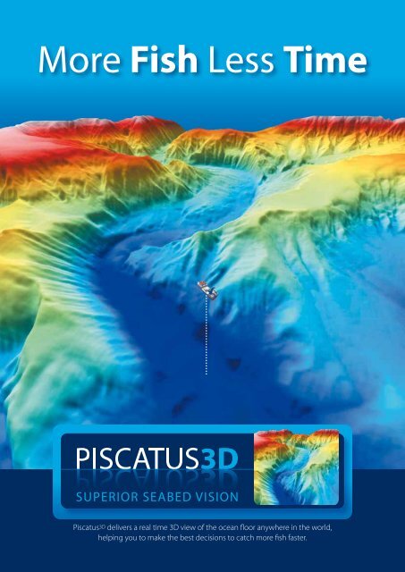
<strong>More</strong> <strong>Fish</strong> <strong>Less</strong> <strong>Time</strong><br />
<strong>Piscatus</strong> <strong>3D</strong> delivers a real time <strong>3D</strong> view of the ocean floor anywhere in the world,<br />
helping you to make the best decisions to catch more fish faster.
PIsCaTUs <strong>3D</strong> oVerVIeW<br />
<strong>Piscatus</strong> <strong>3D</strong> is a comprehensive 3-Dimensional fishing tool that displays<br />
in superior detail, exactly what is happening underwater in real-time as<br />
you fish. With an interface designed by fishermen for ease of use, view<br />
your underwater fishing grounds as never before. <strong>Piscatus</strong> <strong>3D</strong> shows your<br />
boat, the seabed, the target fish and your fishing gear. Built on a stable<br />
and reliable technology platform, <strong>Piscatus</strong> <strong>3D</strong> automatically saves your<br />
data as you fish. <strong>Piscatus</strong> <strong>3D</strong> is available in three customised applications<br />
designed specifically for your fishing operations: Inshore-Pro, DeepSea-Pro<br />
and <strong>Piscatus</strong> Classic.<br />
Inshore-Pro<br />
Inshore-Pro is designed to operate most effectively with small to medium<br />
sized vessels working in depths of up to 600M. Data collection and display<br />
in Inshore-Pro provides highly detailed <strong>3D</strong> maps for these inshore depths<br />
and allows the user to view smaller areas.<br />
DeePsea-Pro<br />
Designed for the “big boys” of the sea, DeepSea-Pro provides detailed<br />
3-Dimensional maps of the seafloor in real-time for depths well over<br />
2000M. A comprehensive data filtering and storage system provides for<br />
large amounts of data collected in greater depths. View stunning <strong>3D</strong> maps<br />
of the seafloor in real-time.<br />
PIsCaTUs CLassIC<br />
<strong>Piscatus</strong> <strong>3D</strong> Classic is designed for recreational fishing, lowering the<br />
computer specifications required from the professional versions.<br />
With <strong>Piscatus</strong> <strong>3D</strong> Classic fisherman at sea or on a lake can accurately map<br />
their favourite fishing grounds and enjoy the hunt of fishing.<br />
Latitude<br />
54˚ 29.151’N<br />
Longitude<br />
165˚ 53.613’W
FeaTUres<br />
BaThyMeTry noW<br />
BathymetryNow is a real-time dynamic mapping engine<br />
that integrates the supplied bathymetry database with GPS,<br />
echo sounding and seabed discrimination data from your<br />
vessel. As your vessel moves across the sea surface, new<br />
information is filtered, groomed, fitted and contoured,<br />
updating and refining your map to create a uniquely<br />
detailed 3-Dimensional view of what lies below. Instantly<br />
you get a much clearer understanding of already familiar<br />
grounds and a much faster appreciation of new grounds.<br />
harDness & roUghness<br />
<strong>Piscatus</strong> <strong>3D</strong> Pro versions integrate with the world’s<br />
most popular seabed discrimination devices, including<br />
RoxAnn GD, SeaScan and the JRC JFC130. With these<br />
devices and <strong>Piscatus</strong> <strong>3D</strong> you can map hardness and<br />
roughness changes in the seabed and view accurate<br />
ground discrimination in <strong>3D</strong> showing areas of mud, sand,<br />
rock, weed and many other seafloor classifications.<br />
see yoUr FIshIng gear<br />
Whether you are trawling, netting, lining or potting,<br />
<strong>Piscatus</strong> <strong>3D</strong> unique viewing angles, marks and lines enable<br />
you to easily and accurately track your vessel’s course over<br />
the fishing grounds and to mark the location of your<br />
long-lines, nets and pots in 3 dimensions.<br />
FLexIBLe PLoTTer InTerFaCe<br />
<strong>Piscatus</strong> <strong>3D</strong> can be used as a stand-alone mapping<br />
application or with an existing plotter using the built-in<br />
flexible plotter interface. This interface allows key features<br />
to be shared from your plotter using dual screens or<br />
split-screen options. Shared key features include: map<br />
location, ghost cursor, lines, marks, bathymetry contours<br />
and net position. <strong>Piscatus</strong> <strong>3D</strong> currently integrates with<br />
C-Plot Pro and SeaPlot Pro commercial plotter systems.
eaLVIeW<br />
RealView allows you to view your fishing grounds as though<br />
you are flying above the boat or swimming behind the<br />
trawl. This feature offers multiple camera views to visualise<br />
what you want to see, the way you want to see it.<br />
Zoom in or out, see the land and seabed below the surface<br />
– a real-time virtual reality.<br />
gLoBaL BaThyMeTry<br />
<strong>Piscatus</strong> <strong>3D</strong> removes the need to comprehensively cover<br />
an area to get a complete map. Missing contours are<br />
predicted and included so that you are always working with<br />
a continuous environment. Recognising that there can be<br />
errors in GPS and soundings data, <strong>Piscatus</strong> <strong>3D</strong> automatically<br />
filters erroneous data so there is no need to constantly<br />
monitor the database. Any surviving glitches can be quickly<br />
identified and deleted manually.<br />
VIrTUaLneT<br />
VirtualNet provides your net’s position in real-time<br />
using true scale net models (select from bottom trawl,<br />
mid-water or twin-rig). Enter wire and sweep lengths, set<br />
your starboard or port offset and VirtualNet displays the<br />
position of your trawl gear in relation to the seabed.<br />
Alternatively you can input these data directly from<br />
existing net monitoring equipment such as the Furuno<br />
CN22, Simrad ITI and Pacha systems. VirtualNet allows<br />
you to view upcoming subsurface obstacles before they<br />
become a problem. Even drive your net onto the fish!<br />
DaTasaFe<br />
DataSafe uses encrypted data security to enable you<br />
to fish securely in the knowledge that no one else<br />
will be able to access your valuable fishing ground data.<br />
Fully encrypted, the database will only operate on your<br />
computer. Any unauthorised removal of data will be<br />
ineffective as the data will be unusable. A component of<br />
DataSafe is FleetManager which allows you to back up,<br />
merge and share data from fishing grounds across an<br />
entire fleet. This is done safely and securely without the<br />
worry of anyone obtaining your maps or data.
ProDUCT InTegraTIon<br />
roxann<br />
<strong>Piscatus</strong> <strong>3D</strong> seamlessly integrates with the SonaVision product RoxAnn<br />
GD. RoxAnn GD uses a patented technique to extract data on bottom<br />
roughness and hardness from the first and second echosounder returns<br />
from the seabed. When integrated with <strong>Piscatus</strong> <strong>3D</strong>, RoxAnn data is displayed<br />
like never before in a detailed 3-Dimensional format for accurate and easy<br />
interpretation. See in stunning <strong>3D</strong> the roughness and hardness of your<br />
fishing grounds to help with fish location.<br />
seaPLoT Pro<br />
Integration between <strong>Piscatus</strong> <strong>3D</strong> and SeaPlot Pro allows key features to<br />
be shared from your plotter using dual screens or split-screen options.<br />
Shared key features include: map location, ghost cursor, lines, marks,<br />
bathymetry contours and net position. Recognised worldwide as a leading<br />
PC based plotting application, SeaPlot Pro has been developed with input<br />
from some of the world’s most experienced and skilled fishing skippers.<br />
sIMraD ITI<br />
Simrad ITI allows you to monitor the exact position of the gear and<br />
what is happening in and around the trawl, providing crucial information<br />
for effective, profitable and responsible fishing. When integrated with<br />
<strong>Piscatus</strong> <strong>3D</strong>, the telemetry collected from your ITI system is used to display<br />
your net position in <strong>3D</strong> providing a view of your fishing gear like you<br />
have never seen before.<br />
C-PLoT Pro<br />
Sharing key features between <strong>Piscatus</strong> <strong>3D</strong> and your C-Plot Pro plotter has<br />
never been easier. Displayed together either on split-screen formation or<br />
dual screens, with the click of a button you will see your marks, tow lines<br />
and gear position in <strong>3D</strong>. C-Plot Pro for Windows is a computer based<br />
chart display/plotting system, designed and manufactured by<br />
TMQ Electronics, Australia.<br />
I personally guarantee that <strong>Piscatus</strong> <strong>3D</strong><br />
can put more fish in your hold, faster and more<br />
efficiently than ever before<br />
George Clement, Managing Director,<br />
<strong>Piscatus</strong> Ltd, Marine Biologist,<br />
<strong>Fish</strong>eries Management Scientist.
TesTIMonIaLs<br />
reVoLUTIonary<br />
This software has revolutionised the way we fish. We see more detail<br />
than ever before and can now fish areas that we didn’t know we could.<br />
We truly do catch more fish in less time.<br />
Gary Hanson - Skipper “FV Golden Dawn” - Trident Seafoods Corp.<br />
Seattle Washington<br />
IMPressIVe<br />
The combination of <strong>Piscatus</strong> <strong>3D</strong> with Roxann is the best equipment<br />
made for fishermen since the echosounder. The <strong>3D</strong> graphics are the<br />
most impressive that I have ever seen on a fishing vessel.<br />
Skipper - 51M Long Liner - Norway<br />
aCCUraTe<br />
The best features of <strong>Piscatus</strong> <strong>3D</strong> include the ability to zoom and<br />
rotate/pan view of accurately mapped bottom features. We find this<br />
most useful when identifying sometimes subtle structure in otherwise<br />
featureless areas that hold fish and baitfish. I would recommend<br />
<strong>Piscatus</strong> <strong>3D</strong> to any keen sport fisherman or charter boat owner.<br />
Gregg Mariuz - Skipper - Profishient Charters LLC - Lake Michigan - USA<br />
soLID InVesTMenT<br />
The detail in <strong>Piscatus</strong> has helped us identify fishing grounds that we<br />
would never have fished before. A solid investment for any skipper<br />
looking to catch more fish.<br />
Peter Connolly - Skipper “FV Rehua” Sealord Group Ltd - New Zealand<br />
eFFICIenT<br />
This is the best equipment we have onboard and we earned back the<br />
cost of it in a few months. The combination of <strong>Piscatus</strong> <strong>3D</strong> and RoxAnn<br />
helps us place our nets more accurately and efficiently.<br />
Skipper - 10M Net Boat - Norway
Free DeMo DVD<br />
See the <strong>Piscatus</strong> <strong>3D</strong> software in action on this free demo DVD<br />
and learn why <strong>Piscatus</strong> <strong>3D</strong> is regarded worldwide as an essential<br />
fishing tool. This DVD will automatically play in any DVD player<br />
or DVD computer drive.<br />
Watch in amazement as our built-in bathymetry simulator creates<br />
detailed <strong>3D</strong> seafloor maps before your eyes.<br />
See high level 3-Dimensional detail like never before as this<br />
demo shows how to place your fishing gear with more accuracy<br />
and efficiency. See the simulated fishing grounds from several<br />
camera angles and viewing perspectives.<br />
Learn how you can share data between vessels in your fleet<br />
with the <strong>Piscatus</strong> <strong>3D</strong> Fleet Manager application with secure data<br />
management systems.<br />
Ask your dealer how you can learn more about <strong>Piscatus</strong> <strong>3D</strong> and how<br />
it can give you an advantage over the competition.<br />
DVD FeaTUres<br />
• Real-<strong>Time</strong> mapping simulation<br />
• Setting and retrieving gear<br />
• Trawl position simulation<br />
• Plotter Integration<br />
• Secure Data sharing<br />
www.piscatus.co.nz
TeChnICaL DaTa<br />
<strong>Piscatus</strong> <strong>3D</strong> will take information directly from a Furuno CN22/24, Scanmar<br />
Depth Sensor, Simrad ITI, NetView <strong>3D</strong>, most sounders and any GPS.<br />
Compatible with hardness/roughness output of JRC JFC130, SeaScan or the<br />
recommended RoxAnn GD system.<br />
VersIon 5.0 sUPPorTs<br />
C-Plot Pro Version 8 and up<br />
SeaPlot Pro Version 1.05 B7 and up<br />
Microsoft Windows XP, Microsoft Windows 2000 and Microsoft Windows Vista<br />
Improve your fishing experience<br />
and results with <strong>Piscatus</strong><strong>3D</strong><br />
reCoMMenDeD<br />
CoMPUTer sPeCIFICaTIons<br />
Intel® Pentium® Dual Core Processor 1.8 GHz<br />
1024 MB of DDR RAM<br />
GeForce 6 series 256MB<br />
nVidia Video Card essential<br />
80GB 7200 RPM Serial ATA Hard Drive<br />
Screen Resolution 1280 x 1024<br />
ConTaCT InForMaTIon<br />
<strong>Piscatus</strong> Limited<br />
Port Nelson<br />
New Zealand<br />
P +64 (0)3 545 7020<br />
F +64 (0)3 545 7021<br />
e info@piscatus.co.nz<br />
W www.piscatus.co.nz