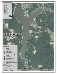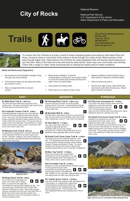
Trails
City of Rocks Trail - Idaho State Parks and Recreation
City of Rocks Trail - Idaho State Parks and Recreation
- No tags were found...

You also want an ePaper? Increase the reach of your titles
YUMPU automatically turns print PDFs into web optimized ePapers that Google loves.
City of Rocks<br />
National Reserve<br />
National Park Service<br />
U.S. Department of the Interior<br />
Idaho Department of Parks and Recreation<br />
<strong>Trails</strong><br />
City of Rocks National Reserve<br />
PO Box 169<br />
Almo, ID 83312<br />
208-824-5519<br />
www.idahoparks.org<br />
www.nps.gov/ciro<br />
To venture into City of Rocks is to enter a world of slowly changing granite surrounded by high desert flora and<br />
fauna. Access to many or most parts of the reserve is found through 22.4 miles of trail. Many sections of trail<br />
pass through fragile soils. Help preserve City of Rocks by using designated trails and leaving natural features as<br />
you find them. Many of the trails are rocky and traverse steep terrain. Snow may cover some trails until mid-May.<br />
Check with a ranger or visitor center personnel prior to entering the backcountry for latest conditions.<br />
Safety and Backcountry Regulations<br />
• Be prepared for rapid weather changes; bring<br />
rain gear and extra clothing.<br />
• Tell someone where you are going and when<br />
you expect to return.<br />
• Hike on designated trails to prevent<br />
erosion.<br />
• Backcountry sanitation: to prevent<br />
contamination of waterways, bury human waste<br />
in a hole 6-8 inches deep at least 200 feet from<br />
water. Pack out waste paper.<br />
• Carry plenty of drinking water.<br />
• Pets must be on a leash six feet or less.<br />
• Respect wildlife by observing them from a<br />
safe distance. Please do not feed wildlife.<br />
• Pack out what you pack in.<br />
• Horses have right-of-way. Step off the trail<br />
and remain quiet while horses pass. Bikers<br />
yield to horses and hikers.<br />
EASY MODERATE STRENUOUS<br />
#1 Bath Rock Trail ► 1,800 Feet<br />
This short trail loops Bath Rock beginning at the<br />
parking area. The rock is named for large natural pools<br />
of water atop this 240-foot formation.<br />
#2 Creekside Towers Trail ► .5 Miles<br />
Interesting geologic sculptures are found adjacent<br />
to the trail. This short walk provides direct access<br />
to the “Inner City” and many popular spires. Spring<br />
brings a beautiful cascade of water draining into Circle<br />
Creek visible from several areas. This trail can also be<br />
used to access the Stairways Trail (additional .5 miles)<br />
which can be used to make a loop in conjunction with<br />
South Fork Circle Creek Trail.<br />
#3 Window Arch Trail ► 300 Feet<br />
Located behind campsite #37, this short walk leads<br />
to the impressive Window Arch which spans over<br />
20 feet. Windows, bathtubs, and caves sculpted by<br />
forces of erosion, are featured along with spectacular<br />
views of the “Inner City”.<br />
#5 Flaming Rock Trail ► .5 Mile Loop<br />
Popular with many climbers, this trail provides<br />
access into the “Inner City”. Located behind campsite<br />
#32, this trail can also be used to access South Fork<br />
Circle Creek Trail.<br />
#6 Bumblie Wall ► .6 Miles<br />
Bumblie Wall is the primary access to Lost Arrow and<br />
also connects to Box Top and North Fork Circle Creek<br />
trails. Spectacular views of “Clam Shell” are featured.<br />
#7 Geo Watt ► 1.15 Miles<br />
The name “Geo Watt” refers to a<br />
complex of light bulb-like rock<br />
formations that can be seen midway<br />
along the trail. Towering “Road Map Wall” and it’s<br />
prominent white pegmatite dikes can be viewed.<br />
#8 South Fork Circle Creek Trail ► 1.5 Miles<br />
This trail serves as main street through the “Inner<br />
City.” The woodlands around the creek are home<br />
to many species of birds including Yellow Warbler,<br />
Western Tanager and Bullock’s Oriole. The varied<br />
habitats found along Circle Creek <strong>Trails</strong> provide<br />
excellent opportunities to view a diversity of wildflowers.<br />
#9 Box Top Trail ► 1.75 Miles<br />
Hikers are provided with unobstructed<br />
panoramas of Circle Creek Basin. This trail<br />
accesses Bumblie Wall Trail (additional .75<br />
miles), which can be used to create a loop.<br />
#12 Sky Line Connection ► 1.4 Miles<br />
This scenic trail climbs Graham Peak via its SW<br />
buttress to a connection with the<br />
USDA Forest Service “Sky Line”<br />
Trail. The trail provides superior<br />
views into City of Rocks and surrounding area. Alpine<br />
wildflowers abound in late May and June.<br />
#13 North Fork Circle Creek Trail ► 5 Miles<br />
Solitude is at a premium as you travel<br />
along North Fork Circle Creek. From<br />
sagebrush flats to high country aspen<br />
groves, this trail takes you deep into the “City.” Lost<br />
Horizons Arch of the Shangri La formation is the<br />
largest natural arch in the reserve, and is a highlight<br />
of the hike. This trail also provides access to Indian<br />
Grove Trail (additional 2 miles) and several panoramic<br />
vistas.<br />
WINDOW ARCH<br />
#4 Stripe Rock Trail ► 3 Miles<br />
One of the more recognizable features<br />
in the “Inner City” is Stripe<br />
Rock, so named for the aplite dike<br />
that divides the east face like a lightening bolt. The<br />
round-trip loop to Stripe Rock from Circle Creek<br />
Overlook Trailhead is 3 miles. Many other popular<br />
trails are accessed from this route: Geo Watt, Site 18,<br />
North Fork Circle Creek, Bumblie and Box Top.<br />
Bikers will find the loop more enjoyable if ridden in a<br />
counter-clockwise route.<br />
#10 Tea Kettle Trail ► 2.5 Miles<br />
Whether you start at Elephant Rock or Bread Loaves,<br />
the trail passes through varied<br />
ecosystems including aspen groves,<br />
pinon-juniper forests, and sagebrush<br />
flats. Wildlife such as mule deer, yellow-bellied marmots,<br />
and sage grouse are often seen along the trail.<br />
#11 Indian Grove Trail ► 1.35 Miles<br />
The view of 8,867-foot Graham Peak, the highest point<br />
in the reserve, is unobstructed. Legend has<br />
it that Shoshone and Bannock Indians observed<br />
California Trail emigrants from this<br />
grove of aspen and fir. The trail leads to the<br />
only designated backcountry camping area in the reserve.<br />
STRIPE ROCK<br />
VIEW SOUTH OF CITY OF ROCKS FROM GRAHAM PEAK
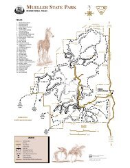
City of Rocks Trail Map<br />
0