Project Adair
Project Adair Report 2012â13 - RCAHMS
Project Adair Report 2012â13 - RCAHMS
- No tags were found...

You also want an ePaper? Increase the reach of your titles
YUMPU automatically turns print PDFs into web optimized ePapers that Google loves.
<strong>Project</strong> <strong>Adair</strong><br />
Mapping Marine Heritage Sites to<br />
Support New Marine Legislation<br />
Report for May 2012 – March 2013<br />
George Geddes
RCAHMS<br />
John Sinclair House<br />
16 Bernard Terrace<br />
Edinburgh EH8 9NX<br />
0131 662 1456<br />
info@rcahms.gov.uk<br />
www.rcahms.gov.uk<br />
Historic Scotland<br />
Longmore House<br />
Salisbury Place<br />
Edinburgh EH9 1SH<br />
0131 668 8600<br />
hs.schedulingteam@scotland.gsi.gov.uk<br />
www.historic-scotland.gov.uk<br />
Registered charity SC026749<br />
Published in 2013 by the<br />
Royal Commission on the Ancient<br />
and Historical Monuments of Scotland<br />
All images Crown Copyright © RCAHMS 2013<br />
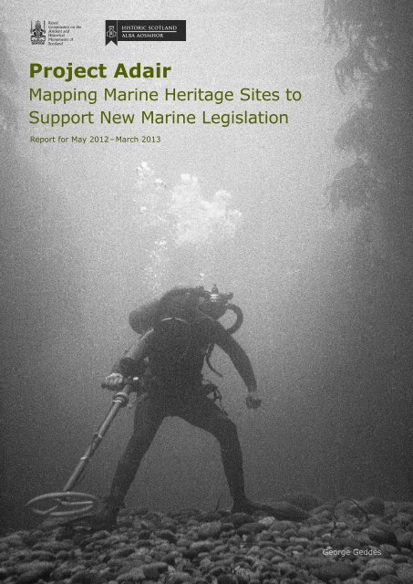
Cover image: A diving archaeologist conducting<br />
a metal-detector survey in 1974 over the site<br />
of the Dutch East Indiaman Adelaar, wrecked<br />
on the coast of Barra, Western Isles, in 1728.<br />
SC1312976 Colin Martin Collection<br />
Back cover: A bronze cannon being raised from<br />
the site of the Spanish warship El Gran Grifon,<br />
wrecked on the coast of Foula, Shetland, in<br />
1588. DP151108 Colin Martin Collection
Contents<br />
Introduction 1<br />
The Current Character of the Resource 2<br />
Summary of Results 3<br />
<strong>Project</strong> Objectives and Results 4<br />
Objective 1 4<br />
UKHO Data 4<br />
Whittaker 4<br />
Data Sharing 5<br />
Wreckmap 6<br />
Objective 2 7<br />
Orkney Waters and the Pentland Firth 7<br />
Scapa Flow 9<br />
Objective 3 9<br />
Drs Colin and Paula Martin Archive 11<br />
OHCCMAPP 12<br />
Coastal Zone Assessment Survey 12<br />
Objective 4 12<br />
Objective 4.1 12<br />
Objective 4.2 15<br />
Objective 4.3 16<br />
Conclusions 19<br />
Acknowledgements 20<br />
References and Abbreviations 21<br />
Appendix 1: Technical Methodology 23<br />
UKHO 23<br />
Whittaker 27<br />
ORCA 28<br />
Appendix 2: Statement of Requirements 29
A bronze swivel-gun with the Dutch East<br />
India company cipher, recovered from the<br />
1728 wreck Adelaar. SC1313146<br />
Colin Martin Collection
Introduction<br />
<strong>Project</strong> <strong>Adair</strong> was initiated in July 2011 as a partnership between<br />
Historic Scotland and the Royal Commission on the Ancient and<br />
Historical Monuments of Scotland (RCAHMS). Named after John<br />
<strong>Adair</strong>, the author of the Description of the Coast and Seas of Scotland<br />
published in 1703, the project sought to improve the record of the<br />
marine historic environment in a cost effective way and to ensure<br />
information is efficiently and effectively disseminated, thereby<br />
underpinning Scottish Ministers' policies for encouraging sustainable<br />
economic growth in the coasts and seas around Scotland through<br />
implementation of the Marine (Scotland) Act and UK Marine and<br />
Coastal Access Act 2009.<br />
Details on the technical methodology are outlined at the back of<br />
this report (Appendix 1). A Statement of Requirements for <strong>Project</strong><br />
<strong>Adair</strong> 2012 – 13 (Appendix 2) summarises the current policy and<br />
legislative context, and sets out priority actions that take on board<br />
the conclusions of three previous documents:<br />
• l Towards a Strategy for the Marine Historic Environment (Historic<br />
Scotland and BEFS 2009)<br />
• l Scotland's Marine Data Heritage Audit (Wessex Archaeology 2011)<br />
• l ScARF Marine and Maritime Panel Report (2012)<br />
This report sets out the results of the second and final year of the<br />
project.<br />
1
<strong>Project</strong> <strong>Adair</strong> – Mapping Marine Heritage Sites to Support New Marine Legislation<br />
The Current Character of the Maritime Dataset<br />
This table outlines the main changes in the Canmore maritime records<br />
after <strong>Project</strong> <strong>Adair</strong>. Each of the categories has been chosen to reflect<br />
particular changes in the quantity, quality and character of the record.<br />
Canmore Maritime<br />
Records Before<br />
<strong>Project</strong> <strong>Adair</strong><br />
Canmore Records<br />
After <strong>Project</strong> <strong>Adair</strong><br />
(1st April 2013)<br />
Percentage<br />
change<br />
Total number of<br />
maritime records<br />
defined by ‘site<br />
number >7,999’<br />
23,864 32,983 +38%<br />
Maritime<br />
records where<br />
‘form=wreck’<br />
Maritime<br />
records where<br />
‘form = casualty’<br />
Maritime records<br />
where ‘class =<br />
obstruction’<br />
Maritime records<br />
where ‘class =<br />
aircraft’<br />
Unlocated<br />
records ie<br />
maritime records<br />
without an<br />
entered position<br />
1,678 4,660 +178%<br />
18,447 23,587 +28%<br />
320 2,322 +625%<br />
810 1,255 +55%<br />
7,982 3,593 -55%<br />
2
Introduction<br />
Summary of Results<br />
• l 5,200 records from the UKHO Wrecks database entered into<br />
Canmore<br />
• l 18,500 records from Ian Whittaker's Off Scotland database<br />
entered into Canmore<br />
• l 600 records from the HS funded desk-based assessment of<br />
Orkney Waters and the Pentland Firth entered into Canmore<br />
• l Data from the recent HS funded Scapa Flow Survey by WA<br />
Coastal and Marine entered into Canmore<br />
• l 1,200 digital images from the Colin and Paula Martin collection<br />
accessioned and made publicly accessible through Canmore.<br />
• l Fieldwork undertaken on coastal settlements at Caolas Stulaigh<br />
and Hairteabhagh in South Uist<br />
• l All maritime archiving of reports and digital datasets is now<br />
up to date<br />
• l RCAHMS Maritime data published through the National Marine<br />
Plan Interactive<br />
• l RCAHMS working towards Medin accreditation as a Data<br />
Archiving Centre<br />
• l <strong>Project</strong> <strong>Adair</strong> ‘Wreck Map’ published<br />
3
<strong>Project</strong> Objectives and Results<br />
Objective 1<br />
To complete integration of the Whittaker database and updated UK<br />
Hydrographic Office download of wrecks data received in 2011 – 12,<br />
within the RCAHMS national inventory for the Scottish territorial waters<br />
and offshore waters (ie 0 – 200 nautical miles around Scotland) and<br />
make this information widely available to support new marine planning<br />
systems.<br />
The need to reconcile heritage information with the continually updated<br />
database of wrecks and other obstructions held by the UKHO has been<br />
highlighted previously (Historic Scotland and BEFS 2009, 10; WA Coastal<br />
and Marine 2011, 47). Addressing this need from 0 – 200 nautical miles<br />
around Scotland is considered the central aspect of <strong>Project</strong> <strong>Adair</strong> as<br />
it will ensure that there is a basic current record in place to cover the<br />
full geographic area within which Scottish Minister's devolved powers<br />
extend for planning and licensing (powers to designate Historic Marine<br />
Protected Areas extend to 12 miles only).<br />
UKHO Data<br />
The United Kingdom Hydrographic Office (UKHO) wrecks database is<br />
the most significant dataset of wrecks in UK and International waters.<br />
Developed principally with navigation in mind, it includes over 5,000<br />
entries for Scottish waters.<br />
After changes in legislation, and the resultant alteration of the RCAHMS<br />
Royal Warrant to include offshore environments in 1992, the foundation<br />
stones for a Scottish historic environment record were laid in March<br />
1995 with the integration of a download of this dataset into what was<br />
then the National Monuments Record of Scotland database, amounting<br />
to about 1,500 records.<br />
As part of <strong>Project</strong> <strong>Adair</strong>, an updated and more complete version of<br />
the UKHO dataset including over 5,200 records was integrated with<br />
Canmore in March 2013. The details of the methodology used can be<br />
found in Appendix 2.<br />
Whittaker<br />
Whittaker's Off Scotland is the single most important reference of<br />
maritime losses (shipping and aircraft) in Scottish waters. Because of<br />
its significance, the process of manually referencing recording the book,<br />
linking it to Canmore records and entering the relevant details, was<br />
begun in 2007. This methodology was also applied to other key texts,<br />
such as Larn and Larn's Shipwreck Index of the British Isles, and Ridley's<br />
4
<strong>Project</strong> Objectives and Results<br />
Dive Guides, and was closely related to that used by the Ordnance<br />
Survey Archaeology Division's Office Recorders. The process included a<br />
manual concordance and a peer review of the combined dataset.<br />
With the retiral of RJC Mowat from RCAHMS in 2012, and the timely<br />
accession of the revised digital database of losses that lies behind<br />
Whittaker's Off Scotland, it was decided that a) the remainder of the<br />
Whittaker dataset should be input through a programmed process<br />
(with manual checking and peer review), and b) that the entire digital<br />
database (including all the original fields, unaltered) should be entered<br />
into Canmore. As part of <strong>Project</strong> <strong>Adair</strong> the entire Whittaker database of<br />
over 18,000 records was integrated with Canmore in March 2013. The<br />
details of the methodology used can be found in Appendix 2.<br />
Data Sharing<br />
Canmore data is available to view and interrogate through the<br />
Canmore and related websites (such as Pastmap), which allow detailed<br />
database and spatial searching. Canmore maritime data, including<br />
wrecks, losses and all records within 150 m of the high water mark,<br />
is available through Scottish Government's National Marine Planning<br />
Interactive.<br />
Extracts of the dataset including downloads and GIS shape files can be<br />
ordered through http://www.rcahms.gov.uk/buy-images-and-data.html<br />
5
<strong>Project</strong> <strong>Adair</strong> – Mapping Marine Heritage Sites to Support New Marine Legislation<br />
Wreckmap<br />
The concept of exploring the potential for shipwreck archaeology in<br />
Scottish waters through density mapping of historic losses to shipping<br />
was explored in the first project report. A ‘Wreck Map’ generated from<br />
Whittaker's record of losses in Scottish Waters was published online<br />
in March 2013 (RCAHMS 2013). The map, designed to be viewed<br />
onscreen or printed out at A3, gives an indication of the high density<br />
of shipwrecks around Scotland's coast, and the particular potential of<br />
historically important areas of shipping and dangerous routes. The map<br />
itself includes a detailed description of the methodology used.<br />
<strong>Project</strong> <strong>Adair</strong> Wreck Map<br />
This map shows the ‘density’ of ship and aircraft losses in Scottish waters, giving<br />
a clear sense of the historical importance of particular ports and harbours (such as<br />
Aberdeen, Stornoway and Scapa Flow); of shipping routes (such as the Sound of<br />
Mull and the Firth of Clyde); and of navigational hazards (such as Fife Ness or the<br />
Mull of Kintyre). The map also gives a broad sense of the potential for discoveries in<br />
different parts of Scotland’s waters – although survival of sites will be conditioned<br />
by many other complex factors.<br />
These density values have been generated from Whittaker’s Off Scotland record of<br />
maritime and aviation losses in Scottish Waters, published in 1998. This dataset<br />
was collected using a consistent methodology and remains the most comprehensive<br />
publication of this information. The data includes vessels built as recently as 1992,<br />
as well as losses of shipwrecks reported from as early as AD800. The methodology<br />
is described in full in the preface to the book.<br />
Whittaker’s records have been sifted to remove those assigned generalised locations<br />
(eg ‘off the Hebrides’, or ‘off the west coast’), amounting to about 10% of the total.<br />
Even so, in the case of most losses the location is still not accurate, though not<br />
entirely arbitrary, for example ‘10 miles E of Aberdeen’, or ‘on the Bass rock’.<br />
This map has been produced as part of <strong>Project</strong> <strong>Adair</strong>, an RCAHMS project funded<br />
by Historic Scotland. The map is made of thousands of cells each measuring 50m<br />
square. A kernel density has been generated for each cell by working out how many<br />
wrecks lie within a specific radius, giving a value (between 0 and 7.4) that equates<br />
to the number of losses in each 100km². Please note that located sites exist in<br />
areas without colour coding.<br />
For information on located wrecks and other seabed obstructions,<br />
please refer to Canmore (rcahms.gov.uk) or the charts of<br />
the UK Hydrographic Office.<br />
www.rcahms.gov.uk/rcahms-projects/project-adair<br />
6
<strong>Project</strong> Objectives and Results<br />
Objective 2<br />
To integrate within the RCAHMS National Inventory, data and<br />
information gathered in 2011 – 12 as part of <strong>Project</strong> <strong>Adair</strong> by Orkney<br />
Research Centre for Archaeology (ORCA), and by Wessex Archaeology<br />
(site surveys in Scapa Flow) in order to enhance the record for the<br />
Orkney Waters and Pentland Firth and to make this information widely<br />
available to support new marine planning systems;<br />
• l Integration into Canmore of information from database provided<br />
by ORCA to RCAHMS<br />
• l integration into Canmore of site information from Wessex<br />
Archaeology report into the survey of high priority sites in<br />
Scapa Flow<br />
Orkney Waters and the Pentland Firth<br />
A pilot desk-based project was undertaken to revise and enhance<br />
the historic environment record for Orkney waters and the Pentland<br />
Firth. Undertaken by the Orkney Research Centre for Archaeology,<br />
the project board included representatives from Orkney and Highland<br />
Council.<br />
The project resulted in the creation of 577 notes describing 462 new<br />
sites and 115 existing sites, each of which was designed with relevant<br />
fields so that it could be directly imported to Canmore. The results<br />
were provided as a text report, two databases, and two shapefiles. The<br />
details of the methodology used can be found in Appendix 1, and in the<br />
project report available online.<br />
The project was particularly valuable in the compilation and<br />
archaeological analysis of recent survey data, which produced an<br />
amended dataset rich in geophysical anomalies which may be of<br />
archaeological significance. The project plan, which included a detailed<br />
project design allowing the results to be easily entered into Canmore<br />
with site-area polygons was also a very positive and unusual aspect.<br />
The original dataset supplied to ORCA included 9986 located records<br />
for the project area (of which 1,620 were maritime). Information on<br />
1,286 unlocated records (ie those assigned a map sheet but not a grid<br />
reference) was also supplied.<br />
The 462 new records presented a significant increase in the overall<br />
maritime dataset but over 344 of these were classified as ‘Unidentified<br />
7
<strong>Project</strong> <strong>Adair</strong> – Mapping Marine Heritage Sites to Support New Marine Legislation<br />
Extract from the survey<br />
data for four wrecks in<br />
Mill Bay, Orkney: from<br />
front to back, MV Mara,<br />
KMS F2, YC21, HMS<br />
Dewey Eve. Extracted by<br />
RCAHMS from © Historic<br />
Scotland data.<br />
Object’, and it is difficult to verify the value of the increase, and the<br />
character and origin of these objects, without field checking (ie more<br />
detailed archaeological survey of some form). Characterisation of areas<br />
as anchorages and fishing grounds in specific periods was also of great<br />
use, and it raises a number of questions about how these areas are<br />
recorded going forward. Finally, the project benefited greatly from local<br />
contact with divers who were able to clarify the specific character if<br />
otherwise unknown obstructions.<br />
The large area approach to maritime record upgrade has also been<br />
tested and, although it was possibly to study available survey data,<br />
it was not possible to undertake a complete ‘record revision’ of<br />
the dataset of c2800 maritime records (unlocated and located) in<br />
the available timescale. Record revision on that scale is something<br />
that takes many years and has, in the past, been undertaken by<br />
organisations such as the UKHO and the OS Archaeology Division.<br />
8
<strong>Project</strong> Objectives and Results<br />
Scapa Flow<br />
WA Coastal and Marine were commissioned by Historic Scotland to<br />
provide high-resolution multibeam survey data targeted on a number<br />
of known wreck sites in Scapa Flow. A total of eighteen wrecks were<br />
surveyed and assessed, including 16 that were previously known.<br />
The text report was accessioned into the collection in 2012 and made<br />
available as a pdf linked to individual Canmore records. The digital<br />
archive, 157 files amounting to 2 GB of data, is held on secure servers<br />
at RCAHMS and is to be accessioned and catalogued in partnership with<br />
WA Coastal and Marine once metadata has been created.<br />
Extract from the survey data for four wrecks in Mill Bay, Orkney: from<br />
front to back, MV Mara, KMS F2, YC21, HMS Dewey Eve. Extracted by<br />
RCAHMS from ©Historic Scotland data.<br />
Objective 3<br />
To work collaboratively with third parties supported by Historic Scotland<br />
to carry out further priority data gathering/archiving work. The objective<br />
for RCAHMS is to ensure that this information is archived within the<br />
RCAHMS National Inventory and made widely available to support new<br />
marine planning systems.<br />
• l Any data requested from RCAHMS by the third parties will be<br />
provided free of charge<br />
• l RCAHMS will participate in project steering groups (by video<br />
conference where appropriate)<br />
• l RCAHMS will coordinate with third parties to ensure that data/<br />
collection material generated is developed and delivered in a manner<br />
that allows for assimilation within the national inventory/collection<br />
through RCAHMS data structure deposition mechanisms<br />
• l RCAHMS will undertake a 10-day field trip with Wessex Archaeology<br />
as part of the Outer Hebrides Coastal Community Marine Archaeology<br />
Pilot <strong>Project</strong> (OHCCMAPP)<br />
9
10<br />
Colin Martin prepares for his first exploratory<br />
dive in Stroms Hellier on 11 May 1970. The<br />
wreck of the 650 ton 38-gun Armada ship<br />
El Gran Grifón was discovered on the 9th<br />
June. Colin Martin Collection. DP151104
<strong>Project</strong> Objectives and Results<br />
Drs Colin and Paula Martin Archive<br />
Historic Scotland commissioned Morvern Maritime Centre to carry out<br />
a project under the auspices of <strong>Project</strong> <strong>Adair</strong> entitled ‘Digitising and<br />
archiving the Colin Martin Collection of maritime material in the National<br />
Monuments Record of Scotland’.<br />
The project involved a close partnership between Colin and Paula Martin,<br />
and RCAHMS, which facilitated the creation of a long-term copyright<br />
agreement, the development of a detailed methodology for ‘selfdigitisation’<br />
and the integration of c1200 high resolution digital images<br />
of line drawings, and transparency and print photographs. The collection<br />
includes a large amount of unpublished primary material that captures<br />
a number of the most important shipwreck excavations of the 20th<br />
century (Martin 1998 provides a summary of these major excavations).<br />
Site Numlink Material Size Accessioned &<br />
Catalogued<br />
Adelaar 213275 156 digital images<br />
(colour and black and<br />
white images, line<br />
drawings)<br />
Dartmouth 102424 683 items including<br />
photographs and<br />
drawings<br />
7.25 GB Yes<br />
34.3 GB Yes<br />
Siccar Point 151710 2 line drawings Yes<br />
75 – 95 Perth<br />
High Street<br />
[medieval]<br />
28257,<br />
160087,<br />
160592<br />
28 items including<br />
drawings and<br />
photographs<br />
1.01 GB Yes<br />
Duart Point 80637 20 line drawings Yes<br />
Boathouses Various 130 items including<br />
line drawings and<br />
photographs<br />
8.07 GB Yes<br />
El Gran<br />
Grifon<br />
3857 141 items including<br />
black and white<br />
images, colour<br />
images, and line<br />
drawings<br />
6.35 GB Yes<br />
11
<strong>Project</strong> <strong>Adair</strong> – Mapping Marine Heritage Sites to Support New Marine Legislation<br />
OHCCMAPP<br />
A ten-day fieldtrip was undertaken with colleagues from WA Coastal and<br />
Marine. This included field survey (undertaken by RCAHMS), as well as<br />
paleogeographal sampling and diver survey (undertaken by WA). The<br />
two areas visited by RCAHMS were both on the remote east coast of<br />
South Uist, at Hairteabhagh and Caolas Stulaigh. The results of RCAHMS<br />
fieldwork are presented below (Objective 4.3) and summarised in the<br />
project report by WA Coastal and Marine (2013 forthcoming).<br />
Coastal Zone Assessment Survey<br />
Building on last year, further efforts were made to enhance Coastal Zone<br />
Assessment Survey (CZAS) data in Canmore, focussing this time on the<br />
Western Isles, and in particular Barra and Vatersay. This supports the<br />
priority work of <strong>Project</strong> <strong>Adair</strong> on Orkney's maritime inventory, the areas<br />
subject to study in 2012.<br />
Objective 4<br />
To upgrade records for existing designated underwater sites and other<br />
key coastal and marine sites, including digitisation of archaeological<br />
reports and other material and to make this information widely available<br />
to support new marine planning systems<br />
• l Obtain and digitise copies of Wessex Archaeology designated/<br />
undesignated site assessments and other reports<br />
• l Digitise other collection material within the RCAHMS collection where<br />
appropriate, in discussion with Historic Scotland<br />
• l Enhance and improve the record of sites discovered during the Outer<br />
Hebrides Coastal Community Marine Archaeology Pilot <strong>Project</strong> and<br />
related projects (in liaison with Western Isles Council Archaeology<br />
Service)<br />
Objective 4.1<br />
A considerable amount of fieldwork has been funded by Historic Scotland<br />
in relation to the administration of the Protection of Wrecks Act (1973)<br />
and to their broader responsibilities. The full paper and digital archives<br />
from these projects undertaken by WA Coastal and Marine will be<br />
deposited with RCAHMS in due course, and the majority of the projects<br />
are now at least partially archived. The table below illustrates the state<br />
of the archive: whether there is a paper copy of the report (Manuscript<br />
or MS), whether there is a digital copy of the report (WP – downloadable<br />
12
<strong>Project</strong> Objectives and Results<br />
pdf), and whether additional digital material has been deposited with<br />
RCAHMS ie geophysical datasets. One example of the later is the<br />
Campania digital archive that amounts to 2.5GB of data held in 34 files.<br />
RCAHMS<br />
Numlink<br />
Digital<br />
Report<br />
Paper<br />
Report<br />
Additional<br />
digital data<br />
Tobermory Galleon 22320 WP000724 MS2784 Multiple files<br />
Dartmouth 102424 WP000725 MS2779<br />
Duart Point 80637 WP000726 MS2780<br />
Mingary Castle 167515 WP000728 MS2783<br />
Iona 1 102456 WP000733 MS5899<br />
Campania 96655 WP000730 MS2785 Multiple files<br />
Burntisland 147079 WP000729 MS2786 Multiple files<br />
Scapa Flow (Area) Multiple WP000538 In process<br />
Kennemerland 1401 WP000754 MS2782<br />
De Liefde 102891 WP000727 MS2781<br />
Siccar Rock 151710 WP000743<br />
Drumbeg HMPA 320244 WP000731<br />
OHCCMAPP<br />
2011 – 2012<br />
Multiple<br />
WP000755<br />
General (Aircraft<br />
Crash Sites at Sea)<br />
Multiple<br />
WP000517<br />
General<br />
(Characterising<br />
Scotland's Marine<br />
Archaeological<br />
Resource)<br />
Multiple<br />
WP000720<br />
General (Transition to<br />
Historic MPAs)<br />
Multiple<br />
WP000732<br />
13
14<br />
The wreck of the Armada ship El Gran Grifon,<br />
wrecked on Fair Isle in 1588. Archaeologist<br />
Andrew Fleming uncovers a cannon as he<br />
removes shingle from the main gulley 389<br />
years later. Colin Martin Collection. DP1151142
<strong>Project</strong> Objectives and Results<br />
Objective 4.2<br />
A programme of record upgrade and digitisation was undertaken for the<br />
Protection of Wrecks. This included three major strands:<br />
1. the separation of the lengthy descriptions in Canmore into separate<br />
‘events’, each with greatly improved metadata clarifying when and<br />
by whom they were written, and improved links to relevant collection<br />
material and bibliographic information<br />
2. the assessment of collection material, improvement of cataloguing<br />
information, and digitisation of key items<br />
3. the production of short summary texts to clarify the history of the<br />
vessel, its exploration and the collection<br />
RCAHMS<br />
Numlink<br />
Collections<br />
enhancement<br />
New summary<br />
Text<br />
Events<br />
Kennemerland 1401 Yes Yes Yes<br />
Wrangels Palais 71037 Yes Yes Yes<br />
Duart Point Wreck 80637 Yes Yes Yes<br />
Dartmouth 102424 Yes Draft Yes<br />
Burntisland Wreck 147079 No No Yes<br />
Mingary Castle<br />
Wreck<br />
167515 No No Yes<br />
Kinlochbervie 194560 Yes Draft Yes<br />
HMS Campania 96656 No No Yes<br />
15
<strong>Project</strong> <strong>Adair</strong> – Mapping Marine Heritage Sites to Support New Marine Legislation<br />
Objective 4.3<br />
Enhance and improve the record of sites discovered during the Outer<br />
Hebrides Coastal Community Marine Archaeology Pilot <strong>Project</strong> and<br />
related projects (in liaison with Comhairle nan Eilean Siar Archaeology<br />
Service)<br />
The results of the OHCCMAPP project have been reported annually –<br />
WA Coastal and Marine Report 79440 and 79441 (Draft). The results<br />
of the 2012 – 13 year included detailed surveys and descriptions of<br />
archaeological sites in two locations on the remote east coast of South<br />
Uist, Caolas Stulaigh and Hartebhagh, neither of which had been subject<br />
to archaeological survey before.<br />
Caolas Stulaigh<br />
The settlement at Caolas Stulaigh provided an opportunity to study a<br />
post-medieval group of buildings found in close proximity to two large<br />
fish traps. The site consisted of the remains of a pre-improvement<br />
township of at least two houses, combined with an extensive area<br />
of formerly spade-cultivated land. Overlying this was a 19th century<br />
shepherd's house and sheepfold. Documentary evidence suggests the<br />
fish traps were used by the shepherd in the late 19th century, and the<br />
An interpretative<br />
archaeological plan<br />
of the farmstead<br />
at Caolas Stulaigh.<br />
SC1319631<br />
16
<strong>Project</strong> Objectives and Results<br />
study area therefore provides one of the only securely dated fish traps<br />
in the Western Isles, and one that can be linked to use by the post-<br />
Improvement (ie sheep farming) land-use.<br />
Site descriptions were written up for the principal settlement as Caolas<br />
Stulaigh as well as a nearby building and two fish traps. Descriptions<br />
were also made of a new site, probably a prehistoric settlement<br />
underlying a shieling group, and another well-known souterrain. All<br />
of the descriptions are available through Canmore as is a scan of the<br />
interpretative field survey of the principal settlement, undertaken at<br />
1:500.<br />
The drawings captures the natural topography, the position of the earlier<br />
(and larger) blackhouses, and the superimposed positions of the 19th<br />
century shepherd's houses. Elements of the cultivated landscape and the<br />
system of turf dykes and drains also feature on the drawing.<br />
Hairteabhagh, South Uist<br />
The settlement at Hairtebhagh provided another opportunity to study a<br />
multi-period settlement in a maritime context. A hut circle was located<br />
inland from the bay, one of only a handful known on the east side of<br />
An interpretive plan of<br />
part of the Hairtebhagh<br />
township. Features<br />
include a fish trap, a<br />
well constructed track,<br />
lazy bed cultivation,<br />
earlier and later phases<br />
of buildings, peat stack<br />
stances, quarries and<br />
what are probably intertidal<br />
field boundaries.<br />
SC1320075<br />
17
<strong>Project</strong> <strong>Adair</strong> – Mapping Marine Heritage Sites to Support New Marine Legislation<br />
the Outer Hebrides, while another settlement mound was located to<br />
the north west. Around the bay a series of byre-houses illustrated the<br />
development of vernacular architecture with the change to shorter<br />
buildings with gable chimneys and 3-bay frontages. Two features that<br />
may have been kelp kilns were also identified, as were a suite of fish<br />
traps and field boundaries that criss-cross the bay. A small area of<br />
the hinterland behind the bay was surveyed at 1:500 to provide an<br />
indication of the character of the settlement remains. Peat cutting was<br />
also noted, as were a couple of peat stack stances.<br />
18
Conclusions<br />
<strong>Project</strong> <strong>Adair</strong> has succeeded in significantly enhancing Canmore with<br />
information about the marine historic environment from a wide range<br />
of readily available sources. RCAHMS and Historic Scotland accept<br />
that a basic and current maritime record now exists for the Scottish<br />
seas that can be updated as our knowledge continues to improve.<br />
It is hoped that Canmore can therefore provide a useful knowledge<br />
resource to aid research into our marine and maritime heritage, as<br />
well as public appreciation and understanding of it. By making this<br />
information available to heritage curators, planners, developers and<br />
their consultants, it is also hoped that Canmore can provide a valuable<br />
information tool to aid the sustainable management of the Scottish<br />
Marine Area under Scotland's new marine planning and protection<br />
system.<br />
A distribution map<br />
showing maritime<br />
records in Canmore<br />
before <strong>Project</strong> <strong>Adair</strong> –<br />
light blue – and after<br />
the data upgrade –<br />
dark blue.<br />
19
Acknowledgements<br />
<strong>Project</strong> <strong>Adair</strong> was funded by Historic Scotland, and thanks are due to<br />
Philip Robertson in particular. This report was written by George Geddes<br />
and edited by John Sherriff, Robin Turner, and Philip Robertson. Design<br />
and layout was by Alasdair Burns. Particular thanks are due to Hannah<br />
Smith, <strong>Project</strong> Officer for <strong>Adair</strong> for much of 2012, and to Derek Skinner,<br />
who undertook many hours of programming in order to ensure the<br />
success of the project. Emily Nimmo, digital archivist at RCAHMS, was<br />
also on hand to help with cataloguing conundrums.<br />
Partnership projects during the year included those with WA Coastal<br />
Marine, including all members of their Edinburgh office, and with<br />
Colin and Paula Martin, the cataloguing of their archive material from<br />
pioneering work in the 1970s being one of the most rewarding and<br />
exciting aspects of a busy year.<br />
20
References and Abbreviations<br />
BEFS<br />
The Built Environment Forum Scotland<br />
Historic Scotland and the Built Environment Forum Scotland 2009<br />
Towards a Strategy for Scotland's Marine Historic Environment.<br />
Available at http://www.historic-scotland.gov.uk/marine-strategy.pdf<br />
Martin, C 1998<br />
Scotland's Historic Shipwrecks, London:Batsford<br />
National Marine Planning Interactive<br />
Available at http://www.scotland.gov.uk/Topics/marine/seamanagement/<br />
nmpihome/nmpi<br />
Orkney Research Center Archaeology 2012<br />
Mapping marine heritage sites in the Orkney and the Pentland Firth.<br />
Available at http://www.rcahms.gov.uk/<br />
RCAHMS 2012<br />
<strong>Project</strong> <strong>Adair</strong>: Mapping Marine Heritage Sites to Support New Marine<br />
Legislation, Report for May 2012 – March 2013.<br />
Available at http://www.rcahms.gov.uk/rcahms-projects/project-adair<br />
RCAHMS 2013<br />
<strong>Project</strong> <strong>Adair</strong> Wreck Map.<br />
Available at http://www.rcahms.gov.uk/rcahms-projects/project-adair<br />
RCAHMS Thesaurus<br />
Available at http://canmore.rcahms.gov.uk/<br />
WA Coastal and Marine 2012<br />
OHCCMAPP Report (2011 – 12). Ref. 79440.<br />
Available at http://blogs.wessexarch.co.uk/ohccmapp/downloads/<br />
WA Coastal and Marine 2013<br />
OHCCMAPP Report (2012 – 13). Ref. 79441.01<br />
Available at http://blogs.wessexarch.co.uk/ohccmapp/downloads/<br />
Wessex Archaeology 2011<br />
‘Scotland's Marine Data Heritage Audit’. Unpublished report for Historic<br />
Scotland. Available at http://www.wessexarch.co.uk/projects/marine/<br />
scotland/historic-scotland-marine-data-audit<br />
Whittaker, I 1998<br />
Off Scotland: a comprehensive record of maritime and aviation losses in<br />
Scottish waters, Edinburgh: C-Anne<br />
21
22<br />
A diving archaeologist carrying an oak<br />
lodging-knee recovered from the wreck of<br />
the Dartmouth, wrecked in the Sound of Mull<br />
in 1690. SC1326642 Colin Martin Archive.
Appendix 1: Technical Methodology<br />
UKHO<br />
The methodology for entering the UKHO database into Canmore<br />
was summarised in the first year report, and is detailed here.<br />
It was developed in partnership between the Archaeology and<br />
Database <strong>Project</strong> Managers and the Archaeology <strong>Project</strong> Officer.<br />
The methodology was iterative and went through a number of<br />
developments over the course of the year 2012 – 13.<br />
1. Archiving the data<br />
The dataset (native format), metadata, cover letter and memorandum<br />
of agreement are catalogued in RCAHMS digital archive and linked<br />
to every affected site record. The download included the full dataset<br />
(ie records classified by UKHO as LIVE, DEAD, ABEY, LIFT), including<br />
fouls, but excluding 26 records defined as commercially sensitive.<br />
The extent of the data was delimited by the Scottish 200 nautical<br />
mile fisheries area plus a 20 mile buffer to ensure we are certain of<br />
including imprecise and inaccurate site locations that are relevant to<br />
Scottish waters. We received a dataset of 5,265 records in April 2012.<br />
2. Transferring the data to a modern format<br />
The dataset had to be transferred from an ASCII delimited text file<br />
into an Oracle database.<br />
3. Establishing a concordance with Canmore<br />
A concordance exercise was developed to match new UKHO records<br />
to those within Canmore using a combination of searches on location,<br />
name, and classification. It was not possible to identify UKHO id<br />
numbers in the existing dataset although notes within existing<br />
Canmore fields suggested that c1,600 site records had information<br />
derived from UKHO within them.<br />
We applied a programmed search to Canmore Maritime (ie Site<br />
Number >7,999), finding site records with names, classifications or<br />
locations that matched the new UKHO data. A series of nine search<br />
filters were applied to Canmore and each was manually tested using<br />
a 10% sample. The test allowed us to prioritise the filters so that we<br />
could accept one in preference to another. A small number of UKHO<br />
entries (131) matched to the duplicate Canmore records and all of<br />
these were checked manually and assigned another match or a new<br />
site.<br />
23
<strong>Project</strong> <strong>Adair</strong> – Mapping Marine Heritage Sites to Support New Marine Legislation<br />
Filters in order of preference<br />
• l No.7 – Site Name + Site Location (2 km radius) + ‘Hydrographic<br />
Office 1995’ in the existing Archaeology Notes field<br />
• l No.8 – Site Name + Site Location (5 km radius) + ‘Hydrographic<br />
Office 1995’ in the existing Archaeology Notes field<br />
• l No.9 – Site Name + Site Location (10 km radius) + ‘Hydrographic<br />
Office 1995’ in the existing Archaeology Notes field<br />
• l No. 1 – Site Name + Site Location (1 km radius)<br />
• l No. 2 – Classification = Obstruction + Site Location (1 km radius)<br />
• l No. 3 – Classification = Obstruction + Site Location (10 km radius)<br />
• l No. 5 – Site Location (10 m)<br />
Filters not used in final match due to failed 10% test<br />
• l No. 4 – Site Name + Site Location (10 km)<br />
• l No. 6 – Site Name<br />
The resulting concordance exercise produced a matching dataset<br />
of 1,572 records, which equated almost exactly to the number of<br />
site records in Canmore with ‘Hydrographic Office 1995’ in their<br />
Archaeology Notes.<br />
A separate concordance exercise had to be undertaken for the site<br />
type (classification) used by UKHO which included 691 unique values.<br />
These were manually correlated with the RCAHMS Thesaurus which is<br />
available online where new terms can be suggested.<br />
4. Creation of new site records where necessary<br />
If an existing match could not be found a new site record was<br />
created. All of the characteristics of the site were generated from<br />
the location and site information provided by UKHO, including the<br />
classification, form, and administrative areas.<br />
5. Creation of a dedicated event for each UKHO entry<br />
Every UKHO entry is represented through an ‘event’, effectively<br />
a note which can be individually linked to other data. Each event<br />
represents all of the data held by UKHO, including all positional<br />
information, the main note fields, and the site id. Each event is dated<br />
by the dataset (ie April 2012) and linked to a ‘<strong>Project</strong> Event’ and the<br />
archived data.<br />
24
Appendix 1: Technical Methodology<br />
6. Event to site linking<br />
Each of the events is linked to a Canmore record and available to<br />
view and interrogate online.<br />
7. Position<br />
UKHO dated includes site notes that describe the original position<br />
information which varies with date, datum, accuracy and equipment.<br />
This information is held in a free text field. Secondly the data holds<br />
those original positions in decimal degrees, and the datum in another<br />
field (including a note if the datum is unknown). Thirdly they hold<br />
all positions in decimal degrees, datum WGS 84. In order to achieve<br />
this situation, they have applied various transformations to their<br />
positional data.<br />
During this project we have used the WGS 84 positions, but the<br />
earlier information is included in the event linked to the site record.<br />
The process for generating the position of new sites has been<br />
• l Take UKHO WGS 84 Position in decimal degrees<br />
• l Calculate WGS 84 position in degrees and decimal minutes<br />
• l Calculate OSGB 36 position<br />
• l Calculate OS 5 km Map No.<br />
• l Calculate Site No.<br />
• l Calculate Administrative boundaries<br />
The process for updating the site positions of known site<br />
records<br />
• l Take UKHO WGS 84 Position in decimal degrees<br />
• l Calculate WGS 84 position in degrees and decimal minutes<br />
• l Re-calculate OSGB 36 position<br />
• l Re-calculate OS 5 km Map No.<br />
• l Re-calculate Site No.<br />
• l Re-calculate Administrative boundaries<br />
l • Check for cross-references to previous Site No. in other site<br />
records and update<br />
25
<strong>Project</strong> <strong>Adair</strong> – Mapping Marine Heritage Sites to Support New Marine Legislation<br />
Notes on the UKHO data<br />
There are some complications with the UKHO dataset and the process<br />
which are important to bear in mind going forward.<br />
The positions held by UKHO can give an indication of accuracy that is<br />
incorrect. For example, if a wreck was originally noted in an imprecise<br />
position, but this has been block shifted three types (without removing<br />
implicit zeros), one can end up with a precise position. This difficulty<br />
has not been addressed in the entering of data to Canmore.<br />
Some UKHO records contain less information than they did in the 1995<br />
download. This appears to be a legacy of data upgrades and alterations<br />
over the last 18 years, and should for the most part be addressed by<br />
the 1995 data held in Canmore, and that from other sources.<br />
Some UKHO records refer to casualties rather than losses. In general,<br />
these can be identified by the text ‘Posn [Position] for Filing Only’<br />
or similar in the descriptive fields, but it does not directly relate to<br />
the precision of the position. Because this information was not easy<br />
to extract from the dataset, all UKHO data has been classified as<br />
‘form=wreck’, rather than ‘form=casualty’, but in instances where a<br />
Canmore record is being updated, form is not being changed.<br />
UKHO Database linked to existing sites 1,572<br />
UKHO Database linked to new sites<br />
Updated positions<br />
Updated classifications<br />
Updated names<br />
3,680 (234% on existing<br />
UKHO linked sites)<br />
1,572 (100% of existing)<br />
537 (34% of existing)<br />
1,502 (95% of existing)<br />
Total number of new events 5,254<br />
Total number of sites linked to UKHO<br />
database<br />
5,247<br />
26
Appendix 1: Technical Methodology<br />
Whittaker<br />
A similar process to that used for the UKHO data was used for<br />
the Whittaker database, a much larger and less precise dataset.<br />
A concordance exercise was undertaken using a combination of<br />
programmed and manual searching to link existing Canmore sites and<br />
Whittaker entries. This was designed to include both entries that had<br />
been recorded in Canmore from Whittaker's published text, and those<br />
that referred to the same site, but had not previously been reference<br />
recorded to Whittaker. Furthermore, it was designed to include over<br />
7000 records in Canmore without an entered location.<br />
The Whittaker-Canmore matching process was done using two filters:<br />
• l Match ran on the name of the vessel and the date the vessel was<br />
lost (in notes field) – matched 11,521 leaving 7,033 unmatched<br />
• l Match ran on name against site name and date the vessel was built<br />
and lost – matched total 11,712 leaving 6,842 unmatched.<br />
To the 11,712 matched through this process, 1,654 were added by<br />
manual matching on name and location, leaving a total of 13,366 ie<br />
82% of those entered from the published source.<br />
• l A match on positions within 2 km brought up 418 records which<br />
were included in the final upload, but will be specifically checked in<br />
2013 – 14.<br />
Before the data was entered into Canmore, we were able to roughly<br />
quantify the effects we expected. Over 16,141 records were already<br />
linked to Canmore, and the matching process only linked about 13,366<br />
of these, leaving about 2,500 records that we would expect to be<br />
duplicated during the process. Some of these records were almost<br />
impossible to match given that the positions had not been previously<br />
entered into Canmore, the notes were minimal or empty and the vessel<br />
name was ‘Unknown’.<br />
Whittaker Database linked to existing sites 13,120<br />
Whittaker database linked to new sites 5,434<br />
Updated positions 4,389<br />
Updated names 11,727<br />
Updated classifications 5,437<br />
27
<strong>Project</strong> <strong>Adair</strong> – Mapping Marine Heritage Sites to Support New Marine Legislation<br />
Whittaker's dataset referred to 546 unique classifications and these were<br />
manually correlated with the RCAHMS thesaurus. Duplicate matches<br />
were returned for 331 records and these were manually checked and<br />
amended to unique matches.<br />
13,366 Whittaker entries were matched to existing Canmore entries<br />
while an additional 5,188 entries had no Canmore entry including 2233<br />
vessels with name = Unknown. 1,394 had no ‘type’. 185 no comment.<br />
ORCA<br />
The ORCA dataset included a report, two databases, and two GIS shapefiles,<br />
all of which were accessioned into RCAHMS digital archive in 2012,<br />
with appropriate metadata.<br />
The site description database included 577 entries, which noted<br />
positions, names, and descriptions of known and unknown archaeological<br />
sites and geophysical anomalies. For each entry by ORCA, an ‘event’<br />
was created to hold the information such as name, notes and sources,<br />
and linked to the site record. All of these events were linked to a ‘project<br />
event’ for the data upload, and in turn to a project event for <strong>Adair</strong>.<br />
Each of the 462 new site records were generated from the dataset<br />
without peer review, using the names, locations, descriptions and<br />
sources provided by ORCA. Site classifications were already generated<br />
from the RCAHMS thesaurus, so there was no need for a manual<br />
correlation. The ORCA data also included a GIS shapefile of site-area<br />
polygons, and an accompanying database. Thesewill be incorporated into<br />
the Defining Scotland's Places dataset in due course.<br />
ORCA database linked to existing sites 115<br />
ORCA database linked to new sites 462<br />
Updated positions 102<br />
Updated classifications 507<br />
28
Appendix 2: Statement of Requirements<br />
<strong>Project</strong> <strong>Adair</strong>, mapping marine heritage sites to support new marine<br />
legislation [1 May 2012 to 25 March 2013].<br />
Purpose<br />
1. This project brief sets out the basis for a fixed-term, joint Historic<br />
Scotland/RCAHMS project that builds on work undertaken by <strong>Project</strong><br />
<strong>Adair</strong> in 2011 – 12 to begin to improve the record of the marine historic<br />
environment and to ensure information is efficiently and effectively<br />
disseminated to underpin Scottish Ministers' policies in relation to<br />
marine planning and protection in the seas around Scotland. The<br />
project is to be funded by Historic Scotland and delivered by RCAHMS.<br />
Context<br />
2. The Marine (Scotland) Act 2010 and UK Marine and Coastal Access<br />
Act 2009 provide Scottish Ministers with new powers to undertake<br />
marine planning, licensing, protection and enhancement of the historic<br />
environment in the coasts and seas around Scotland from 0 – 200<br />
nautical miles, in order to deliver sustainable economic growth from<br />
our coasts and seas. Key areas of anticipated growth are in relation<br />
to offshore wind and marine renewable energy development where<br />
ambitious government targets in relation to climate change are setting<br />
the agenda.<br />
3. Articles 2, 5 and 7 of the Valetta Convention commit state parties<br />
including the UK to develop inventories of archaeological sites on<br />
land and at sea, to integrate consideration for archaeology within<br />
planning systems, and to disseminate knowledge about archaeological<br />
discoveries. For the purposes of this statement of requirements,<br />
‘inventories of archaeological sites at sea’ encompass both the<br />
RCAHMS national inventory and the local authorities' Sites and<br />
Monuments or Historic Environment Records (SMRs/HERs). The<br />
RCAHMS national inventory is a record of all known and reported<br />
elements of the historic environment in Scotland, on land and at sea.<br />
Local Authority SMRs/HERs are records of all known and reported<br />
elements of the historic environment in that local authority area.<br />
These are normally maintained locally and, on land at least, often<br />
contain more records than the RCAHMS national inventory. Under<br />
terrestrial planning legislation, local authorities have a primary role<br />
in providing heritage advice on sites and monuments down to the<br />
mean low water mark. For marine aquaculture, this role also extends<br />
offshore. The local authority SMRs/HERs are therefore important<br />
tools to help inform local authorities' decision-making in planning<br />
and protection of the historic environment, as well as being crucial<br />
in helping the public to understand and appreciate the local heritage<br />
resource.<br />
29
<strong>Project</strong> <strong>Adair</strong> – Mapping Marine Heritage Sites to Support New Marine Legislation<br />
4. RCAHMS began work to integrate maritime data within the national<br />
inventory (a monuments database known as Canmore) in the 1990s,<br />
as part of its role to identify, survey and analyse the historic and<br />
built environment of Scotland; to preserve, care for and add to the<br />
information and items in its national collection; and to promote<br />
understanding, education and enjoyment through the interpretation of<br />
the information it collects and the items it looks after.<br />
5. The statutory role undertaken by Historic Scotland on behalf of<br />
Scottish Ministers in the marine environment now includes protection<br />
and management of heritage sites of national importance, provision<br />
of heritage advice to Marine Scotland on the new marine planning<br />
system, and environmental assessment of impacts to archaeological<br />
sites in the marine environment. Both Historic Scotland and RCAHMS<br />
are now receiving an increased level of enquiries relating to offshore<br />
developments, particularly in connection with the location of offshore<br />
renewable energy installations.<br />
6. It is recognised that the provision of adequate archaeological advice<br />
requires access to reliable, up-to-date information on the historic<br />
environment. Towards a strategy 1 observed that the compilation of<br />
inventories of archaeological sites on the seabed around Scotland is<br />
at an early stage of development. Many local authority archaeology<br />
services hold records for coastal and marine areas within their SMRs/<br />
HERs, although it is generally the case that local authority records<br />
tend to be much less complete for marine areas than for terrestrial.<br />
The baseline position for the national inventory database, Canmore,<br />
(correct to 5 April 2011) is c20,423 maritime records (7% of overall<br />
database), comprising 17,637 reported casualties (86% of the<br />
overall maritime record), 1,617 located wrecks (8%), 676 aircraft<br />
(3.3%), and 314 obstructions (1.5%).
Appendix 2: Statement of Requirements<br />
Goals and Strategic Aims<br />
8. The ultimate goal is a comprehensive and widely available record<br />
of the marine historic environment, to help support Scottish<br />
Ministers' marine planning and protection policies and to help<br />
guide sustainable economic growth in the coasts and seas around<br />
Scotland. Advancing our knowledge about marine heritage and<br />
making this information widely available will help to realise the<br />
full potential of the marine historic environment as a resource<br />
– cultural, educational, economic and social – for the people of<br />
Scotland and further afield. This is the key challenge for the marine<br />
historic environment identified in the pre-consultation draft Scottish<br />
National Marine Plan.<br />
9. The aim of <strong>Project</strong> <strong>Adair</strong> in 2012 – 13 is to build on work in 2011 to<br />
begin to enhance the inventories of archaeological sites through<br />
coordinated data gathering, interpretation, archiving of key national<br />
marine data sets and other high priority areas identified in Historic<br />
Scotland's marine strategy 2012 – 15.<br />
Criteria for Prioritising Objectives<br />
10. The following key criteria have been selected to prioritise the<br />
objectives for this work programme in order to ensure best value<br />
for money:<br />
• l Work must enhance inventories of archaeological sites at sea<br />
in relation to any or all of the following: all types and periods<br />
of marine historic assets that have left demonstrable remains<br />
around Scotland's coasts and seas; spot-finds and known seabed<br />
obstructions; designated historic assets including the extent of<br />
any protected areas; the spatial definition of the key elements<br />
of the historic character of the foreshore and seabed; delineated<br />
zones of archaeological potential for submerged terrestrial sites<br />
and landscapes; and wrecks of ships and aircraft.<br />
• l The work must support marine planning work in relation to the<br />
key proposed areas for offshore and marine renewable energy<br />
(as this is likely to be a high priority for any incoming new SG<br />
administration given ambitious climate change targets and the<br />
forthcoming Scottish National Marine Plan).<br />
• l The work must adopt the principle of ‘gather data once, use<br />
many times’, making use of existing data-sets and knowledge<br />
where at all possible to answer relevant questions. It must be<br />
undertaken in accordance with principles established by the<br />
Marine Environment Data Information Network (MEDIN); all<br />
31
<strong>Project</strong> <strong>Adair</strong> – Mapping Marine Heritage Sites to Support New Marine Legislation<br />
data must be efficiently entered into existing data management<br />
structures for onward dissemination using existing mechanisms<br />
where possible, or new mechanisms as appropriate to support<br />
emerging marine planning systems.<br />
Objectives<br />
11. The following objectives for the programme of work 2011 – 12 have<br />
been defined as a result of evidence gathered from the following<br />
scoping studies:<br />
• l Towards a strategy for Scotland's marine historic environment (HS/<br />
BEFS 2009) 2<br />
• l Scotland's marine data heritage audit (Wessex Archaeology<br />
unpublished, 2011) 3<br />
• l The draft report of the Scottish Archaeological Research<br />
Framework (ScARF) marine-maritime group (forthcoming)<br />
2<br />
See http://www.<br />
historic-scotland.gov.<br />
uk/marine-strategy.pdf<br />
3<br />
See http://www.<br />
wessexarch.co.uk/<br />
projects/marine/<br />
scotland/historicscotland-marine-dataaudit<br />
Tasks, <strong>Project</strong> leads, Methodology and<br />
Success Measures<br />
Objective Methodology Success Measure<br />
1 – To complete<br />
integration of the<br />
Whittaker database<br />
and updated UK<br />
Hydrographic Office<br />
download of wrecks data<br />
received in 2011 – 12<br />
within the RCAHMS<br />
national inventory<br />
Canmore database for<br />
the Scottish territorial<br />
waters and offshore<br />
waters (ie 0 – 200<br />
nautical miles around<br />
Scotland) and make<br />
this information widely<br />
available to support new<br />
marine planning systems<br />
UKHO download from 2011 – 12 to<br />
be integrated within Canmore using<br />
methodologies defined in 2011 – 12<br />
Whittaker database received from<br />
Ian Whittaker in 2011 – 12 to be<br />
integrated within Canmore using<br />
methodologies defined in 2011 – 12<br />
monthly update of progress,<br />
including numerical<br />
statistics where appropriate<br />
online webmap service for<br />
wrecks and density of losses<br />
around Scottish waters<br />
incorporates integrated<br />
data, made available to<br />
Marine Scotland/Historic<br />
Scotland/local authorities/<br />
the public<br />
online publication through<br />
National Marine Planning<br />
interactive<br />
Pastmap 2<br />
32
Appendix 2: Statement of Requirements<br />
Objective Methodology Success Measure<br />
2 – To integrate within<br />
the RCAHMS National<br />
Inventory, data and<br />
information gathered<br />
in 2011 – 12 as part<br />
of <strong>Project</strong> <strong>Adair</strong> by<br />
Orkney Research<br />
Centre for Archaeology<br />
(ORCA), and by Wessex<br />
Archaeology (site<br />
surveys in Scapa Flow)<br />
in order to enhance the<br />
record for the Orkney<br />
Waters and Pentland<br />
Firth and to make this<br />
information widely<br />
available to support new<br />
marine planning systems<br />
Integration into Canmore of<br />
information from data-base provided<br />
by ORCA to RCAHMS<br />
integration into Canmore of<br />
site information from Wessex<br />
Archaeology report into the survey<br />
of high priority sites in Scapa Flow<br />
integration of data<br />
completed and HS informed<br />
summary qualitative/<br />
quantitative evaluation of<br />
ORCA data integration and<br />
enhancement set out in<br />
<strong>Project</strong> <strong>Adair</strong> annual report<br />
3 – To work<br />
collaboratively with<br />
third parties supported<br />
by Historic Scotland to<br />
carry out further priority<br />
data gathering/archiving<br />
work. The objective for<br />
RCAHMS is to ensure<br />
that this information<br />
is archived within the<br />
RCAHMS National<br />
Inventory and resulting<br />
information made widely<br />
available to support new<br />
marine planning systems<br />
Any data requested from RCAHMS<br />
by the third parties will be provided<br />
free of charge<br />
RCAHMS will participate in<br />
project steering groups (by video<br />
conference where appropriate)<br />
RCAHMS will coordinate with third<br />
parties to ensure that data/collection<br />
material generated is developed<br />
and delivered in a manner that<br />
allows for assimilation within the<br />
national inventory/collection through<br />
RCAHMS data structure deposition<br />
mechanisms<br />
RCAHMS will undertake a 10-day<br />
field trip with Wessex Archaeology as<br />
part of the Outer Hebrides Coastal<br />
Community Marine Archaeology Pilot<br />
<strong>Project</strong> (OHCCMAPP)<br />
Work summarised in Annual<br />
Report<br />
33
<strong>Project</strong> <strong>Adair</strong> – Mapping Marine Heritage Sites to Support New Marine Legislation<br />
Objective Methodology Success Measure<br />
4 – To upgrade records<br />
for existing designated<br />
underwater sites and<br />
other key coastal<br />
and marine sites,<br />
including digitisation of<br />
archaeological reports<br />
and other material and<br />
to make this information<br />
widely available to<br />
support new marine<br />
planning systems<br />
• l Obtain and digitise copies of<br />
Wessex Archaeology designated/<br />
undesignated site assessments<br />
and other reports;<br />
• l Digitise other collection material<br />
within the RCAHMS collection<br />
where appropriate, in discussion<br />
with Historic Scotland<br />
• l Enhance and improve the record of<br />
sites discovered during the Outer<br />
Hebrides Coastal Community<br />
Marine Archaeology Pilot <strong>Project</strong><br />
and related projects (in liaison<br />
with Western Isles Council<br />
Archaeology Service)<br />
Work summarised in Annual<br />
Report<br />
5 – To hold a public<br />
seminar to present<br />
results of <strong>Project</strong> <strong>Adair</strong><br />
to date, and to involve<br />
key stakeholders in<br />
considering next steps<br />
RCAHMS to organise project seminar<br />
towards project end date<br />
<strong>Project</strong> seminar held and<br />
good feedback received<br />
6 – To keep Historic<br />
Scotland up-to-date with<br />
progress and prepare<br />
an annual report setting<br />
out progress against the<br />
objectives set out above<br />
• l Set agendas, hold monthly update<br />
meetings at RCAHMS offices, and<br />
issue minutes<br />
• l RCAHMS to prepare annual report<br />
for online publication, including<br />
typesetting<br />
Submission of draft report to<br />
HS in advance of conclusion<br />
of project and signed off by<br />
Historic Scotland SRO<br />
34
<strong>Project</strong> <strong>Adair</strong> is a partnership between<br />
Historic Scotland and RCAHMS