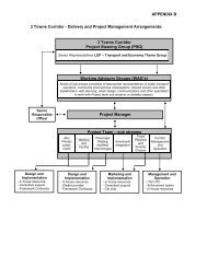
APPENDIX B
(Attachment: 11)Appendix B (57K/bytes) - Borough of Poole
(Attachment: 11)Appendix B (57K/bytes) - Borough of Poole
- No tags were found...

You also want an ePaper? Increase the reach of your titles
YUMPU automatically turns print PDFs into web optimized ePapers that Google loves.
Notes<br />
1. A “Child in Care” means any child who is in the care of a local authority in<br />
accordance with Section 22 (1) of the Children Act 1989. A child who was<br />
“Previously a Child in Care” means a child who, after being Looked After, became<br />
subject to an Adoption Order under Section 46 of the Adoption and Children Act<br />
2002, a Residence Order under Section 8 of the Children Act 1989 or Special<br />
Guardianship Order under Section 14A of the Children Act 1989.<br />
2. The local authority will consider that a child lives at the address at which he/she<br />
lives during the school week. Where a child lives at more than one address during<br />
the school week the local authority will consider the home address as being where<br />
the prime carer resides. The “prime carer” is the person in whose name Child<br />
Benefit payments for the individual child are made. The final decision on the home<br />
address of a child will be made by the local authority. If any information supplied<br />
by an applicant is judged by the local authority to be fraudulent or intentionally<br />
misleading the local authority may refuse to offer a place or, if already offered,<br />
may withdraw the offer.<br />
3. (a) The distance from home to school is measured by using the shortest, safest,<br />
practicable walking route using the centre line of public roads and footpaths<br />
(excluding paths identified for the sole use of bicycles i.e. cycleways) from the<br />
nearest point on the public highway to the centre point of the pupil’s home<br />
address (see Note 2 above) to a point opposite the nearest approved access point<br />
on school property that is for the use of pupils. The GIS maps used are provided<br />
by Ordnance Survey and represent the position as at the beginning of the annual<br />
admission cycle i.e. September in the year prior to admission. Any footpaths or<br />
roads added after this time will not be taken into consideration until the next<br />
academic year of application.<br />
(b) For applicants living on islands within Poole harbour the distance<br />
measurement will be a straight line from the centre point of the home property<br />
(see Note 2) to either:<br />
1. the nearest public landing steps at Poole Quay, or<br />
2. a point on the mainland that the applicant proves to the satisfaction of the<br />
local authority that he/she can access<br />
and from that point the distance will be measured using the shortest, safest,<br />
practicable walking route to the nearest point on the public highway and from<br />
there using the shortest, safest, practicable walking route using the centre line of<br />
public roads and footpaths (excluding paths identified for the sole use of bicycles<br />
i.e. cycleways) to a point opposite the nearest approved access point on school<br />
property that is for the use of pupils.<br />
(c) If an applicant advises the local authority that the child would or could use the<br />
Sandbanks Chain Ferry in the journey to school then the distance will be<br />
measured on that basis from the home address (see Note 2) in line with Note 3(a)<br />
above, including the distance travelled by the ferry.<br />
2