SHORT HISTORY OF THE HYDROGEOLOGICAL INVESTIGATIONS OF THE KARST IN ROMANIA
Untitled
Untitled
- No tags were found...

You also want an ePaper? Increase the reach of your titles
YUMPU automatically turns print PDFs into web optimized ePapers that Google loves.
<strong>SHORT</strong> <strong>HISTORY</strong> <strong>OF</strong> <strong>THE</strong> <strong>HYDROGEOLOGICAL</strong><br />
<strong><strong>IN</strong>VESTIGATIONS</strong> <strong>OF</strong> <strong>THE</strong> <strong>KARST</strong> <strong>IN</strong> <strong>ROMANIA</strong><br />
by Iancu ORêEANU<br />
Romanian Association of Hydrogeologists, ianora@hotmail.com<br />
Investigation of karst areas is a multi-disciplinary<br />
approach, which is the reason why in these<br />
areas the efforts of landforms investigators, cavers,<br />
geologists, hydrologists and hydrogeologists interpenetrate,<br />
one being unable to specify exactly<br />
where some of them start, and where others end.<br />
This is also the case of the research performed in<br />
karst areas of Romania, where the first information<br />
on karst springs and groundwater flow has been<br />
provided by geographers, geologists and cavers.<br />
In the year 1863, the Austrian geographer A.<br />
SCHMIDL has published in Vienna the work<br />
“Das Bihar Gebirge and der Grenze von Ungarn<br />
und Siebenburgen”, the first extensive geographical<br />
study addressing the karstology and the speleology<br />
of an area within the territory of our country.<br />
The author provides a detailed description of the<br />
karst in the mountains Bihor, Vlãdeasa and Codru<br />
Moma, of the main karst springs, of the mineral<br />
and thermal springs in those mountain bodies and<br />
in Beiuº basin.<br />
In the year 1901, the Romanian geologist S.<br />
MIHUÞIA has performed the first tracer testing<br />
of an underground stream course in Romania. By<br />
labeling the water of Þarina stream with charcoal<br />
powder, he outlined the hydrologic connection<br />
between Câmpeneasca cave, in Vaºcãu karst plateau,<br />
and the Boiu spring, next to Vaºcãu town (S.<br />
MIHUÞIA, 1904).<br />
In 1908, Marghitaº and Buhui dams are built<br />
on Buhui stream, the lakes being the only ones in<br />
Romania placed on limestones. Downstream<br />
Buhui lake, controlled water by the dam is then<br />
distributed in the limestones area and feeds, together<br />
with Certej spring, the underground flow<br />
of Buhui cave. At the end of the cave there is an<br />
artificial underground lake, its water supply Anina<br />
town through an artificial gallery, of 1.3 km long<br />
(V. SENCU, 1967).<br />
EM. PROTOPOPESCU-PACHE, in his<br />
studies undertaken in Mangalia area, sets the water<br />
drainage to the springs of sulphurous bath in<br />
the South, as well as the springs placed to the East,<br />
towards the sea, to Constanta highway, by marking<br />
with uranite the waters overflown from Kara-<br />
Oban lake in the nearby ponor (R. COCÂRDEL,<br />
EM. PROTOPOPESCU-PACHE, 1955).<br />
The first systematic hydrologic investigation<br />
of the landforms in the karst areas of Romania has<br />
been performed by the Institute of Speleology<br />
“Emil Racovita” (ISER) and by the Institute of<br />
Geography. Starting from the very first papers<br />
published by the scientists of those two institutes,<br />
M. ªERBAN, D. COMAN and I. VIEHMAN<br />
(Bihor Mountains, 1957), T. RUSU, GH.<br />
RACOVIÞÃ and D. COMAN (Bihor Mountains,<br />
1970), I. VIEHMAN (Bihor Mountains,<br />
1958, 1966), V. SENCU, (Anina area, 1970,<br />
1978, 1986), T. RUSU (Pãdurea Craiului Mountains,<br />
1960-1988), V. TRUFAª (Sebeº Mountains,<br />
1965) and from ISPIF, BIªIR and M.<br />
PASCU (Cerna area, 1967, 1969), there can be<br />
noticed their obvious concern for identifying the<br />
groundwater flow paths, fluorescein tracer tests<br />
being performed in this respect.<br />
Over the time interval 1960-1988, the<br />
Pãdurea Craiului Mountains karst areas have been<br />
subject to detailed karst topography and hydrology<br />
investigations conducted by T. RUSU, who performed<br />
a multitude of fluorescein tracer tests, by<br />
which he outlined the main karst flow directions.<br />
The integral publication of those results occurred<br />
in the year 1988.<br />
The Institute of speleology “Emil Racoviþã”,<br />
specifically its research worker I. POVARÃ, has<br />
carried out over the period 1965-2007 an extensive<br />
activity of investigating the karst hydrogeology<br />
of Cerna stream catchment area, of Mehedinþi<br />
19
Mountains and Plateau, West Jiu area and South<br />
Dobrogea. T. CONSTANT<strong>IN</strong>ESCU performed<br />
tracer tests in Piatra Craiului Massif, G.<br />
DIACONU in Motru Sec area and I. POVARÃ<br />
and V. HOROI in Ardeu watershed. The chemistry<br />
of the karst waters in Pãdurea Craiului, Cerna<br />
trough and Mangalia area made the object of very<br />
detailed studies signed by C. MAR<strong>IN</strong>.<br />
In 1974, M.BLEAHU publishes “Karstic<br />
morphology”, an encyclopaedia about the karst<br />
and its genesis, a work of a highly positive impact<br />
on researching the karst in Romania.<br />
Starting from the year 1970, the Hydrogeological<br />
survey department of Prospectiuni S.A.<br />
company has carried out a constant activity aimed<br />
at investigating the carbonate rocks areas, in order<br />
to complete hydrogeological maps, to compute the<br />
water budget, to assess the groundwater resources,<br />
to delineate the main karst flow paths and to outline<br />
the groundwater chemistry. Those investigation<br />
projects addressed most karst areas in Romania,<br />
being performed by: G. SIMION (Mehedinþi<br />
Mountains, Cerna-Jiul de Vest area), I. LAZU<br />
(Mehedinþi Mountains), M. FERU (Mangalia<br />
area), NICOLLE & I. ORêEANU (Pãdurea<br />
Craiului, Codru Moma, Bihor Vlãdeasa, Trascãu<br />
Mountains, Poieni plateau, Rapolt crystalline<br />
limestones outcrop, Dâmbovicioara Pasasage,<br />
Postãvarul Massif, Reºiþa-Oraviþa area, Teliuc-<br />
Ghelar zone, Mangalia area), E. ANGHEL<br />
(Moneasa and Teliuc-Ghelar areas), A.<br />
IURKIEWICZ (Pãdurea Craiului and Vâlcan<br />
Mountains, Reºiþa-Moldova Nouã area), N.<br />
TERTELEAC (Codru Moma, Dâmbovicioara<br />
Passage), GH. PONTA (Codru Moma,<br />
Cerniºoara-Jiul de Vest area), ELENA & R.<br />
STRUSIEVICI (Cerniºoara-Jiul de Vest area),<br />
RUXANDRA & D. C. SLÃVOACÃ (Vâlcan and<br />
Bucegi Mountains, Mehedinþi Mountains and<br />
Plateau, Cerniºoara-Jiul de Vest area), RÃDIÞA &<br />
G. BANDRABUR (Petreºti-Tureni area, Babadag<br />
Basin, Poiana Ruscã Massif, Mehedinþi Mountains<br />
and Plateau, Sebeº Mountains, Parâng and<br />
Cãpãþânii Mountains, Cerniºoara-Jiul de Vest<br />
area), MIRELA & C. PANAITESCU (Perºani<br />
Mountains), G. DRAGOMIR (Hãghimaº Mountains),<br />
G. DRAGOMIR and C. NAN (Reºiþa-<br />
Anina area), A. ROTARU (Anina-Nera area), A.<br />
ANGHELI (Nera-Dunãre area) and E.<br />
CÃPRARU (SW Vaºcãu Plateau).<br />
In order to delineate the groundwater flow<br />
paths, the company Prospecþiuni S.A. has performed<br />
about 170 tracer tests, many of them in<br />
cooperation with the Tracer group of Institute of<br />
Physics and Nuclear Energy (IF<strong>IN</strong>) led by E.<br />
GAªPAR. For these tracer tests, there have been<br />
initially used radioactive tracers (Iodine-131, Bromide-82),<br />
and after the year 1980, activable tracers<br />
(In-EDTA, Dy-EDTA, La-EDTA), fluorescent<br />
tracers (fluorescein, rhodamine B) and whitening<br />
optic agents (stralex). To some of the tracer tests<br />
performed in Apuseni Mountains, there has also<br />
taken part a group from the High School Institute<br />
in Baia Mare, led by I. POP.<br />
In 1970, D. I. SLÃVOACÃ, I. ORêEANU,<br />
E. GAªPAR and AL. BULGÃR (1985), confirm<br />
the continuity of limestone in the Danubian Unit<br />
under crystalline schists in Motru Sec- Baia de<br />
Aramã by labelling with Iodine-131, demonstrating<br />
thus, based on a hydrogeological method, the presence<br />
of the Gettic Nappe. A marking done 29 years<br />
later, in 1998, by G. & RÃDIÞA BANDRABUR,<br />
D. C. & RUXANDRA SLÃVOACÃ (1998-1999),<br />
in between the lost Prejna river at Balta and Bârza<br />
spring, supports the continuity to South-West of<br />
the same tectonic structure. Another labelling, contributing<br />
to confirming regional geological structures,<br />
was done in Bihor Mountains, the hydrological<br />
connection between the losses at Valea Seacã<br />
stream and the spring of Criºu Bãiþa stream confirming<br />
the continuity of the Bihor Unit limestones<br />
under the permian sandstones of Arieºeni Nappe at<br />
Tapul peak (I. ORêEANU, E. GAªPAR, I. POP.<br />
T. TÃNASE, 1991).<br />
The National Institute of Hydrology and<br />
Water Management (<strong>IN</strong>HWM), specifically its research<br />
workers P. NIÞÃ, AL. BULGÃR, P. MIÞÃ,<br />
DIACONU V., OANCEA V. performed hydrologic<br />
investigations, together with tracer tests. The<br />
group in <strong>IN</strong>HWM, including A. ÞENU, F. D.<br />
DAVIDESCU and ANA SLÃVESCU, has completed<br />
investigations addressing the karst water dynamics<br />
by means of environmental isotopes. Detailed<br />
studies addressed the investigation of the karst<br />
aquifers in South Dobrogea, Valachian Platform<br />
and the origin of the thermal water at Geoagiu and<br />
Felix-1 Mai Spa.<br />
The tracer labellings performed by Institute<br />
of Study and Design for Land Reclamation<br />
(ISPIF), especially by M. Pascu, highlight the un-<br />
20
derground connexion between losses in Jiul de<br />
Vest watershed and Cerna spring and between<br />
losses in flow of Motru Sec river and springs in<br />
Baia de Aramã area. Were also established sanitary<br />
and hydrogeological protection areas of Runcu and<br />
Jaleº springs in Vâlcan Mountains (R. PASCU,<br />
DANA VELICIU, 2000).<br />
The investigation of the karst aquifers in South<br />
Dobrogea focused the interest of a multitude of<br />
scientists, among which we mention: R.<br />
CIOCÂRDEL and EM. PROTOPOPESCU-<br />
PACHE (1955), C. DRAGOMIRESCU (1971), I.<br />
NA<strong>IN</strong>ER (1971-1973), N. PITU (1980),<br />
V. MOLDOVEANU (1987-1988), F.<br />
ZAMFIRESCU, A. DANCHIV, M. ALBU, M.<br />
ENÃCHESCU and V. MOLDOVEANU (1993),<br />
F. ZAMFIRESCU, V. MOLDOVEANU, C.<br />
D<strong>IN</strong>U, N. PITU, M. ALBU, A. DANCHIV and<br />
H. NASH (1994).<br />
Contributions to the investigation of<br />
Mangalia area are due to GH. VASILESCU and<br />
SILVIA MATEI (1967), A. ÞENU and G.<br />
NEACªU (1968), I. NIÞÃ (1971), M. FLORIAN<br />
and GABRIELA POPESCU-DUMITRESCU<br />
(1972), I. IANCULESCU (1980), E. GAªPAR<br />
and I. ORêEANU (1987), I. ORêEANU<br />
(1993, 1994), V. MOLDOVEANU, C. D<strong>IN</strong>U,<br />
P. GEORGESCU and V. NICULESCU (1988-<br />
1990), M. FERU and ANA CAPOTÃ (1991), M.<br />
FERU (1993), I. POVARÃ (1994), C. MAR<strong>IN</strong><br />
and TUDORA NICOLESCU (1993), T.<br />
PARKER (1994).<br />
Consistent data regarding geological structure<br />
and hydrogeology of karst reservoirs has brought<br />
by drilling wells performed by Foradex SA (former<br />
ISEM company), Enterprise for Driling and Special<br />
Geological Works (ISLGC) and Institute of<br />
Balneology and Physiotherapy (IBF)<br />
Starting with 1970, the Institute of Atomic<br />
Physics, later named Institute of Physics and Nuclear<br />
Energy, has brought major contributions, by<br />
the team led by E. GAªPAR, to developing and applying<br />
marking technologies with radioactive and<br />
activable tracers in the study of karstic aquifers. In<br />
a permanent cooperation with researchers from institutes<br />
involved in the study of karstic areas, the<br />
team of tracers took part in a large number of markings,<br />
highly contributing to knowing the dynamics<br />
of underground waters in all areas of carbonate<br />
waters in Romania. In this team there were and<br />
there are following researchers: R. CATIL<strong>IN</strong>A, S.<br />
CRÃCIUN, LUCREÞIA D<strong>IN</strong>ESCU, R.<br />
GAªPAR, M. MIDOIU, MARIA PASCU, B.<br />
PÃUNICÃ, G. POPOVICI, C. STANCA, P.<br />
STÃNESCU, T. TÃNASE, L. TIM<strong>OF</strong>TE.<br />
E. GAªPAR is the author of “Modern trends<br />
in tracer hydrology” (1987) and “Tracers in aquifer<br />
systems” (1994), reference books in using tracers in<br />
hydrology. He has also published, on his own or<br />
with other co-authors, several articles on results of<br />
tracer tests and was constantly interested in finding<br />
new labelling technologies and new tracers to explore<br />
the dynamics of underground waters.<br />
Hydrogeological research of karstic areas to<br />
point out still waters is the topic of articles published<br />
by M. PASCU, C. MOISSIU and AL<strong>IN</strong>A<br />
MOISESCU in 1984 (Scropoasa supplies, Izvorul<br />
Minunilor at Stâna de Vale, Bârza-Topleþ and<br />
Murighiol), EUGENIA PÂRVÃNESCU and A.<br />
PÂRVÃNESCU in 1991 (“ªapte Izvoare Reci”,<br />
Scropoasa area), ILEANA TIÞA and V. MICULA<br />
in 1998 („Hera spring” in Vlãdeasa Massif) and I.<br />
ORêEANU the same year (Bihor Vlãdeasa and<br />
Codru Moma mountains).<br />
Starting with 1983, the review “Theoretical and<br />
Applied Karstology” is being published, with works<br />
presented at seminars on this topic, organised by Emil<br />
Racoviþã Institute of Speology and S.C. Prospecþiuni<br />
S.A. In 1987, E. GAªPAR and I. ORêEANU publish<br />
in this series an article about natural and artificial<br />
tracers used in the study of karst hydrodynamics, A.<br />
IURKIEWICZ and A. MANG<strong>IN</strong> publish in 1994<br />
a synthesis of using the systemic analysis in the study<br />
of karstic aquifers in Vâlcan mountains, while in<br />
1995, A. ÞENU and F. DAVIDESCU publish another<br />
synthesis on using the environmental isotopes<br />
in the study of carbonate karstic aquifers in Romania.<br />
In 1991 and 1996, I. ORêEANU publishes in the<br />
same review hydrogeological maps at 1:50,000 scale,<br />
of Pãdurea Craiului and Bihor Vlãdeasa Mountains.<br />
In 1985, the Geological Institute of Romania<br />
publishes the Vaºcãu sheet of the hydrological map<br />
of Romania, at 1:50,000 scale, drafting by GH.<br />
PONTA, M. BLEAHU, S. PAN<strong>IN</strong> and I.<br />
ORêEANU.<br />
In 2002, A. ISTRATE, in the “Hydrokarstic<br />
systems of Bucegi Mountains” publishes the results<br />
of his research in the high watershed of Ialomiþa river.<br />
The knowledge of karstic hydrographs of Apuseni<br />
Mountains was supported by a major contribution of<br />
21
works undertaken by L. VÃLENAª, B. ONAC, P.<br />
COCEAN, E. SILVESTRU and P. E. DAMM.<br />
We also need to mention the key contribution<br />
in exploring and researching the karst in Romania<br />
of amateur speleologists. In many cases, the<br />
caves and avens they have found supported the<br />
researchers in exploring this invaluable asset.<br />
Hydrogeological knowledge of karst areas<br />
were the object of PhD Thesis performed by T.<br />
RUSU (1979), A. ÞENU (1979), N. PITU (1981),<br />
I. POVARÃ (1997), V. MOLDOVEANU (1999),<br />
I. ORêEANU (2000), G. ISTRATE (2001), A.<br />
IURKIEWICZ (2004), and A. ROTARU (2009).<br />
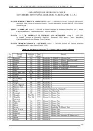
The largest karst springs in the Carpathian<br />
Orogene have 1-2 m 3 /s average flow rates (table 1),<br />
their occurrence being related to the presence of<br />
unary karst type systems, with homogeneous limestone<br />
bodies extending over large surfaces (the<br />
springs in downstream gorges of Dâmboviþa stream,<br />
Ochiu Beiului spring in Banat Mountains, Boiu<br />
spring in Vaºcãu Plateau), or to of a widely developed<br />
non-karst catchment area within the binary karst systems<br />
(Cerna spring, Bârza spring, springs in Vâlcan<br />
Mountains). In Apuseni Mountains, although carbonate<br />
rocks extend over large areas, the tectonic<br />
structural pattern to which they had been subjected<br />
has resulted in a kaleidoscope-like structure, where<br />
carbonate deposits are scattered within the bulk of<br />
other deposits. This structural framework did not<br />
favor the development of large extent karst systems,<br />
so that flow rates of the most important springs do<br />
not exceed 500-600 l/s as mean annual discharge.<br />
The largest distance between sinking points<br />
and outlets, recorded as a result of the tracer tests<br />
performed in Romania so far, is 23.6 km (table 2).<br />
It was reached along the connection between losses<br />
of Cerna river in Bobotului gorges and Neptun<br />
springs in Bãile Herculane spa (G. SIMION, E.<br />
GASPAR, 1976). The flow path between the sinking<br />
point of Prejna stream in Mehedinþi Plateau<br />
and Bârza spring in Mehedinþi Mountains is 22.0<br />
km long (G. BANDRABUR et al,1998-1999),<br />
thus being the second longest.<br />
The higher difference in level recorded as a<br />
result of the performed tracer tests is 775 m between<br />
Balta Cerbului ponor and Seven Cold Springs in<br />
Mehedinþi Mountains (I. POVARÃ, 1980), followed<br />
by 700 m elevation drop between Scorota<br />
ponor in Retezat Mountains and Cerna spring in<br />
Godeanu Mountains (G. PONTA et al., 1984).<br />
22<br />
References<br />
Bandrabur Gh., Slãvoacã D., Bandrabur Rãdiþa,<br />
Slãvoacã Ruxandra (1998-1999): Considérations<br />
hydrodynamiques sur le système karstique<br />
de Bârza (Monts et Plateau de Mehedinþi, Romania).<br />
Theor. Appl. Karst., 11-12, pp. 133-<br />
138, Bucharest.<br />
Bleahu M., Decu V., Negrea St., Pleºa C., Povarã<br />
I., Viehmann I. (1976): Peºteri din Romania.<br />
Ed. ºtiinþificã ºi enciclopedicã, Bucureºti, 415p.<br />
Bretoteanu M., Þenu A. (2000): Scurtã privire<br />
asupra activitãþii de hidrogeologie desfãºuratã în<br />
cadrul Institutului Naþional de Meteorologie ºi<br />
Hidrologie. Lucrãrile Simpozionului “100 de<br />
ani de hidrogeologie modernã în România”,<br />
24-26 mai 2000, Bucureºti, p. 117-129.<br />
Bulgãr A., Diaconu V., Oancea V. (1984): Modern<br />
methods in karst hydrological research. Application<br />
to some principal karst systems from<br />
the Southern Carpathians. Theoretical and Applied<br />
Karstology, 1, 215-224, Bucharest.<br />
Cineti A. F. (1990): Resursele de ape subterane ale<br />
României. Ed. Tehnicã., 296 p., Bucureºti.<br />
Ciocârdel R., Protopopescu Pache Em. (1955):<br />
Consideraþii hidrogeologice asupra Dobrogei.<br />
St. Tehn. Ec., seria B, nr. 3, Bucureºti.<br />
Davidescu F. D., Þenu A., Slãvescu Ana (1991):<br />
Environmental isotopes in karst hydrology. A<br />
lay-out of problems with exemplifications in<br />
Romania: Theoretical and Applied Karstology,<br />
v. 4, p. 77-86, Bucharest.<br />
Gaºpar E. (1994): Trasori în sisteme acvifere.<br />
Ed.Academiei Române, Bucureºti. 234 pages.<br />
Gaºpar E., Orãºeanu I. (1987): Natural and artificial<br />
tracers in the study of the hydrodynamics<br />
of the karst. Theoretical and Applied Karstology<br />
3, 31-107, Bucharest.<br />
Istrate A. (2001): Hidrogeologia carstului din zona<br />
Cheile Tãtarului - Scropoasa, Masivul Bucegi,<br />
cu privire la evaluarea resurselor exploatabile de<br />
ape subterane, pe baza datelor de regim ale<br />
debitelor izvoarelor. PhD Thesis, University of<br />
Bucharest.<br />
Istrate A. (2002): Sisteme hidrocarstice din Masivul<br />
Bucegi. Ed. Cetatea de Scaun, Târgoviºte,<br />
222 P.<br />
Iurkiewicz A. (2004): Analiza sistemicã în investigarea<br />
hidrodinamicã a acviferelor carstice (exemple<br />
semnificative din Romania). PhD Thesis,<br />
University of Bucharest, 280 p.
n v<br />
, (Qmax /Qmin); B f<br />
, base flow index (the ratio between Qmean of the drought month and Q mean annual).<br />
* ) cumulated flow;<br />
** ) expeditionary measurements;<br />
*** ) data processing in Podu Dâmboviþei and Rucãr hydrometric sections.<br />
Table 1. Largest springs in Romanian Carpathian Orogene karst areas (mean annual discharge more than 300 l/s)<br />
23
24<br />
H-elevation, in meters a.s.l., L-horizontal distance between losses and Spring s, DH-Difference in level between insurgence and resurgence; T-time of first<br />
arrival of tracer; V-apparent velocity. Tracers: T= Tritium; F=Fluoresceine, R=Rhodamine B, I=I-131,In= In-EDTA, Dy=Dysprosium EDTA.<br />
*) Unpublished report. Authors of labellings: (1) G. Ponta, E. Gaºpar, R. Strusiewicz; (2) D. I. Slãvoacã, E. Gaºpar, I. Orãºeanu, A. Bulgãr; (3) I.<br />
Orãºeanu,<br />
E. Gaºpar, T. Tãnase, Gh. Ponta, N. Terteleac, G. Halasi; (4) I. Orãºeanu, E. Gaºpar, I. Pop, T. Tãnase<br />
Table 2. Largest lengths (A) and difference in level (B) recorded in tracing operations performed in Romanian Carpathian Orogene karst areas
Iurkiewicz A., Mangin A. (1994): Utilisation de<br />
l’analyse systémique dans l'étude des aquiferes<br />
karstiques des Monts Vâlcan, Theoretical and<br />
Applied Karstology, 7, Ed. Academiei Române,<br />
Bucureºti, pp 9-96.<br />
Iurkiewicz A., Orãºeanu I. (1995): Karstic terraines<br />
and major karsic systems in Romania. Karst<br />
Water Resources (Proceedings of the Ankara-<br />
Antalya Symposium, July, 1995) A.A.Balkema/<br />
Rotterdam/ Brookfield/ 1997, 471-478.<br />
Maieru Cornelia, Orãºeanu I., Palcu M. (2000):<br />
50 de ani de hidrogeologie la S.C. Prospecþiuni<br />
S.A. Lucrãrile Simpozionului “100 de ani de<br />
hidrogeologie modernã în România”, 24-26<br />
mai 2000, Bucureºti, p. 107-116.<br />
Moldoveanu V. (1999): Studiul condiþiilor hidrogeologice<br />
ale Dobrogii de Sud pentru reevaluarea<br />
resurselor exploatabile. PhD Thesis, University<br />
of Bucharest, 164 p.<br />
Orãºeanu I. (1991): Hydrogeological map of the<br />
Pãdurea Craiului Mountains, (Romania). Theoretical<br />
and Applied Karstology 4, 97-127,<br />
Bucharest.<br />
Orãºeanu I. (1996): Contributions to the hydrogeology<br />
of the karst areas of the Bihor-Vlãdeasa<br />
Mountains. Theoretical and Applied Karstology<br />
9, 185-214, Bucharest.<br />
Orãºeanu I. (2000 a): Contribuþii la cunoaºterea<br />
hidrodinamicii sistemelor acvifere carstice din<br />
Munþii Apuseni. PhD. Thesis, University of<br />
Bucharest, 256 p.<br />
Orãºeanu I. (2000 b): Consideraþii privind cercetarea<br />
hidrogeologicã a arealelor carstice din<br />
România. Lucrãrile Simpozionului “100 de ani<br />
de hidrogeologie modernã în România”, 24-26<br />
mai 2000, Bucureºti, p. 117-129.<br />
Orãºeanu I., Bulgãr A., Gaºpar E., Terteleac N.<br />
(1984): Hydrogeological study of Dâmbovicioara<br />
Passage. Theoretical and Applied Karstology<br />
1, 153-164, Bucharest.<br />
Orãºeanu I., Gaºpar E., Pop I., Tãnase T. (1991):<br />
Tracers experiments in the karst area of Bihor<br />
Mountains (Romania). Theoretical and Applied<br />
Karstology 4, 159-172, Bucharest.<br />
Orghidan T., Negrea St., Racoviþã Gh., Lascu C.<br />
(1984): Peºteri din Romania. Ghid turistic. Ed.<br />
sport-turism, 454 p, Bucureºti.<br />
Pascu M. R., Veliciu Dana. (2000): 50 de ani de<br />
Hidrogeologie la I.S.P.I.F. Lucrãrile Simpozionului<br />
“100 de ani de hidrogeologie modernã<br />
în România”, 24-26 mai 2000, Bucuresti, p.<br />
134-139.<br />
Pitu N. (1981): Contribuþii la studiul miºcãrii<br />
apelor subterane în roci fisurate, cu particularizare<br />
la complexul acvifer din zona litoralului.<br />
PhD Thesis, University of Bucharest, 163 p.<br />
Ponta G., Strusiewicz R., Simion G., Gaºpar E.<br />
(1984): Subterranean stream piracy in the Jiul<br />
de Vest - Cerniºoara karst area, Romania. Theoretical<br />
and Applied Karstology, v. 1, p. 235-<br />
238, Bucureºti.<br />
Povarã I. (1980): Note sur la circulation souterraine<br />
des eaux dans les calcaires du bassin de<br />
Cerna. Trav. Inst. Speol. „E. Racovitza”, t. XIX,<br />
p. 237-241, 1 tab., Bucureºti.<br />
Povarã I. (1997): Studiu fizico geografic al bazinului<br />
hidrografic Cerna, cu privire specialã asupra<br />
hidrologiei carstice (1997). PhD Thesis,<br />
Bucharest University, 216 p.<br />
Povarã I., Rãdulescu D., Stãnescu I., Gaºpar E.,<br />
Bulgãr Al. (1987): Aquiferous interconnexions<br />
in the Motru-Izvarna-Tismana-Bistriþa karst<br />
area, Theoretical and Applied Karstology, 3,<br />
Bucharest, p.199-214.<br />
Rotaru A. (2009): Contribuþii la simularea<br />
regimului de curgere al izvoarelor carstice cu<br />
aplicaþii la sistemul carstic Motru Sec-Baia de<br />
Aramã. PhD Thesis, University of Bucharest,<br />
154 p.<br />
Rusu T. (1979): Carstul din Munþii Pãdurea<br />
Craiului. PhD. Thesis, 199 p., Univ. din Cluj-<br />
Napoca.<br />
Rusu T. (1988): Carstul din Munþii Pãdurea<br />
Craiului. Pe urmele apelor subterane. Editura<br />
Dacia, Cluj-Napoca, 254 p.<br />
Sencu V., 1986, Field measurements relating to<br />
the subterranean runoff of karst waters in the<br />
Anina Mountains, Z. Geomorph. N.F., p.59-<br />
68, Berlin, Stuttgart.<br />
Slãvoacã I. D., Orãºeanu I., Gaºpar E., Bulgãr A.<br />
(1985): Hydrogeological contributions for the<br />
existence of the Getic Nappe in the Motru Sec-<br />
Baia de Aramã region.Theor. Apply. Karst., 2,<br />
pp.175-181, Bucharest.<br />
Þenu A. (1979): Studiul geochimic ºi izotopic al<br />
zãcãmintelor de ape hiprtermale din partea de<br />
nord-est a Depresiunii Pannonice. PhD Thesis,<br />
255 p.<br />
25
Þenu A., Davidescu F. (2000): Treizeci de ani de<br />
hidrogeologie izotopicã în România. Lucrãrile<br />
Simpozionului “100 de ani de hidrogeologie<br />
modernã în România”, 24-26 mai 2000,<br />
Bucureºti, p. 82-96.<br />
Zamfirescu F. (2000): Un secol de hidrogeologie<br />
în România. Lucrãrile Simpozionului “100 de<br />
ani de hidrogeologie modernã în România”,<br />
24-26 mai 2000, Bucureºti, p. 1-8.<br />
26