Dominic Winter
1Le95JD
1Le95JD

Create successful ePaper yourself
Turn your PDF publications into a flip-book with our unique Google optimized e-Paper software.
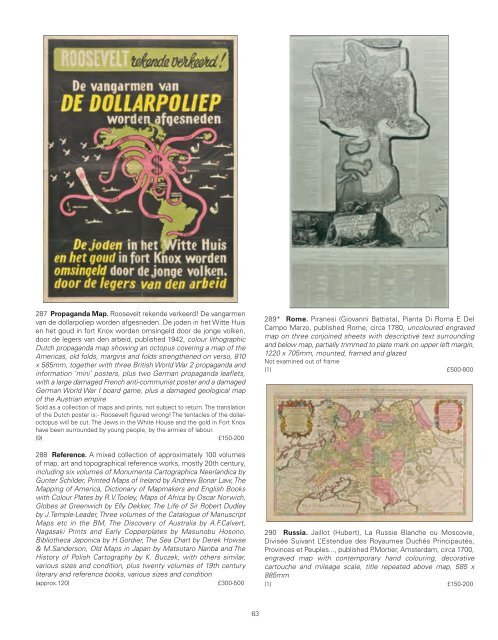
287 Propaganda Map. Roosevelt rekende verkeerd! De vangarmen<br />
van de dollarpoliep worden afgesneden. De joden in het Witte Huis<br />
en het goud in fort Knox worden omsingeld door de jonge volken,<br />
door de legers van den arbeid, published 1942, colour lithographic<br />
Dutch propaganda map showing an octopus covering a map of the<br />
Americas, old folds, margins and folds strengthened on verso, 810<br />
x 585mm, together with three British World War 2 propaganda and<br />
information ‘mini’ posters, plus two German propaganda leaflets,<br />
with a large damaged French anti-communist poster and a damaged<br />
German World War I board game, plus a damaged geological map<br />
of the Austrian empire<br />
Sold as a collection of maps and prints, not subject to return. The translation<br />
of the Dutch poster is:- Roosevelt figured wrong! The tentacles of the dollaroctopus<br />
will be cut. The Jews in the White House and the gold in Fort Knox<br />
have been surrounded by young people, by the armies of labour.<br />
(9) £150-200<br />
288 Reference. A mixed collection of approximately 100 volumes<br />
of map, art and topographical reference works, mostly 20th century,<br />
including six volumes of Monumenta Cartographica Neerlandica by<br />
Gunter Schilder, Printed Maps of Ireland by Andrew Bonar Law, The<br />
Mapping of America, Dictionary of Mapmakers and English Books<br />
with Colour Plates by R.V.Tooley, Maps of Africa by Oscar Norwich,<br />
Globes at Greenwich by Elly Dekker, The Life of Sir Robert Dudley<br />
by J.Temple-Leader, Three volumes of the Catalogue of Manuscript<br />
Maps etc in the BM, The Discovery of Australia by A.F.Calvert,<br />
Nagasaki Prints and Early Copperplates by Masunobu Hosono,<br />
Bibliotheca Japonica by H.Gordier, The Sea Chart by Derek Howse<br />
& M.Sanderson, Old Maps in Japan by Matsutaro Nanba and The<br />
History of Polish Cartography by K. Buczek, with others similar,<br />
various sizes and condition, plus twenty volumes of 19th century<br />
literary and reference books, various sizes and condition<br />
(approx.120) £300-500<br />
289* Rome. Piranesi (Giovanni Battista), Pianta Di Roma E Del<br />
Campo Marzo, published Rome, circa 1780, uncoloured engraved<br />
map on three conjoined sheets with descriptive text surrounding<br />
and below map, partially trimmed to plate mark on upper left margin,<br />
1220 x 705mm, mounted, framed and glazed<br />
Not examined out of frame<br />
(1) £500-800<br />
290 Russia. Jaillot (Hubert), La Russie Blanche ou Moscovie,<br />
Divisée Suivant L’Estendue des Royaumes Duchés Principautés,<br />
Provinces et Peuples..., published P.Mortier, Amsterdam, circa 1700,<br />
engraved map with contemporary hand colouring, decorative<br />
cartouche and mileage scale, title repeated above map, 585 x<br />
885mm<br />
(1) £150-200<br />
63