
Create successful ePaper yourself
Turn your PDF publications into a flip-book with our unique Google optimized e-Paper software.
LONGFORD ESTATES<br />
AND ST. NICHOLAS HOSPITAL<br />
Land off <strong>Britford</strong> <strong>Lane</strong>, Harnham, Salisbury<br />
Key Consideration: Traffic Drainage and flooding<br />
KEY CONSIDERATIONS<br />
The proposed site is at low risk of flooding from the River Avon. The site is situated 80 metres from the River and does not sit on watermeadows.<br />
It also lies outside of the Environment Agency’s designated Flood Zone.<br />
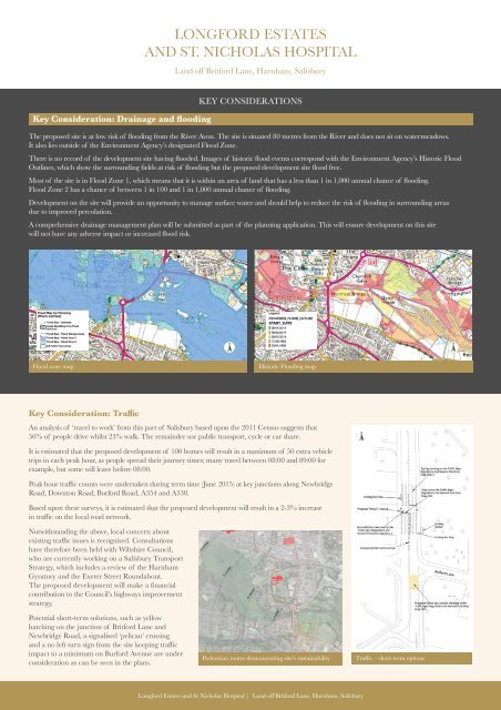
There is no record of the development site having flooded. Images of historic flood events correspond with the Environment Agency’s Historic Flood<br />
Outlines, which show the surrounding fields at risk of flooding but the proposed development site flood free.<br />
Most of the site is in Flood Zone 1, which means that it is within an area of land that has a less than 1 in 1,000 annual chance of flooding.<br />
Flood Zone 2 has a chance of between 1 in 100 and 1 in 1,000 annual chance of flooding.<br />
Development on the site will provide an opportunity to manage surface water and should help to reduce the risk of flooding in surrounding areas<br />
due to improved percolation.<br />
A comprehensive drainage management plan will be submitted as part of the planning application. This will ensure development on this site<br />
will not have any adverse impact or increased flood risk.<br />
Flood zone map<br />
Historic Flooding map<br />
Key Consideration: Traffic<br />
An analysis of ‘travel to work’ from this part of Salisbury based upon the 2011 Census suggests that<br />
56% of people drive whilst 23% walk. The remainder use public transport, cycle or car share.<br />
It is estimated that the proposed development of 100 homes will result in a maximum of 50 extra vehicle<br />
trips in each peak hour, as people spread their journey times; many travel between 08:00 and 09:00 for<br />
example, but some will leave before 08:00.<br />
Peak hour traffic counts were undertaken during term time (June 2015) at key junctions along Newbridge<br />
Road, Downton Road, Burford Road, A354 and A338.<br />
Based upon these surveys, it is estimated that the proposed development will result in a 2-3% increase<br />
in traffic on the local road network.<br />
Notwithstanding the above, local concern about<br />
existing traffic issues is recognised. Consultations<br />
have therefore been held with Wiltshire Council,<br />
who are currently working on a Salisbury Transport<br />
Strategy, which includes a review of the Harnham<br />
Gyratory and the Exeter Street Roundabout.<br />
The proposed development will make a financial<br />
contribution to the Council’s highways improvement<br />
strategy.<br />
Potential short-term solutions, such as yellow<br />
hatching on the junction of <strong>Britford</strong> <strong>Lane</strong> and<br />
Newbridge Road, a signalised ‘pelican’ crossing<br />
and a no left turn sign from the site keeping traffic<br />
impact to a minimum on Burford Avenue are under<br />
consideration as can be seen in the plans.<br />
Pedestrian routes demonstrating site’s sustainability<br />
Traffic – short term options<br />
Longford Estates and St Nicholas Hospital | Land off <strong>Britford</strong> <strong>Lane</strong>, Harnham, Salisbury