

Assessment of the vegetation cover of northern high mountains in Jordan - JBES
The vegetation cover of the northern mountains of Jordan was investigated and surveyed. Line transects sampling method as well as walking through methods have been applied in this study. A total area of 15x80 km was studied and divided into grid system, and thus the selected grids have been used for the line transect sampling. The study showed that the natural forest of Aleppo pine, evergreen oak forest, deciduous oak forest, degraded forest and manmade Aleppo pine forest areas are suffering from man interference and continuous encroachment for the uses of agriculture, urbanization, grazing, fire and querying. The available plant species under forest were collected and herbarium specimens are prepared and deposited. Analysis parameters such as density (D), relative density (RD), frequency (F), relative frequency (RF), abundance (A), relative abundance (RA) and the importance value (IV) are studied. The values of the parameters are recorded for all species, but since the number of collected species is more than 500, then these parameters are listed for the highest 20 species to show clear image about the most dominant and the most abundant and other parameters. From the quantitative ecological analysis using various parameters, the species recoded as having the highest values such as Quercus coccifera, Sarcopoterium spinosum, Asphodelus aestivus, Eryngium creticum, Ononis natrix and others confirm that the study area falls within a Mediterranean biogeographic zone in Jordan. Based on the obtained results, it is highly recommended thus to exert maximum efforts to conserve such limited forest cover, since Jordan, is classified as a country with dry to semidry ecosystem. In addition some of the rare and endemic recorded species occur only under forest cover, particularly the orchid species. This articles originally published at: http://www.innspub.net/volume-6-number-5-may-2015-jbes/
The vegetation cover of the northern mountains of Jordan was investigated and surveyed. Line transects sampling method as well as walking through methods have been applied in this study. A total area of 15x80 km was studied and divided into grid system, and thus the selected grids have been used for the line transect sampling. The study showed that the natural forest of Aleppo pine, evergreen oak forest, deciduous oak forest, degraded forest and manmade Aleppo pine forest areas are suffering from man interference and continuous encroachment for the uses of agriculture, urbanization, grazing, fire and querying. The available plant species under forest were collected and herbarium specimens are prepared and deposited. Analysis parameters such as density (D), relative density (RD), frequency (F), relative frequency (RF), abundance (A), relative abundance (RA) and the importance value (IV) are studied. The values of the parameters are recorded for all species, but since the number of collected species is more than 500, then these parameters are listed for the highest 20 species to show clear image about the most dominant and the most abundant and other parameters. From the quantitative ecological analysis using various parameters, the species recoded as having the highest values such as Quercus coccifera, Sarcopoterium spinosum, Asphodelus aestivus, Eryngium creticum, Ononis natrix and others confirm that the study area falls within a Mediterranean biogeographic zone in Jordan. Based on the obtained results, it is highly recommended thus to exert maximum efforts to conserve such limited forest cover, since Jordan, is classified as a country with dry to semidry ecosystem. In addition some of the rare and endemic recorded species occur only under forest cover, particularly the orchid species. This articles originally published at: http://www.innspub.net/volume-6-number-5-may-2015-jbes/

You also want an ePaper? Increase the reach of your titles
YUMPU automatically turns print PDFs into web optimized ePapers that Google loves.
J. Bio. & Env. Sci. 2015<br />
on this critical region, especially ethnobotany and<br />
survey <strong>of</strong> medic<strong>in</strong>al plants and flora analysis.<br />
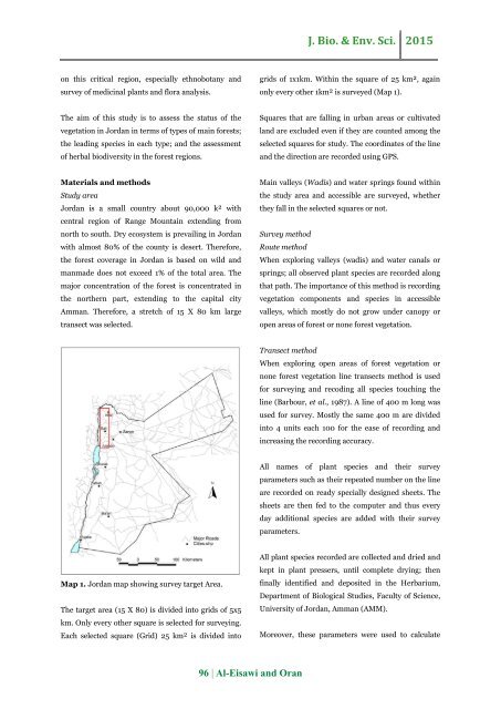
grids <strong>of</strong> 1x1km. With<strong>in</strong> <strong>the</strong> square <strong>of</strong> 25 km², aga<strong>in</strong><br />
only every o<strong>the</strong>r 1km² is surveyed (Map 1).<br />
The aim <strong>of</strong> this study is to assess <strong>the</strong> status <strong>of</strong> <strong>the</strong><br />
<strong>vegetation</strong> <strong>in</strong> <strong>Jordan</strong> <strong>in</strong> terms <strong>of</strong> types <strong>of</strong> ma<strong>in</strong> forests;<br />
<strong>the</strong> lead<strong>in</strong>g species <strong>in</strong> each type; and <strong>the</strong> assessment<br />
<strong>of</strong> herbal biodiversity <strong>in</strong> <strong>the</strong> forest regions.<br />
Squares that are fall<strong>in</strong>g <strong>in</strong> urban areas or cultivated<br />
land are excluded even if <strong>the</strong>y are counted among <strong>the</strong><br />
selected squares for study. The coord<strong>in</strong>ates <strong>of</strong> <strong>the</strong> l<strong>in</strong>e<br />
and <strong>the</strong> direction are recorded us<strong>in</strong>g GPS.<br />
Materials and methods<br />
Study area<br />
<strong>Jordan</strong> is a small country about 90,000 k² with<br />
central region <strong>of</strong> Range Mounta<strong>in</strong> extend<strong>in</strong>g from<br />
north to south. Dry ecosystem is prevail<strong>in</strong>g <strong>in</strong> <strong>Jordan</strong><br />
with almost 80% <strong>of</strong> <strong>the</strong> county is desert. Therefore,<br />
<strong>the</strong> forest <strong>cover</strong>age <strong>in</strong> <strong>Jordan</strong> is based on wild and<br />
manmade does not exceed 1% <strong>of</strong> <strong>the</strong> total area. The<br />
major concentration <strong>of</strong> <strong>the</strong> forest is concentrated <strong>in</strong><br />
<strong>the</strong> nor<strong>the</strong>rn part, extend<strong>in</strong>g to <strong>the</strong> capital city<br />
Amman. Therefore, a stretch <strong>of</strong> 15 X 80 km large<br />
transect was selected.<br />
Ma<strong>in</strong> valleys (Wadis) and water spr<strong>in</strong>gs found with<strong>in</strong><br />
<strong>the</strong> study area and accessible are surveyed, whe<strong>the</strong>r<br />
<strong>the</strong>y fall <strong>in</strong> <strong>the</strong> selected squares or not.<br />
Survey method<br />
Route method<br />
When explor<strong>in</strong>g valleys (wadis) and water canals or<br />
spr<strong>in</strong>gs; all observed plant species are recorded along<br />
that path. The importance <strong>of</strong> this method is record<strong>in</strong>g<br />
<strong>vegetation</strong> components and species <strong>in</strong> accessible<br />
valleys, which mostly do not grow under canopy or<br />
open areas <strong>of</strong> forest or none forest <strong>vegetation</strong>.<br />
Transect method<br />
When explor<strong>in</strong>g open areas <strong>of</strong> forest <strong>vegetation</strong> or<br />
none forest <strong>vegetation</strong> l<strong>in</strong>e transects method is used<br />
for survey<strong>in</strong>g and recod<strong>in</strong>g all species touch<strong>in</strong>g <strong>the</strong><br />
l<strong>in</strong>e (Barbour, et al., 1987). A l<strong>in</strong>e <strong>of</strong> 400 m long was<br />
used for survey. Mostly <strong>the</strong> same 400 m are divided<br />
<strong>in</strong>to 4 units each 100 for <strong>the</strong> ease <strong>of</strong> record<strong>in</strong>g and<br />
<strong>in</strong>creas<strong>in</strong>g <strong>the</strong> record<strong>in</strong>g accuracy.<br />
All names <strong>of</strong> plant species and <strong>the</strong>ir survey<br />
parameters such as <strong>the</strong>ir repeated number on <strong>the</strong> l<strong>in</strong>e<br />
are recorded on ready specially designed sheets. The<br />
sheets are <strong>the</strong>n fed to <strong>the</strong> computer and thus every<br />
day additional species are added with <strong>the</strong>ir survey<br />
parameters.<br />
Map 1. <strong>Jordan</strong> map show<strong>in</strong>g survey target Area.<br />
The target area (15 X 80) is divided <strong>in</strong>to grids <strong>of</strong> 5x5<br />
km. Only every o<strong>the</strong>r square is selected for survey<strong>in</strong>g.<br />
Each selected square (Grid) 25 km² is divided <strong>in</strong>to<br />
All plant species recorded are collected and dried and<br />
kept <strong>in</strong> plant pressers, until complete dry<strong>in</strong>g; <strong>the</strong>n<br />
f<strong>in</strong>ally identified and deposited <strong>in</strong> <strong>the</strong> Herbarium,<br />
Department <strong>of</strong> Biological Studies, Faculty <strong>of</strong> Science,<br />
University <strong>of</strong> <strong>Jordan</strong>, Amman (AMM).<br />
Moreover, <strong>the</strong>se parameters were used to calculate<br />
96 | Al-Eisawi and Oran


