


You also want an ePaper? Increase the reach of your titles
YUMPU automatically turns print PDFs into web optimized ePapers that Google loves.
EASO Country of Origin Information Report — Eritrea. Country Focus — 19<br />
Administrations at all levels are referred to as mmhidar in Tigrinya. The kebabi administrations hold most significance<br />
to the population on a day-to-day basis since they keep written population registers and function as the first point<br />
of contact with the authorities (62). The nus-zoba administrations keep electronic population registers (63).<br />
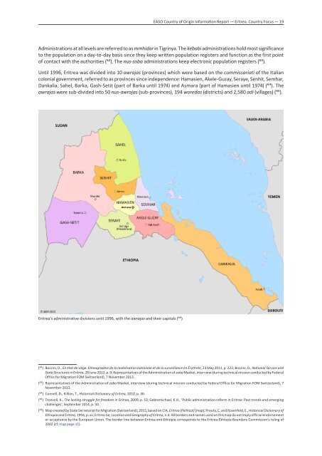
Until 1996, Eritrea was divided into 10 awrajas (provinces) which were based on the commissariati of the Italian<br />
colonial government, referred to as provinces since independence: Hamasien, Akele-Guzay, Seraye, Senhit, Semhar,<br />
Dankalia, Sahel, Barka, Gash-Setit (part of Barka until 1974) and Asmara (part of Hamasien until 1974) (64). The<br />
awrajas were sub-divided into 50 nus-awrajas (sub-provinces), 194 woredas (districts) and 2,580 adi (villages) (65).<br />
Eritrea’s administrative divisions until 1996, with the awrajas and their capitals (66)<br />
(62) Bozzini, D., En état de siège. Ethnographie de la mobilisation nationale et de la surveillance en Érythrée, 23 May 2011, p. 222; Bozzini, D., National Service and<br />
State Structures in Eritrea, 28 June 2012, p. 9; Representatives of the Administration of zoba Maekel, interview (during technical mission conducted by Federal<br />
Office for Migration FOM Switzerland), 7 Novem<strong>ber</strong> 2013.<br />
(63) Representatives of the Administration of zoba Maekel, interview (during technical mission conducted by Federal Office for Migration FOM Switzerland), 7<br />
Novem<strong>ber</strong> 2013.<br />
(64) Connell, D., Killion, T., Historical Dictionary of Eritrea, 2010, p. 36.<br />
(65) Tronvoll, K., The lasting struggle for freedom in Eritrea, 2009, p. 53; Gebremichael, K.H., ‘Public administration reform in Eritrea: Past trends and emerging<br />
challenges’, Septem<strong>ber</strong> 2014, p. 50.<br />
(66) Map created by State Secretariat for Migration (Switzerland), 2015, based on CIA, Eritrea (Political) [map]; Prouty, C. and Rosenfeld, E., Historical Dictionary of<br />
Ethiopia and Eritrea, 1994, p. xx; Eritrea.be, Location and Geography of Eritrea, n.d. All borders and names used on this map do not imply official endorsement<br />
or acceptance by the European Union. The border line between Eritrea and Ethiopia corresponds to the Eritrea-Ethiopia Boundary Commission’s ruling of<br />
2002 (cf. map page 11).