Laboratory / Flex Space Available One Parrott Drive Shelton Connecticut
1_parrott_drive_pckg
1_parrott_drive_pckg

You also want an ePaper? Increase the reach of your titles
YUMPU automatically turns print PDFs into web optimized ePapers that Google loves.
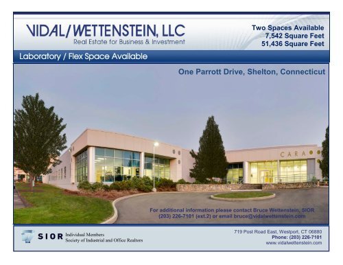
<strong>Laboratory</strong> / <strong>Flex</strong> <strong>Space</strong> <strong>Available</strong><br />
Two <strong>Space</strong>s <strong>Available</strong><br />
7,542 Square Feet<br />
51,436 Square Feet<br />
<strong>One</strong> <strong>Parrott</strong> <strong>Drive</strong>, <strong>Shelton</strong>, <strong>Connecticut</strong><br />
For additional information please contact Bruce Wettenstein, SIOR<br />
(203) 226-7101 (ext.2) or email bruce@vidalwettenstein.com<br />
Individual Members<br />
Society of Industrial and Office Realtors<br />
719 Post Road East, Westport, CT 06880<br />
Phone: (203) 226-7101<br />
www.vidalwettenstein.com
<strong>One</strong> <strong>Parrott</strong> <strong>Drive</strong>, <strong>Shelton</strong>, <strong>Connecticut</strong><br />
Square Feet:<br />
Parking:<br />
Comments:<br />
Building Size:<br />
Lease Rate:<br />
59,000 SF, two separate units can be expanded to 100,000 SF<br />
3 spaces per 1,000 RSF<br />
Fully functional wet, bio, chemistry, Vivarium, laboratory with<br />
a High Thru Put Screening room.<br />
Reversed osmosis deionized water system (RODI)<br />
Medical grade dry compressed air<br />
Multiple lab hoods, counters, many laboratory amenities.<br />
Dual 300 gallon gas fired hot water<br />
Hazardous waste and radioactive waste storage facility<br />
Two 12’ x 12’ loading docks with levelers<br />
100,000 RSF single story flex building<br />
Professional building management provided by Cambridge<br />
Hanover<br />
Negotiable<br />
Location: Conveniently located near Route 8 exits 11 & 12<br />
Local amenities include hotels, banking, shopping and<br />
multiple restaurants.<br />
Route 8<br />
Exit 12<br />
Route 8 Exit 11<br />
719 Post Road East, Westport, CT 06880 ·Phone: 203.226.7101 · vidalwettenstein.com<br />
All information from sources deemed reliable and is submitted subject to errors, omissions, change of price, rental, and property sale and withdrawal notice.
<strong>One</strong> <strong>Parrott</strong> <strong>Drive</strong>, <strong>Shelton</strong>, <strong>Connecticut</strong><br />
Lobby<br />
Lab<br />
Conference room<br />
Lab<br />
Office<br />
Lab<br />
Patio<br />
719 Post Road East, Westport, CT 06880 ·Phone: 203.226.7101 · vidalwettenstein.com<br />
All information from sources deemed reliable and is submitted subject to errors, omissions, change of price, rental, and property sale and withdrawal notice.
<strong>One</strong> <strong>Parrott</strong> <strong>Drive</strong>, <strong>Shelton</strong>, <strong>Connecticut</strong><br />
51,436 Square Feet<br />
719 Post Road East, Westport, CT 06880 ·Phone: 203.226.7101 · vidalwettenstein.com<br />
All information from sources deemed reliable and is submitted subject to errors, omissions, change of price, rental, and property sale and withdrawal notice.
<strong>One</strong> <strong>Parrott</strong> <strong>Drive</strong>, <strong>Shelton</strong>, <strong>Connecticut</strong><br />
7,542 Square Feet<br />
719 Post Road East, Westport, CT 06880 ·Phone: 203.226.7101 · vidalwettenstein.com<br />
All information from sources deemed reliable and is submitted subject to errors, omissions, change of price, rental, and property sale and withdrawal notice.
<strong>Shelton</strong>, <strong>Connecticut</strong><br />
CERC Town Profile 2014<br />
Town Hall<br />
54 Hill Street<br />
<strong>Shelton</strong>, CT 06484<br />
(203) 924-1555<br />
Demographics<br />
Population (2012)<br />
2000<br />
2010<br />
2012<br />
2020<br />
'12-'20 Growth / Yr<br />
Belongs to<br />
Fairfield County<br />
LMA Bridgeport - Stamford<br />
Valley Economic Dev. Region<br />
Valley Planning Area<br />
Town County State<br />
38,101<br />
39,061<br />
39,641<br />
40,091<br />
0.1%<br />
882,567<br />
905,342<br />
918,892<br />
940,616<br />
0.3%<br />
3,405,565<br />
3,545,837<br />
3,572,213<br />
3,690,997<br />
0.4%<br />
Land Area (sq. miles)<br />
Pop./ Sq. Mile (2012)<br />
31<br />
1,297<br />
626<br />
1,468<br />
4,845<br />
737<br />
Median Age (2012) 45 40 40<br />
Households (2012) 15,019 332,968 1,360,184<br />
Med HH Inc. (2012) $83,755 $82,614 $69,519<br />
Economics<br />
Race/Ethnicity (2012)<br />
White<br />
Black<br />
Asian Pacific<br />
Native American<br />
Other/Multi-Race<br />
Hispanic (any race)<br />
Business Profile (2013) Top Five Grand List (2013)<br />
Education<br />
2010-2011 School Year<br />
Total Town School Enrollment<br />
Town<br />
5,548<br />
Most public school students in <strong>Shelton</strong> attend <strong>Shelton</strong> School<br />
District, which has 5,286 students.<br />
For more education data see:<br />
http://sdeportal.ct.gov/Cedar/<br />
WEB/ResearchandReports/SS<br />
PReports.aspx<br />
Town Profiles October, 2014. Page 1<br />
State<br />
548,313<br />
Students per Computer Town State<br />
Elementary: 3.1<br />
Middle: 1.9<br />
Secondary: 2.6<br />
www.cerc.com<br />
Brennan Realty Llc<br />
BIC Corp<br />
Prudential Financial<br />
Incorporated in 1789<br />
Town County State<br />
36,647<br />
813<br />
1,146<br />
28<br />
699,870<br />
99,871<br />
43,203<br />
1,439<br />
2,802,217<br />
355,660<br />
139,827<br />
8,531<br />
1,007 74,509 265,978<br />
2,529 155,557 480,185<br />
Poverty Rate (2012) 4.4% 8.8% 10.0%<br />
Educational Attainment (2012)<br />
Persons Age 25 or Older<br />
High School Graduate<br />
Associates Degree<br />
Town<br />
8,709<br />
2,368<br />
%<br />
30%<br />
8%<br />
State<br />
677,253<br />
177,531<br />
%<br />
28%<br />
7%<br />
Bachelors or Higher 10,347 36% 879,089 36%<br />
Age Distribution (2012)<br />
0-4 5-17 18-24 25-49 50-64 65+ Total<br />
Male<br />
885 2% 3,027 8% 1,269 3% 6,309 16% 4,339 11% 3,023 8% 18,852<br />
Female<br />
772 2% 3,306 8% 1,480 4% 6,451 16% 4,692 12% 4,088 10% 20,789<br />
County Total 56,435 6% 169,978 18% 73,098 8% 314,538 34% 179,794 20% 125,049 14% 918,892<br />
State Total 200,031 6% 612,181 17% 328,661 9% 1,194,793 33% 726,725 20% 509,822 14% 3,572,213<br />
Sector Units Employment<br />
Total - All Industries 1,306 22,050<br />
23 Construction 106 462<br />
31 Manufacturing 73 4,286<br />
44 Retail Trade 95 1,827<br />
54 Prof, Scientific, and Technical Svcs 189 1,716<br />
56 Admin,Waste Mgmt, Remediation 94 2,526<br />
62 Health Care and Social Assistance 110 2,677<br />
Total Government 20 1,222<br />
Robert Scinto $226,640,670<br />
Pitney Bowes Inc $45,525,790<br />
United Illuminating $44,170,600<br />
Aquarion Water Co $37,075,300<br />
Health New of Califorina Real Estate $33,395,800<br />
Net Grand List (2013)<br />
$4,514,471,490<br />
Major Employers (2014)<br />
4.1<br />
2.7<br />
2.9<br />
Average Class Size<br />
Pitney Bowes Inc<br />
Super Stop & Shop<br />
<strong>Connecticut</strong> Mastery Test Percent Above Goal<br />
Reading<br />
Math<br />
Writing<br />
Grade K 21.1 Grade 2 22.1<br />
Grade 5 23.1 Grade 7 25.4<br />
High School 18.9<br />
Amount<br />
% of<br />
Net<br />
5.0%<br />
1.0%<br />
1.0%<br />
0.8%<br />
0.7%<br />
Grade 4 Grade 6 Grade 8<br />
Town State Town State Town State<br />
74 63 89 76 84 75<br />
72 67 86 72 80 67<br />
77 67 79 65 NA 65<br />
Average SAT Score<br />
Town State<br />
Reading<br />
Writing<br />
500<br />
494<br />
502<br />
506<br />
Math 510 506<br />
No representation or warranties, expressed or implied, are<br />
given regarding the accuracy of this information.
<strong>Shelton</strong><br />
<strong>Connecticut</strong><br />
Government<br />
Government Form: Mayor-Board of Aldermen<br />
Total Revenue (2012)<br />
Tax Revenue<br />
Non-tax Revenue<br />
Intergovernmental<br />
Per Capita Tax (2012)<br />
As % of State Average<br />
$116,364,658<br />
$97,299,584<br />
$19,065,074<br />
$15,116,799<br />
$2,455<br />
95.1%<br />
Total Expenditures (2012)<br />
Education<br />
Other<br />
Total Indebtness (2012)<br />
As % of Expenditures<br />
Per Capita<br />
As % of State Average<br />
$113,998,176<br />
$71,812,630<br />
$42,185,546<br />
$59,375,000<br />
52.1%<br />
$1,498<br />
66.4%<br />
Annual Debt Service (2012)<br />
As % of Expenditures<br />
$11,080,779<br />
9.7%<br />
Eq. Net Grand List (2010) $6,465,685,754<br />
Per Capita $163,106<br />
As % of State Average<br />
113%<br />
Moody's Bond Rating (2012)<br />
Actual Mill Rate (2012)<br />
Equalized Mill Rate (2012)<br />
% of Grand List Com/Ind (2010)<br />
Aa2<br />
18.57<br />
15.09<br />
16.3%<br />
Housing/Real Estate<br />
Housing Stock (2012)<br />
Total Units<br />
% Single Unit<br />
New Permits Auth. (2012)<br />
As % Existing Units<br />
Demolitions (2012)<br />
House Sales (2011)<br />
Median Price<br />
Built Pre 1950 share (2012)<br />
Place of Residence (2013)<br />
Labor Force<br />
Employed<br />
Unemployed<br />
Unemployment Rate<br />
Total Employment<br />
Mfg Employment<br />
Crime Rate (2012)<br />
Library (2013)<br />
Labor Force<br />
Place of Work (2013)<br />
Units<br />
2000-'13 AAGR<br />
Other Information<br />
Per 100,000 Residents<br />
Public Web Computers<br />
Circulation per Capita<br />
Families Receiving (2014)<br />
Temporary Assistance<br />
Population Receiving (2014)<br />
Food Stamps<br />
Town Profiles October, 2014. Page 2<br />
Town County State<br />
15,858 360,692 1,485,445<br />
80.0% 64.4% 64.6%<br />
1.89% 0.59% 0.31%<br />
7 386 955<br />
NA<br />
NA $570,000 $291,000<br />
19.1% 29.7% 30.2%<br />
Town County State<br />
22,492<br />
20,920<br />
1,572<br />
7.0%<br />
Town<br />
471,992<br />
438,621<br />
33,371<br />
7.1%<br />
1,859,934<br />
1,715,398<br />
144,536<br />
7.8%<br />
413,404 1,640,223<br />
4,286 35,961 163,828<br />
1,138 2,433<br />
15<br />
6<br />
299<br />
2,138<br />
4,485 13,847<br />
-0.3% 0.2%<br />
Distance to Major Cities<br />
Hartford<br />
Boston<br />
New York City<br />
Providence<br />
4,669<br />
1,306 33,728 113,697<br />
22,050<br />
0.3%<br />
134<br />
1,878<br />
State<br />
www.cerc.com<br />
Owner Occupied Dwellings (2012)<br />
As % Total Dwellings<br />
Subsidized Housing (2012)<br />
Distribution of House Sales (2011)<br />
Number of Sales<br />
Less than $100,000<br />
$100,000-$199,999<br />
$200,000-$299,999<br />
$300,000-$399,999<br />
$400,000 or More<br />
Town County State<br />
NA<br />
NA<br />
NA<br />
NA<br />
NA<br />
392<br />
3,205<br />
3,494<br />
2,086<br />
4,670<br />
<strong>Connecticut</strong> Commuters (2011)<br />
Commuters into Town from: Town Residents Commuting to:<br />
<strong>Shelton</strong> 3,335 <strong>Shelton</strong> 3,335<br />
Bridgeport 1,998 Bridgeport 2,343<br />
Stratford 1,307 Stratford 1,595<br />
Milford 1,082 Trumbull 984<br />
Trumbull 868 New Haven 944<br />
Ansonia 761 Fairfield 906<br />
Seymour 734 Milford 888<br />
Derby 604 Stamford 848<br />
Fairfield 586 Norwalk 817<br />
Miles<br />
40<br />
131<br />
60<br />
96<br />
Residential Utilities<br />
Electric Provider<br />
The United Illuminating Co.<br />
(800) 257-0141<br />
Gas Provider<br />
Yankee Gas Company<br />
(800) 989-0900<br />
Water Provider<br />
Aquarion Water Company<br />
(800) 732-9678<br />
Cable Provider<br />
Comcast Seymour<br />
(800) 266-2278<br />
12,353 232,128 929,560<br />
78% 64% 63%<br />
440 31,049 161,379<br />
57<br />
338<br />
511<br />
564<br />
3,015<br />
No representation or warranties, expressed or implied, are<br />
given regarding the accuracy of this information.