

60sManagingFloodEventsHardEngineering

You also want an ePaper? Increase the reach of your titles
YUMPU automatically turns print PDFs into web optimized ePapers that Google loves.
A 60 SECOND GUIDE TO . . .<br />
Managing Flood Events (Hard Engineering)<br />
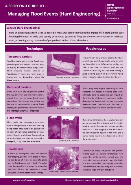
What is Hard Engineering?<br />
Hard Engineering is a term used to describe measures taken to prevent the impact of a hazard (in this case<br />
flooding) by means of built, and usually permanent, structures. They are the most common set of methods<br />
used, protecting many thousands of people both in the UK and elsewhere.<br />
Technique<br />
Weaknesses<br />
Temporary Barriers<br />
Sand bag walls and portable flood gates<br />
provide quick and easy to construct ways<br />
of dealing with small floods. Large, water<br />
filled inflatable barriers (known as<br />
‘aquabarriers’) have also been used in<br />
towns such as Shrewsbury along the<br />
River Severn.<br />
Dams and Barriers<br />
Dams of all sizes are designed to control<br />
the flow of a river and with monitoring of<br />
rainfall levels can be opened and closed<br />
accordingly. Barriers act in a similar way<br />
but are only deployed in times of flood,<br />
creating no permanent reservoir such as<br />
the Thames Barrier near Woolwich.<br />
Sandbags, Morpeth / Ian Britton<br />
Foss Barrier, York / Neil Turner<br />
These barriers only protect against floods of<br />
a small size and should really only be used<br />
for those that occur infrequently as they can<br />
take some time to deploy and set up.<br />
Therefore they rely on the area having a<br />
good warning system in place which would<br />
allow residents and authorities time to act.<br />
Whilst they may appear reassuring to local<br />
residents the impact of holding back water<br />
artificially (and its sediment) can impact on<br />
the integrity of damage ecosystems further<br />
downstream. Permanent barriers can create<br />
reservoirs over farmland and the need to<br />
relocate people if they live behind the dam.<br />
Flood Walls<br />
Flood walls are permanent structures<br />
that sit alongside the river bank, blocking<br />
rising water. They tend to be placed only<br />
in front of high value buildings or areas<br />
rather than in a wholesale fashion along<br />
an entire bank. An example is found in<br />
Morpeth, along the River Wansbeck.<br />
Flood wall, York / Paul Kelly<br />
If designed sensitively, these walls might not<br />
be an eye sore for residents but they often<br />
block access to the river and restrict people’s<br />
views of it. Once topped, it can be difficult<br />
for flood water to return to the river and a<br />
pump would need to be deployed to drain<br />
the water away.<br />
Revetments<br />
In order to strengthen them and prevent<br />
over topping, gabions (wire cages of rocks),<br />
rip rap (piles of rocks) or concrete piling<br />
may artificially cover a river bank. They also<br />
slow the speed of the water by increasing<br />
the bank friction. An example is found<br />
along the Stanford Brook near Crawley.<br />
Gabion bank, Crawley / George Redgrave<br />
Concrete or metal structures can prevent<br />
wildlife (such as nesting kingfishers) from<br />
using the banks in their normal way and<br />
vegetation may not grow to cover the banks<br />
in a way that makes them appear natural to<br />
river side users. Their building and placement<br />
can cause large levels of disruption.<br />
www.rgs.org/education<br />
Members only access to over 300 case studies and articles
A 60 SECOND GUIDE TO . . .<br />
Managing Technique Flood Events (Hard Engineering)<br />
Weaknesses<br />
Relief Channels<br />
In areas that are particularly built up it can<br />
be difficult to put permanent barriers in<br />
place next to the river. An alternative is a<br />
new channel, in addition to the original<br />
one that can take the excess water around<br />
the town, re-joining it at a later point, for<br />
example the River Thames at Oxford.<br />
Relief Channel, R.Lea, London / Gordon<br />
Joly<br />
In intense floods there is no guarantee that<br />
the relief channel itself will not flood,<br />
potentially causing an area to become<br />
marooned between a river and its relief<br />
channel. Channels can also be expensive to<br />
build and require a significant change in land<br />
use.<br />
Channel Dredging<br />
Over time silt and mud builds up in some<br />
parts of a river system, changing the shape<br />
of the river banks and bed and reducing the<br />
river’s capacity. Dredging, by scooping up<br />
and removing this build up, reducing the<br />
chance of flooding. This has happened on<br />
the River Thames at Maidenhead.<br />
Channel Lining<br />
Lining the river banks, and sometimes the<br />
beds with concrete can reduce the friction<br />
that exists between the banks and the<br />
water, speeding any flood water quickly<br />
past built up areas and onto places that<br />
hold less land value. An example of this is<br />
the River Brent in Brent, London.<br />
River dredging, Basingstoke /IrBrl<br />
Channel Lining, Brent, London / diamond<br />
geezer<br />
Removing the river’s natural silt means that<br />
fewer nutrients find their way onto the flood<br />
plain during seasonal low level flooding and<br />
farm land can suffer lower fertility for this.<br />
There is also some evidence that dredging<br />
can actually increase the silt build up in other<br />
parts of a river, making the process far less<br />
effective.<br />
Species that nest in the banks of a river are<br />
forced to move to other areas and ultimately<br />
the natural feel of the river is lost. By<br />
reducing the friction and speeding the water<br />
through a town, areas further downstream of<br />
lining point can become flooded in times of<br />
even moderate rainfall.<br />
Channel Straightening<br />
Straightening a river channel increases<br />
the speed at which flood water can flow<br />
through an area, protecting the built up<br />
environment either side of the channel<br />
at that point. Most of the UK’s main<br />
rivers have some degree of straightening,<br />
for example the River Avon in Salisbury.<br />
River Straightening, R.Tone, Somerset /<br />
Ian Chilton<br />
Straightening a river channel changes the<br />
natural flow of a river and, as with lining a<br />
channel, can ironically push a flood problem<br />
further downstream. Rivers will naturally try<br />
to meander across a flood plain, so unless<br />
the banks are lined with a permanent lining a<br />
river will revert to its original meanders.<br />
Groynes<br />
Acting as barriers that jut out across the<br />
channel, groynes slow down the pace of the<br />
river and can temporarily hold flood water<br />
back before it enters a part of the river<br />
system where land use is more valued. The<br />
River Quaggy in Lewisham, London is an<br />
example of a river with these in place.<br />
Groynes, R.Quaggy, Lewisham / alcinababe<br />
In slow running streams the groynes can<br />
cause sedimentation in the river channel,<br />
which in times of high rainfall can exacerbate<br />
the chance of flooding greatly. Groynes also<br />
make any navigation of a channel nearly<br />
impossible for boats and some wildlife.<br />
www.rgs.org/education<br />
Members only access to over 300 case studies and articles