APPLICATIONS FOR FIRST REGISTRATION - National Land Agency
APPLICATIONS FOR FIRST REGISTRATION - National Land Agency
APPLICATIONS FOR FIRST REGISTRATION - National Land Agency

You also want an ePaper? Increase the reach of your titles
YUMPU automatically turns print PDFs into web optimized ePapers that Google loves.
the surveyor must be accurately stated. The Surveyors Diagram must set out the<br />
area of the land in metric units, and cannot be used unless the Director of<br />
Surveys has certified it (pre-checked).<br />
<strong>Land</strong>s described by Metes and Bound<br />
The land must be so described as to enable identification of the location of the<br />
parcel on the ground by reference to a landmark and must state the name or<br />
names by which the property is known as well as the parish in which it is<br />
located. The description must state the distances (in metric units) between and<br />
direction of the line of each boundary by reference to the points of the compass;<br />
if the boundary is not a straight line, the distances between each change of<br />
direction must be given. The description must give the names by which the<br />
abutting lands are known, the names of the abutting owners, and where the<br />
abutting land is registered land the Volume and Folio number of that land. The<br />
<strong>Land</strong> Valuation references number for the abutting properties must be given. If<br />
necessary the applicant should secure the assistance of a person versed in the<br />
art of land surveys.<br />
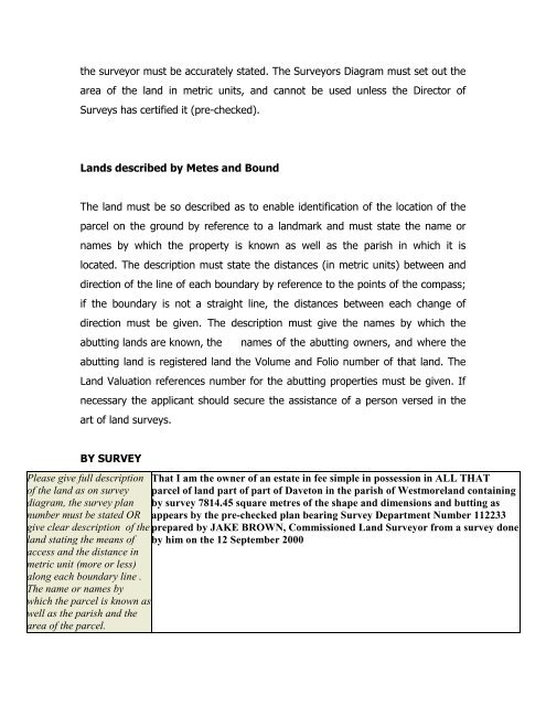
BY SURVEY<br />
Please give full description<br />
of the land as on survey<br />
diagram, the survey plan<br />
number must be stated OR<br />
give clear description of the<br />
land stating the means of<br />
access and the distance in<br />
metric unit (more or less)<br />
along each boundary line .<br />
The name or names by<br />
which the parcel is known as<br />
well as the parish and the<br />
area of the parcel.<br />
That I am the owner of an estate in fee simple in possession in ALL THAT<br />
parcel of land part of part of Daveton in the parish of Westmoreland containing<br />
by survey 7814.45 square metres of the shape and dimensions and butting as<br />
appears by the pre-checked plan bearing Survey Department Number 112233<br />
prepared by JAKE BROWN, Commissioned <strong>Land</strong> Surveyor from a survey done<br />
by him on the 12 September 2000