

Commercial Marine Shipping Accidents Understanding Risks Canada
cca_marine_shipping_risks_en_fullreport
cca_marine_shipping_risks_en_fullreport

You also want an ePaper? Increase the reach of your titles
YUMPU automatically turns print PDFs into web optimized ePapers that Google loves.
Chapter 2 <strong>Commercial</strong> <strong>Marine</strong> <strong>Shipping</strong> Activity and Accident Prevention in <strong>Canada</strong><br />
11<br />
Northern <strong>Canada</strong> and Labrador Great Lakes<br />
Port of Thunder Bay<br />
Port of Hamilton<br />
Port of Nanticoke<br />
British Columbia St. Lawrence, Maritimes, and Newfoundland<br />
Port of Prince Rupert<br />
Port of Sept-Îles<br />
Port Cartier<br />
Port of Québec<br />
Port of Come<br />
By Chance<br />
Offshore<br />
Newfoundland<br />
Oil Fields<br />
Port Metro Vancouver<br />
Port of Sorel<br />
Port of Montréal<br />
Port of Saint John<br />
Port of Halifax<br />
Port<br />
Hawkesbury<br />
Data Source: StatCan, 2012b; <strong>Marine</strong>Traffic, 2015<br />
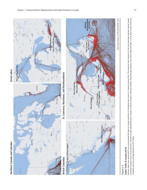
Figure 2.3<br />
Tanker Traffic in <strong>Canada</strong> (2014)<br />
Density maps were generated from accumulated AIS data on tanker positions in Canadian and some U.S. waters during 2014. The location and intensity of the red markings indicate overall vessel<br />
movement patterns and concentrations. Tankers include asphalt/bitumen tankers, crude oil tankers, chemical tankers, liquefied gas tankers, and others (<strong>Marine</strong>Traffic, n.d.-c). Blue circles mark top<br />
Canadian ports by tonnage (based on 2011 data).