

Accessible Britain
o4Nb301YbAS
o4Nb301YbAS

You also want an ePaper? Increase the reach of your titles
YUMPU automatically turns print PDFs into web optimized ePapers that Google loves.
A619<br />
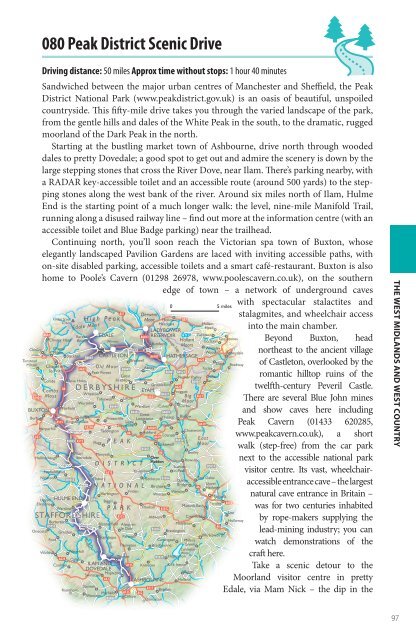
080 Peak District Scenic Drive<br />
Driving distance: 50 miles Approx time without stops: 1 hour 40 minutes<br />
Sandwiched between the major urban centres of Manchester and Sheffield, the Peak<br />
District National Park (www.peakdistrict.gov.uk) is an oasis of beautiful, unspoiled<br />
countryside. This fifty-mile drive takes you through the varied landscape of the park,<br />
from the gentle hills and dales of the White Peak in the south, to the dramatic, rugged<br />
moorland of the Dark Peak in the north.<br />
Starting at the bustling market town of Ashbourne, drive north through wooded<br />
dales to pretty Dovedale; a good spot to get out and admire the scenery is down by the<br />
large stepping stones that cross the River Dove, near Ilam. There’s parking nearby, with<br />
a RADAR key-accessible toilet and an accessible route (around 500 yards) to the stepping<br />
stones along the west bank of the river. Around six miles north of Ilam, Hulme<br />
End is the starting point of a much longer walk: the level, nine-mile Manifold Trail,<br />
running along a disused railway line – find out more at the information centre (with an<br />
accessible toilet and Blue Badge parking) near the trailhead.<br />
Continuing north, you’ll soon reach the Victorian spa town of Buxton, whose<br />
elegantly landscaped Pavilion Gardens are laced with inviting accessible paths, with<br />
on-site disabled parking, accessible toilets and a smart café-restaurant. Buxton is also<br />
home to Poole’s Cavern (01298 26978, www.poolescavern.co.uk), on the southern<br />
edge of town – a network of underground caves<br />
Kinder Scout<br />
636m<br />
Manifold<br />
Alshop<br />
High Peak<br />
Edale Moor<br />
Dove<br />
Wye<br />
A57<br />
Noe<br />
Derwent<br />
Moor Hollow<br />
Meadows<br />
0 5 miles<br />
Hallam<br />
Head<br />
LADYBOWER<br />
A624<br />
Barber EDALE<br />
A6013 RESERVOIR<br />
Fulwood<br />
Chinley Head Booth<br />
Winnats<br />
Hallam<br />
Greystones<br />
Ecclesall<br />
Pass<br />
Bamford Moors<br />
Chinley Chapel<br />
Hope Thornhill<br />
Whiteley<br />
Milton<br />
Wood Abbeydale<br />
A6<br />
Slackhall B6061 CASTLETON<br />
A6187 HATHERSAGE<br />
Tunstead<br />
Bradwell<br />
A625<br />
Milton<br />
Sparrowpit<br />
Dore<br />
Chapel-enle-Frith<br />
Peak Forest<br />
B6001 B6521<br />
Bradway<br />
Old Moor<br />
A623<br />
B6049 Abney<br />
Totley<br />
Great<br />
Nether Padley Owler<br />
Combs Dove Holes<br />
Hucklow Bretton<br />
B6064 Bar<br />
Grindleford<br />
A625<br />
A6<br />
Combs<br />
DERBYSHIRE EYAM Froggatt<br />
Wheston<br />
B6521<br />
A5004 Moss<br />
A623<br />
Big A621<br />
Tideswell Litton<br />
Wormhill<br />
Moor<br />
B6049 Wardlow Calver Curbar<br />
Fairfield<br />
BUXTON<br />
B6465<br />
B6001<br />
Great<br />
Burbage<br />
Blackwell<br />
Priestcliffe<br />
Hassop Baslow<br />
Longstone<br />
A515 Kingsterndale<br />
Little<br />
A5270<br />
Longstone<br />
Pilsley<br />
Harpurhill<br />
A6020<br />
Chelmorton Taddington<br />
Chatsworth<br />
A6 Ashford<br />
A53<br />
A619<br />
Edensor<br />
B5053 A515<br />
B6012 East<br />
Flagg PEAK<br />
Bakewell Moor<br />
B5055<br />
Earl<br />
A6<br />
Monyash<br />
Beeley<br />
Hollinsclough Sterndale<br />
Over<br />
Haddon<br />
Rowsley<br />
Longnor DISTRICT<br />
Stanton<br />
B5057<br />
Fawfieldhead<br />
A515<br />
Youlgreave<br />
in-Peak<br />
Newton<br />
B5053 Pilsbury<br />
Middleton B5056<br />
Two Dales<br />
Darley<br />
Sheen NATIONAL Birchover<br />
Bridge Upper<br />
A6 Hackney<br />
Friden<br />
Wensley<br />
Hartington<br />
Winster<br />
Upper HULME END<br />
Matlock<br />
B5054<br />
Biggin<br />
Elkstone<br />
Tansley A615<br />
Warslow<br />
PARK Pikehall<br />
Matlock Bath<br />
A5012<br />
Lea<br />
STAFFORDSHIRE A515<br />
Aldwark<br />
Cromford<br />
Butterton<br />
Holloway<br />
Alstonefield<br />
B5053<br />
Wetton<br />
Alsop en<br />
Middleton<br />
A6<br />
le Dale<br />
B5056<br />
Onecote Grindon<br />
Brassington<br />
Stanshope Parwich<br />
Wirksworth<br />
Ford<br />
Carsington Millers<br />
Tissington Bradbourne Green<br />
Carsington<br />
Winkhill Waterfall<br />
Water<br />
Thorpe<br />
A523<br />
B5035 Hognaston<br />
Calton<br />
Cauldon ILAM AND A515 Kniveton Kirk Ireton<br />
DOVEDALE<br />
Mapleton<br />
Biggin<br />
Swinscoe<br />
A52 ASHBOURNE Hulland<br />
Stanton<br />
A517<br />
Ramshorn<br />
Bradley<br />
Mayfield A515 A52<br />
Wootton<br />
B5032 Clifton<br />
Osmaston<br />
Stanage Edge<br />
A57<br />
Derwent<br />
with spectacular stalactites and<br />
stalagmites, and wheelchair access<br />
into the main chamber.<br />
Beyond Buxton, head<br />
northeast to the ancient village<br />
of Castleton, overlooked by the<br />
romantic hilltop ruins of the<br />
twelfth-century Peveril Castle.<br />
There are several Blue John mines<br />
and show caves here including<br />
Peak Cavern (01433 620285,<br />
www.peakcavern.co.uk), a short<br />
walk (step-free) from the car park<br />
next to the accessible national park<br />
visitor centre. Its vast, wheelchairaccessible<br />
entrance cave – the largest<br />
natural cave entrance in <strong>Britain</strong> –<br />
was for two centuries inhabited<br />
by rope-makers supplying the<br />
lead-mining industry; you can<br />
watch demonstrations of the<br />
craft here.<br />
Take a scenic detour to the<br />
Moorland visitor centre in pretty<br />
Edale, via Mam Nick – the dip in the<br />
THE WEST MIDLANDS AND WEST COUNTRY<br />
97