JaxReady_EPG_2016

You also want an ePaper? Increase the reach of your titles
YUMPU automatically turns print PDFs into web optimized ePapers that Google loves.
Flooding<br />
Locally heavy rainfall that causes minor temporary flooding of low<br />
lying areas is common from showers and thunderstorms. A flood<br />
warning will be issued when flood waters threaten life or property.<br />
Flooding Facts<br />
• One foot of flowing water will move a small car.<br />
• More than half of flooding deaths occur in vehicles.<br />
Types of Flooding Fresh Water Rainfall Coastal River & Estuary Storm Surge<br />
Vulnerable areas<br />
(not exclusive):<br />
• All areas are subject<br />
to heavy rainfall<br />
flooding<br />
• Most prone areas<br />
include Riverside,<br />
San Marco, and 8th<br />
Street in Jacksonville<br />
• Areas near McCoys<br />
Creek, Hogan Creek,<br />
and Moncrief Creek<br />
• Jacksonville Beach<br />
• Coastal locations<br />
including<br />
Jacksonville Beach,<br />
Atlantic Beach, and<br />
Neptune Beach<br />
• Where beach erosion<br />
is most common<br />
during high tide<br />
• Waterfront interests<br />
including those<br />
along beaches,<br />
Intracoastal<br />
Waterway, St.<br />
Johns River, and<br />
its tributaries, and<br />
marshes<br />
• Coastal and<br />
intracoastal<br />
communities<br />
• Communities near<br />
inland rivers and<br />
creeks including the<br />
the St. Marys, Trout,<br />
Ortega, and St.<br />
Johns Rivers<br />
• Communities near<br />
Julington Creek<br />
Situation that may<br />
cause the flooding<br />
Sources of information<br />
• Poor drainage areas<br />
• Slow moving<br />
showers and<br />
thunderstorms<br />
• Long bands of<br />
showers and storms<br />
Radar Imagery:<br />
radar.weather.gov<br />
Potential Rainfall:<br />
wpc.noaa.gov<br />
• Strong and<br />
persistent onshore<br />
fl o w<br />
• Higher than normal<br />
astronomical tides<br />
Tide Information:<br />
tidesandcurrents.noaa.<br />
gov<br />
Weather Information:<br />
weather.gov/jax<br />
• Above normal rainfall<br />
combined with high<br />
astronomical tides<br />
• Tropical system<br />
Monitor Rivers:<br />
water.weather.gov<br />
• Tropical system<br />
• Strong storm system<br />
over the Atlantic<br />
Ocean (non-tropical)<br />
National Hurricane<br />
Center:<br />
nhc.noaa.gov<br />
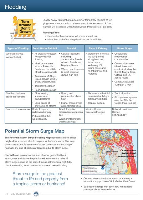
Potential Storm Surge Map<br />
The Potential Storm Surge Flooding Map represents storm surge<br />
heights that a person should prepare for before a storm. The map<br />
shows a reasonable estimate of worst case scenario flooding of<br />
normally dry land at particular locations due to storm surge.<br />
Storm Surge is an abnormal rise of water generated by a<br />
storm, over and above the predicated astronomical tides. If<br />
storm surge occurs at the same time as astronomical high tide,<br />
then the resulting inland water can cause extreme flooding.<br />
Storm surge is the greatest<br />
threat to life and property from<br />
a tropical storm or hurricane!<br />
3 City of Jacksonville<br />
Atlantic Beach<br />
Jacksonville<br />
Neptune Beach<br />
Jacksonville Beach<br />
• Created when a hurricane watch or warning is<br />
issued for any portion of U.S. Gulf or East Coast.<br />
• Subject to change with each new full advisory<br />
package, about every 6 hours.